China's Activities in the South China Sea - China's development activities on the features and trends in related countries

Page created by Tracy Aguilar
 
CONTINUE READING
China's Activities in the South China Sea - China's development activities on the features and trends in related countries
China’s Activities in the South China Sea
(China’s development activities on the features
      and trends in related countries)

                  March 2021
            Japan Ministry of Defense
China's Activities in the South China Sea - China's development activities on the features and trends in related countries
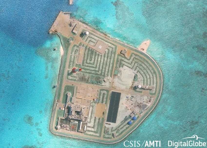
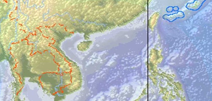
(Summary 1/3) Overall View of the South China Sea (SCS)
● In the SCS, claims conflict between ASEAN countries and China over the territorial rights of
               Laos
 Spratly and Paracel islands      China
                               Paracel Islands
                                                                             Philippines
                                                  Woody Island
            Thailand                   Scarborough Shoal                      China, Taiwan &
                                  Vietnam                                      Vietnam claim
                                                                                 territorial
                  Cambodia                   Spratly Islands                 sovereignty of the
                                           ③Subi Reef                          Paracel Islands
        China, Taiwan,                                     ⑤Gaven Reef
    Vietnam & Philippines          ①Fiery Cross Reef              ②Mischief Reef
     etc. claim territorial                                      ⑦Hughes Reef
     sovereignty of seven          ④Cuarteron Reef
      features etc. in the                             ⑥Johnson South Reef
        Spratly Islands

                       “Nine-dash line” Brunei
                                       Malaysia Indonesia
                                                       0           500             1,000km
                                                                                        ※ Image   ❶
China's Activities in the South China Sea - China's development activities on the features and trends in related countries
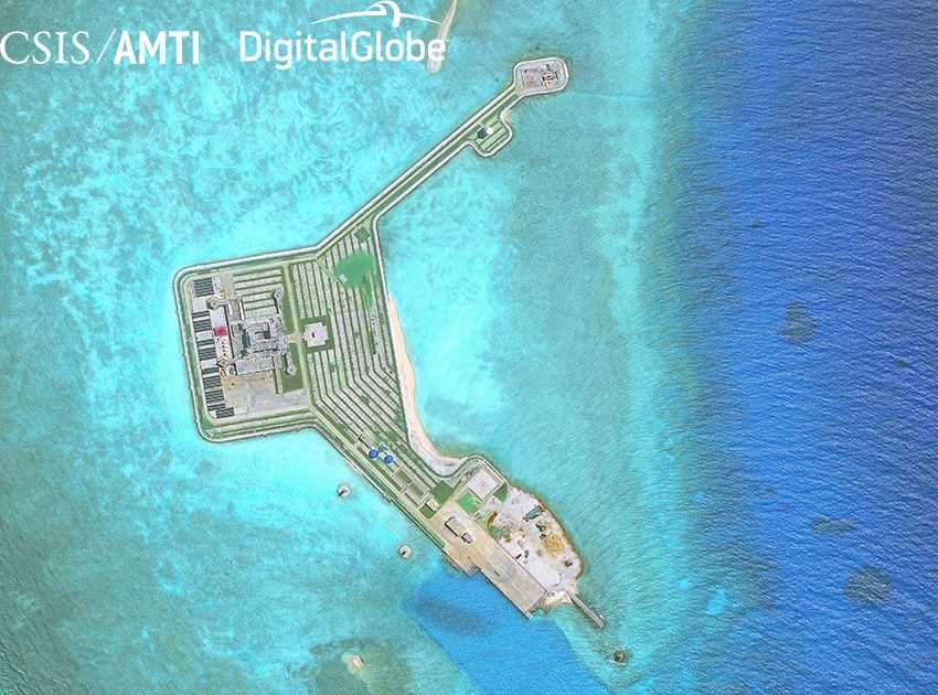
(Summary 2/3) China’s Reclamation Activities in the SCS
    Since 2014, China has pressed ahead with rapid and large-scale land reclamation works in 7 features in the Spratlys. By
    the late-2015 when the reclamation had been mostly completed, area of the reclamation work was approx. 12.9 ㎢
    (Other countries in the region conducted land reclamation of approx. 0.2 ㎢ in the same period of time).
    After completing reclamation, China militarizes the features further, continuously developing various infrastructure and
    deploying military assets.
    In November 2018, it was reported that China installed what appears to be an information collection sensor in Bombay
    Reef in the Paracels without large-scale reclamation.
    August 2014                                  March2015                                     March 2013                             November 2014

              March 2020                                                                          October 2017
          After reclamation: App.2.72㎢                                                          After reclamation: App.0.247㎢
          (Reclamation completed in 2015)                                                       (Reclamation completed in 2014)                         Gun battery

                                                                                                    Radar/Sensor Array

                App.3,750m
                                                                                                                                                Headquarters
                                                             Large harbor

                                                  Runway
                                               (app. 3,000m)                                                                                           Helipad
                                                                                                  Multiple poles
                                                                                                   (HF radar
                                                      Fiery Cross Reef                            〔possibly〕)                               Cuarteron Reef
Sources:CSIS Asia Maritime Transparency Initiative (photo) / U.S. DoD Annual Report to Congress 2016,2017 /Google Earth (length)/ Media reports etc.                  ❷
China's Activities in the South China Sea - China's development activities on the features and trends in related countries
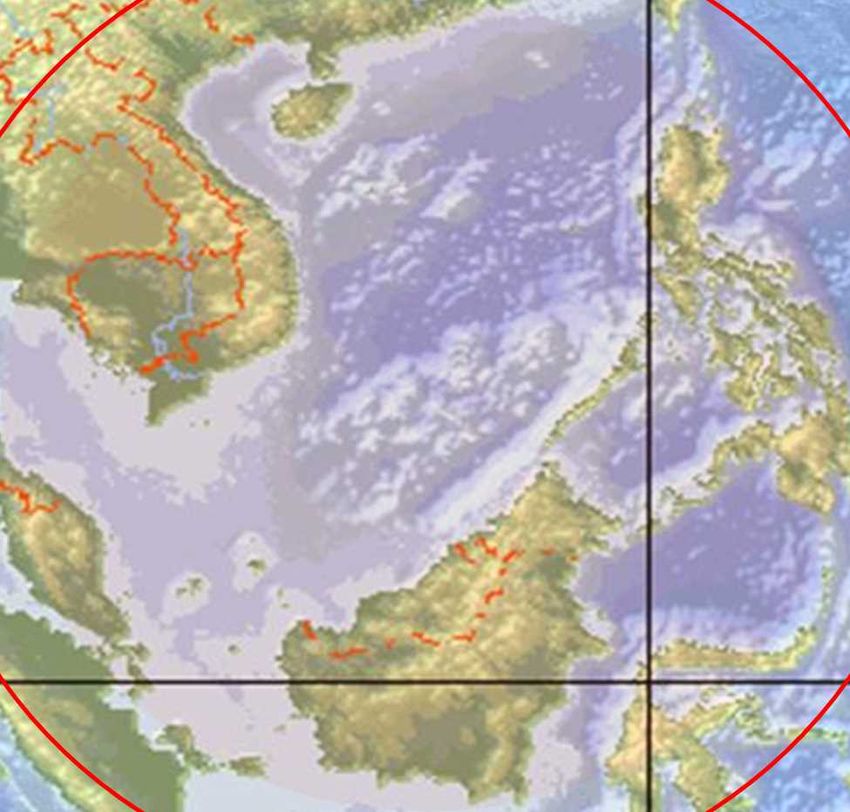
(Summary 3/3) Security Implications
Building port facilities in the SCS could                       Runway construction on the Fiery Cross, Subi, and
dramatically improve China’s ISR and other                      Mischief Reefs (incl. 3,000m-class) would lead to
mission capabilities in the SCS                                 increase in China’s air force presence in the SCS

                                                                                               1500km              Taiwan
                             Paracel Islands                              Su-27/30
                                 Woody Island                                                            “Nine-dash line”
                                                                           Fighters
                   Macclesfield Bank
                                                                                          Vietnam   The SCS
         Vietnam
                                                                  H-6                                                 The Philippines
                                                                                                              Subi Reef
                                        Spratly
                    Subi Reef           Islands
                                                                Bombers                                        Mischief Reef

                                      Gaven Reefs                         1800km
                                       Mischief Reef                                            Fiery Cross Reef
          Fiery Cross Reef
                                      Hughes Reef                         Malaysia              Spratly
            Cuarteron Reef Johnson South Reef
“Nine-dash line”                                                     Malacca Strait             Islands
                                                                      (Approx. 1,400km)

                                                                                          Indonesia
                             Brunei                                        Sunda Strait
     Sea lane       Malaysia                           ※image
                                                                           (Approx. 1,800km)
                                                                                                      Lombok Strait
                         0             500          1,000km      ※image                                 (Approx. 2,000km)
                                                                                                                                   ❸
China's Activities in the South China Sea - China's development activities on the features and trends in related countries
South China Sea

1. China’s Occupation
 in the Spratly Islands
China's Activities in the South China Sea - China's development activities on the features and trends in related countries
1-1 China Makes Advances into the SCS
China has made advances into the SCS by exploiting power vacuums (to the Paracel Islands
in 50s-70s and to the Spratly Islands since 80s.)

                           Timeline
                                                                            China’s                        Pratas Islands
                                                                         advancement
1950s:      France withdraws from French Indochina
                  ↓                                                          1950s
1950s:      China occupies half of the Paracel Islands
           (South Vietnam also advances to Paracel Islands)         Paracel
                  ↓
1973:       U.S. withdraws from South Vietnam                       Islands                                  Scarborough Shoal
                  ↓                                                 Fully occupied
1974:       China occupies the entire Paracel Islands after             in 1974
            dislodging South Vietnam
(1975:Collapse of South Vietnam after the Vietnam War)

Mid-1980s: Soviet military in Vietnam decreases
                ↓                                                                6 features occupied in
1980s:     China advances to the Spratly Islands
1988:      China occupies 6 features of the Spratly Islands         Spratly
                                                                                          1988
                                                                                           ↓                Mischief Reef
                                                                                  Massive reclamation           Occupied in 1995
1992:         U.S. withdraws from the Philippines                   Islands            since 2014
                      ↓                                                                                   Second Thomas Shoal
1995:         China occupies Mischief Reef

2000s:        China advances to the southern SCS                                                            “Nine-dash line”
2012:         China gains de facto control over Scarborough Shoal
                                                                                     South Luconia Shoal
2014-:       China conducts rapid and large-scale reclamation
             and infrastructure building in the SCS                                    James Shoal                                 * image
                                                                                                                                   1,000km
                                                                                                      0                 500
                                                                                                                                         1
China's Activities in the South China Sea - China's development activities on the features and trends in related countries
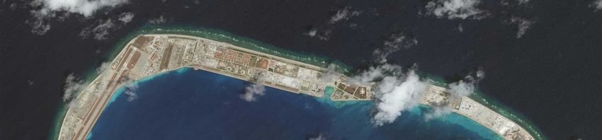
1-2 China’s Occupation in the SCS (before reclamation)
         China gained de facto control over 7 maritime features in the Spratlys and built structures at all of the 7
         features
         Based on its sovereignty claim, China has taken legislative and administrative actions such as the enactment
         of the Law on Territorial Sea (1992), the establishment of Sansha City and the Sansha Security District (2012),
         and the establishment of Xisha and Nansha Districts under Sansha City (2020).
     Structures on features etc.                           1997
        :China’s                                                                 Paracel Islands                         The Philippines
        :Taiwan’s                                                                                Bombay Reef
        :Vietnam’s
        :the Philippines’
                                                                                         Macclesfield Bank
        :Malaysia’s
  ※ Thin dash lines show 200 NM                                 Subi Reef                                          Scarborough
  from coasts geographically
                                                      Gaven Reef                                                      Shoal
                                                                            Vietnam
                                               1990                                                       “Nine-dash line”
              Fiery Cross Reef                                                                                                 Hughes Reef
                                        1988                                                                            1988

                            Cuarteron Reef
                       1991                                Johnson South Reef            Spratly Islands                       Mischief Reef
                                                         1988                                                        1995

                                                                                              Brunei

                                                                                                      0           500                1,000km
        ※ image                                                                       Malaysia
(Ref.) Media reports etc.                                                                                                                      2
China's Activities in the South China Sea - China's development activities on the features and trends in related countries
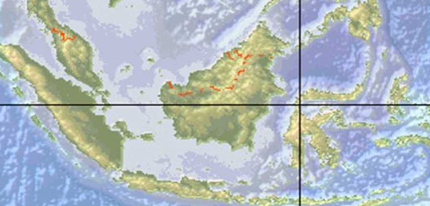
1-3 China’s Occupation in the SCS after Reclamation①
       Since 2013, China has conducted runway extension works at Woody Island in the Paracels.
       Since 2014, China has pressed ahead with rapid and large-scale land reclamation works in 7 features in the Spratlys. By
       the late-2015 when the reclamation had been mostly completed, area of the reclamation work was approx. 12.9 ㎢.
       After the completion of the reclamation, China continues developing infrastructure which can be used for military
       purposes , with further militarization.
                                                          Bombay Reef     Pointed out to be                                                 2,900m-class          Gaven Reefs
      Structures on features etc.
                                                                          info. collection sensor                                           runway; records
        :China’s                                                                                                                            of deployment of                            June 2017
                                                                                                                                                                                   Source:CSIS/AMTI
        :Taiwan’s                                                                 November 2018                                             HQ-9 SAMs, YJ-62
                                                                                     Source:CSIS/AMTI
                                                                                                                        January 2018        ASCMs, and J-11
        :Vietnam’s                                March 2020                                                           Source:CSIS/AMTI     fighters
                                                 Source:CSIS/AMTI
        :the Philippines’                                                                                    Woody Island
        :Malaysia’s
    ※ Thin dash lines show 200 NM                                                                                                                         Gun batteries,
    from coasts geographically
                                                                                                                    Scarborough Shoal                     radar/communication facilities etc.
                                                                                           Paracel                                                              Hughes Reef
           Fiery Cross Reef                               Subi Reef                        Islands                                                                              June 2017
                                                   3,000m-class runway                                                                                                    Source:CSIS/AMTI
                                                   (where test flight                                               No reclamation

                                                   forcibly conducted),
                                                   hangers, and gun
                                                   batteries etc.
                                                                                           Spratly
                                                                                           Islands                                                     Gun batteries,
                                                    Cuarteron Reef
                                                                                                                                                       radar/communication facilities etc.
                               March 2020       October 2017
                             Source:CSIS/AMTI   Source:CSIS/AMTI                Johnson South Reef
                                                                                                        July 2017                    Mischief Reef              Approx. 2,600m runway
    3,000m-class runway (where test                                                             Source:CSIS/AMTI                                                (where test flight forcibly
    flight forcibly conducted), hangers,                                                                                                                        conducted), hangers, and
    and gun batteries etc. Reported to                                                                                                                          gun batteries etc
    be most advanced.

                                             Gun batteries,                     Gun batteries,                                                                   Sources: US DoD Annual
0                   500              1,000km radar/communication                radar/communication                            April 2020                        Report to Congress (2016),
                                             facilities etc.                    facilities etc.                                                                  media reports etc.
                                                                                                                             Source:CSIS/AMTI
                                                                                                                                                                                                  3
China's Activities in the South China Sea - China's development activities on the features and trends in related countries
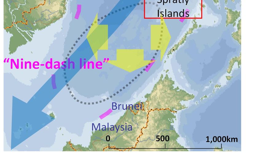
1-4 China’s Reclamation Activities in the SCS (for each feature) ①
January 2014                      1. Johnson South Reef ➊

               Original outpost                                Before reclamation: App. 0.001㎢
                                      (Ref.) CSIS Asia Maritime Transparency Initiative / DigitalGlobe (incl. photo)
                                                                      US DoD Annual Report to Congress 2016

                                                                                                                       4
China's Activities in the South China Sea - China's development activities on the features and trends in related countries
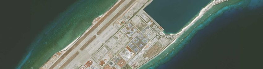
1. Johnson South Reef➋                                                  Descriptions of infrastructure are based
                                                                                                                       on points made by CSIS/AMTI, US DoD
                                                                                                                    annual report to the Congress (2017), and
                                                                                                                                           other open sources.
   July 2017
                                                                                                       After reclamation: App.0.109㎢
                                                                                                      (Reclamation completed in 2014)
              Quay                                                           Radar/communications facility

                                                                                     Helipad                     Gun Battery
  Dredged channel
                                            App.380m
                      Lighthouse
Gun Battery

                                                                 App.320m

  Gun Battery
  砲台                                                                                                          Power generation
                                                                                                                (Solar array)

                                                                                                   Radar/communications facility
                                                    Headquarters
         Original outpost
                  Sources:CSIS Asia Maritime Transparency Initiative (photo) / U.S. DoD Annual Report to Congress 2017 (size) /Google Earth (length)        5
1-4 China’s Reclamation Activities in the SCS (for each feature) ②
                           2. Hughes Reef ➊
February 2010

Original outpost

                                                            Before reclamation: App. 0.001㎢
                                  (Ref.) CSIS Asia Maritime Transparency Initiative / DigitalGlobe (incl. photo)
                                                                     US DoD Annual Report to Congress 2016
                                                                                                                   6
Descriptions of infrastructure are based
                                                 2. Hughes Reef ➋                                                   on points made by CSIS/AMTI, US DoD
                                                                                                                 annual report to the Congress (2017), and
                                                                                                                                        other open sources.

June 2017

                    Helipad                                                      Dredged channel
                                               App.230m
  Original
  outpost                                                                                                          Quay (with a
                                                                 November 2016      Gun Battery                   loading crane)

                                                             November 2016
                                                                               Gun Battery
    November 2016

   Gun Battery                                                                                                App.620m

                           November 2016
                                                                 Helipad
                          Gun Battery                                                          Radar/communications facility

                                     Headquarters                      Radar/communications facility
                                                                                                  After reclamation: App.0.073㎢
                                                                                                 (Reclamation completed in 2014)

                    Sources:CSIS Asia Maritime Transparency Initiative (photo) / U.S. DoD Annual Report to Congress 2017 /Google Earth (length)
                                                                                                                                                        7
1-4 China’s Reclamation Activities in the SCS (for each feature) ③
 March 2013              3. Cuarteron Reef ➊

                                                            Before reclamation: App. 0.001㎢
                                  (Ref.) CSIS Asia Maritime Transparency Initiative / DigitalGlobe (incl. photo)
 Original outpost                                                    US DoD Annual Report to Congress 2016
                                                                                                                   8
Descriptions of infrastructure are based
                                                  3. Cuarteron Reef ➋                                                   on points made by CSIS/AMTI, US DoD
                                                                                                                         annual report to the Congress (2017),
                                                                                                                                       and other open sources.
October 2017
                                                                                                      November 2016

               Dredged channel
                                                                           Lighthouse

                                                                                                                    Gun Battery
     Radar/Communication facility
                                                                             App.650m
                                                                                                       Headquarters
 Quay (with a loading crane)
                                                                                                   Original outpost

                                                                                                           Helipad
                                                                                                                           Multiple poles
                                                                                                                             (HF radar
                                                                                                                            〔possibly〕)
     Gun Battery
                                                                                                        January 2016

                                                                                                After reclamation: App.0.247㎢
                                                                                              (Reclamation completion in 2014)
                                                約330m
         November 2016                                                              Radar/communications facility
               Sources:CSIS Asia Maritime Transparency Initiative (photo) / U.S. DoD Annual Report to Congress 2016 (size) /Google Earth (length) 9
1-4 China’s Reclamation Activities in the SCS (for each feature) ④
                                  4. Gaven Reefs ➊
       March 2014

            Original outpost

                                                         Before reclamation: App. 0.001㎢
                               (Ref.) CSIS Asia Maritime Transparency Initiative / DigitalGlobe (incl. photo)
                                                                  US DoD Annual Report to Congress 2016

                                                                                                                10
4. Gaven Reefs ➋                                               Descriptions of infrastructure are based on
                                                                                                                points made by CSIS/AMTI, US DoD annual
                                                                                                                  report to the Congress (2017), and other
                                                                                                                                              open sources.

      June 2017                Gun battery                                              Helipad

       Gun battery                                 App.450m
        November 2016                                                                   Original outpost
                                 November 2016

                                                                                 Radar/Communication facility
                              App.300m
                                                          Wind turbines
Headquarters
                                                              Gun battery
            App.250m
 Gun battery                                                     Radar/Communication facility

                                                                                                Helipad
           Power generation
             (Solar array)
                                                                                      After reclamation: App.0.146㎢
            Quay (with a loading crane)                                             (Reclamation completion in 2014)
                                 Dredged channel
         Sources:CSIS Asia Maritime Transparency Initiative (photo) / U.S. DoD Annual Report to Congress 2017 /Google Earth (length)
                                                                                                                                                     11
1-4 China’s Reclamation Activities in the SCS (for each feature) ⑤
 August 2014             5. Fiery Cross Reef➊

                                                        Before reclamation: App. 0.010㎢
                               (Ref.) CSIS Asia Maritime Transparency Initiative / DigitalGlobe (incl. photo)
Original outpost                                                  US DoD Annual Report to Congress 2016
                                                                                                                12
Descriptions of infrastructure are based on points
                                                            5. Fiery Cross Reef➋                                          made by CSIS/AMTI, US DoD annual report to the
                                                                                                                                  Congress (2017), and other open sources.

                  March 2020                                                                                                Radar/Sensor Array
                                                                                                                            Hangers (completed)
                                                                                                                            SAM shelters
                 March 2017                          November 2016
                                                                                                                            Gun battery
                                                                                                                           Underground storage facility
                                                                                                                           Runway (completed)

                                                      Gun battery                                                                           Gun battery

                         Hangers                                                       Runway (approx. 3,000m)

                Gun battery      App.3,750m                                                                                                 November 2016

                                                                                                          2017年6月

Gun battery
                November 2016

                                                                           June 2017
November 2016                                                                                        Radar/communications facility

                                                                                                                  After reclamation: App. 2.72㎢
    SAM                                    Underground
                                                                                                                (Reclamation completed in 2015)
    shelters                               storage facility                Radar/communications
                                           (confirmed in June)             facility
            Original outpost    Sources:CSIS Asia Maritime Transparency Initiative (photo) / U.S. DoD Annual Report to Congress 2017 /Google Earth (length)          13
1-4 China’s Reclamation Activities in the SCS (for each feature) ⑥
February 2015               6. Subi Reef➊

                                                                                        Channel

                                                            Before reclamation: App. 0.002㎢
     Original outpost             (Ref.) CSIS Asia Maritime Transparency Initiative / DigitalGlobe (incl. photo)
                                                          US DoD Annual Report to Congress 2016, IHS Jane’s
  (incl. EW radar [est.])
                                                                                                                   14
Descriptions of infrastructure are based on points
                                                        6. Subi Reef➋                                                made by CSIS/AMTI, US DoD annual report to the
                                                                                                                             Congress (2017), and other open sources.

    March 2020
                                                                                                                       Gun battery
   After reclamation: App. 4.11㎢
 (Reclamation completed in 2015)
Radar/Communication facility
                                                                               App.5,500m
Hangers (completed)                                                                                                   November 2016
SAM shelters                                                                     March 2017
Gun battery
                                                                                                                                          Gun battery
Underground storage facility
Runway (completed)

Runway (approx. 3,000m)                                                       Hangers                                    November 2016

   Gun battery                                                                     Radar/Communication facility

                                                                                                                 Channel widened

  November 2016                                      March 2017                                                Radar/Communication facility
                                                                                   2017年12月
                                                                                                                     2017年3月
                                                  Underground
                                                  storage facility                SAM Shelters
                                   App.3,000m                                                                    High-frequency “elephant
                                                                                                                 cage” radar array
Original outpost                                                                                             Gun battery
                                                                                            November 2016

                   Sources:CSIS Asia Maritime Transparency Initiative (photo) / U.S. DoD Annual Report to Congress 2017 /Google Earth (length)                   15
1-4 China’s Reclamation Activities in the SCS (for each feature) ⑦
February 2015              7. Mischief Reef➊

                                                             Before reclamation: App. 0.002㎢
  Original outpost                  (Ref.) CSIS Asia Maritime Transparency Initiative / DigitalGlobe (incl. photo)
                                                                       US DoD Annual Report to Congress 2016
                                                                                                                     16
Descriptions of infrastructure are based on
                                                            7. Mischief Reef➋                                                  points made by CSIS/AMTI, US DoD annual
                                                                                                                                 report to the Congress (2017), and other
      April 2020                                                                                                                                             open sources.

                        Gun battery                                                                                        Radar/Sensor Array
                                                                                                                           Hangers
                                                                                     SAM shelters
                                                                                                                           SAM shelters
                                                                                                                           Gun battery
        November 2016
                                                    November 2020                                                          Underground storage facility
    Runway                                            Aerostat                                                             Runway
                                                       radar                                   November 2016
(approx. 3,000m)
                                      March 2017

                                                                                                                 Gun battery
Gun battery
                                       Hangers                                                                 App.9,000m
November 2016

                                                               App.5,700m                                                       November 2016
 Underground storage
 facility
 (confirmed in June2017)                                            June 2017

                                                                                                                               Gun battery

                                                                                                          After reclamation: App. 5.70㎢
                                                                                                        (Reclamation completed in 2015)
             Original outpost
                                                                    Large antenna array

                           Sources:CSIS Asia Maritime Transparency Initiative (photo) / U.S. DoD Annual Report to Congress 2017 /Google Earth (length)              17
1-5 China’s remarks about the activity on the SCS
Initially, China denied its intentions to pursue militarization, and repeatedly mentioned the
necessity of “defensive facilities”. Recently, government media reports that the reclamation
works are “to strengthen the necessary military defences of the South China sea”
   September 2015 : On his visit to the U.S., President Xi stated “China does
   not intend to pursue militarization” in the SCS.
   February 2016:Foreign Minister Wang Yi said “(As an answer to the
   question regarding a report about the deployment of SAM systems on
   Woody Island, the report is a fake created by some western media, and)
   China’s limited, necessary defense facilities on Nansha (Spratly) Islands
   are in accordance with international law, which endows every sovereign
   state with the rights of self-protection and self-defense. These facilities
   have nothing to do with militarization”
   December 2017:CHINA NANHAI※reported “To strengthen the necessary
   military defense of the South China sea within China’s sovereignty, China
   has rationally expanded the area of its islands and reefs .”
※ CHINA NANHAI(nanhai.haiwainet.cn)is a website jointly run by the National Marine Date and Information
 Service and the People’s Daily Overseas Edition. The website opened in August 2016.                      18
South China Sea

2. Recent activities of PLA
  in the South China Sea
2-1 Recent activities of PLA in the South China Sea①
                                                                                                                                    Ref. CSIS Asia Maritime Transparency
       Points made by CSIS/AMTI (May 9, 2018) and Jane’s Online(May 12, 2020)                                                       Initiative / DigitalGlobe、CNBC、Jane’s Online
    Satellite imagery from April 28 reveals the first image of a military aircraft Y-8, deployed to China’s base at Subi
    Reef(a). With these deployments, military aircraft have now verifiably landed on all of “Big three”.(April 2016, a
    transport aircraft landed at Fiery Cross Reef to evacuate personnel who had fallen ill. A photo in January 2018
    shows two Y-7 military transport aircraft on Mischief Reef (b))
    On April 9, the WSJ published satellite imagery showing military jamming equipment on Mischief Reef (c). The
    article cited a U.S. official who said the jamming systems were deployed to Fiery Cross Reef as well.
    On May 2, CNBC reported that China had deployed YJ-12B anti-ship cruise missiles and HQ-9B surface-to-air
    missile systems on each of the reefs in Spratly island as part of military exercises in early April. This is the first
    confirmed placement of such platforms on the islands.
    On May 12, 2020, Jane’s Online reported that China possibly deployed aircraft including Y-8 patrol and Y-9
    early warning aircraft and other aircraft to the Fiery Cross Reef in rotation(d)
 CSIS/AMTI satellite image                 Philippine Daily Inquirer aerial image                     CSIS/AMTI satellite image         【Vietnamese MOFA Spokesperson
                                                                                                                                        (May 8,2018)】
                                                                                                                                        ”Vietnam is deeply concerned about the
                                                                                                                                        information. All militarized activities,
                                                                                                                                        including the installation of missiles on
                                                                                                                                        Spratly archipelago, seriously violate the
                                                                                                                                        country’s sovereignty over the islands.
                                                                                                                                        The actions cause tension and instability
                                                                                                                                        in the region.”

(a) A Y-8 at the airstrip on Subi Reef,   ( b) Two Y-7s on the apron at Mischief Reef,January ( c ) Military jamming equipment deployed on
April 28, 2018.                           6,2018. (Photo provided byThe Philippine Daily inquirer.) Mischief Reef, May 6, 2018. (under covers)

                                                                            【Ref.】CNBC reported on May2, 2018
                                                               The missile platforms of YJ-12B ASCM and
                                           (d)Z-8, Y-8 and Y-9 HQ-9B SAM were moved to the outposts in
                                           at the airstrip on the Spratly Islands within the past 30 days,                   YJ-12ASCM                 HQ-9SAM
                                                                                                                                          ※
                                           Fiery Cross Reef, according to sources who spoke on the                           (Max range 500km)         (Max range 200km)
                                           May 12, 2020.       condition of anonymity. Pentagon official                     ※YJ-12 was originally developed as an air-to-
                                                               told CNBC “The further militarization of                      ship missile, but recently the development of
                                                               outposts will only serve to raise tensions and                surface launched and ship launched variant is
  Jane’s Online satellite image
                                                               create greater distrust among claimants.”                     pointed out.                                  19
2-1 Recent activities of PLA in the South China Sea②
                                                                                       Ref. CSIS Asia Maritime Transparency Initiative / DigitalGlobe、CNBC、Jane’s Online
Points made by CSIS/AMTI (May 9, 2018)
    Most of China’s recent deployments in the Big three followed a pattern set earlier at Woody Island, its largest
    outpost and administrative seat in the Paracel Islands. From harbor dredging and runway improvements to
    hangar and radar construction, upgrades at Woody Island have served as a blueprint for things to come on
    China’s Spratly holdings to the south. China deployed HQ-9s and anti-ship cruise missiles(YJ-62s) to Woody
    in 2016. Satellite imagery also captured five Y-8 aircraft on the island in November 2017 (a). China has
    repeatedly deployed J-10 and J-11 fighter jets to Woody Island (b). Satellite imagery from April 2016 also
    captured what are believed to be Z-8 helicopters and BZK-005 drone deployed to Woody Island(c) 。

                                                                                    Chinese Detection/ Defense Capabilities in the SCS

               (a) Total five Y-8 on Woody Island,
                 November 15, 2017

                                      (c) A helicopter believed to be a Z-8                                                           Legend
                                        and a drone believed to be a BZK-                                                  OUTPOST
                                                                                                                           Range of YJ-62                Radii of J-10
                                        005 on Woody Island, April 26,
(b) J-11B fighter jets parked on                                                                                           Range of YJ-12B               Rader ranges
                                        2016.                                 【Ref.】YJ-62ASCM(Max range
  Woody Island, April 26, 2016                                                                                             Range of HQ-9                 9-dash line
                                                                                280km)(IHS Jane’s Online)                                                                20
Ref. CSIS Asia Maritime
                      2-1 Recent activities of PLA in the South China Sea③                                                                         Transparency Initiative /
                                                                                                                                                   DigitalGlobe、CNBC、Jane’s
                                                                                                                                                   Online
     On May 18, 2018, China Ministry of Defense announced that PLAF H-6K bombers and other aircraft
   conducted takeoff and landing exercises in “the southern sea area”.
     Then, CSIS/AMTI and Defense News etc. stated that they had identified the location of the excises as
   Woody Island in the Paracels.
     These exercises were the first confirmed case where China landed its bombers on an airstrip on the South
   China Sea features.
【China Ministry of Defense’s comment(May 18, 2018)】                                                        People’s Daily reported the video
“PLAF H-6K bombers improving maritime combat capability through take off and landing exercises on of H-6K conducting takeoff and
islands” :                                                                                                         landing exercises
 A division of the PLAF recently conducted takeoff and landing exercises on islands with organized
various multiple bombers including H-6K and trained to improve “Full Territory, Full-time Assault and
All-round Strike” capabilities. The commander Hao Jianke took the lead in piloting and taking off on an
H-6K bomber from an airfield in the southern area. The division conducted assault training onto targets
on the sea and then performed takeoff and landing exercises at an airfield on an island, achieving the ※Defense News identified the
                                                                                                           location of the excise as Woody
goals of the training and equipping experience of takeoff and landing on islands with the PLAF bomber Island based on this video
units.・・・Focusing on realizing the strategic objectives of “Air and Space Integration, Both Offensive & Philippines and Vietnam
Defensive Operations,” the PLAF is marching towards the modernization of entire-territory-operations
and the transformation into a strategic military service. According to an military expert, Wang Mingliang,
                                                                                                           criticized the issue
the bombers’ deployment to conduct takeoff and landing exercises in the southern sea area contributes to Example of military aircraft that
the improvement of the combat capability in response to the threats on the maritime safety as well as the was deployed in South China Sea
                                                                                                              (based on the classification by
preparation of war and the training of combat capability.                                                  CSIS/AMTI, including presamption)
CSIS/AMTI Analysis on H-6’s Coverage                                                                                                                Y-8( Nobember 2017)
                            H-6 bomber*                            Woody
                                                 *The most
                                                                   Island
                                                 advanced H-6
                                                 variant is H-6K,              J-11fighter(April 2016、March・ Z-8 helicopters and BZK-005
                                                                               Nobember 2017etc.)
                                                 it is pointed out                                           (April 2016 )
                                                                                                             Y-7 military transport aircraft
                           Radius of operation   that its radius of Spratly                                  (January 2018 )                   Y-8(April 2018 )

                                    :1,800km     operation          Islands
                                                 reaches                      Transport aircraft (April 2016,
                                                 3,500km.                     reported to be evacuation of ill
                                                                              people )Fiery Cross Reef                 Mischief Reef                       Subi Reef 21
(Ref.) IHS Jane’s Online,
                  2-2 The commission of the first indigenous CV “Shandong”                                                                             Media reports, etc.

○   In Nov. 2013, the construction of the first indigenous CV started in Dalian, Liaoning Prov.
○   After May 2018, the CV conducted sea trials near Dalian. The CV passed through Taiwan Strait in Nov. 2019.
○   On Dec. 17th 2019, the CV was named “PLA Naval Ship Shandong” at the ceremony in Sanya, Hainan Prov.
○   Reportedly CV “Shandong” is expected to be deployed in Sanya, and will operate in the South China Sea
○   The second indigenous CV is under construction, and the shipyard is reportedly in Shanghai.

Sanya, Hainan Province                           Specification of CV 17 “Shandong” ※ Ref. CV 16 “Liaoning”
                                                                                                                                      (Source: IHS Jane’s Online)
Representation of                CV “Liaoning”                       315m×37m(Max. Width of                                304.5m×37m
locations is approximate.                        Length × Width                                         Length × Width     (Max. Width of the Flight Deck: 70m)
                                                                     the Flight Deck: 70m)
                                                                                                        Displacement       59,439t (Full), (Standard: 46,637t)
                                                 Displacement        66,000t (Full)
                                                                                                        Aircraft           Fighter: J-15×24, Helicopter×12
                                                                     Fighter: J-15×36
                 CV “Liaoning”
                                                                     AEW&C, EW, Helicopter              Take-off           Ski-jump
                                                 Aircraft
             Qingdao, Shandong P.                                    Pointed out to accommodate
                                                                     approx. 40~50 aircraft in total    Power              Steam powered, 30 knots
CV “Shandong”
                                                                                                                           SAM:HHQ-10(18-cell)×4
                                                 Take-off            Ski-jump                           Armament           Gun:30mm Type1130×4 etc.
                            Sanya, Hainan P.     Power               Steam powered                     ・Jul. 2011, China MOD for the first time published its plan
 CV “Shandong”                                                                                                     to repair a second-hand CV.
                                                                (Source: IHS Jane’s Online, etc.)      ・Sep. 2012, the CV, named as “Liaoning,” entered
         Sanya, Hainan P.
                                                                                                                   commission (Qingdao, Shandong Province)
                                                                                                       ・Nov. 2013, CV “Liaoning” conducted a sea trial in the
 (Reported Performance of CV “Shandong”)                                                                           South China Sea for the first time.
  CV “Shandong” utilizes the space under the front part of the flight deck for
                                                                                                       Commander and Political Commissar
  aircraft, while CV “Liaoning” utilizes the space for SSMs, resulting in more
  accommodation of aircraft.                                                                                       Commander of CV “Shandong”
  CV “Shandong” has more operational capability with phased-array radar.                                           LAI Yijuun, Senior Colonel
 (Deployment Reported by China State-Media)
  The commission of CV “Shandong” in Sanya accounts for China’s first                                              Political Commissar of CV “Shandong”
  deployment of a CV in the South China Sea. The deployment will play an                                           ・PANG Jianhong, Senior Colonel
  important role in peace and stability in the South China Sea.
                                         (Source: People’s Daily Net (Dec. 18th 2019), etc.)
 ※ Attendance of the Commission Ceremony: Representatives from related departments of central and state agencies, Central Military Commission,
  PLA Southern Theater, PLA Navy, Hainan Province and construction companies.                                                                                         22
South China Sea
3. Security Implications
by China’s Militarization
 in the Spratly Islands
3-1 Possible Impact of Building Port Facilities in the Spratly Islands
 Building port facilities in the SCS could dramatically improve China’s ISR and other mission
 capabilities in the SCS
                                                                  ・ Building port facilities of certain size capable of
                                                                    berthing, resupply and maintenance would enable
                            Paracel Islands                         China to maintain more robust naval and maritime
                                                                    law enforcement presence in the entire SCS
                                Woody Island
                                                   The
                  Macclesfield Bank
                                                   Philippines    ・ This development would dramatically improve
                                                                    China’s ISR and other mission capabilities in the
        Vietnam                                                     central and southern portions of the SCS
                                       Spratly
                   Subi Reef           Islands                    ・ Some observers refer to considerable impacts on
                                     Gaven Reefs
                                                                    coastal states in the SCS as well as on the sea lane
         Fiery Cross Reef                Mischief Reef
                                     Hughes Reef                         E.g., Fiery Cross Reef
           Cuarteron Reef Johnson South Reef
“Nine-dash line”                                                           June 2016
                                                                           Source:CSIS/AMTI

                            Brunei
                                                                                                                               Harbor
    Sea lane       Malaysia                              ※image

                        0             500             1,000km
                                                                           ※ CSIS/AMTI = CSIS Asia Maritime Transparency Initiative / DigitalGlobe
                                                                                                                                                     23
3-2 Possible Impact of Building Runways in the Spratly Islands
 Runway construction on the Fiery Cross, Subi, and Mischief Reefs (incl. 3,000m-class)
 would lead to increase in China’s air force presence in the SCS
                                                                     ・ The three features with runways and support facilities
                                                                       would enable China to forward-deploy various aerial
                                                                       platforms (incl. fighters, bombers and UAVs)
                         1500km
2000km                                             Taiwan
                                                             ・ In general terms, its ramifications potentially include:
               Su-27/30                                        (1) China’s improved air power-projection capability
                                 “Nine-dash line” over the entire SCS (especially, significant
                          The SCS                                 improvement in China’s ISR and other mission
          UAV Vietnam                                             capabilities in the central and southern portion of
                                             The Philippines      the SCS);
                                   Subi Reef
                                      Mischief Reef            (2) enhanced China’s air superiority over the SCS; and
      H-6
                                                               (3) improved “Anti-Access/Area-Denial” capabilities
       1800km                                                     against the U.S. military presence and its
                      Fiery Cross Reef
                                                                  intervention to contingencies; and
      Malaysia         Spratly
  Malacca Strait                 Islands                             ・ It could lead to possible declaration of an “SCS Air
    (Approx. 1,400 km)                                                 Defense Identification Zone” by China in the future
                                                                       [See.] “Regarding when to declare such a zone [SCS ADIZ], it will depend on whether
                         Indonesia                                     China is facing security threats from the air, and what the level of the air safety
                                                                       threat.” (China Defense Ministry, June 2016)
         Sunda Strait
           (Approx. 1,800km)
                               Lombok Strait
                               (Approx. 2,000km)
                                                            ※image                                                                                      24
South China Sea

4. Situations in Other Related Countries
4-1 Comparison of Navy/Air Force Capabilities (China & the Philippines/Vietnam/Malaysia)
Although main coastal states in the SCS strive to enhance their navy/air force capabilities, a
vast gap with China remains both qualitatively and quantitatively
 (#)                                                                                                                                                                                       ※Excluding aircraft of coast guards
                          Combat Aircraft                                                                                                      (10 thous. tons)            Warship                                          (#)
                       ※Excluding aircraft of coast guards
                                                                                                           China
                                                                                                                                                                                        Gross tonnage
                                                                                                                                                                                        Number of warships

                                                                                                            The Philippines
                                                                                                Vietnam

                                                                                       Malaysia

                                                  China                                         Vietnam                                     Malaysia                                   The Philippines

Warship                    748 (1,97.3 thous. ton)                                159 (8.1 thous. ton)                        77 (8.3 thous. ton)                            121 (6.3 thous. ton)
                       Shang-class (6,100t) x 6                                 Kilo-class (3,100t) x 6                   Scorpene-class (1,800t) x 2                      Null
        Submarine      Yuan-class (3,600t) x 17              ※1:14年までにさら        Yugo-class (100t) x 2
                       Kilo-class (3,100t) x 12 etc.         に1隻が就役した見
                                                             込み
                       Luyang III-class DDG (6,000t) x 11                       Gepard-class  FFG (1,600t) x 4
                                                                                 ※4:15年7月までにさらに2隻を追加配備                    Lekiu-class FF (1,800t) x 2              Hamilton-class FF (2,700t) x 3
        Destroyer/
                       Jiankai II-class FFG (3,600t) x 29 etc.                  Petya-class FFL (1,000t) x 5              Kasturi-class Corvette (1,800t) x 2 etc. Auk-class Corvette (1,100t) x 2 etc.
        Frigate etc.

Combat Aircraft          3,015 (incl. 4th/5th generation fighter x 1,080)        72 (incl. 4th generation fighter x 46)    69 (incl. 4th generation fighter x 36)          43(incl. 4th generation fighter x 12)
                       J-10 x 468                                               Su-30MK2 x 35                             Su-30MKM x 18                                    FA-50PH x 12
          Fighter      Su-27/J-11 x 349                                         Su-27 x 11                                F/A-18 x 8 etc.
                       Su-30 x 97 etc.                                          Su-22 x 26 etc.
         Patrol aircraft KJ-2000AEW&C x 4                                       Null                                      Null                                             F-27-200MPAx 1
       (fixed-wing) etc. KJ-500AEW&C x 11 etc.                                                                                                                             N-22SLx 1 etc.
  Marines etc.               Approx. 25,000 (PLA Marine Corps)                              Approx. 27,000                                     Null                                     Approx. 8,300
                       523+ (China Coast Guard)                                 69+ (Coast Guard)                         127 (Malaysia Maritime Enforcement Agency) 86 (Coast Guard)
                       ≧1,500t x 87※        ※:including 10,000t-class CCG       ≧1,500t x 4                               ≧1,500t x 4                                 ≦1,500 x 7 etc.
Patrol and coastal                              vessels, the largest class in
                       500≦,
4-2 Development Trends of Other Countries/Regions in the SCS
  Vietnam, the Philippines, Malaysia, and Taiwan in the 80s/90s built runways (600-1,200m) on the
  land features over which they have de facto control. All of them have done facility maintenance and
  development. Reports suggest that Vietnam has recently conducted reclamation work.
    Structures on features etc.
                                                 October 2011
                                                  Source:CSIS/AMTI           Sand Cay (V)                                                                                           * CSIS/AMTI points out that Vietnam
                                                                                                                                                                                    reclaimed 486,000 square meters in 10
      :China’s                                                                These satellite photos indicate            Paracel                                                    features in total in 2 years since 2014.
                                                                              the reclamation area was
      :Taiwan’s                                                               approx. 37,190 ㎡                           Islands
                                                                                                                                                             In 2011, a plan to repair the runway announced; in January
      :Vietnam’s                                                              Sin Cowe Island (V)                                  Approx. 1,200m runway     2016, a plan to implement a civilian aircraft tracking system

      :the Philippines’                                                           These satellite photos indicate the              Thitu Island (P)                                                  Itu Aba Island (T)
                                                                                  reclamation area was approx.
      :Malaysia’s                                                                 105,501 ㎡
※ Thin dash lines show 200 NM                                                 February 2006                  September 2016                                      Approx. 1,200m runway
from coasts geographically                                                    Source:CSIS/AMTI               Source:CSIS/AMTI

                                                 Source:CSIS/AMTI
        March 2013                               August 2016
        Source:CSIS/AMTI                                                                                                                                                                                 Airfield infrastructure
                                                                                                                                                                                                         expanded

                                                                                                                                                                                      Harbor expansion
                                            West London Reef (V)                                                                                                                      completed in Dec. 2015
                                                                                                                                                                                                                      May 2016
                                            These satellite photos indicate the                                                                                                                        Sources:CSIS/AMTI, IHS Jane’s
                                            reclamation area was approx.                                                                                        A lighthouse (height: 12.7m) completed in October 2015;
                                            285,303 ㎡                                                                                                           harbor expansion completed in December 2015, in which
                                                                                                                                                                3,000t-class vessels can berth
                                  Approx.                            Spratly Island (V)
                                   162m
                                                         These satellite photos indicate the reclamation                                                 Swallow Reef (M)
        Approx.
         494m
                                                         area was approx. 150,502 ㎡; runway
                                                         extended to 1,000m-class; large hangers built
                                                                                                                        Spratly Islands                        Approx. 1,400m runway

                                                                                                                                    Brunei
       Source:CSIS/AMTI                                                                                                                                                            Runway extended in 2003
       April 2016                                                                                                        “Nine-dash line”                                          (from 1,000m to 1,400m)

                                                       Approx. 600m runway                          Source:CSIS/AMTI
                                                                                                                           Malaysia            0                             500                          1,000km
          ※ image                                      May 2014                                 November 2016
(Sources: CSIS/AMTI, media reports)                                                                                                                ※CSIS/AMTI = CSIS Asia Maritime Transparency Initiative / DigitalGlobe          26
4-3 The abstract of the Award of the SCS Arbitration (1)

Abstract
○ On 12th July 2016, the Tribunal, in the South China Sea Arbitration, issued an Award. The Tribunal
 concluded that China’s ‘nine-dash line’ is invalid, that none of the features in the Spratly Islands are fully
 entitled islands, which is capable of generating extended maritime zones, that China had violated the
 Philippines’ sovereign rights, and that China had caused severe harm to marine environment, resulting in
 agreement with the majority of Philippines’ claims.
○ “The award shall be final,” and “shall be complied with by the parties to the dispute.”

 Historic Rights and the ‘Nine-Dash Line’

○ The Tribunal concluded that historical navigation and fishing by China in the waters of the South China
 Sea represented the exercise of high seas freedoms, rather than a historic right, and that there was no
 evidence that China had historically exercised exclusive control over the waters of the South China Sea
 or prevented other States from exploiting their resources.
○ The Tribunal concluded that there was no legal basis for China to claim historic rights to resources
 within the sea areas falling within the ‘nine-dash line.’

                                                                                                                  27
4-3 The abstract of the Award of the SCS Arbitration (2)
  Status of Features
○ Under the UN Convention on the Law of the Sea, “rocks which cannot sustain human habitation or economic
 life of their own shall have no exclusive economic zone or continental shelf.” The Tribunal concluded that this
 provision depends upon the objective capacity of a feature, in its natural condition, to sustain either a stable
 community of people or economic activity that is not dependent on outside resources.
○ The Tribunal concluded that Scarborough Shoal, Johnson Reef, Cuarteron Reef, Fiery Cross Reef, Gaven Reef
 (North) and McKennan Reef are high-tide features and that Subi Reef, Hughes Reef, Mischief Reef, and Second
 Thomas Shoal were submerged at high tide in their natural condition.
○ The Tribunal concluded that all of the high-tide features in the Spratly Islands (including, for example, Itu Aba,
 Thitu, West York Island, Spratly Island, North-East Cay, South-West Cay) are legally “rocks” that do not generate
 an exclusive economic zone or continental shelf.

 Lawfulness of Chinese Actions / Harm to Marine Environment
○ The Tribunal found that China had violated the Philippines’ sovereign rights in its exclusive economic zone by
 such means as interfering with Philippine fishing and petroleum exploration and constructing artificial islands.
 The Tribunal also held that China had interfered with traditional fishing rights of fishermen from the Philippines
 at Scarborough Shoal in restricting access. The Tribunal further held that Chinese law enforcement vessels had
 unlawfully created a serious risk of collision when they physically obstructed Philippine vessels.
○ The Tribunal found that China’s recent large scale land reclamation and construction of artificial islands at
 seven features in the Spratly Islands has caused severe harm to the coral reef environment. The Tribunal found,
 however, that China’s recent large-scale land reclamation and construction of artificial islands was
 incompatible with the obligations on a State during dispute resolution proceedings
* The Tribunal found that it lacked jurisdiction to consider the implications of a stand-off between Philippine and China at Second Thomas Shoal.

                                                                                                                                                    28
4-4 Trends in China and reactions of other countries and region since the COVID-19 outbreak(1)
① In February 2020, a Chinese naval vessel directed radar at a Philippine naval vessel.
[Others’ Response] The Philippines lodged diplomatic protest against China.
② In April 2020, a Vietnamese fishing boat collided with a Chinese Coastguard vessel and sank in the waters of the Paracel Islands.
[Others’ Response] Vietnam lodged diplomatic protest against China. The Philippines also expressed concerns. (The Philippines experienced a similar case in June 2019.)
③ In April 2020, the “Liaoning” aircraft carrier group passed through the Miyako Strait, Bashi Channel and entered the South China Sea.
[Others’ Response] Taiwan’s Ministry of National Defense announced the above.
④ In April 2020, China announced the new establishment of “Xisha and Nansha Districts” in the South China Sea.
[Others’ Response] A spokesperson of the Vietnam’s Foreign Ministry remarked that China’s acts violate Vietnam’s sovereignty, and the Philippines protested as well.
⑤ In April 2020, a Chinese survey ship “Haiyang Dizhi 8” operated near the Malaysian drillship “West Capella.” (Image 1)
[Others’ Response] While avoiding explicit protests, Malaysia’s Foreign Minister remarked that the presence of warships and other naval vessels in the South China Sea
   could increase tensions and undermine peace, security and stability.
⑥ From July 1 to 5, 2020, PLA Navy conducted military exercise near the Paracel Islands. (Advance notice on June 28) (Image 2)
[Others’ Response] A spokesperson of the Vietnam’s Foreign Ministry remarked that China’s drill violated Vietnam’s sovereignty, and the Philippine’s Foreign Minister
   uploaded a video statement showing concerns.
[The U.S.] The U.S. DoD expressed concern that China’s military exercise would destabilize the situation in the South China Sea.
⑦ In August 2020, PLA conducted military exercise in the South China Sea. (According to reports, four medium-range ballistic missiles launched)
[Others’ Response ] ] A spokesperson of the Vietnam’s Foreign Ministry remarked “China’s drill violates Vietnam’s sovereignty in the Paracel Islands.”
[The U.S.]The U.S. DoD expressed concern about the Chinese military exercise and the launch of ballistic missiles in the South China Sea.
⑧ In September 2020, PLA noticed military exercise in the South China Sea.
The U.S. DoS released a press statement to the effect that despite the Xi’s promise five years ago, China uses militarized outposts as platforms of coercion.

                                                            Image 2   China        Taiwan
   Haiyang Dizhi 8                             Image 1                                            【 Details of Exercise (環球時報 (2020.7.4)) 】
                                                                                                  <Sea Areas in the South China Sea>
                                                                              Bashi Channel
                                                                                                  ・Type 052D missile destroyer “Hohhot”(Luyang III-class) locked on to the “enemy ship” and succeeded
  West Capella
                                                                                                    in sinking it by the rapid target conversion and tracking method of the main gun system.
                                                            Vietnam
                                                                                                  ・Type 054A frigate “Yulin”(Jiangkai II-class) fired several jamming rounds at the fast-approaching target
                                                                         Paracel
                                                                         Islands
                                                                                                    and evaded “missile” by Yulin’s covering.
                                Haiyang Dizhi 8
                                                                                    The                                      7,500 tons (full load)                               3,963 tons (full load)
                               Brunei                                   Spratly     Philippines
                               continental                              Islands                                              157.0×17.0×6.0m                                      134.0×16.0×5.0m
          Malaysia continental shelf claim                                                                                                                                        27 knot
          shelf claim                                                                                                        30 knot
                                                                  Maritime Exclusion Zone                                                                                         29 vessels
        (April 13-28, 2020)       Brunei                                                                                     13 vessels
                                                                       【July 1-5, 2020】
  (Sources: CSIS Asia Maritime Transparency Initiative)                                           Luyang III-class destroyer
                                                          「ImageSat International」 が20年4月20日にTwitterに投稿した衛星画像                                         Jiangkai II-class frigate                            29
4-4 Trends in China and reactions of the U.S. and Australia since the COVID-19 outbreak(2)
○ China continues to intensify activities in the South China Sea after the COVID-19 outbreak.
○ On July 13, 2020, the U.S. announced the statement of Secretary of State “U.S. Position on Maritime
 Claims in the South China Sea.”
○ On July 26, 2020, Australia backed the U.S. by sending a letter to the UN denying China’s sovereignty
 claims in the South China Sea.

     The U.S.                 ○ Beijing’s claims to offshore resources across most of the South China Sea are completely unlawful.
                              ○ The U.S. shares deep and abiding interests of the peace and stability, freedom of the seas in a manner consistent with
                                international law, the unimpeded flow of commerce, and opposition to using coercion or force to settle disputes with our
                                allies and partners. These shared interests have come under unprecedented threat from the People’s Republic of China
                                (PRC).
                              ○ Beijing uses intimidation to undermine the sovereign rights of Southeast Asian coastal states in the South China Sea, bully
                                them out of offshore resources, assert unilateral dominion, and replace international law with “might makes right.”
                              ○ The PRC has no legal grounds to unilaterally impose its will on the region. In a unanimous decision on July 12, 2016, an
                                Arbitral Tribunal rejected the PRC’s maritime claims as having no basis in international law.
                              ○ The world will not allow Beijing to treat the South China Sea as its maritime empire. America stands with our Southeast
   US Secretary of State,
         Pompeo                 Asian allies and partners in protecting their sovereign rights to offshore resources, consistent with their rights and
                                obligations under international law. We stand with the international community in defense of freedom of the seas and
                                respect for sovereignty and reject any push to impose “might makes right” in the South China Sea or the wider region.

    Australia

                              ○ The Australian Government rejects any claims by China that are inconsistent with the 1982 United Nations Convention on
                                the Law of the Sea (UNCLOS).
                              ○ Australia rejects China’s claim to ‘historic rights’ or ‘maritime rights and interests’ as established in the Tong course of
                                historical practice’ in the South China Sea. The Tribunal in the 2016 South China Sea Arbitral Award found these claims to
                                be inconsistent with UNCLOS and, to the extent of that inconsistency, invalid.
                              ○ The Australian Government does not accept China’s assertion in its note of 17 April 2020 that its sovereignty claims over
                                the Paracel Islands and the Spratly Islands are ‘widely recognized by the international community.’
  Australia Prime Minister,
          Morrison                                                                                                                                        30
4-5 Efforts of the U.S. and other countries in the SCS
                                                                                                                                                                                                                                       (Ref.) Media reports
PLA and Maritime Law Enforcement Forces (MLEFs):                                                                                                     The U.S. concerns:
● improve ISR and other mission capabilities with port                                                                                               ● inhibition of freedom of navigation in the SLOC
  and runway construction and with sustained                                                                                                         ● constraints of the U.S. military activities
  deployment of vessels and aircraft in the SCS                                                                                                      ● deterioration of security environment in the entire region
● improve A2/AD capabilities against U.S. intervention                                                                                               ⇒ The U.S. requires China to comply with international norms, and criticizes China’s
                                                                                                                                                       unilateral and assertive actions in the SCS.
U.S.-Vietnam Relations                                [Major Military Base]
                                                                                 ✈     : Air Base,         : Naval Base etc.

○ In December 2013, the U.S.
                                                          : Features on which China constructs structures                                          The U.S. strengthens relations with the SCS neighboring countries
 Secretary of State John Kerry                            : Features where China’s vessels allegedly obstructed other ships
 expressed 18-million-dollar support
 for Vietnam in the field of maritime
                                                    In January 2016 and July 2017, U.S. Navy allegedly                                            ● In June 2019, USDOD published Indo-Pacific Strategy Report:
 security ( purchase of 4 patrol
                                                    conducted the “Freedom of Navigation Operation,” sailing
                                                    within 12NM of the Triton Island. In October 2016 and                                            The report states its policies to strengthen the alliance with the Philippines and to
 boats)
○ In November 2015, the U.S.
                                                    October 2017, sailing near the Paracel Islands.
                                                                                                                                                   prioritize new relationship with Vietnam, Indonesia and Malaysia locating
 expressed approximately 40-million-                                           Paracel                                     Subic Bay               strategically key SLOC.
 dollar support for Vietnam in the                                             Islands
 next two years                                          ✈                                     Scarborough Shoal
                                                                                    Triton Island
                                                                                                                                                   ・ with the Philippines: Cooperation on capacity building in various fields such as maritime
○ In May 2016, the U.S. announced it
 was fully lifting the arms embargo to         Vietnam                                                                             ✈                   security and ISR
 Vietnam.                                                                                                                          Clark           ・ with Vietnam: USDOD is building Strategic Partnership with Vietnam that is based on
○ In August 2017, port call by one of
                                                                                                                Philippines                            common interests and principles. The US-Vietnam defense relationship has grown
 the U.S. CVs in 2018 was agreed.
○ In March 2018, a US carrier made a                          ✈          Subi Reef
                                                                                                                                                       dramatically over the past several years.
 port-call at Da Nang (First time after
 Vietnam War)                                     Cam Ranh Bay                                Second Thomas Shoal
                                                                                                                                                   ・ with Indonesia: the Strategic Partnership focuses on six areas for advancing defense
                                                                                                                                                       cooperation such as maritime security and domain awareness.
                                                    ✈                                                                      Palawan
○ In March 2019, a US carrier made a
 port-call at Da Nang (Second time                             Fiery Cross Reef
 since March 2018)                                                                                                         Island                  ・ with Malaysia: USDOD helps Malaysia in fields such as improvement of its MDA by providing
○ In November 2019, Secretary of                                                                                     ✈                                 sensors on existing platforms.
 Defense Esper visited Vietnam,                                                   Spratly
 expressing the grant of a patrol ship
                                                                                  Islands                                                                               The U.S. expands its military presence
                                                                     South Luconia Shoal                                                          ● Expanding the U.S. military presence by increasing port calls of naval vessels,
                           Australian Air Force                                                                                                     reinforcing ISR activities, conducting various joint military trainings, strengthening unit
        ✈ ✈
Butterworth
                             uses as a base                                                    ✈ Malaysia                                           deployment (of vessels such as aircraft carrier, and aircraft) etc.
                                                                                             Labuan                                               ・ Making the enhancement of maritime domain awareness (MDA) the urgent task in the SCS, the U.S.
              ✈Relations
U.S.-Philippines                                           James Shoal                                                                             forces themselves actively conduct ISR activities
                                                                                                                                                    ⇒ The U.S. expects the role of allies such as Japan and Australia (Australia has already conducted
○ In December 2013, the U.S. expressed 40-million-dollar support for the Philippines in order to strengthen its maritime security and its anti-
  terrorism capability                                                                                                                                 operations around the SCS using Butterworth (in Malaysia) as a base)
○ In April 2014, the U.S. and the Philippines signed the Enhanced Defense Cooperation Agreement (EDCA) (*Its constitutionality is currently on    ・ The U.S. deploys littoral combat ships (LCS) in Singapore (since April 2013) and it also deployed maritime
  trial at the Philippine Supreme Court)
  ⇒ The EDCA will make it possible for the U.S. forces to deploy rotationally to military bases in the Philippines                                 patrol aircraft P-8 (December 2015) in Singapore and aircraft such as attack aircraft and electronic-
○ In November 2015, U.S. President Obama expressed 79-million-dollar support as well as the grant of one U.S. Coast Guard Cutter and one           warfare aircraft in the Philippines (since March 2016).
  research vessel for the Philippines
○ In March 2016, the U.S. and the Philippines agreed on 5 base locations under EDCA.                                                              ● The U.S. conducts “Freedom of Navigation Operations (FONOPs)”in order to counter
○ In September 2017, the Chief of Staff of the Philippines announced that the U.S. would begin facilities construction at all of the five EDCA
  base locations.
                                                                                                                                                    excessive maritime claims
○ In March 2019, US Secretary of State Pompeo stated that any armed attack on any Philippine forces, aircraft, or public vessels in the SCS        ・ “We will continue to fly, sail, and operate wherever international law allows, and demonstrate resolve
  would trigger mutual defense obligations.
○ In February 2020, Philippines Secretary of Foreign Affairs Locsin notified the termination of VFA with the U.S. (In June 2020, the                  through operational presence in the South China Sea and beyond.” (Defense Secretary Mattis [June
  termination was suspended)                                                                                                                          2017] etc.)                                                                                      31
4-6 U.S. “Freedom of Navigation Operation (FONOP)”
                                                     (Ref.) U.S. DoD, U.S. Senate Committee on Armed Services etc.

1. Characterization of the “FONOP”
○ “FONOP” is one of the means for carrying out “Freedom of Navigation
  (FON) Program”
 FON Program is characterized as below:
  Ends: In order to preserve the rights, freedoms, and lawful uses of the
      sea and airspace guaranteed to all states under international law by
      demonstrating a non-acquiescence to excessive maritime claims
      asserted by coastal states
  Ways: (1) Operational activities by U.S. military forces / DoD (i.e.,
       “FONOP”)
       (2) Consultations and representations by U.S. DoS
  History: The FON Program has been continuously carried out since 1979.

                                                                                                            32
4-6 U.S. “Freedom of Navigation Operation (FONOP)”
2. Manner of “FONOP” [news report etc.]                                                                                 (Ref.) U.S. DoD, U.S. Senate Committee on Armed Services etc.

○ In May 2015, the U.S. Secretary of Defense Ash Carter said: “ The U.S. will fly, sail and operate wherever international law allows.”
○ According to the U.S. DoD “Asia-Pacific Maritime Security Strategy” (August 2015), “U.S. PACOM maintains a robust shaping presence in and around the SCS, with
  activities ranging from training and exercises with allies and partners to port calls to FONOPs and other routine operations” and “[a]s part of the Department’s
  routine presence activities, the U.S. Navy, U.S. Air Force, and U.S. Coast Guard conduct FONOPs.”
○ In October 2015, the U.S. Navy conducted the “FONOP” within 12NM of the Subi Reef, the Spratly Islands (USS Lassen).
○ In November 2015, PACOM commander Harry Harris said that the U.S. has been, and will be, conducting “FONOPs” in the SCS.
○ In January 2016, the U.S. conducted the “FONOP” within 12NM of the Triton Island, the Paracel Islands (USS Curtis Wilbur). The U.S. Office of Secretary of Defense
  stated: “This operation was about challenging excessive maritime claims that restrict the rights and freedoms of the U.S. and other, not about territorial claims to
  land features. The U.S. takes no position on competing sovereignty claims between the parties to naturally-formed land features in the SCS.”
○ In May 2016, the U.S. Navy conducted the “FONOP” within 12NM of the Fiery Cross Reef (USS William P. Lawrence).
○ In October 2016, the U.S. Navy conducted the “FONOP” near the Paracel Islands (USS Decatur).
○ In May 2017, the U.S. Navy conducted the “FONOP” within 12NM of the Mischief Reef (USS Dewey).
○ In July 2017, the U.S. Navy conducted the “FONOP” within 12NM of the Triton Island, the Paracel Islands (USS Stetham).
○ In August 2017, the U.S. Navy conducted the “FONOP” within 12NM of the Mischief Reef (USS John S. McCain).
○ In October 2017, the U.S. Navy conducted the “FONOP” near the Paracel Islands (USS Chafee).
○ In January 2018, the U.S. Navy conducted the “FONOP” within 12NM of the Scarborough Shoal (USS Hopper).
○ In March 2018, the U.S. Navy conducted the “FONOP” within 12NM of the Mischief Reef (USS Mustin).
○ In May 2018, the U.S. Navy conducted the “FONOP” within 12NM of the Paracel Islands (USS Higgins and Antietam).
○ In September 2018, the U.S. Navy conducted the “FONOP” within 12NM of the Gaven Reef and Johnson South Reef,the Spratly Islands (USS Decatur).
○ In November 2018, the U.S. Navy conducted the “FONOP” near the Paracel Islands(USS Chancellorsville).
○ In January 2019, the U.S. Navy conducted the “FONOP” within 12NM of the Tree, Lincoln and Woody Island, the Spratly Islands (USS McCampbell).
○ In February 2019, the U.S. Navy conducted the “FONOP ” within 12NM of the Mischief Reef (USS Spruance and Preble).
○ In May 2019, the U.S. Navy conducted the “FONOP ” within 12NM of the Gaven and Johnson South Reefs (USS Preble and Chung-Hoon).
○ In May 2019, the U.S. Navy conducted the “FONOP ” within 12NM of the Scarborough Shoal (USS Preble).
○ In August 2019, the U.S. Navy conducted the “FONOP” within 12NM of the Fiery Cross Reef and the Mischief Reef (USS Wayne E Meyer).
○ In September 2019, the U.S. Navy conducted the “FONOP” near the Paracel Islands (USS Wayne E Meyer).
○ In November 2019, the U.S. Navy conducted the “FONOP ” within 12NM of the Mischief Reef (USS Gabrielle Giffords).
○ In November 2019, the U.S. Navy conducted the “FONOP” near the Paracel Islands (USS Wayne E Meyer).
○ In January 2020, the U.S. Navy conducted the “FONOP” near Fiery Cross Reef (USS Montgomery).
○ In March 2020, the U.S. Navy conducted the “FONOP” near the Paracel Islands (USS McCampbell).
○ In April 2020, the U.S. Navy conducted the “FONOP” near the Paracel Islands (USS Barry).
○ In April 2020, the U.S. Navy conducted the “FONOP” within 12NM of the Gaven Reef (USS Bunker Hill).
○ In May 2020, the U.S. Navy conducted the “FONOP” near the Paracel Islands (USS Mustin).
○ In July 2020, the U.S. Navy conducted the “FONOP” within 12NM of the Paracel Islands (USS Ralph Johnson).
○ In August 2020, the U.S. Navy conducted the “FONOP” near the Paracel Islands (USS Mustin).
○ In October 2020, the U.S. Navy conducted the “FONOP” near the Paracel Islands (USS John S. McCain).
○ In December 2020, the U.S. Navy conducted the “FONOP” near the Spratly Islands (USS John S. McCain).
○ In February 2021, the U.S. Navy conducted the “FONOP” near the Paracel Islands (USS John S. McCain).
○ In February 2021, the U.S. Navy conducted the “FONOP” near the Spratly Islands (USS Russell).                                                                                 33」
You can also read