City of Hancock Non-motorized Transportation Network Plan 2017- 2021
←
→
Page content transcription
If your browser does not render page correctly, please read the page content below
City
of
Hancock
Non-‐motorized
Transportation
Network
Plan
2017-‐2021
City
of
Hancock
|
399
Quincy
St.
|
Hancock,
Michigan
49930
Plan
prepared
by:
City
of
Hancock
Bike
&
Pedestrian
Committee
Adopted:
15
March
2017
Table
of
Contents
I.
Introduction
1
Purpose
1
Vision
Statement
1
Overview
of
Hancock
by
Foot
or
Bike
2
Hancock
Bike
and
Pedestrian
Committee
and
the
Planning
Process
3
II.
Existing
Use
Patterns
and
Challenges
4
Findings
of
Surveys,
Public
Meetings
and
Planning
Groups
4
2013
Bike
Initiative
Keweenaw
Survey
4
2014
Hancock
Non-‐motorized
Survey
6
Public
Meetings
14
Safe
Routes
to
School
and
Youth
Destinations
15
Michigan
Tech
Civil
Engineering
Class
Projects
16
MDOT
Training
Wheels
Course
17
Summary
of
Identified
Challenges
18
III.
Network
Development
Plan
21
Plan
Goals
21
Engineering
Objectives
and
Prioritized
Projects
21
Non-‐Engineering
Objectives
and
Strategies
28
Education
and
Encouragement
28
Enforcement
and
Equity
29
Evaluation
and
Planning
29
Implementation
Strategy
30
IV.
Appendices
33-‐104
Appendix
A.
City
of
Hancock
Complete
Streets
Ordinance
Appendix
B.
2013
Houghton
and
Hancock
Bike
and
Pedestrian
Survey
Report
Appendix
C.
Map
of
Problem
Crossings
in
the
City
of
Hancock
Appendix
D.
Summary
of
Key
findings
from
2011
MTU
Complete
Streets
Proposed
Plans
Appendix
E.
2016
MDOT
Training
Wheels
Course
presentation
slides
City
of
Hancock
Non-‐motorized
Transportation
Network
Plan
|
2017-‐2021
I.
Introduction
Purpose
The
City
of
Hancock
Non-‐Motorized
Transportation
Network
Plan,
in
accordance
with
the
City’s
Complete
Streets
Ordinance
adopted
in
April
2014
(Appendix
A),
serves
as
a
framework
for
planning,
construction,
renovation
and
maintenance
of
the
local
comprehensive
transportation
network
from
the
point
of
view
of
all
users,
including
pedestrians,
cyclists
and
transit
users,
with
a
focus
on
safety
and
convenience
for
non-‐motorized
users
of
the
City’s
highways,
roads,
sidewalks,
bike
routes
and
off-‐road
trails.
This
Plan
shall
be
a
living
document
reviewed
at
least
annually
by
the
Hancock
Bike
and
Pedestrian
Committee,
with
updates
recommended
as
needed
to
the
Hancock
Planning
Commission
and
City
Council.
City
officials
shall
review
the
Plan
when
considering
new
roadway
construction
or
renovations
by
the
City,
State
or
other
entities
to
ensure
that
the
needs
of
all
users
are
considered
in
the
context
of
the
broader
transportation
network.
In
accordance
with
the
principles
of
Complete
Streets,
new
roads
and
renovations
shall
serve
to
improve
safety
for
all
users
to
the
extent
practical,
and
enhance
routes
and
connections
for
pedestrians
and
cyclists
to
reach
common
destinations
like
worksites,
schools
and
universities,
shopping,
parks,
and
places
of
worship.
A
continuing
focus
on
Safe
Routes
to
School,
with
its
6E’s
process
–
Engineering,
Education,
Encouragement,
Enforcement,
Equity,
and
Evaluation
–
shall
ensure
that
support
for
safe
walking
and
biking
to
school
is
a
Hancock
priority.
Vision
Statement
Hancock
will
become
a
more
walkable
and
bikeable
community
where
non-‐
motorized
transportation
is
a
safe,
convenient
and
pleasurable
option
for
residents
and
visitors
of
all
ages
and
abilities,
in
all
seasons
and
to
all
destinations.
Page
1
City
of
Hancock
Non-‐motorized
Transportation
Network
Plan
|
2017-‐2021
Overview
of
Hancock
by
Foot
or
Bike
Hancock
is
a
city
in
Houghton
County,
Michigan,
established
during
the
19th
century
copper
boom
and
incorporated
in
1903.
The
City,
with
a
population
of
4,634
(U.S.
Census
2010)
and
a
land
area
of
2.60
square
miles,
is
built
upon
the
hills
that
rise
from
the
north
shore
of
the
Portage
Waterway.
The
hilly
terrain
and
abundant
snow,
averaging
200-‐300
inches
per
year,
are
factors
that
pose
challenges
to
pedestrians
and
cyclists.
In
the
2010
Census,
Hancock
had
1,882
households
of
which
21.4
percent
had
children
under
the
age
of
18
living
with
them,
and
13
percent
had
someone
living
alone
who
was
65
years
of
age
or
older.
The
median
age
in
the
city
was
34.1
years:
16.7
percent
of
residents
were
under
the
age
of
18;
21.8
percent
were
between
the
ages
of
18
and
24
(many
of
them
students
at
Finlandia
University
in
Hancock
or
Michigan
Tech
University
in
nearby
Houghton);
20.8
percent
were
from
25
to
44;
21.5
percent
were
from
45
to
64;
and
19.3
percent
were
65
years
of
age
or
older
(compared
with
about
15
percent
age
65-‐plus
in
state
and
national
tallies).
Nationally,
an
estimated
30
percent
of
people
do
not
have
a
driver’s
license,
for
reasons
including
age
(young
or
old),
health
or
handicap,
poverty,
legal
restriction,
or
choice/preference.
Among
Hancock
residents,
the
percentage
of
non-‐drivers
is
likely
closer
to
40
given
the
population
makeup
including
relatively
large
cohorts
of
seniors,
students
and
low-‐
income
households.
The
development
and
maintenance
of
a
safe
and
convenient
non-‐
motorized
transportation
network
benefits
all
residents
and
visitors
but
is
especially
meaningful
for
those
who
rely
on
travel
by
foot,
bicycle
or
transit
service
for
essential
daily
trips.
Hancock
is
connected
to
Houghton
to
the
south
via
US-‐41
over
the
Portage
Lake
Lift
Bridge
(hereafter
“Lift
Bridge”),
and
to
points
north
on
the
Keweenaw
Peninsula
via
US-‐41
North,
and
Michigan
trunkline
highways
M-‐26
and
M-‐203.
The
City’s
central
business
district
is
located
on
several
blocks
of
Quincy
Street
(US-‐41
North),
with
a
mix
of
shops,
restaurants,
public
agencies
and
Finlandia
University.
Residential
neighborhoods
are
situated
along
the
Portage
Waterfront
and
to
the
east,
west
and
north
of
the
downtown
district.
Newer
residential
developments
are
located
in
the
City’s
northern
Quincy
Hill
area,
also
home
to
Barkell
Elementary
School,
Hancock
Middle
and
High
School,
and
U.P.
Health
System-‐Portage,
a
regional
hospital
and
clinic
facility.
Small
parks
are
maintained
in
the
downtown
area
and
various
neighborhoods,
with
Hancock
Beach
and
Hancock
Campground
located
to
the
west
on
M-‐203.
The
Maasto
Hiihto
trail
system
for
walking,
biking,
skiing
and
snowshoeing
is
accessed
from
the
Houghton
County
Fairgrounds
at
the
north
end
of
Birch
Street
and
from
the
Tomasi
Trailhead
on
Tomasi
Drive.
A
paved,
mixed-‐use
trail
(motorized
and
non-‐)
built
on
the
old
Mineral
Range
Railroad
grade
extends
from
Navy
Street
to
the
Fairgrounds
area,
and
continues
unpaved
from
the
Fairgrounds
north
toward
Calumet
and
from
Navy
Street
east
toward
Lake
Linden.
Page
2
City
of
Hancock
Non-‐motorized
Transportation
Network
Plan
|
2017-‐2021
Hancock
is
a
small
town
with
quiet
neighborhood
streets,
but
thousands
of
commuters
traverse
the
City
daily
on
US-‐41
(variously
named
Lincoln
Drive,
Quincy
Street,
Hancock
Street,
Reservation
Street,
and
Front
Street
leading
to/from
the
Lift
Bridge.)
Traveling
on
or
across
US-‐
41,
and
dealing
with
winter
conditions
on
foot
or
bike,
are
difficulties
commonly
cited
by
non-‐
motorized
travelers.
The
City
operates
a
public
transit
service
that
provides
on-‐demand
service
to
points
in
Hancock
and
Houghton,
and
the
area
is
also
served
by
private
taxis.
Hancock
Bike
and
Pedestrian
Committee
and
the
Planning
Process
The
Hancock
Bike
and
Pedestrian
Committee
was
formed
in
2013
to
give
citizens
a
voice
and
role
in
the
City’s
planning
and
maintenance
of
facilities
for
non-‐motorized
transportation.
Committee
members
include
Hancock
residents
and
people
who
commute
to
Hancock,
as
well
as
members
of
City
Council,
Planning
Commission,
City
officials
including
the
City
Manager,
Director
of
Public
Works
and
police
officers,
and
representatives
from
Western
U.P.
Health
Department
and
Western
U.P.
Planning
and
Development
Region.
The
Bike
and
Pedestrian
Committee
worked
with
the
Planning
Commission
and
City
Council
in
2013
and
2014
to
craft
a
Complete
Streets
ordinance
which
was
adopted
in
April
2014.
The
Ordinance
calls
for
the
development
of
this
Plan
to
guide
future
transportation
planning.
The
Committee
gathered
public
comments
on
non-‐motorized
transportation
destinations,
routes
and
barriers
from
Hancock
residents
and
commuters
through
two
online
surveys
conducted
in
2013
and
2014-‐15,
and
at
a
public
forum
in
the
fall
of
2014.
Findings
of
the
surveys
and
public
meeting
are
presented
in
Section
II,
along
with
recommendations
from
the
Barkell
Elementary
School
Safe
Routes
to
School
Team
and
from
three
Michigan
Tech
University
Civil
Engineering
Student
Projects
(Complete
Streets
Plan,
Pedestrian
Plan
and
Cycling
Plan).
The
Committee
met
with
Michigan
Department
of
Transportation
(MDOT)
project
engineers
several
times
to
discuss
bike
and
pedestrian
accommodations
in
the
2014
road
project
on
M-‐26
from
the
Lift
Bridge
to
Dollar
Bay,
with
a
focus
on
bike
and
pedestrian
access
from
the
Lift
Bridge
to
Hancock
and
to
points
east.
The
Committee
also
met
with
MDOT
concerning
the
design
of
the
2016
Hancock
Streetscape
Project
(Front,
Reservation
and
Quincy
Streets
from
the
Lift
Bridge
to
M-‐203)
to
ensure
that
the
project
improves
bike
and
pedestrian
safety
and
convenience
on
those
roadways
and
to
and
from
the
Lift
Bridge.
MDOT
staff
worked
with
the
Committee
to
arrive
at
solutions
that
either
were
implemented
in
2016
or
will
be
implemented
in
2017.
Page
3
City
of
Hancock
Non-‐motorized
Transportation
Network
Plan
|
2017-‐2021
In
2016,
the
City
hosted
a
one-‐day
Training
Wheels
course
on
the
planning
and
design
of
on-‐
road
bicycle
facilities
that
was
attended
by
25
regional
planners,
engineers,
public
officials,
bike
and
pedestrian
committee
members
and
bike
advocates.
Facilitated
by
MDOT,
the
course
is
part
of
state-‐level
Complete
Streets
outreach.
The
course
was
a
primer
on
engineering
solutions
to
enhance
bike
safety
and
connectivity
in
conformance
with
national
design
principles
and
standards.
A
brief
summary
of
the
Training
Wheels
course
contents
and
participant
ideas
for
local
roadway
improvements
can
be
found
in
Section
II
of
this
Plan,
and
course
presentation
slides
can
be
referenced
in
Appendix
E.
II.
Existing
Use
Patterns
and
Challenges
Findings
of
Surveys,
Public
Meetings
and
Planning
Groups
2013
Bike
Initiative
Keweenaw
Survey
In
November
2012,
the
Houghton
and
Hancock
Bicycle
and
Pedestrian
Committees,
partnering
with
Bike
Initiative
Keweenaw
(BIKE!)
conducted
a
survey
to
record
pedestrians’
and
cyclists’
routes,
common
destinations
and
feedback
on
bicycle
infrastructure.
This
online
survey
was
accessible
through
the
City
of
Hancock
and
the
City
of
Houghton
websites
from
October
18
to
November
21,
2012
and
was
completed
by
695
Houghton
and
Hancock
residents
and
others
who
bike
commute
to
destinations
in
the
two
cities.
The
committees
published
a
report
on
the
survey
results
in
2013
(see
Appendix
B).
The
survey
encompassed
both
Hancock
and
Houghton
in
order
to
provide
a
comprehensive
view
of
bikers’
routes,
preferences
and
destinations.
Much
of
the
data
collected
provides
insight
into
non-‐motorized
travel
patterns
and
needs
within
Hancock.
Some
key
points
include:
Frequency
of
Non-‐motorized
Travel
Survey
respondents
alone
make
thousands
of
bicycle
trips
through
Hancock
each
year.
Respondents
who
rode
bicycles
provided
detailed
descriptions
of
their
six
most
commonly
traveled
commuting
or
recreational
routes,
including
start/endpoints,
streets
traveled,
and
seasonal
frequency
of
bike
trips.
● 323
respondents
described
687
distinct
cycling
routes
through
Houghton
and
Hancock.
Seventy
percent
of
respondents
began
their
routes
in
Houghton,
25
percent
originated
in
Hancock,
and
4
percent
rode
or
walked
from
Chassell
and
other
areas.
Page
4
City
of
Hancock
Non-‐motorized
Transportation
Network
Plan
|
2017-‐2021
● Frequently
traveled
roads
and
trails
within
Hancock
included
the
Lift
Bridge
(>20,000
trips/year),
Hancock
Street
(>10,000
trips/year)
and
portions
of
the
multi-‐purpose
trail
running
through
town
(~5000
trips/year).
● Cyclists
travel
through
Hancock
during
all
seasons
of
the
year,
including
winter.
Common
Hancock
Pedestrian
and
Cycling
Destinations
Survey
respondents
were
asked
to
report
their
three
most
common
destinations
when
traveling
on
foot
and
by
bike.
● 227
cyclists
reported
their
top
commuting
destinations
in
Houghton
and/or
Hancock.
Locations
in
or
near
downtown
Hancock
were
listed
by
45
respondents.
● Common
Hancock
destinations
named
by
cyclists
included
downtown
Hancock
(27
respondents),
the
Maasto
Hiihto
Trails
(12),
Pat’s
IGA
(4),
Hancock
Beach
(4),
the
Jutila
Center
(3)
and
Finlandia
(3).
Other
responses
were
ambiguous
as
to
location,
such
as
“church”
and
“Portage
Health”.
● Common
Hancock
destinations
for
pedestrians
walking
for
transportation
included
downtown
Hancock
(35
respondents),
the
Keweenaw
Co-‐op
(20),
Pat’s
IGA
(20)
and
Finlandia
(5).
● Common
Hancock
destinations
for
pedestrians
walking
for
recreation
included
the
Maasto
Hiihto
Trails
(45
respondents),
Downtown
Houghton/Hancock
(46),
Hancock
Beach
and
Campground
(3)
and
Quincy
Hill
(3).
● Many
Hancock
residents
also
travel
across
the
Lift
Bridge
to
Houghton
destinations.
Concerns
with
non-‐motorized
travel
Concerns
and
difficulties
with
non-‐motorized
travel
were
abundant
in
the
survey
responses
but
several
themes
were
particularly
prominent.
● Principle
difficulties
among
cyclists
included
“navigating
through
downtown”
(50
respondents)
and
“traveling
across
the
Lift
Bridge”
(39).
Of
the
39
Lift
Bridge
comments,
“access
on
and
off
the
bridge”
was
highlighted
by
15
respondents.
Downtown
navigation
comments
included
difficulty
finding
a
safe
route
down
the
main
streets
and
(in
Houghton)
the
inconvenience
of
having
to
walk
one’s
bike.
● Safe
crossings
were
mentioned
in
a
number
of
responses.
Relevant
to
Hancock,
M-‐26,
Hancock
Street
and
Quincy
Street
were
specific
areas
of
concern
for
local
cyclists.
Page
5
City
of
Hancock
Non-‐motorized
Transportation
Network
Plan
|
2017-‐2021
● Among
pedestrian
respondents,
the
most
commonly
listed
dislike
to
walking
in
Houghton
and
Hancock
was
“no
place
to
safely
cross
street”
(40
respondents),
with
19
pedestrians
specifically
naming
“Main
Street”
in
Houghton
or
Hancock
as
an
area
of
concern.
38
respondents
would
like
to
see
“more
sidewalks”,
with
some
naming
specific
locations,
while
“more
snow
removal”
was
mentioned
in
36
comments.
“Difficulty
accessing
the
Lift
Bridge”
was
named
by
18
walkers
as
an
additional
area
of
concern.
2014
Hancock
Non-‐motorized
Survey
In
the
summer
of
2014,
the
Hancock
Bike
and
Pedestrian
Committee
conducted
an
additional
survey
to
further
understand
the
frequency,
patterns,
preferences
and
barriers
of
current
or
would-‐be
non-‐motorized
transportation
users
traveling
to,
from
or
within
the
city
of
Hancock
in
all
seasons.
In
addition
to
walking
and
biking,
the
survey
included
questions
for
those
traveling
by
bus
or
mobility
scooter.
This
online
survey
was
accessible
through
the
City
of
Hancock
website
from
July
14
to
August
29,
2014.
The
following
is
a
summary
of
key
survey
findings.
Of
86
survey
respondents,
78
percent
(n=65)
were
residents
of
the
city
of
Hancock.
Eighty
seven
percent
(n=75)
of
respondents
identified
themselves
as
pedestrians,
77
percent
(n=66)
as
cyclists
and
6
percent
(n=4)
as
transit
users.
No
mobility
scooter
users
participated
in
the
survey.
Frequency
and
season
of
non-‐motorized
travel
Seventy
three
percent
of
respondents
(n=62)
made
three
or
more
trips
per
week
by
foot,
bike
or
bus
within,
to
or
from
Hancock.
Of
those,
47
percent
(n=40)
reported
six
or
more
trips
per
week
and
27
percent
(n=23)
reported
11
or
more
trips
in
a
typical
week
using
one
of
these
modes
of
travel.
During
the
winter
(anytime
when
snow
and
ice
are
present),
63
percent
of
pedestrians
continue
to
walk,
19
percent
of
cyclists
continue
to
bike
and
transit
use
increases,
with
some
transit
users
indicating
“winter-‐only”
use.
Common
Hancock
pedestrian
destinations
Hancock
destinations
most
frequented
by
pedestrians
(excluding
respondents’
own
residence)
were
the
Lift
Bridge
(15
respondents),
the
U.S.
Post
Office
(15),
the
Keweenaw
Co-‐op
(14),
Pat’s
Foods
(11)
and
the
Waterfront/parks
(10).
Page
6
City
of
Hancock
Non-‐motorized
Transportation
Network
Plan
|
2017-‐2021
Top
destinations
indicated
by
respondents
were
further
summarized
by
general
location
within
the
city
(hereafter
“city
zone”;
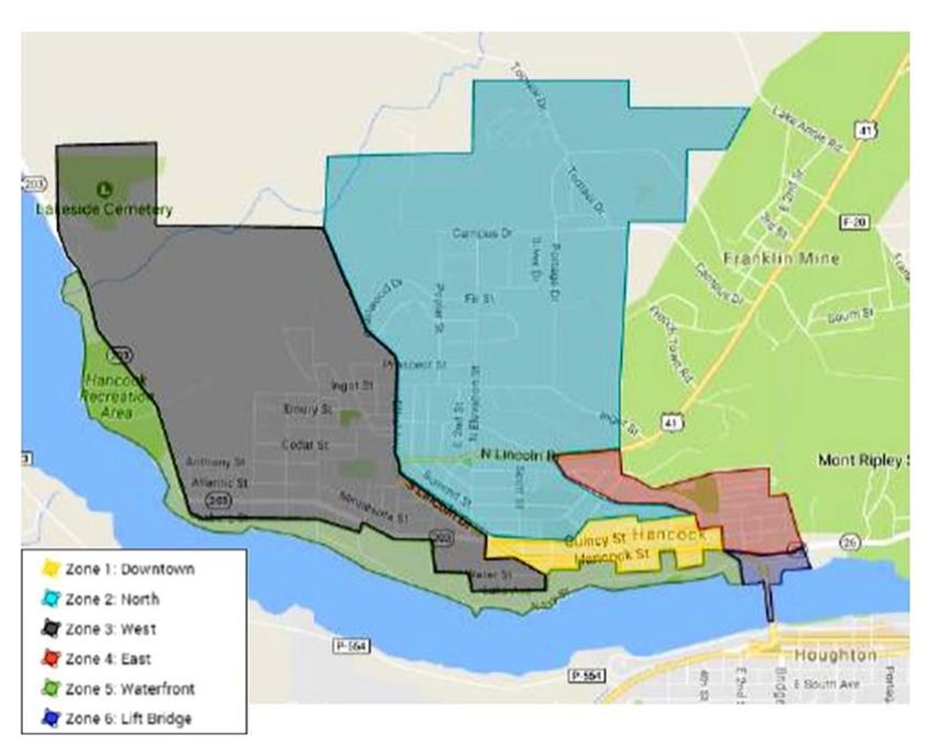
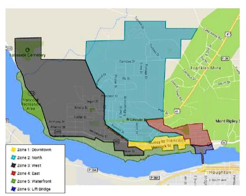
see
zone
boundary
map
on
pg.
21)
and
destination
type
(e.g.,
shops,
restaurant/bar,
recreation,
bank,
post
office).
Top
pedestrian
destinations
by
city
zone
1. Downtown
Hancock
was
the
most
frequented
pedestrian
region
(73
respondents).
The
post
office,
hardware
store
and
the
Orpheum/Studio
Pizza
were
the
most-‐frequented
sites
in
this
region.
2. North
Hancock
was
the
second
most-‐frequented
pedestrian
region
(24
respondents),
where
Pat’s
Foods
and
the
Maasto
Hiihto
trails
were
the
top
destinations.
3. The
third
most-‐frequented
region
by
pedestrians
was
the
Hancock
Waterfront
(17
respondents),
including
the
waterfront
parks,
beach,
multi-‐use
path
and
businesses.
4. West
Hancock
was
indicated
as
a
top-‐three
destination
by
17
respondents,
where
the
Keweenaw
Co-‐op
was
the
most
frequented
site.
5. The
Lift
Bridge/Houghton
was
indicated
by
15
respondents.
6. East
Hancock
was
indicated
by
four
respondents.
Top
pedestrian
destinations
by
type
1. Grocery
stores/gas
stations
were
the
most
frequented
destination
type
among
pedestrians
(37
respondents).
Most
respondents
were
walking
to
the
Keweenaw
Co-‐op
or
Pat’s
Foods.
2. Recreational
walking
and
associated
destinations
were
the
second
most
frequented
type
of
destination
(28
respondents),
with
the
Hancock
waterfront
and
the
Maasto
Hiihto
trails
being
the
most
popular
destinations.
3. Restaurants/bars
and
the
post
office
were
each
indicated
by
15
respondents
as
a
top-‐three
destination
when
walking
in
Hancock.
4. Shops,
including
Risto’s
Hardware
and
St.
Vincent
DePaul,
were
indicated
as
a
top
destination
by
13
respondents.
5. Other
top
pedestrian
destination
types
were
Work/School
(11
respondents),
a
friend’s
home
(9),
Church
(4),
Community
Garden/Farmer’s
Market
(3),
City
Hall
(2)
and
Cultural/Art
Center
(2).
Page
7
City
of
Hancock
Non-‐motorized
Transportation
Network
Plan
|
2017-‐2021
Common
Hancock
cycling
destinations
Hancock
destinations
most
frequented
by
cyclists
(excluding
respondents’
own
residence)
were
the
Lift
Bridge
(31
respondents),
the
Keweenaw
Co-‐op
(10)
and
the
Maasto
Hiihto
trails
(9).
When
these
data
were
summarized
by
city
zone
(see
zone
boundary
map
on
pg.
21)
and
destination
type
(e.g.,
shops,
restaurant/bar,
recreation,
bank,
post
office),
the
following
emerged:
Top
cycling
destinations
by
city
zone
1. The
Lift
Bridge/Houghton
was
the
most
frequented
region
among
cyclists
(31
respondents).
2. West
Hancock
destinations,
including
the
Keweenaw
Co-‐op,
the
Maasto
Hiihto
trails,
Lauren
Grove,
the
County
Fairgrounds
and
access
to
M-‐203,
were
the
second
most-‐frequented
city
region
by
bike
(25
respondents).
3. The
third
most-‐frequented
Hancock
region
was
Downtown,
with
17
respondents.
4. Destinations
beyond
Hancock
to
the
west,
north
or
east
(e.g,
Calumet,
McLain
State
Park,
Lake
Linden)
were
indicated
by
12
respondents.
5. Waterfront
destinations,
including
the
waterfront
parks,
beach,
multi-‐
use
path
and
businesses,
were
indicated
by
11
respondents.
Top
cycling
destinations
by
type
1. Recreational
riding
and
associated
destinations
within
and
beyond
Hancock
were
by
far
(31
respondents)
the
most
indicated
destination
type
among
cyclists.
Top
destinations
within
this
category
were
the
Maasto
Hiihto
trails
and
McLain
State
Park.
2. Grocery
stores/gas
stations
were
the
next
most
frequented
destination
type
(15
respondents).
3. Restaurants/bars
were
the
third
most
frequented
destination
type
among
cyclists
(5
respondents).
Attractions
for
non-‐motorized
travel
in
Hancock
Among
pedestrians,
downtown
and
Quincy
Street
shops
were
either
a
draw
or
a
nice
place
to
walk
for
more
than
half
(37
respondents)
of
those
who
identified
elements
they
Page
8
City
of
Hancock
Non-‐motorized
Transportation
Network
Plan
|
2017-‐2021
liked
about
walking
in
Hancock
in
the
survey
(52).
Various
elements
of
infrastructure
were
also
liked
by
more
than
half
of
respondents
(34),
and
included
the
multi-‐use
path,
steps
and
parks/benches,
the
Maasto
Hiihto
Trails,
wide
sidewalks
downtown,
minimal
side-‐street
traffic,
the
close
proximity
of
destinations,
good
maintenance
and
plowed
sidewalks.
Elements
of
scenic
beauty
were
an
attraction
for
several
pedestrians
(10
respondents),
and
included
views,
the
waterfront,
trees/green
spaces/gardens,
birds,
fresh
air
and
hills!
Opportunities
to
interact
with
neighbors
and
community
members,
courtesy
of
drivers
and
overall
safety
were
also
considered
attractions.
Elements
of
Hancock
infrastructure
that
cyclists
liked
were
summarized
well
by
one
respondent:
"I
like
a
designated
lane
or
trail.
I
use
them
plus
quiet
back
streets."
Specifically,
cyclists
liked:
● Paved
(11
respondents)
and
unpaved
multi-‐use
paths
(e.g.,
to
Calumet;
2).
● Maasto
Hiihto
and
connecting
Churning
Rapids
trails
(7).
● Close
proximity
of
destinations,
increased
accessibility
on
a
bicycle
and
ease
of
travel
(5).
● Light
traffic
on
side
streets
(6),
rideable
sidewalks
(3)
and
wide
roads
(2).
● The
wide
shoulder
on
M-‐203
from
Hancock
to
Hancock
Beach/McLain
State
Park.
Respondents
were
attracted
to
cycling
as
an
alternative
to
driving/a
free
activity
(4),
for
exercise/invigoration/to
get
“ready
for
work”
(3),
as
a
means
to
enjoy
the
waterfront
view
and
hills
(2)
and
for
good
family
fun
(1).
Concerns
for
non-‐motorized
travel
in
Hancock
Pedestrian
concerns
and
areas
for
improvement
Pedestrians
indicated
that
the
following
improvements
would
enhance
their
walking
experience
and
encourage
them
to
walk
more
in/to
Hancock:
1. Safe
road
crossings/Lift
Bridge
access
Nearly
two-‐thirds
of
pedestrian
respondents
(39
of
51)
indicated
that
safe
access
to
destinations
via
“well-‐marked”,
“safe”
and
“signed”crosswalks
and
stairs
as
well
as
the
establishment
of
a
pedestrian
right-‐of-‐way
would
improve
their
experience
walking
within,
to
and
from
Hancock.
The
top
areas
for
improvement
were
crosswalks
across
Hancock
Page
9
City
of
Hancock
Non-‐motorized
Transportation
Network
Plan
|
2017-‐2021
and
Quincy
Streets
(including
the
corner
at
The
Scott
Hotel;
12
respondents),
US-‐41
to
Ethel
Avenue,
US-‐41
to
Pat’s
IGA
and
safe
access
to
the
Lift
Bridge
from
both
Front
and
Navy
Streets/multi-‐use
path.
To
improve
bridge
access,
respondents
suggested
stairs
from
Navy
Street
and
replacing
the
yield
sign
at
the
northeast
end
of
the
bridge
with
a
stop
sign.
One
respondents
commented
that
Hancock
Street
has
become
more
difficult
to
cross
since
White
Street
has
become
a
one-‐way
street,
and
obstructed
view
by
parked
cars
as
a
hazard
to
crossing
Quincy
Street.
2. Winter
access
Consistent
snow
and
ice
removal
during
winter
would
improve
the
walking
experience
for
more
than
half
of
survey
respondents
(28
of
51).
Plowing
was
suggested
on
the
sidewalks
of
Quincy
and
Hancock
Streets
(with
the
south
sidewalk
on
Hancock
Street
receiving
much
mention),
the
paved
multi-‐use
path,
a
route
to
Pat’s
IGA
(including
the
US-‐41
sidewalk),
and
one
downhill
route
to
downtown
and
Navy
Street.
Several
respondents
mentioned
that
large
snowbanks
pushed
into
the
sidewalk
by
businesses
on
Hancock
Street
prevent
safe
winter
walking.
One
respondent
suggested
frequent
removal
of
snowbanks
of
frequented
intersections
to
improve
visibility
of
pedestrians
by
cars
(e.g.,
at
Pat’s
IGA
and
US-‐41)
and
another
suggested
the
establishment
of
a
designated
winter
walking
route
including
frequented
destinations.
3. Number
and
condition
of
sidewalks
and
paths
Increasing
the
number
and
width
and
improving
maintenance
of
sidewalks
and
paths
would
improve
the
walking
experience
for
53
percent
(27
of
51)
of
respondents.
Areas
specifically
mentioned
for
additional
sidewalks/paths
were
near
Barkell
Elementary
School,
on
US-‐
41,
to
Pat’s
IGA/Quincy
Hill
and
steep
hills
such
as
Elevation
Street.
One
respondent
suggested
increasing
the
width
of
the
sidewalk
on
the
bridge
would
more
readily
accommodate
both
cyclists
and
pedestrians.
Improved
sidewalk
safety
and
maintenance
was
requested
by
19
respondents.
Suggested
improvements
included
surface
repairs,
debris
removal,
pruning
of
hedges
growing
into
sidewalks,
fewer
curbs
and
increasing
distance
between
sidewalks
and
roads.
Improvements
to
the
sidewalk
on
White
Street
(3
respondents)
and
steps
replacing
the
current
Page
10
You can also read