City of Ocean Shores RFP Aquatic Plant Management
←
→
Page content transcription
If your browser does not render page correctly, please read the page content below
Northwest Aquatic Ecosystems Inc.

                           City of Ocean Shores
                       RFP Aquatic Plant Management
                                 Northwest Aquatic Eco-Systems
                                855 Trosper Road SW 108 -#313.
                                     Tumwater, WA. 98512
                            360-357-3285(office) - 360-359-2225 (cell)

                           Douglas Dorling (pondweeds@comcast.net)
                                   nwaquaticecosystems.com

Introduction:
Our program format as presented represents the most up to date methods for Eurasian
watermilfoil, Brazilian elodea and native macrophyte control associated with the use of current
registered herbicides related to eradication and control program formats. Our proposal focuses
around two herbicides; in particular, Triclopyr and diquat. These two products have been used
successfully in the past at Ocean Shores and provide an economical solution to fulfill the
recreational needs of the community. Both materials are registered with the EPA and the
Department of Ecology for lake use while also being available world-wide for many years.

It is important to note that Northwest is not an agent for any of the materials identified in this
proposal and has no established agency agreements with any manufacturer. Northwest receives
no monetary agency rebate from any chemical manufacturer based on the quantity of material
incorporated into our control programs. NWAE company is privately owned and not under the
ownership of any chemical manufacturer. Our ability to remain independent, absent of any
agency agreement pressures or financial benefits, allows Northwest to select appropriate
materials and concentration rates as deemed applicable on a site by site basis.

Unlike other consultants based in the Pacific Northwest, NWAE has never defaulted on any
contract.

Our historical treatment timelines have produced acceptable milfoil, B. elodea, submersed native
plants and shoreline emergent species control while embracing both early and late season
applications. Although early seasonal treatment, while plants are experiencing their most
aggressive growth, provides the best environment for success. Late season applications often
produce the same results if the proper materials and concentrations are correctly administered.

We believe our ability to effectively communicate with our clients, state agencies and tribal
entities has allowed us to maintain our strong Washington State client base. Our relationship
with the local tribes and the Department of Ecology has resulted in an open line of
communication that supports a productive environment that seldom results in disappointment.
NWAE has always advocated a welcoming based platform that encourages communication and
participation in an effort to resolve issues or concerns in a friendly stress free environment. These
efforts have resulted in our ability to secure permits in a timely fashion. I am unaware of any

                                  2021 Ocean Shores Aquatic Weed Control                           1
                                       REQUEST FOR PROPOSAL
                                               Page 1 of 11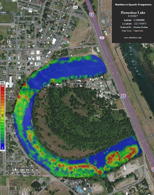
Northwest Aquatic Ecosystems Inc.
permit application that has been denied to NWAE by the Department of Ecology. Our approach
has evolved as the company has matured. Northwest encourages the City of Ocean Shores to talk
with our clients and confirm our status within their organization. We encourage open discussion
between all stakeholders during the development and implementation of any of our management
programs. We meet with all of our Skagit County, Barnes Lake, Hicks Lake, Steilacoom Lake,
Gravelly Lake and other lake clients on a yearly basis.

NWAE has only one violation that involved a new permit requirement implemented during 2015
that obligated us to place on file with the Department of Ecology a list of our business and
residential public notification mailing lists. This was an oversight on our part, probably as a
result of being a new permit requirement never mandated or part of the permit before. Once
notified of the shortfall these lists were supplied to the agency.

One unique aspect of this project is the time necessary to post the shoreline areas prior to
treatment and pre-treatment residential notice. The long narrow canal system provides many lots
that are maintained as camping, vacation as well as a resident population. Notification is
difficult and time consuming. Our past efforts at notifying the public during past campaigns have
proven to be successful.

Previous Experience:
Northwest Aquatic Eco-Systems is the oldest established aquatic weed control consultant within
Washington State, having performed business in the state for over three decades. NWAE
operates as a corporation under a current aquatic pesticide license number 375. Current licensing
certificate numbers being issued by the Department of Agriculture exceed number 92,000.
NWAE specializes in the development and implementation of integrated aquatic pest
management programs incorporating chemical, mechanical and or biological methods to achieve
the desired results. NWAE has developed in excess of 100 treatment plans and has implemented
thousands of control programs throughout the Pacific Northwest. Our expert use of these control
technologies allows us to provide clients with the best approach to solving their native and
noxious aquatic plant problems. This approach has successfully restored valuable lake waters
once infested with exotic and/or nuisance aquatic weeds to fully functional recreational water
bodies.

Our roots and commitment to the region are well documented through our long working
relationships with many of our clients. Most of our client base we have serviced for over thirty
years. Our current active government clients would include but would not be limited to the
following: City of Ocean Shores - Duck Lake and canal system; Skagit County Public Works -
Big Lake, Lake Erie, Lake Campbell, Lake McMurray, Beaver Lake; City of Lacey – Hicks Lake;
City of Tumwater - Barnes Lake; Port of Benton – Colombia River; City of Bellevue - Lake
Washington. All of the above projects represent either Eurasian watermilfoil, B. elodea, or other
submersed non-native noxious and native species.

City of Ocean Shores – Duck Lake and Canals. NWAE has been providing yearly service to this
community since 2007. NWAE performed a total lake fluridone application to the Duck Lake
system during 2007 for the eradication of Brazilian elodea. There have been no B. elodea
                              2021 Ocean Shores Aquatic Weed Control                      2
                                   REQUEST FOR PROPOSAL
                                            Page 2 of 11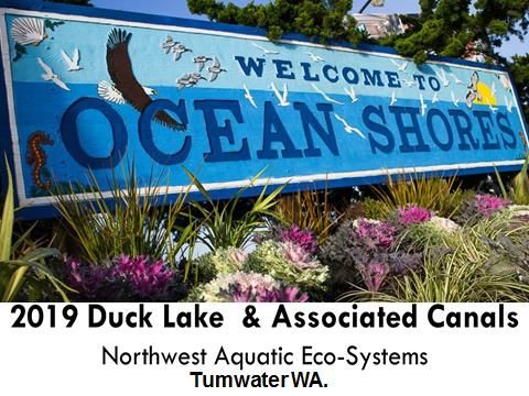
Northwest Aquatic Ecosystems Inc.
sightings since that application. Currently NWAE provides all phases of submersed native,
noxious and emergent weed control.
Nick Bird- 360-940-7500            Bruce Malloy - bmalloy50@gmail.com, 206-818-4118

Skagit County Public Works - Big Lake (520 acres), Lake Erie (114 acres), Clear Lake (220
acres), Lake Campbell (390 acres), Beaver Lake (72 acres). NWAE initiated servicing some of
these lakes in 2010, others in 2012 and we continue to service all on a yearly basis. These are all
LMD funded projects dealing with submerged, floating and emergent noxious weed control.
Three of these projects deal with the native plant water-nymph and all target the fragrant water
lily. Project scopes also include surveys and yearly reports. NWAE can provide copies of any
reports generated from these projects for your review.
Tracy Alker Skagit County Public Works - tracya@co.skagit.wa.us, 360-416-1462

Steilacoom Lake (320 acres) Lakewood WA. NWAE has been involved with this project
every year since 1980 and prior to that as a team project leader for a local company no longer in
business. Services provided include but are not limited to: submersed weed and algae control,
biweekly electronic data field monitoring, monthly water sample collection, toxic algae
monitoring and experimental use of new technology for toxic algae control. Steilacoom Lake is
the largest waterbody (320 acres) in the Pacific Northwest that receives total lake treatments for
the control of toxic blue-green algae.
Ed Brooks – President, ebrooks@bamboomgt.com, 253-279-5000

Our current private client list would include but is not limited to the following: Steilacoom Lake,
Gravelly Lake, Chambers Lake, Fawn Lake, Ken Lake, Lake Susan, Sunwood Lakes, Clyde Loch
Lake, Aqua Vista Lake, Lake Killarney, Custer Lake, Sylvia Lake, Lake Minterwood, Seattle
Yacht Club, Queen City Yacht Club, Parkshore Marina, Harbor Village, Fairview Lake, Spring
Lake and Trails End Lake. NWAE provides service to nearly 50 waterbodies per year and if
requested, can provide an impressive, expanded list of other non-local state-wide waterbodies
that we have serviced for over 25 years.

Northwest Aquatic Ecosystems is very familiar with all of the targeted sites identified in the City
of Ocean Shores RFP. We have provided control services for this project site for over 25 years.
Our team has successfully completed all of the tasks identified in this RFP for the City of Ocean
Shores on numerous occasions.

NWAE application team will consist of trained licensed applicators, technicians and shoreline
support. Our team will be represented but not limited to the following personnel.

Doug Dorling owner (license #375) Mr. Dorling has been involved with developing and
implementing lake management plans for nearly 40 years on both the East and West coast. Mr.
Dorling will oversee the entire project and supervise all spraying, surveying, report generation,
electronic and verbal communication and plan development. Mr. Dorling is familiar with the
site, local community and has presented slide presentations addressing past yearly treatments to
the Ocean Shores Waterways Committee and to the Ocean Shores council members.

                                  2021 Ocean Shores Aquatic Weed Control                         3
                                       REQUEST FOR PROPOSAL
                                               Page 3 of 11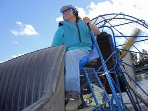
Northwest Aquatic Ecosystems Inc.
Barb Chitty – Aquatic technician, boat operator. Daily maintenance of equipment and would
supervise shoreline posting and pretreatment residential notice distribution.
Chris Martin – Airboat operator and general mechanic. Supervises staging area and the loading
of material onto the treatment boats.
Jennifer Dorling- While waiting to start her medical residency program Jennifer, directs on a
part time basis all Facebook and Web site communications. She is also a skilled airboat
operator.

Like most lake management firms that deal with herbicide applications, secondary help is
provided through the local work force that typically consists of college students working during
the summer months on a yearly basis. We currently provide employment to a 5th year medical
student waiting to take her residency exam. Our summer help typically consists of employees
that have worked for NWAE during prior summers. Mr. Dorling, the owner will be present
during all job site visits.

Task #1 Aquatic Vegetation Surveys
NWAE has conducted electronic sonar vegetation surveys of all the targeted canals since 2014.
Past surveys also produced bathymetric and sediment composition maps. Our knowledge and
familiarity with the entire system cannot be equaled by any other consultant in the region. Our
mapping protocol consists of the following components and is an industry standard.

The pretreatment macrophyte survey will determine the density and composition of the aquatic
species throughout the sites. The survey will assist in determining what areas will be targeted for
control in accordance with budgetary restraints. If the proposed sites are dominated by
problematic native species, then targeting just the milfoil may not produce the seasonal relief one
may anticipate.

NWAE has been utilizing this technology for many years and has produced hundreds of
vegetation maps that are GIS friendly. The pretreatment survey will accurately produce an
updated bathymetric map of the canal bottom that will be used to calculate treatment volumes
and acreages associated with specific targeted canal areas defined by extrapolated polygon
shapes. Our mapping program has the ability to evaluate different survey events and can produce
data directed at plant biomass changes on a map-to-map basis. This is an extremely important
component of the program because it allows for easy pre and post treatment analysis. Another
favorable component of this program is the ability to clearly define whether a treatment
has successfully controlled the targeted species at a level acceptable to the client utilizing
both visual and analytical tools to quantify treatment results.

Our mapping program allows for the evaluation of all data collected in a variety of formats
allowing for informed interpretation of survey results. Evaluation formats provide for the
following data reviews (BioBase program text).

AOI
       Area of Interest: Defines the individual transects or contiguous data samples as depicted by the color coding of each trip line.
       Seperate areas of interest can be generated through merging of multiple trips, appending data to a single sonar log or lapses in
       time (greater than five minutes) within a sonar log.
                                            2021 Ocean Shores Aquatic Weed Control                                                    4
                                                 REQUEST FOR PROPOSAL
                                                         Page 4 of 11
Northwest Aquatic Ecosystems Inc.
BVp
Biovolume (Plant): Refers to the percentage of the water column taken up by vegetation when vegetation exists. Areas that do
not have any vegetation are not taken into consideration for this calculation.
BVw
Biovolume (All water): Refers to the average percentage of the water column taken up by vegetation regardless of whether
vegetation exists. In areas where no vegetation exists, a zero value is entered into the calculation, thus reducing the overall
biovolume of the entire area covered by the survey.
PAC
Percent Area Covered: Refers to the overall surface area that has vegetation growing.
NWAE also incorporates drone technology into our surveying efforts. This component of our
survey protocol will not be included in this project but can be added if requested. NWAE utilizes
a DJI Phantom 3 Professional drone that captures 4K video at up to 30 frames per second and 12
megapixel photos. Pretreatment pictures/videos are evaluated against post treatment aerials
taken at the end of the season. This approach again allows for simple but precise evaluation of
spraying efficacy.
Please follow the link https://www.youtube.com/watch?v=CXeYNPivpKA to experience an
aerial tour of Barnes Lake utilizing Phantom 3 technology.
1.1 Pre –Treatment Survey (Mapping, GIS):
Ocean Shores staff and the Waterways Advisory Board will be notified no less than five days
prior to the survey. The survey vessel will accommodate one representative from the City or
Advisory Board and will be conducted during late April through early June. Results will be
discussed with the City and/or Advisory Board members.
Our mapping protocol utilizes state of the art Bio Base mapping technology. This system
produces three map types during one survey event consisting of a bathymetric contour, a
sediment composition profile and a macrophyte density map. All maps are GIS friendly with the
data having the ability to be exported into any GIS program. Maps are color coded so they can be
easily evaluated by any viewer.
Mapping technology utilizes specialized transducers that electronically collect thousands of data
points as the survey boat transects proposed the treatment site. Data is recorded and viewed
onboard. Data is then downloaded and processed. The survey and sonar log produces a stored
electronic file of the lake bottom that can be viewed in house at any time and allows the ability to
view all plant growth along the boats survey track. This Bio Base mapping technology avoids the
possibility of missing plants between manually collected single bottom surveying data points.
Our protocol encompasses a surface vehicle transecting the lake along the entire lakes littoral
zone. Boat tracks are designed to be approximately 75 feet apart with the sonar beam collecting
data 150 feet from all directions surrounding the boat. To ensure the efficacy of the survey, a
bottom sampling rake is thrown from the boat at various locations lake-wide. The rake is then
drawn across the lake bottom, brought to the surface and into the boat. Plants attached to the
rake are identified and confirmed as being the same species as noted through the scan or visually
noted through the water column. The sampling point is then incorporated into the file data log as
a single point reference noting all the species captured during the rake tow. These points are then
added to the final project map.
2021 Ocean Shores Aquatic Weed Control 5
REQUEST FOR PROPOSAL
Page 5 of 11Northwest Aquatic Ecosystems Inc.
Ocean Shores staff and Waterways Advisory Board will be notified no less than five days prior to
the survey. The survey vessel will accommodate one representative from the City or Advisory
Board and will be conducted during late April through early June.
Material use and site specific treatment protocol will be determined after the pretreatment survey
is processed and evaluated. Once the survey is completed, recommendations will be made to the
City of Ocean Shores suggesting material usage and treatment scenario on a site by site basis.
The City of Ocean Shores and all stakeholders will then have the opportunity to comment on the
proposed sites and make any appropriate changes.
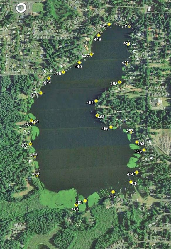
GPS Grab Sample GPS Coordinates
Data
Point Lat Long Species
443 N47 01.438’ W122 48.074’ NG, N
444 N47 01.494’ W122 48.032’ NG
445 N47 01.518’ W122 47.952’ NG
446 N47 01.155’ W122 47.865’ NG
447 N47 01.587’ W122 47.798’ NG, N, PA
448 N47 01.662’ W122 47.757’ NG
449 N47 01.705’ W122 47.699’ NG
450 N47 01.698’ W122 47.586’ NG, PA
451 N47 01.627’ W122 47.593’ NG
452 N47 01.550’ W122 47.602’ NG
453 N47 01.478’ W122 47.641’ NG, PA
454 N47 01.407 W122 47.769’ NG
455 N47 01.352 W122 47.763’ NG
456 N47 01.308 W122 47.689’ NG
457 N47 01.290 W122 47.581’ NG, BL
458 N47 01.253’ W122 47.548’ NG
459 N47 01.224’ W122 47.510’ NG, BL
460 N47 01.141’ W122 47.551’ NG, BL
461 N47 01.107’ W122 47.583’ C, BL
462 N47 01.071’ W122 47.678’ NG, BL, C
463 N47 01.040’ W122 47.827’ NG, PA
464 N47 01.025 W122 47.873’ NG, BL
465 N47 01.132’ W122 48.085’ NG
466 N47 01.202’ W122 48.098’ NG
467 N47 01.245’ W122 48.124’ NG, PA
468 N47 01.325 W122 48.107’ NG
469 N47 01.334’ W122 48.122’ PC, PA
Grab Sample Point Dictionary
NG- Najas guadalupensis (water-nymph)
PA- Potamogeton amplifolius (broad leaf pondweed)
B - Utricularia – (bladderwort)
C - Ceratophyllum – (coontail)
N - Nitella - (algae)
2021 Ocean Shores Aquatic Weed Control 6
REQUEST FOR PROPOSAL
Page 6 of 11Northwest Aquatic Ecosystems Inc.
1.2 Post –Treatment Surveys
A brief visual and rake tow survey will be conducted 30 days following the initial application.
This survey will determine if additional treatment will be required. Results will be
communicated to the city and discussions will transpire addressing the need for any additional
treatments. If a secondary treatment is required, it will be performed approximately 14 days after
receiving a confirmation from the city to proceed.
Our final survey of the season will be an electronic event scheduled during September. All
protocols and communications asserted during the pre-treatment survey will again be instituted
during this post treatment survey event.
Task 2: Aqautic Plant Management:
2.1 Aqautic Plant and Management General Permit:
NWAE has secured the NPDES permit required to complete this task. Most recently we were
able to secure an extension of the permit for an additional five years. All treatment records and a
copy of the permit will be included in the final report.
2.2 Public Notification:
All public notification requirements as specified within the NPDES permit for this project will be
adhered to. These requirements are similar to those utilized in the past and are ones that NWAE
has been able to fulfill during all prior treatments at Ocean Shores. An appearance notice will be
given to the City and Advisory Board no less than 5 days prior to any NWAE presence on the
waterways. In addition to those requirements identified in the NPDES permit, notice and
2021 Ocean Shores Aquatic Weed Control 7
REQUEST FOR PROPOSAL
Page 7 of 11Northwest Aquatic Ecosystems Inc.
information about the treatment will be posted in the Daily World newspaper. Boat launches will
be posted with signs no less than 24 hours prior to treatment requesting reduced boating activity
on the day of treatment and for 24 hours post treatment. An affidavit of publication will be
included in the final report. These additional public boat launch postings and newspaper notice
are identical to the programs NWAE on implemented on numerous Skagit County projects a few
years past. NWAE will mail or hand deliver to each shoreline property owner the pretreatment
notice as required within the NPDES. This is a form notice produced by the Department of
Ecology that requires site specific related information. A partial mailing list has already been
developed as a result of past treatments.
NWAE supports a Facebook and Web page that publishes treatment notices, lake appearances
and other project information. We also develop and support email lists on a site by site basis.
Notices about the City of Ocean Shores treatment activities can be available to local residents
subscribing to our Facebook page, email list or web site. NWAE retains one person specifically
to perform those tasks. Our Facebook and Web pages have produced many comments directed at
past Ocean Shores’ treatment projects.
No more than 24 hours pre application shoreline posting will occur that will utilize the
Department of Ecology templates for the materials selected for use. Notices will be placed along
the shoreline in accordance with the NPDES mandate. In addition to the required small shoreline
postings, all public boat launches swimming beaches and private swim community beaches will
be posted with large 2 foot by 4 foot signs in accordance with the NPDES mandate. The City of
Ocean Shores, if warranted, may close any of the public use sites during treatment.
Pre-treatment notifications also include newspaper ads and possible radio announcements.
2.3 Herbicide Treatment:
Our control protocol will address treatments associated with Triclopyr and diquat. If our pre-
treatment survey identifies that other materials may be required, then additional information will
be provided to the city. Diquat is only available as a liquid formulation and would be applied at
a rate of one to two gallons per surface acre. It is also the only material registered in Washington
State except for fluridone that will control elodea; one of the dominant species throughout the
waterways. Diquat will also control pennywort, duckweed and red fern, all floating species that
prevail throughout the waterways. When utilizing diquat for submersed weed control you also
provide control of these floating species when present at the time of treatment. Diquat is applied
using weighted drop hoses and injecting the material down into the water column.
Diquat and triclopyr, when utilized for submersed weed control, are typically injected mid water
column. Treatments will be performed utilizing a flat bottom Airgator airboat or pontoon boat.
Both types of application boats are standard throughout the industry providing the operator the
ability to maneuver, operate in shallow waters and traverse the treatment site effortlessly without
interrupting the application. Holding tanks on board are filled with the selected herbicide. Clean
lake water is drawn from the lake and then passes through an injection manifold where the
2021 Ocean Shores Aquatic Weed Control 8
REQUEST FOR PROPOSAL
Page 8 of 11Northwest Aquatic Ecosystems Inc.
subsequent tank mixture is metered into the manifold. The resulting herbicide and lake water
mixture is then infused back down into the water column at the desired depth.
When applying material such as triclopyr for floating plant (pennywort or parrot feather) control
a ¾% solution is tank mixed with clean lake water and surfactant. Once mixed the herbicide
mixture is sprayed over the targeted species utilizing a spray gun with an adjustable nozzle. As
the boat passes along the shoreline, targeted sites are identified and sprayed. Triclopyr is
selective towards pennywort, lily pads and parrot feather. Utilizing this product will have no
impact on shoreline cattails or water iris. These species are critical in stabilizing the waterways
shoreline. If cattails or water iris are targeted than imazapyr would be incorporated into the
project toolbox.
NWAE encourage the City of Ocean Shores to monitor product use throughout the application
process. Boat tracks are recorded using a Lowrance HDS7 Generation 3 recorder so that
documentation is available to verify that the boat accessed every targeted site.
Staging Area – NWAE has identified a number of private residential properties throughout the
waterways that we have utilized previously as staging areas during prior treatment phases.
These sites provide easy access and the transferring of material from locked vehicles to the
treatment boats. More importantly, the use of private property for staging treatments eliminates
the possibility of protesters interfering with the operation as may occur at public launch sites.
2.4 Aquatic Plant Control Maps
NWAE has been providing GIS friendly mapping depicting survey results to our clients for many
years. We would request the city to review our attached year-end report format that provides all
of the information requested in this RFP.
Task 3: Project Reports:
Please review the attached final report. This report provides all of the information requested
within the RFP. If any data or information currently being identified in the RFP has been omitted
in this report such will be included in the Ocean Shores year-end review.
2021 Ocean Shores Aquatic Weed Control 9
REQUEST FOR PROPOSAL
Page 9 of 11Northwest Aquatic Ecosystems Inc.
Task 4: Communications
Northwest has historically provided exceptional communication between lake clients and our
staff. As mentioned earlier, NWAE supports a web and Facebook page that in the past has been
used to inform residents of our daily lake activities. We will continue the use of these tools
throughout the duration of the project. Invoices will contain a brief description of what each
billed item is composed of.
In the past NWAE has presented Power Point presentations to the city council and waterways
committee. Past presentations can be reviewed at the Fresh Waterways Committee web page.
NWAE will continue this practice of providing information and appearances to the city or
waterways committee whenever requested.
Proposed Timeline: (from a designated targeted treatment date)
Day # Action Taken
April/May Pretreatment Survey
7 Survey results submitted to city for review
14 Final treatment plan and budget established.
21 Pre-treatment residential notification.
Early June Pre-treatment lake shoreline posting
Early June Lake treatment
July Brief lake inspection
Early August Secondary application if necessary
September Post Treatment survey
Dec 1 Final Report
2021 Ocean Shores Aquatic Weed Control 10
REQUEST FOR PROPOSAL
Page 10 of 11Northwest Aquatic Ecosystems Inc.
Budget: (NWAE is a sales tax exempt corporation. No sales tax will be added
to total project cost)
Floating Expenses Fixed Costs
Pre-Treatment Aquatic Survey (two day event) $ 2,000.00
Pre-Treatment Residential Notice $ 2,000.00
Pre-Treatment Shoreline Posting $ 2,000.00
Diquat Submersed Weed Control @ $290.00/acre
Shoreline Pennywort Control (One day event) $ 1,800.00
Shoreline Parrot Feather Control $ 1,200.00
Post Treatment Site Visit (Survey) 250.00
Post Treatment Electronic Bottom Survey $ 1,800.00
Final Report $ 500.00
Insurance $ 750.00
2022 Expenses:
NWAE believes that there should not be any major changes to the financial structure of the
2022 treatment program. Treatment recommendations and pricing for the 2022 season will be
included in the final report. As a budgetary line item however a 5% increase should be
anticipated to reflect the possible increase in permit fees, insurance, labor and chemical expenses.
Sales tax exemption though associated with the 2021 should cover those costs.
2021 Ocean Shores Aquatic Weed Control 11
REQUEST FOR PROPOSAL
Page 11 of 11You can also read