CITY OF PORT ST. LUCIE MOBILITY PLAN & FEE RECOMMENDATIONS
←
→
Page content transcription
If your browser does not render page correctly, please read the page content below
2021 Port St. Lucie Mobility Plan & Fee

           CITY OF PORT ST. LUCIE MOBILITY PLAN & FEE RECOMMENDATIONS

To develop a mobility plan and mobility fee with an effective date of October 1st, 2021, there are
several policy decisions that require confirmation from the City. These recommendations have
been prepared in consultation with Port St. Lucie Staff and van Vonno Consulting. The intent of
the mobility plan and mobility fee is to allow the City to replace transportation concurrency,
proportionate share, the City’s existing road impact fee and St. Lucie County’s road impact fee.
The mobility fee will provide the City with a revenue source from new development to fund
multimodal projects on City, County, and State right-of-way within and surrounding the City.

The mobility plan and fee scope has been provided in two parts given the need to meet the
October 1st, 2021 implementation date. Several options have been discussed with Staff related
to the identification of improvements for inclusion in the mobility plan and the establishment of
service standards. The recommended approach for identification of improvements to be included
in the mobility plan is to designate needed road and intersection improvements as either
Mobility or Multimodal. The detail for each type of improvement will be further refined through
community outreach and workshops in phase two of the mobility scope. This high-level hybrid
approach has been successfully implemented in Sarasota and Osceola Counties.

The designation of a Mobility improvement would indicate the roadway or intersection needs
additional capacity for vehicles (e.g. cars, trucks, SUVs), in addition to complete street elements
such as sidewalks, bike lanes and transit stops. The designation of a Multimodal improvement
would indicate the roadway or intersection needs additional multimodal capacity for moving
people (e.g. bicycling, walking, scooting, shared mobility, transit), but does not include adding
capacity for vehicles. The mobility plan is proposed to include the following four types of
improvements (Attachment A):

•    Mobility Corridors: Include the addition of road capacity provided by new roads, the
     widening of existing roads, and the upgrade and change in functional classification of existing
     roads. All road capacity projects would include complete street elements;

•    Multimodal Corridors: Include the addition of person capacity provided by new, retrofitted,
     or widened bike lanes (e.g., buffered, green markings, protected, standard), shared-use
     sidewalks, paths and trails, dedicated lanes for micromobility devices (e.g. electric bikes {e-
     bikes}, electric scooters {e-scooters}), microtransit vehicles (e.g. autonomous transit shuttles
     {ATS}, golf carts, neighborhood electric vehicles {NEV}, trolleys), and high occupancy
     dedicated lanes for transit and shared mobility services (e.g. carpool, vanpool, car-share, ride-
     share {Uber or Lyft}). Multimodal corridors do not include vehicle capacity improvements;
                                                                                                         1
Version 1.0 - 04/14/2021: version 1.5
2021 Port St. Lucie Mobility Plan & Fee
• Mobility Intersections: Include the addition of road capacity provided by new or expanded
turn or thru lanes at intersections, the addition of traffic signals or roundabouts, along with
new interchanges at Interstate 95 and the Turnpike; and
• Multimodal Intersections: Include the enhancement of intersections provided by adding high
visibility crosswalks, protected intersections, raised median islands (to limit crossing
distance), and mid-block crossings with an advance warning signals such as rectangular rapid
flashing beacons (RRFB) or high-intensity activated crossWalK signals (HAWKS).
Level of Service (LOS) & Quality of Service (QOS) standards
The replacement of transportation concurrency with a mobility plan and mobility fee is an
opportunity to revise the City’s current practice of evaluating road capacity on a segment-by-
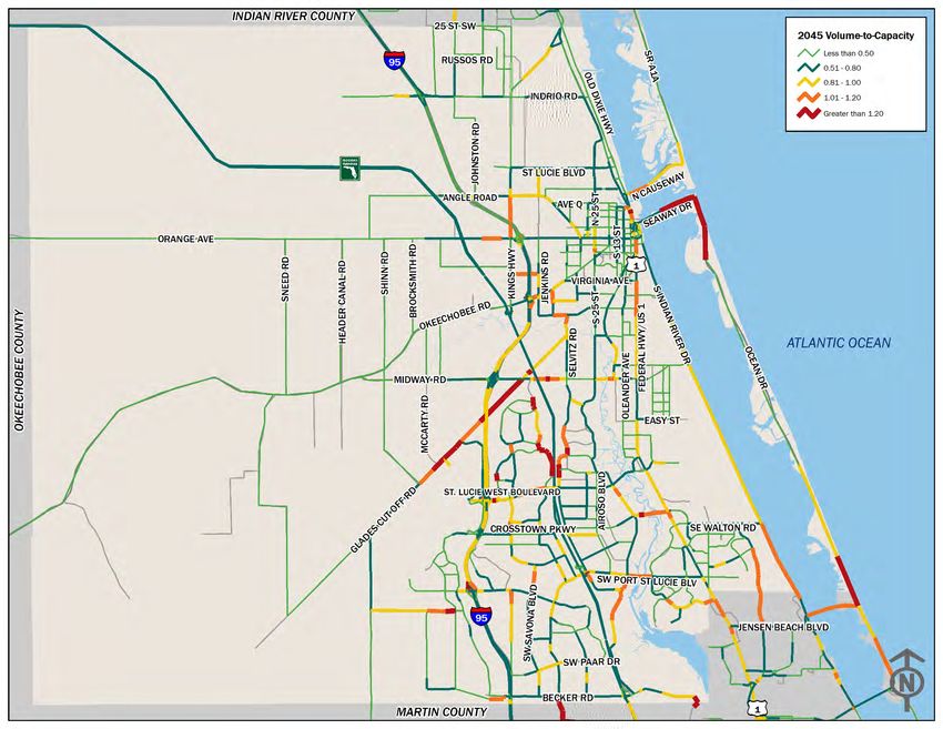
segment basis using a metric known as a volume-to-capacity (V/C) ratio. The V/C ratio measures
PM Peak Hour (between 4 PM and 6 PM) or Daily Traffic divided by the capacity of a given road
based on an adopted LOS standard. For example, a four-lane road with 30,000 cars a day and a
capacity of 40,000 cars would have a V/C of .75%. A two-lane road with 20,000 cars a day and a
capacity of 18,500 would have a V/C of 1.08%, meaning the two-lane road is over capacity. The
2045 Long Range Transportation Plan (LRTP) for St. Lucie County uses this approach to evaluate
the need for future roadway improvements (Attachment B).
Florida Statute 163.3180 allows local governments to establish areawide road LOS standards and
multimodal quality of service (QOS) standards as part of a mobility plan. The intent of an
areawide road LOS is to evaluate the capacity and traffic of a gridded transportation system
versus a segment-by-segment approach. An areawide LOS analysis is conducted in recognition of
the potential for an interconnected network to disperse traffic across multiple corridors. Using
the two road examples from above, the combined traffic for the two roads is 50,000 cars a day,
with a combined capacity of 58,500, resulting in a V/C ratio of .86%, meaning the two roads
evaluated together indicate the area has capacity, but is close to being over capacity. This analysis
is conducted over a larger area and includes multiple roads, but the example illustrates the
difference between a segment-by-segment LOS and an areawide LOS.
The road improvements identified on the draft mobility plan maps (Attachment A) are initially
based on the V/C analysis performed for the 2045 LRTP (Attachment B). Should the Council elect
to move forward with an areawide approach as permitted by Florida Statute 163.3180, the
mobility plan could feature fewer Mobility Corridor improvements than what is currently shown
on the mobility plan maps. An areawide LOS provides flexibility in future mobility planning by
recognizing the available capacity of a network to move traffic versus an individual roadway.
2
Version 1.0 - 04/14/2021: version 1.5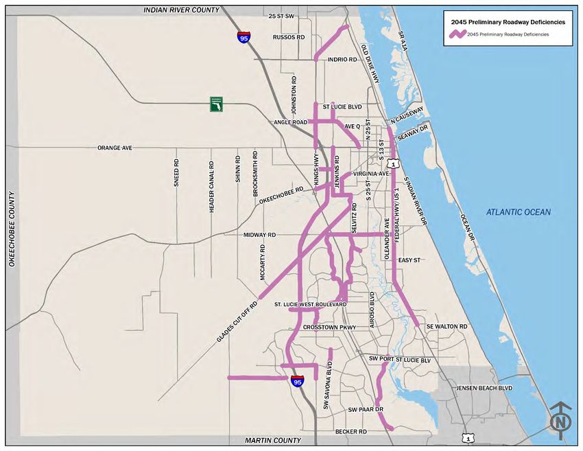
2021 Port St. Lucie Mobility Plan & Fee

Florida Statute 163.3180 also allows local governments to establish multimodal and street QOS
standards for people bicycling, walking, accessing transit, and making roads safer for all users.
Areawide LOS, multimodal and street QOS standards are intended to be used for the following
planning and design activities:

(1)     Phase 2 development of the Mobility Plan;
(2)     Future performance measures;
(3)     Future updates of the City’s mobility plan;
(4)     Evaluation of comprehensive plan amendments;
(5)     The design of complete streets, and
(6)     Determining multimodal capacities for the mobility plan and fee.

It is recommended that the following five (5) locations be established to evaluate capacity on an
areawide basis based on an areawide LOS standard of “D” in order to refine the need for roadway
capacity to be included as part of the mobility plan (Attachment C):

(1) All areas of the City east of the St. Lucie River;
(2) Areas south of Midway, west of St. Lucie River, north of St. Lucie Blvd, east of 95;
(3) Areas south of St. Lucie Blvd, west of St. Lucie River, north of Martin County, east of 95;
(4) Areas south of Midway, west of 95, north of Glades Cut-Off, east of City Limits; and
(5) Areas south of City Limits, west of 95, north of Martin County, east of Range Road.

Quality of Service (QOS) standards
Florida Statute 163.3180 also allows for establishing quality of service (QOS) standards for
multiple modes of transportation. Since transportation concurrency is intended to be replaced
by a mobility fee, the establishment of a street QOS, based on posted speed limits, provides an
opportunity to prioritize safe travel of all modes of travel versus the level of capacity provided by
roads. Establishing street QOS standards allow for an eventual transition beyond areawide LOS.
Street QOS standards are intended to be phased in over time and may be initially applied certain
geographic areas such as east of the St. Lucie River or in selected neighborhoods.

Under a street QOS, the lower the posted speed, the better the QOS. Street QOS standards are
focus on the safe movement of people biking, walking and accessing transit versus LOS standards
based on the capacity to move cars. The establishment of Street QOS standards allows for greater
flexibility in the design and redesign of existing roads and streets.
                                                                                                       3
Version 1.0 - 04/14/2021: version 1.5
2021 Port St. Lucie Mobility Plan & Fee
Street QOS standards allow the City to establish a Street QOS of “A” for a given street or area to
make it safer for all people to use the street; rather than stating we accept a LOS of “D”, “E” or
“F” and the associated congestion that results from being unable to widen roads where the
community does not necessarily want them to be widened. The following Street QOS standards,
based on posted speed limits, encourages slower vehicle speeds and creates a safer environment
for people to walk, bicycle and access transit. To truly effectuate change, under a QOS the design
speeds for roads would be the same as posted speed limits.
Posted Speed Limit Street Applicable Location
QOS Standard
20 MPH or less A Local, Residential & Shared Streets, Select Streets
Local & Residential Streets, Minor Collectors, Select
25 MPH B
Collectors and Arterials
Select Local Streets, Minor and Major Collectors,
30 MPH C
Select Arterials
35 MPH D Major Collectors, Minor Arterials & Select Streets
40 MPH or greater E Select Streets & Principal Arterials
Florida Statute 163.3180 (5)(f)(5) identifies the establishment of multimodal service standards as
part of an alternative to transportation concurrency. The multimodal QOS standards are used to
establish multimodal capacities for the mobility fee calculations. The intent of multimodal QOS
is to provide a framework for expansion of the multimodal transportation system over time.
While the current QOS provided by the transportation network in the City may be less than
desired, the current conditions will serve as a baseline to evaluate improvements over the 25-
year time frame of the mobility plan (aka performance measures).
The higher the multimodal QOS for a sidewalk or bike lane, the higher the likelihood that people
will actually bicycle or walk, thus utilizing more of the person capacity provided by a sidewalk or
bike lane. Multimodal quality of service for people walking and bicycling are influenced by three
factors: (1) the type of facility provided (e.g., sidewalk, bike lane); (2) the distance of separation
between the facility and cars (e.g., buffers); and (3) the presence of a physical barrier between
the facility and cars (e.g., street trees, on-street parking). Phase 2 of the scope with further refine
the elements of complete streets and the proposed multimodal QOS standards.
4
Version 1.0 - 04/14/2021: version 1.52021 Port St. Lucie Mobility Plan & Fee
The following are the QOS standards for sidewalks, paths and trails that accommodate non-
motorized travel demand for people walking, jogging, running, skating, or riding a bicycle. These
standards would often be referred to as pedestrian QOS. However, the label of pedestrian,
besides being a technical term, leaves out people bicycling. Studies have found describing the
activity the people are doing, versus pedestrian or cyclists, has a more positive connotation and
is easier for the general public to relate when describing someone riding a bike, walking on a
sidewalk, or riding a golf cart. A five (5) foot sidewalk adjacent to travel lanes would result in a
QOS !E” and a twelve (12) foot wide trail separated from travel lanes by a landscaped buffer
would be a QOS !A”. Below is a table illustrating the QOS standards for people bicycling and
walking on sidewalks, paths and trails:
Multimodal Quality of Service Standards for Bicycling and Walking
Type of Separation from Travel Lanes
Facility Type Limited Street On-Street Landscape Speed Limit
Separation Trees Parking Buffer 30 MPH or <
Trail 12’ or wider B A A A A
Path 10’ C B B B B
Path 8’ D C C C C
Sidewalk 7’ or less E D D D D
Source: QOS Standards established by NUE Urban Concepts, LLC
Notes: The presence of two or more physical separation features, such as on-street parking and street trees would result in
an increase in one additional letter grade. For example, a ten (10) foot wide path with street trees and on-street parking would
achieve a quality of service of “A”, a five (5) foot wide sidewalk with street trees and a landscape buffer would achieve a
quality of service of “C”
The following are the QOS standards for bicycle boulevards, bike lanes and paved shoulders that
accommodate travel demand for people skating, riding a bicycle, scooter, skateboard, or riding a
micromobility device. A four (4) foot bike lanes adjacent to travel lanes would result in a QOS
“D”, while a five (5) foot bike lane with a three-foot buffer would result in a QOS of “B”. Phase 2
of the scope will further define the types of physical separation, pavement markings and signage.
The allowance of micromobility devices (e-bikes and e-scooters) will be further discussed in the
second phase of the mobility plan, as well as multimodal lanes. In addition, Florida Statute also
allows local governments to designate facilities to also accommodate microtransit vehicles (e.g.,
golf carts and low speed vehicles) as well as bicycles and micromobility devices. Given the wide
rights-of-way available on some roads within the City, there are multiple opportunities to add
innovative multimodal lanes beyond standard bike lanes and paved shoulders.
5
Version 1.0 - 04/14/2021: version 1.52021 Port St. Lucie Mobility Plan & Fee
Multimodal Quality of Service Standards for Bicycling and Micromobility
Type of Separation from Travel Lanes Enhanced Maximum
Facility Type Limited Visibility Posted Speed
Protected Buffered Markings Limit
Separation
Multimodal lane for motorized and non-motorized and transportation (15-20 MPH)
Multimodal lane 7’ B A A A 30 mph – A
Multimodal lane 6’ C A B B 25 mph – B
Multimodal lane 5’ D B C C 20 mph – C
Bicycle Lane primarily for non-motorized transportation
Bike lane 6’ or more C A A B 30 mph – A
Bike lane 5’ D A B C 25 mph – B
Bike lane 4’ E B C D 20 mph – C
Paved Shoulder E B C D 20 mph – D
Bicycle Blvd -- -- -- -- 15 mph – B
Source: QOS Standards established by NUE Urban Concepts, LLC
Notes: The presence of a physical separation features, along with pavement markings and posted speed limits would result in an
increase in one additional letter grade. Protected bike lanes feature a physical barrier such as a raised median between vehicle
and bicycle lanes. Buffered bike lanes feature a buffer at least two (2) feet in width with either chevrons, RPMs, or flex post
between vehicle and bicycle lanes. Enhanced visibility includes pavement markings such as, green or blue lanes, green or blue lane
markings approaching and crossing intersections and driveways, or double lines, spaced a minimum of four (4) inches apart and
featuring RPMs or flex post between vehicle and bicycle lanes.
The following QOS standards for transit are based upon the frequency of service during peak
periods and the type of transit service provided. The QOS standards are only for corridors that
feature transit service and are intended initially to identify the quality of service provided. It
should be recognized that the City has little say in the headways provided by rail and bus
operators. The City does have greater ability to pursue higher QOS standards for trolley and
microtransit providers and may ultimately elect to utilize the QOS standards for public/private
partnership proposals and during the annual capital improvements planning process. The 2nd
phase of the scope will address the addition of dedicated multimodal ways for micromobility
devices and microtransit vehicles and dedicated transit lanes or high-occupancy vehicle (HOV)
lanes for microtransit, trolleys, transit and shared mobility providers (e.g., Uber, Lyft). Based on
the wide rights-of-way available on some roads within the City, there are multiple opportunities
to add innovative multimodal ways, dedicated transit lanes, and HOV lanes.
6
Version 1.0 - 04/14/2021: version 1.52021 Port St. Lucie Mobility Plan & Fee
Multimodal Quality of Service Standards for Transit
Regional Transit Providers Representative of City Transit
Frequency of Service Rail Bus Microtransit Trolley
10 minutes or less A A A A
15 minutes A A B A
20 minutes A B C B
30 minutes B C D C
45 minutes C D E D
60 minutes D E E E
Source: QOS Standards established by NUE Urban Concepts, LLC
Notes: A span of service exceeding 14 hours would result in an increase in one additional letter grade. A function of being
able to achieve QOS A and B frequency is the provision of multimodal ways, dedicated transit lanes, and HOV lanes.
Mobility Fee Assessment Areas
The mobility fee program allows for the establishment of different assessment areas that
recognize that certain geographic locations or types of developments will result in shorter trips,
more people walking and bicycling, and higher levels of internal capture; thus, minimizing impact
to the external roadway network. A local government would typically establish multiple
assessment areas if there were a desire to see mobility fees vary as a means to encourage
development within a defined location or a specific type of development pattern. Multiple
assessment area options within the City of Port St. Lucie were considered based on a review of
the Future Land Use Element and Map, Community Redevelopment Area (CRA) Master Plans,
and current development patterns. The City is under no obligation to establish varying
assessment areas and the City could elect to choose a single assessment are for the entire City,
similar to the current road impact fee.
It is recommended, after plan review and discussions with Staff, that the following two
assessment areas be established (Attachment D):
(1) All areas of the City east of the St. Lucie River; and
(2) All areas of the City west of the St. Lucie River.
The net result is mobility fees will be lower east of the St. Lucie River. The lower mobility fee rate
east of the St. Lucie River reflects a more compact land use pattern, a more extensive street
network, a greater mixture of land uses and less overall need for new road capacity.
7
Version 1.0 - 04/14/2021: version 1.52021 Port St. Lucie Mobility Plan & Fee
Mobility Fee Benefit District
The “benefit” test of the dual rational nexus test requires the development that pays a fee
receives a benefit from that payment. Legislation specifically requires that local governments
keep fees in separate specific purpose funds and that local governments are able to demonstrate
annually that fees collected and expended are consistent with the implementing fee ordinance
and not transferred to general revenue accounts. The City currently has a unified benefit district,
and it is recommended that the City maintain a unified benefit district (Attachment E). It should
also be noted, that in areas where the City has entered into agreements with developers to front
end multimodal improvements and has agreed to reimburse the developer from impact fees or
mobility fees paid by new development within a defined area, that those areas function as de-
facto benefit districts.
Note: The Benefit District map illustrates areas outside of the City. To be able to spend funds
on County and State roads outside of the City, the Benefit District map needs to extend beyond
City limits. The Mobility Plan includes projects on City, County, and State roads, some of which
extend beyond current city limits.
Mobility Fee Schedule
To ensure the rough proportionately test is addressed, the impact of individual land uses is
evaluated through the development of a mobility fee schedule. The mobility fee will be based on
the person travel demand (PTD) of individual uses of land multiplied by the person miles of travel
(PMT) rate based on multimodal projects identified in the Mobility Plan. The person travel
demand for a given land use is based on trip generation, pass-by trips, conversion of net trips to
person trips and trip lengths, internal capture, and origin and destination adjustments.
The proposed mobility fee schedule seeks to strike a balance between the City’s Comprehensive
Plan and current market trends. The recommended land uses included on the mobility fee
schedule enable the City to use the mobility fee as a means to implement the Comprehensive
Plan and encourage desirable land uses and job creating land uses.
The proposed mobility fee schedule is broken down into four (4) components. The first (1st)
component are overall categories of uses, such as residential or office, that include multiple land
uses under each category heading. These categories also specify the unit of measure to
determine how the mobility fee will be calculated for the uses, such as per square foot (sq. ft.) or
per the number of rooms.
8
Version 1.0 - 04/14/2021: version 1.52021 Port St. Lucie Mobility Plan & Fee
The second (2nd) component are individual land use classifications such as community serving
based on similar person travel demand and overall purpose for the land use. These individual
land use classifications maybe followed by representative examples of specific land uses under
each classification. The land use classifications are what NUE Urban Concepts is recommending
for the City to implement.
The third (3rd) component are the two (2) proposed assessment areas east and west of the St.
Lucie River. The eventual mobility fee calculations will illustrate that the fee will be lower east of
the St. Lucie River. The fourth (4th) component are optional land use classifications that can either
be listed as sperate land use classifications in addition to those recommended. The following is
an example of each of the four (4) components of the mobility fee schedule:
Components of a Mobility Fee Schedule
(3rd - Assessment
Areas) =
Use Categories, Land Uses Classifications, and Representative Land Uses
East Of West Of
St. Lucie River
(1st - Use Category) = Institutional Uses per sq. ft.
(2nd - Land Use Classification) = Community Serving Lower Higher
(Representative uses = Civic / Place of Assembly or Worship / Museum / Gallery)
(4th - Optional Land Use the City Council may wish to include as a separate land use Lower Higher
classification like the land use listed under the 2nd component) =
Secondary Education (College / University / Vocational)
The mobility fee schedule proposes a streamlined approach to residential mobility fees that is
easy to administer and addresses affordability. The schedule proposes a flat residential mobility
fee rate per square foot, regardless of whether the residential use is single family, townhome,
multi-family, or active adult. The mobility fee is set-up so that a 600 sq. ft. cottage pays a mobility
fee for 600 sq. ft., if a house is 10,000 square foot, the mobility fee will be based on 10,000 sq. ft.
The conversion to a per sq. ft. fee is consistent with how the building industry prices permits. The
City Council may wish to establish a maximum square footage for which a residential mobility fee
would be assessed. The City currently charges a flat rate road impact fee per residential uses. The
County has a tiered road impact fee assessment of 3,500 square feet.
The institutional, industrial, recreation, and office use categories in the proposed schedule
represent the most common land use classifications. Under Institutional Uses, there is the option
to have a separate classification for Secondary Education (e.g., College) which has higher person
9
Version 1.0 - 04/14/2021: version 1.52021 Port St. Lucie Mobility Plan & Fee
travel demand rates than standard office uses. Currently higher education is proposed to be
included under the General / Professional Office land use classification. Under Recreation Uses
there is the opportunity to separate out golf courses and movie theaters, both of which have
higher trip generation rates. Golf courses are currently proposed under outdoor recreation and
movie theaters are proposed under the retail land use classification.
For office uses, there is the option to separate out all Medical Uses which generally have person
travel demand rates roughly double those of General and Professional Offices. The proposed fee
does have a recommended land use of Free-Standing Medical to recognize the increased impact
of free-standing land uses on the transportation system. There is also the option to separate out
Financial Services (e.g. banks, credit unions), which generally have a trip generation rate that is
10 times higher than a traditional office. The one caveat with Financial Services is the option to
charge per drive-thru lane, which really captures the additional impact of financial service uses.
Bank drive-thru lanes are referred to as additive uses that capture high trip generating
components of a land use. Under the additive fee approach, a bank would be assessed the
general / professional office mobility fee for the building, plus an additional mobility fee per
drive-thru lane.
There are three (3) primary retail land use classifications that have been established to directly
reflect the person travel demand impact for each use to the transportation system. The first (1st)
retail land use classification, Local Retail (non-chain business, restaurants and personal services),
has been established to recognize that local uses do not have as great a travel demand impact as
regional and national chains to the transportation system and therefore would pay a lower
mobility fee rate. The second (2nd) retail land use classification, Multi-Tenant Retail, has been
established to recognize that there is the potential for multi-purposes trips and increase
opportunity to walk between retail uses for multi-tenant retail buildings and the impact to the
transportation system is less than free-standing retail uses. The third (3rd) retail land use
classification, Free-Standing Retail, has been established to recognize that free-standing uses
generate a higher number of trips, are less walkable, and often disconnected from adjacent uses,
resulting in a higher person travel demand impact to the transportation system and a higher
mobility fee rate than the other two retail land use classifications.
To reflect higher travel demand, there is also the option to separate out convenience retail,
pharmacies, and sit-down restaurants. All three land uses could fall under one of the three
general land use classifications. Similar to banks, fueling positions (gas pumps) and pharmacy
drive-thru lanes are included as an additive fee. Thus, a convenience store or pharmacy would
pay the applicable retail rate per sq. ft., plus the mobility fee per fueling position or pharmacy
drive-thru.
10
Version 1.0 - 04/14/2021: version 1.52021 Port St. Lucie Mobility Plan & Fee
Sit-down restaurants that are either outparcels or free-standing land uses do have travel demand
impacts that are two to three times higher than retail uses. For the most part, the impacts could
be captured under Free-Standing Retail once pass-by trips are accounted for in the analysis.
Quick Service Restaurant uses have the highest impact of any retail land use and are experiencing
a transformation where buildings are getting smaller, while the number of drive-thru lanes and
delivery services are increasing. Due to their high travel demand impact, it’s recommended that
they be a separate land use classification. An additive fee is also proposed for quick service
restaurant (QSR) drive-thru lanes to capture the impact of QSR uses that offer one or more drive-
thru lanes. Some QSR uses are migrating to walk-up ordering, outdoor seating only, and two
drive-thru lanes and one delivery pick-up lane, further increasing travel demand.
Several additive mobility fees are proposed and have been discussed for several uses above. An
additive mobility fee is assessed in addition to any mobility fee due associated with an office or
retail building. As more and more land uses downsize, a mobility fee based solely on building size
does not fully capture the travel demand impact of a given land use. Additive fees are also
proposed for car washes and quick lube service bays. The net result of additive mobility fees is
they capturing the full travel demand impact of a given land use. A recommended mobility fee
schedule without optional land use has been prepared (Attachment F). The following is the
recommended mobility fee schedule with optional land uses:
Port St. Lucie Mobility Fee Schedule Recommendation
East Of West Of
Use Categories, Land Uses Classifications, and Representative Land Uses
St. Lucie River
Residential / Lodging Uses per unit of measure
Residential per sq. ft. Lower Higher
Overnight Lodging (Hotel / Inn / Motel / Resort) per room Lower Higher
Recreational Vehicle / Travel Trailer Park per space or lot Lower Higher
Institutional Uses per sq. ft.
Community Serving (Civic / Place of Assembly or Worship / Museum / Gallery) Lower Higher
Long Term Care (Assisted Living / Congregate Care / Group Home / Nursing Facility) Lower Higher
Private Education (Child Care / Day Care / Private Primary School / Pre-K) Lower Higher
Optional Land Use (currently recommenced as part of office) Lower Higher
Secondary Education (College / University / Vocational)
11
Version 1.0 - 04/14/2021: version 1.52021 Port St. Lucie Mobility Plan & Fee
Industrial Uses per sq. ft.
Industrial (Assembly / Manufacturing / Fabrication / Trades / Utilities) Lower Higher
Commercial Storage (Mini-Warehouse / Boats, RVs & Outdoor Storage / Warehouse) 1 Lower Higher
Recreational Uses per sq. ft., unless otherwise indicated
Marina (Including dry storage) per berth Lower Higher
Outdoor Commercial Recreation per acre (Golf, Multi-purpose, Tennis) Lower Higher
Indoor Commercial Recreation (Fitness / Gym / Health / Recreation) Lower Higher
Optional Land Use (currently recommended under outdoor recreation) Lower Higher
Golf Course per acre
Optional Land Use (currently recommended under retail) Lower Higher
Movie Theater per seat
Office Uses per sq. ft.
Office (Bank / General / Medical / Professional / Secondary Education) Lower Higher
Free-Standing Medical Office (Clinic / Emergency Care / Medical / Veterinary) Lower Higher
Optional Land Use (currently recommended under office) Lower Higher
Medical Office (Clinic / Dental / Emergency Care / Hospital / Veterinary)
Optional Land Use (currently recommended under office) Lower Higher
Financial Office (Bank / Credit Union / Financial Services)
Commercial / Entertainment / Retail Uses per sq. ft.
Local Retail (Personal Service / Retail / Restaurant) (Non-Chain/Franchisee) 2 Lower Higher
Multi-Tenant Retail (Entertainment / Retail / Restaurant / Personal Service) 3 Lower Higher
Free-Standing Retail (Entertainment / Retail / Restaurant / Personal Service) 4 Lower Higher
Optional Land Use (currently included under free-standing or multi-tenant retail) Lower Higher
Convenience Retail
Optional Land Use (currently included under free-standing or multi-tenant retail) Lower Higher
Pharmacy / Dispensary / Pain Management Clinic
Optional Land Use (currently included under free-standing or multi-tenant retail) Lower Higher
Sit Down Restaurant (Outparcel or Free-Standing)
Quick Service Restaurant (Fast Casual / Fast Food / Container / Ghost Kitchen) Lower Higher
Furniture / Mattress Store Lower Higher
12
Version 1.0 - 04/14/2021: version 1.52021 Port St. Lucie Mobility Plan & Fee
Additive Fees for Commercial / Retail Uses per applicable unit of measure 5
Motor Vehicle & Boat Cleaning / Detailing / Wash 6 (per washing lane / stall) Lower Higher
Motor Vehicle Quick Lube 6 (per bay) Lower Higher
Bank Drive-Thru Lane or Free-Standing ATM 7 (per Lane or per ATM) Lower Higher
Quick Service Restaurant Drive-Thru Lane 8 (per lane) Lower Higher
Pharmacy drive-thru 9 (per lane) Lower Higher
Motor Vehicle Fueling Position 10 (per fueling position) Lower Higher
1
Acreage for any unenclosed material and vehicle storage, sales and display shall be converted to square footage.
2
Local Retail shall mean retail, restaurant, or personal service uses under Institute of Transportation Engineers
(ITE) Land Use Codes 800 and 900 that are locally owned and are not national chains or national franchisee. Local
shall be defined as five or fewer locations in Florida and no locations outside Florida.
3
Multi-tenant Retail means a single building, with two or more separate ownership uses where no single use
exceeds 75% of the total square footage of the building. Institute of Transportation Engineers (ITE) Land Use Codes
under the 800 and 900 series and ITE Land Use Codes 444 and 445 (Movie Theater & Multi-Plex).
4
Free-standing Retail means a single building where any single use under common ownership exceeds 75% of the
total square footage of the building. ITE Land Use Codes under the 800 and 900 series and ITE Land Use Codes 444
and 445 (Movie Theater & Multi-Plex). This category does not apply to uses specifically listed under the commercial
/ entertainment / retail use category with its own mobility fee rate per applicable unit of measure.
5
Additive mobility fees are in addition to any fees associated with the square footage of an office or retail building.
6
Motor Vehicle or Boat cleaning shall mean any car wash, wax, or detail where a third party or automatic system
performs the cleaning service. Mobility Fee are assessed per lane or stall, plus a retail rate associated with any
additional building square footage. Motor Vehicle Quick Lube would pay per bay plus a retail rate associated with
any additional building square footage.
7
Each bank building shall pay the office rate for the square footage of the building. Drive-thru lanes, Free Standing
ATM's and Drive-thru lanes with ATM's are assessed a separate fee per lane or per ATM and are added to any
office rate mobility fee associated with a bank building. The free-standing ATM is for an ATM only and not an ATM
within or part of another non-financial building, such as an ATM within a grocery store.
8
Any drive-thru associated with a quick service restaurant will be an additive fee in addition to the fee per square
foot for the restaurant based on the applicable restaurant rate. The number of drive-thru lanes will be based on
the number of lanes present when an individual places and / or picks-up an order. The quick service restaurant
drive-thru rate applies for any building, whether a multi-tenant, free-standing or quick service restaurant.
9
Any drive-thru associated with a pharmacy will be an additive fee in addition to either the multi-tenant or free-
standing retail mobility fee per square foot of the building. The number of drive-thru lanes will be based on the
number of lanes present when an individual places or pick-up a prescription or item.
10
Rates per vehicle fueling position apply to a convenience store, gas station, general store, grocery store,
supermarket, superstore, variety store, wholesale club or service stations with fuel pumps. In addition, there shall
be a separate mobility fee for the square footage of any multi-tenant or free-standing retail building per the
applicable mobility fee rate. The number of fueling positions is based on the maximum number of vehicles that
could be fueled at one time.
13
Version 1.0 - 04/14/2021: version 1.52021 Port St. Lucie Mobility Plan & Fee
Conclusion
The mobility plan is proposed to be based on Mobility and Multimodal improvements. It is
recommended the City move forward with the intent to establish areawide LOS and multimodal
QOS for immediate mobility planning purposes, and Street QOS standards for future mobility
planning. A total of two (2) assessment areas are recommended: (1) East of the River; and (2)
West of the River. It is also recommended that the City maintain its single benefit district.
NUE Urban Concepts recommends the following policy choices be approved by the City Council:
• Approve the use of Mobility and Multimodal Corridors and Intersections to develop a
mobility plan;
• Approve the use of areawide LOS for evaluating roads and multimodal quality of service
for multimodal planning and consider the use of Street QOS standards based on posted
speed;
• Approve the establishment of two assessment areas and one benefit district, while
acknowledging that developments with already approved credit reimbursement
agreements are de-facto benefit districts; and
• Approve the proposed mobility fee schedule, along with any recommended changes or
optional land use classifications to be as part of the final schedule.
14
Version 1.0 - 04/14/2021: version 1.52021 Port St. Lucie Mobility Plan & Fee
ATTACHMENT A
DRAFT MOBILITY PLAN MAPS
NOTE: THIS IS THE INITIAL DRAFT FOR DISCUSSION PURPOSES
NO FORMAL ACTION HAS BEEN TAKEN ON ANY PROJECT
NO FORMAL DIRECTION HAS BEEN GIVEN ON ANY PROJECT
NO VOTES HAVE OCCURRED ON ANY PROJECT
THESE MAPS REPRESENT NUE URBAN CONCEPTS INITIAL DRAFT
NUE URBAN CONCEPTS IN NOT AWARE OF THE FULL HISTORY FOR ANY
GIVEN PROJECT AND HAS PREPARED THESE MAPS FOR INITIAL
WORKSHOP DISCUSSION PURPOSES ONLY BASED ON FUTURE TRAVEL
DEMAND PROJECTIONS, IDENTIFIED NEED FROM APPROVED PLANS
AND CAPACITY EVALUATIONS.
SOME PROJECTS COULD BE SENSITIVE IN NATURE AND WILL BE
ADDRESSED ACCORDINGLY. THERE IS NO DELIBERATE INTENT TO
PROMOTE OR DISCOURAGE ANY PROJECT. THE INTENT IS TO OBTAIN
COUNCIL AND COMMUNITY FEEDBACK, OBTAIN DIRECTION FROM THE
COUNCIL AND MAKE AMENDMENTS AS NEEDED.
15
Version 1.0 - 04/14/2021: version 1.52021 Port St. Lucie Mobility Plan & Fee
ATTACHMENT B
2045 LRTP V/C ANALYSIS
16
Version 1.0 - 04/14/2021: version 1.52021 Port St. Lucie Mobility Plan & Fee
ATTACHMENT C
AREAWIDE LOS
17
Version 1.0 - 04/14/2021: version 1.5Draft Port St. Lucie
Areawide
Northwest Level of Service
Areawide Option Two
Level of Service
North Central
Areawide
Level of Service
East of River
Areawide
Level of Service
South Central
Areawide
Southwest
Level of Service
Areawide
Level of Service2021 Port St. Lucie Mobility Plan & Fee
ATTACHMENT D
ASSESSMENT AREAS
18
Version 1.0 - 04/14/2021: version 1.5Draft Port St. Lucie
Mobility Fee
Assessment Areas
West of River
East of River
Mobility Fee Mobility Fee
Assessment Area Assessment Area2021 Port St. Lucie Mobility Plan & Fee
ATTACHMENT E
BENEFIT DISTRICT
19
Version 1.0 - 04/14/2021: version 1.5Draft Port St. Lucie Mobility Fee Benefit District
2021 Port St. Lucie Mobility Plan & Fee

                                          ATTACHMENT F

                                  PROPOSED MOBILITY FEE SCHEDULE

                                                                                              20
Version 1.0 - 04/14/2021: version 1.5
Port St. Lucie Mobility Fee Schedule Recommendation
East Of West Of
Use Categories, Land Uses Classifications, and Representative Land Uses
St. Lucie River
Residential / Lodging Uses per unit of measure
Residential per sq. ft. Lower Higher
Overnight Lodging (Hotel / Inn / Motel / Resort) per room Lower Higher
Recreational Vehicle / Travel Trailer Park per space or lot Lower Higher
Institutional Uses per sq. ft.
Community Serving (Civic / Place of Assembly or Worship / Museum / Gallery) Lower Higher
Long Term Care (Assisted Living / Congregate Care / Group Home / Nursing Facility) Lower Higher
Private Education (Child Care / Day Care / Private Primary School / Pre-K) Lower Higher
Industrial Uses per sq. ft.
Industrial (Assembly / Manufacturing / Fabrication / Trades / Utilities) Lower Higher
Commercial Storage (Mini-Warehouse / Boats, RVs & Outdoor Storage / Warehouse) 1 Lower Higher
Recreational Uses per sq. ft., unless otherwise indicated
Marina (Including dry storage) per berth Lower Higher
Outdoor Commercial Recreation per acre (Golf, Multi-purpose, Tennis) Lower Higher
Indoor Commercial Recreation (Fitness / Gym / Health / Recreation) Lower Higher
Office Uses per sq. ft.
Office (Bank / General / Medical / Professional / Secondary Education) Lower Higher
Free-Standing Medical Office (Clinic / Emergency Care / Medical / Veterinary) Lower Higher
Commercial / Entertainment / Retail Uses per sq. ft.
Local Retail (Personal Service / Retail / Restaurant) (Non-Chain/Franchisee) 2 Lower Higher
Multi-Tenant Retail (Entertainment / Retail / Restaurant / Personal Service) 3 Lower Higher
Free-Standing Retail (Entertainment / Retail / Restaurant / Personal Service) 4 Lower Higher
Quick Service Restaurant (Fast Casual / Fast Food / Container / Ghost Kitchen) Lower Higher
Furniture / Mattress Store Lower HigherAdditive Fees for Commercial / Retail Uses per applicable unit of measure 5 Motor Vehicle & Boat Cleaning / Detailing / Wash 6 (per washing lane / stall) Lower Higher Motor Vehicle Quick Lube 6 (per bay) Lower Higher Bank Drive-Thru Lane or Free-Standing ATM 7 (per Lane or per ATM) Lower Higher Quick Service Restaurant Drive-Thru Lane 8 (per lane) Lower Higher Pharmacy drive-thru 9 (per lane) Lower Higher Motor Vehicle Fueling Position 10 (per fueling position) Lower Higher 1 Acreage for any unenclosed material and vehicle storage, sales and display shall be converted to square footage. 2 LocalRetail shall mean retail, restaurant, or personal service uses under Institute of Transportation Engineers (ITE) Land Use Codes 800 and 900 that are locally owned and are not national chains or national franchisee. Local shall be defined as five or fewer locations in Florida and no locations outside Florida. 3Multi-tenant Retail means a single building, with two or more separate ownership uses where no single use exceeds 75% of the total square footage of the building. Institute of Transportation Engineers (ITE) Land Use Codes under the 800 and 900 series and ITE Land Use Codes 444 and 445 (Movie Theater & Multi-Plex). 4Free-standing Retail means a single building where any single use under common ownership exceeds 75% of the total square footage of the building. ITE Land Use Codes under the 800 and 900 series and ITE Land Use Codes 444 and 445 (Movie Theater & Multi-Plex). This category does not apply to uses specifically listed under the commercial / entertainment / retail use category with its own mobility fee rate per applicable unit of measure. 5 Additive mobility fees are in addition to any mobility fees associated with the square footage of an office or retail building. 6 Motor Vehicle or Boat cleaning shall mean any car wash, wax, or detail where a third party or automatic system performs the cleaning service. Mobility Fee are assessed per lane or stall, plus a retail rate associated with any additional building square footage. Motor Vehicle Quick Lube would pay per bay plus a retail rate associated with any additional building square footage. 7 Each bank building shall pay the office rate for the square footage of the building. Drive-thru lanes, Free Standing ATM's and Drive-thru lanes with ATM's are assessed a separate fee per lane or per ATM and are added to any office rate mobility fee associated with a bank building. The free-standing ATM is for an ATM only and not an ATM within or part of another non- financial building, such as an ATM within a grocery store. 8Any drive-thru associated with a quick service restaurant will be an additive fee in addition to the fee per square foot for the restaurant based on the applicable restaurant rate. The number of drive-thru lanes will be based on the number of lanes present when an individual places and / or picks-up an order. The quick service restaurant drive-thru rate applies for any building, whether a multi-tenant, free-standing or quick service restaurant. 9Any drive-thru associated with a pharmacy will be an additive fee in addition to either the multi-tenant or free-standing retail mobility fee per square foot of the building. The number of drive-thru lanes will be based on the number of lanes present when an individual places or pick-up a prescription or item. 10Rates per vehicle fueling position apply to a convenience store, gas station, general store, grocery store, supermarket, superstore, variety store, wholesale club or service stations with fuel pumps. In addition, there shall be a separate mobility fee for the square footage of any multi-tenant or free-standing retail building per the applicable mobility fee rate. The number of fueling positions is based on the maximum number of vehicles that could be fueled at one time.
You can also read