Monitoring Grassland Desertification in Zoige
←
→
Page content transcription
If your browser does not render page correctly, please read the page content below

Pol. J. Environ. Stud. Vol. 30, No. 6 (2021), 5789-5799
DOI: 10.15244/pjoes/136184                                                         ONLINE PUBLICATION DATE: 2021-10-13

          		                  			                           		                  		                        Original Research
       Monitoring Grassland Desertification in Zoige
         County Using Landsat and UAV Image

                                   Mingguang Tu1, Hong Lu2*, Min Shang3
   1
    Jiangxi Key Laboratory of Industrial Ecological Simulation and Environmental Health in the Yangtze River Basin,
                                        Jiujiang University, Jiujiang 332005, China
2
  Research Institute of Social Development, Southwestern University of Finance and Economics, Chengdu 610000, China
                    3
                      Sichuan Solid Waste and Chemicals Management Center, Chengdu 610000, China

                                                  Received: 31 January 2021
                                                   Accepted: 27 April 2021

                                                             Abstract

                 The increasing rate of sandy desertification lands in Zoige County has been regarded as an
             imminent threat recently. There is an urgent need to monitor the status, trend of desertification. This
             study used a land cover classification process of integrating Support Vector Machine classifier (SVM)
             with threshold method to extract the sandy lands based on Landsat data collected from 1990 to 2017.
             Furthermore, we quantitatively analyzed the evolution trend of the grassland desertification and verified
             the effect of desertification control using the unmanned aerial vehicle (UAV) image acquired in 2019.
             Three conclusions are drawn from the study. First, the sandy land is mainly distributed along the
             directions of prevailing wind at the edges of mountains in the southwest. Second, the area of sandy
             lands increased from 29.75 km 2 in 1990 to 46.87 km 2 in 2005 and then decreased to 22.58 km 2 in
             2013. While during 2014-2017, the area increased to 33.61 km 2. Third, the increasing of sandy lands is
             closely related to the terrain and water resources distribution. Ecological restoration policies, especially
             the ecological recovery projects implemented are the main driving factor of desertification reversion.
             The results of this study can provide effective data and decision support for combating desertification.

             Keywords: desertification, supervised classification, Zoige County, Landsat and UVA image, information
             extraction

                      Introduction                                    threat from desertification and approximately 32% of
                                                                      the world’s population, 67% of countries are either
    Desertification, one of the most serious global issues,           directly or indirectly affected by desertification
is the persistent degradation of ecosystems principally               [3-5]. There have been economic losses of approximately
in semiarid and arid areas due to both environmental                  US$42.3 billion due to worldwide desertification [6].
changes and human activities [1, 2]. Across the Earth’s               In China, grassland is the largest land resource and
surface, approximately 25% of dryland is under                        accounts for 41.7% of the country’s total land surface.
                                                                      However, numerous scientific and government reports
                                                                      note that roughly 90% of Chinese grasslands have
                                                                      been degraded to varying degrees [7]. Zoige County
*e-mail: luhong0317@163.com
5790                                                                                                      Tu M., et al.

which located in the north of Aba prefecture in Sichuan       for statistically modeling desertification status using
Province is the green ecological area defending the           supervised classification, decision tree and SVM [37,
upper reaches of Yellow River and Yangtze River. The          38].
ecosystem including forests, grasslands and wetlands              Considering all the above, the objective of this study
in Zoige County plays an important role in regulating         is to monitor the dynamics changes of desertification
climate, conserving water resources, preventing flood         in Zoige County as a means of supporting of regional
and drought, purifying water quality, etc. In recent          sustainable development. For this purpose, we first
years, however, the area of desertified grassland in          applied SVM to automatically obtain the land cover
Zoige County has undergone constant expansion due             classification in Zoige country County from 1990 to
to topography, geological structure, regional climate         2017 based on Landsat image data with the help of
factors and human activities, which seriously threatens       eCognition10.1. And then, the accuracy of land cover
the sustainable development of local society and              classification was evaluated by confusion matrix.
economy and the ecological security of the middle and         Finally, we analyzed the trends of desertification by
lower reaches of the Yellow River. As such, there is an       comparing the areas of sandy land in different years
urgent need to take steps to monitor and to prevent the       with UAV images being utilized to verify the effect of
increasing desertification lands. Presently, field surveys    desertification controlling in recent years. The result of
of vegetation, rocky outcrop cover, slope and soil            this study could aid in understanding the dynamics of
distribution is still the primary way to quantitatively       the ecological environment in Zoige County and provide
estimate the extent of desertification lands in Zoige         the basic data for further analysis on the driving force
County. The methods are time consuming, expensive,            of desertification.
and limited by large spatial scales and rugged terrain
[8].
     Remote sensing, with its capability to reliably and to                  Materials and Methods
rapidly collect data over wide areas, offers quick updates
and an abundance of information [9]. This method has                                Study Area
been popularly applied to monitor desertification and
its dynamic in arid and semiarid areas since the 1970s            Zoige County is located in the northwestern
[10-13]. Landsat Multispectral Scanner (MSS) and              part of Sichuan Province, China, and has an area of
Landsat TM are the commonly used optical satellite            10,620 km 2.It is determined by the limits of 32°56′N
images, featuring 30-meter resolutions which are              and 34°19′ N in latitude and of 102°08′ E and 103°39′E
useful for extracting land cover and change conditions        in longitude, as shown in Fig. 1. Zoige County falls
at regional scales [14]. Typically, the methods of            in humid monsoon climate zone of cold temperate
mapping and monitoring grassland desertification              plateau with an average annual temperature of 1.1ºC
based on remote sensing can be classified into three          and average annual precipitation of 656.8 mm. More
main categories. The first group is spectral and texture      than 70% of the rainfall is received during the two
index-based approaches [15-18], including the fractional      months from late May to mid-July. Zoige County has a
vegetation cover (FVC), the normalized difference             considerably complex topography, including mountains,
vegetation index (NDVI), modified soil adjusted               plateaus, hills, and valleys. The mountains and valleys
vegetation index (MSAVI), Albedo, land surface                in the territory are deep and the terrain is steep, with
temperature (LST), the topsoil grain size index (TGSI),       an altitude of 2,400 meters to 4,200 meters. There is
Albedo-NDVI, Albedo-MSAVI, and Albedo-TGSI                    no absolute frost-free period in the area. Every year,
[19-26]. Of these indicators, NDVI is one of the most         the land starts to freeze in late September and thaws
used for monitoring grassland desertification [27-30].        completely in mid-May. Zoige County is predominantly
However, because of mixed land cover and topography,          a pastoral area and the herding, agriculture are the
none of the existing vegetation indices could be directly     primary economic activities. The population in the area
used as an indicator to monitor the desertification [31].     was 82,000 in 2019.
The second group is spectral mixture analysis (SMA)
methods. The approaches assume that reflectance for                          Data and Preprocessing
one pixel is a linear mixture of several endmembers
and that each endmember is a unique land cover type               The remote sensing data used in this study were
with a specific spectral signature [32, 33]. The aim          downloaded from the open access archive of the
of SMA is to decompose mixed spectra and calculate            Geospatial Data Cloud (http://www.gscloud.cn/). Due
proportions of each land cover type in a single pixel         to the limitations of cloud and time resolution, 84 high
[34, 35]. It should be noted that the assumption is not       quality Landsat images (TM, ETM+ and OLI) with
universally valid and the SMA method is often limited         30-m spatial resolution obtained from 1989 to 2017
by the variability of endmembers, particularly for            were available for this study. The details are shown in
highly heterogeneous landscapes [36]. The third group         Table 1. The data product is level 1R with radiometric
is image classification. Researchers have used the            calibration atmospheric, topographical, and geometric
original reflectance data and/or these indices as input       correction. The spectral bands that have been used in
Monitoring Grassland Desertification in Zoige... 5791
Fig. 1. Location of the study area.
the study are the Green, Blue, Red and Near Infrared. established a dense point cloud, generated a grid, as
Satellite image preprocessing was carried out via ENVI well as the texture, and built a tile model and DEM.
5.1. A layer-stacking tool was used to convert the four Finally, ortho correction images at the three monitoring
bands into a layer file and mosaic them into a single file points were obtained.
for each period. Due to the large geographic coverage,
it was difficult to acquire cloud-free images that cover Methods
the whole study area within a given year. Therefore,
we used some images from subsequent or previous The Workflow of Classification
years to generate a cloud-free mosaic. DEM data were
downloaded from ASTER satellite images (http://www. This study used eCoginition10.1 software to classify
jspacesystems.or.jp/en_/). All the images were projected the Landsat images and extracted sandy lands based
in WGS 1984 UTM zone 48 N and subset/clipped to the on a combinatorial algorithm of SVM and threshold
study area. method. The workflow is as follows (Fig. 3).
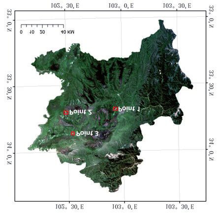
The UAV image data used for this study were First, we segmented the entire image at a pixel level
obtained in the field from July 9 to 10, 2019, as presented using chessboard segmentation algorithm and generated
in Fig. 2. The desertification problem highlighted as image object layer of Level 1. The parameter of object
three points in the figure is very serious. We obtained size was set to one. We extracted vegetation at Level 1
80 UAV images from the first point, 135 images from based on the NDVI index. The threshold value of NDVI
the second point and 68 images from third point. By was adjusted according to Landsat images. Second, we
using Photoscan software, we aligned the UAV images, used multiresolution segmentation algorithm to segment
Table 1. List of remote sensing image data.
Satellite Sensor Imaging Date Number of images Number of bands
Landsat 4 TM 1989 2 7
Landsat 5 TM 1990-2011 40 7
Landsat 7 ETM+ 1999-2011 21 8
Landsat 8 OLI 2013-2018 21 9
5792 Tu M., et al.
is marked as belonging to one of two categories. An
SVM object function is used to solve the optimization
problem as:
(1)
...where αs are the Lagrange coefficients and C is a
constant that is used to penalize the training errors
of the samples. SVM is affected by the selection of
regularization parameters αs and the form of the
kernel function K(xi, xj) [39]. In this study, we selected
the Gaussian Radial Basis Function (RBF) as the
Kernel function and used the Library for Support
Vector Machines (LIBSVM) to obtain the value of two
parameters for RBF. One parameter is the optimum
Gaussian radial basis function γ, which controls the
kernel width. Another is the regularization parameter C
Fig. 2. UAV aerial photography points. mentioned above.
The features used for classification were listed in
Table 2.
Results
Land Cover Classification and Accuracy
Assessment
We first classified the Landsat images from 2017 due
to this set offering the highest level of image quality.
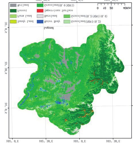
The mapped land cover classes of Zoige County in 2017
can be seen in Fig. 4 and include sandy land, farmland,
Fig. 3. The workflow of classification.
the unclassified parts and generated image object layer
of Level 2 at a larger object scale. The parameters of
shape and compactness were adjusted to acquire fairly
integrated image objects for different types of land
cover. We used the SVM and some additional features
to classify the remaining parts. Third, 1,000 random
sample points were selected to evaluate the classification
accuracy based on a confusion matrix.
SVM and Features Used for Classification
SVM is a supervised learning model derived from
statistical learning theory. The algorithm distinguishes
between classes with the decision that maximizes the
margin between them. Given a set of training examples,
{(xi, yi)}ni=1, and Kernel function K, each yi = {–1, +1} Fig. 4. Classification map of Zoige County in 2017.
Monitoring Grassland Desertification in Zoige...                                                                                      5793

Table 2. Features used for land cover classification.
  Textural features                Formulae                  Shape indices         Formulae           Thematic indices     Formulae

    Homogeneity                                                   LWI                                      NDVI

      Contrast                                                   Shape                                    NDWI

       Energy                                                    Edge                                      NDBI

      Entropy                                                                                               SBI

 Note: For Table 2, (i, j) are the coordinates in the co-occurrence matrix space; g(i, j) is the co-occurrence matrix value at that
 coordinate; N is the dimension of the co-occurrence matrix; L, W, P, A are the length, width, perimeter, area of an image object,
 respectively; NIR, R, G, B represent the value of near-infrared, red, green, and blue bands, respectively.

Table 3. Accuracy assessment of land cover classification in 2017.
                        Sandy       Farm                                 Water                              Impervious       User’s
         Class                                 Forest    Wetland                  Grassland Bareland
                        Land        Land                                 Body                                 Surface       Accuracy
     Sandy Land           25          0           0         0             4          1           3                0          75.76%
         Farm
                           0         25           2         3             0          5           0                0          71.43%
         land
        Forest             0          0         123         3             2          10          0                0          89.13%
       Wetland             0          0           0        117            14         13          0                3          79.59%
        Water
                           0          0           0         7             62         6           2                0          80.52%
        Body
      Grassland            3         15           7         19            13        428          5                2          86.99%
       Bareland            3          0           0         0             2          5           45               2          78.95%
     Impervious
                           1          0           0         0             0          3           2                15         71.43%
       Surface
 Producer’s accuracy 78.13%        62.5%      93.18%     78.52%       63.92%       90.87%     78.95%         68.18%
 Overall accuracy: 84%; kappa coefficient: 77.6%

forest, wetland, water body, bareland, and grassland                             Spatial-Temporal Distribution and Trend
with different coverage. The accuracy assessment of                                of Desertification in Zoige County
the land cover classification based on 1000 random
sample points is shown in Table 3. The overall                                From the perspective of the desertification’s spatial
accuracy is 84%, and the kappa coefficient is 77.6%.                      distribution, sandy lands mainly have concentrated
Some sandy lands were misclassified as bareland due                       in four contiguously zonal areas since 1990, as
to high similarity in the features of the image object.                   shown in Fig. 5. The distribution pattern of grassland
The accuracy assessment results indicate that we have                     desertification in Zoige County has remained stable
acquired a relatively objective land cover classification.                overall. The sandy land in No. 1 area is in MaiXi
We updated the land cover classification in other years                   Township, extending from northwest to southeast,
based on the 2017 data and extracted the corresponding                    and largely distributed along the peaks of Zaregama,
sandy lands.                                                              Adangqiao, Zarexiejian. No. 2 is in XiaMan
                                                                          Township, along Maidoganglan, Quruzhaka peaks.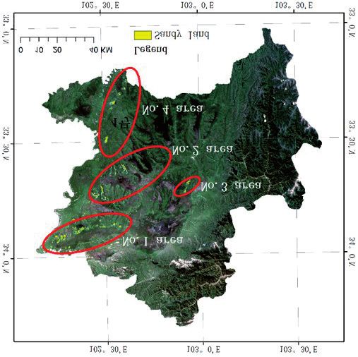
5794                                                                                                             Tu M., et al.

                                                                     the increase of grassland desertification area was
                                                                     mainly concentrated in No. 1 MaiXi Township, while
                                                                     the desertification area in No. 2 XiaMan Township
                                                                     decreased to a certain extent (Fig. 7b, c). From the
                                                                     overall time sequence (1990-2005), the increase of
                                                                     grassland desertification area mainly concentrated in
                                                                     No. 1 MaiXi Township (Fig. 7d). In addition, the sandy
                                                                     land area also increased to a certain extent in AXi
                                                                     Township of area No. 3 and TangKe Township of area
                                                                     No. 4.
                                                                         By comparing the changes of grassland
                                                                     desertification in Zoige County from 1990 to 2005, it
                                                                     can be seen that the increase in the area of grassland
                                                                     desertification is mainly manifested in two forms:
                                                                     the first is the outward expansion at the edge of the
                                                                     original desertified land (Fig. 8a); the second is the
                                                                     addition of spotty sandy patches (Fig. 8b). The increase
                                                                     of grassland desertification in Zoige County is mainly
                                                                     in the periphery of the original desertification patches,
                                                                     but there are a few newly increased desertification
Fig. 5. Spatial distribution of desertification in Zoige County.
                                                                     patches.
                                                                         During the eight years from 2005 to 2013, the
                                                                     grassland sandy land area in Zoige County decreased
No. 3 desertification area is in AXi Township, mainly
                                                                     rapidly to 22.58 km 2, with an average annual decrease
distributed in the vicinity of Xiemana, Xiemajan and
                                                                     of 3.04 km 2. The spatial change was shown in
Qumupeng peaks. No. 4 area is in TangKe Town,
                                                                     Fig. 9a). The trend led to a significant reduction in
extending from Xiedong Village in the northwest to the
                                                                     Zoige County’s sandy land area (Fig. 9b).
vicinity of Zeejian Mountain in the southeast.
                                                                         From 2013 to 2017, the sandy land area showed an
    Fig. 6 shows the area changes of sandy land in
                                                                     increasing trend, with a total increase of 11.03 km 2
Zoige County from 1990 to 2017. In recent 30 years, the
                                                                     and an annual increase of 2.76 km 2. The spatial change
changing trend of sandy land area within the grassland
                                                                     is shown in Fig. 10. During this period, there was
can be characterized by an “N” type variation structure.
                                                                     a trend of desertification in the areas land that had
    During a fifteen-year period from 1990 to 2005,
                                                                     been reclaimed by reforestation. The sandy land area
the sandy land area increased from 29.75km 2 to
                                                                     increased obviously, but there was still a slight decrease
46.87 km 2, with an average annual growth rate of
                                                                     in the sandy land area.
2.44% (about 1.14 km2). In the first decade, the sandy
land area increased steadily, while in the last five years
of this particular period, the sandy land area increased
                                                                                              Discussion
rapidly. From 1990 to 1994, the increase of sandy land
area in Zoige County was mainly concentrated in the
                                                                        Though the space-time evolution of grassland
XiaMan Township of the No. 2 area in the middle of
                                                                     desertification in Zoige County has been affected by
the county (Fig. 7a). During 1994-1999 and 1999-2005,
                                                                     many factors, the local natural environment conditions,

Fig. 6. The changing trend of sandy land area within the grassland in Zoige County from 1990 to 2017.
Monitoring Grassland Desertification in Zoige...                                                                            5795

Fig. 7. The temporal and spatial evolution process of sandy land from 1990 to 2005 in Zoige County. a) Sandy land changes from 1990
to 1994; b) Sandy land changes from 1994 to 1999; c) Sandy land changes from 1999 to 2005; d) Sandy land changes from 1990 to 2005.

Fig. 8. a) The outward expansion at the edge of the original desertified land; b) The addition of spotty sandy patches.

especially topography, wind direction, and water                        line in Fig. 11a). Valleys occupy the northeast of Zoige
resources distribution, are considered as the basic                     County. Water resources are abundant, and forest is the
factors of grassland desertification. We overlaid the                   main land cover in the area. However, there is not much
sandy land on the maps of a digital elevation model                     water in the southwest of Zoige County and grassland is
(DEM) and water resources distribution respectively,                    main vegetation type. The main wind direction in Zoige
as shown in Fig. 11(a, b). Obviously, Zoige County can                  County is southwest, northwest, and northeast. The
be divided into two parts by a mountain boundary (red                   mountains to the southwest are eroded by the prevailing
5796                                                                                                                Tu M., et al.

Fig. 9. a) The changes of grassland desertification area in Zoige County from 2005 to 2013; b) The local details of sandy land area
reduction from 2005 to 2013.

wind all year around. Due to the combined influence of              implemented the ‘National Sand Control Project Plan’.
physiographic factors, sandy land is mainly distributed             However, it was not until 1993 that XiaMan township
along the directions of the prevailing wind at the edges            under the jurisdiction of Zoige County was listed as
of mountains in the southwest. Thus, it can be assumed              one of the demonstration bases of the national sand
that physiographic characteristics of Zoige County                  control project. During this period, although China
determine the spatial distribution of sandy land.                   emphasized the importance of desertification control in
    In addition to natural factors, regional policy                 Zoige County, there was a lack in capital investment.
in desertification control plays an important role.                 From 1996 to 1999, a total of 2.8363 million yuan was
According to the Chinese desertification control polices            invested in desertification control in Zoige County. Since
and their related documents, the desertification control            1999, a relatively mature desertification management
in Zoige County started in the 1960s, but the control               model had been gradually promoted for application in
efforts were not strong. From 1991 to 2000, China                   Zoige County. Therefore, prior to 2005, desertification
                                                                    control measures existed in an exploratory stage for
                                                                    Zoige County was in the exploratory stage. Although
                                                                    some achievements were made, the desertification area
                                                                    continued to expand.
                                                                        After 2005, more relevant policies were made at the
                                                                    country level to carry out large-scale desertification
                                                                    control work in Zoige County. From the perspective of
                                                                    capital investment, the national grassland desertification
                                                                    control projects in Zoige County were funded by central
                                                                    finance and supported financially at the provincial and
                                                                    local level, with a large scale of capital investment.
                                                                    During this period, desertification areas have been
                                                                    managed and protected regularly, resulting in a rapid
                                                                    decrease of sandy land. The UVA images at No. 1 and
                                                                    No. 3 monitoring points are shown in Fig. 12(a, b),
                                                                    respectively. Obviously, the vegetation of desertification
                                                                    land was gradually restored.
                                                                        In recent years, however, the total area of grassland
                                                                    sandy land in Zoige County has presented an increasing
                                                                    trend. It was found from site investigation that some
                                                                    restored grassland returned once more to sandy land. In
                                                                    fact, the duration of protection for the restored grassland
                                                                    is usually three or five years and the surviving rate of
Fig. 10. The changes of grassland desertification area in Zoige
                                                                    artificial vegetation is very low, as shown in Fig. 12c).
County from 2013 to 2017.
Monitoring Grassland Desertification in Zoige...                                                                           5797

Fig. 11. a) The DEM and b) water resources distribution of Zoige County.

Fig. 12.a) UVA images at No. 1 monitoring point; b) UVA images at No. 3 monitoring point; c) UVA images at No.2 monitoring point.
5798                                                                                                             Tu M., et al.

                      Conclusions                               5. D’Odorico P., Bhattachan A., Davis K.F.,
                                                                    Ravi S., Runyan C.W. Global desertification: Drivers
    In Zoige County, desertification has been severe in             and feedbacks. Advances in Water Resources, 51,
                                                                    2013.
the last three decades. This work focused on the analysis
                                                                6. Lyu Y., Shi P., Han G., Liu L., Guo L., Hu X.,
of space-time evolution of grassland desertification                Zhang G. Desertification control practices in China.
in Zoige County based on Landsat and UVA imagery.                   Sustainability (Switzerland), 12 (8), 2020.
The results showed that the changing trend of the               7. Zhao H., Zhao Y., Gao G., Ho P. China’s
grassland sandy land area can be characterized by an                desertification deconstructed: towards a scientists’ model
“N” type variation structure. The area of sandy lands               based on long-term perceptions of grassland restoration
increased from 29.75 km2 in 1990 to 46.87 km2 in 2005               (1995-2011). Restoration Ecology, 26 (April), S26, 2018.
and then decreased to 22.58 km2 in 2013. However,               8. Song C., Schroeder T.A., Cohen W.B. Predicting
during 2014-2017, the area increased to 33.61 km 2.                 temperate conifer forest successional stage distributions
                                                                    with multitemporal Landsat Thematic Mapper imagery.
The local natural environment conditions, especially
                                                                    Remote Sensing of Environment, 106 (2), 2007.
topography, wind direction, and water resources                 9. Wang X., Hua T., Lang L., Ma W. Spatial differences
distribution, are considered as the basic factors of                of aeolian desertification responses to climate in arid Asia.
causing grassland desertification. The combined                     Global and Planetary Change, 148, 22, 2017.
influence of the physiographic factors determines the           10. Wei H., Wang J., Han B. Desertification Information
spatial distribution of sandy land. The sandy land in               Extraction along the China-Mongolia Railway Supported
Zoige County is mainly distributed along the directions             by Multisource Feature Space and Geographical Zoning
of the prevailing wind at the edges of mountains in                 Modeling. IEEE Journal of Selected Topics in Applied
the southwest. Regional policy and fund support play                Earth Observations and Remote Sensing, 13, 392, 2020.
                                                                11. Albalawi E.K., Kumar L. Using remote sensing
important roles in desertification control. It is clear
                                                                    technology to detect, model and map desertification:
that long-term protection works are necessary for the               A review. Journal of Food, Agriculture and Environment,
restored grassland. The results of the study are intended           11 (2), 2013.
to support policy makers as they consider future                12. Yang G., Chen D., He X.L., Long A.H., Yang M.J.,
directions for desertification control.                             Li X.L. Land use change characteristics affected by water
                                                                    saving practices in manas river basin, China using landsat
                                                                    satellite images. International Journal of Agricultural and
                  Acknowledgements                                  Biological Engineering, 10 (6), 2017.
                                                                13. Ahmady-Birgani                H.,     McQueen           K.G.,
                                                                    Moeinaddini M., Naseri H. Sand dune encroachment
   This research was funded by the Science and
                                                                    and desertification processes of the rigboland Sand Sea,
Technology Projects of Jiangxi Provincial Department                Central Iran. Scientific Reports, 7 (1), 2017.
of Education, grant number GJJ190934 and the Science            14. Qi X., Zhang C., Wang K. Comparing Remote Sensing
and Technology Project of Aba state, grant number                   Methods for Monitoring Karst Rocky Desertification at
19YYJSYJ0011.                                                       Sub-pixel Scales in a Highly Heterogeneous Karst Region.
                                                                    Scientific Reports, 9 (1), 1, 2019.
                                                                15. Wen Y., Guo B., Zang W., Ge D., Luo W., Zhao H.
                  Conflict of Interest                              Desertification detection model in Naiman Banner based
                                                                    on the albedo-modified soil adjusted vegetation index
                                                                    feature space using the Landsat8 OLI images. Geomatics,
   The authors declare no conflict of interest.
                                                                    Natural Hazards and Risk, 11 (1), 544, 2020.
                                                                16. Xu D., Kang X., Qiu D., Zhuang D., Pan J.
                                                                    Quantitative assessment of desertification using Landsat
                       References                                   data on a regional scale - a case study in the Ordos Plateau,
                                                                    China. Sensors, 9 (3), 1738, 2009.
1. Azzouzi           S.A.,   Vidal-Pantaleoni             A.,   17. Jiang Z., Huete A.R., Chen J., Chen Y., Li J., Yan
   Bentounes H.A. Monitoring Desertification in Biskra,             G., Zhang X. Analysis of NDVI and scaled difference
   Algeria Using Landsat 8 and Sentinel-1A Images. IEEE             vegetation index retrievals of vegetation fraction. Remote
   Access, 6, 30844, 2018.                                          Sensing of Environment, 101 (3), 2006.
2. Wei H., Wang J., Cheng K., Li G., Ochir A.,                  18. Julien Y., Sobrino J.A., Verhoef W. Changes in
   Davaasuren D., Chonokhuu S. Desertification                      land surface temperatures and NDVI values over Europe
   information extraction based on feature space                    between 1982 and 1999. Remote Sensing of Environment,
   combinations on the Mongolian plateau. Remote Sensing,           103 (1), 2006.
   10 (10), 1, 2018.                                            19. Guo B., Wen Y. An Optimal Monitoring Model of
3. Li J., Xu B., Yang X., Qin Z., Zhao L., Jin Y., Guo J.           Desertification in Naiman Banner Based on Feature Space
   Historical grassland desertification changes in the Horqin       Utilizing Landsat8 Oli Image. IEEE Access, 8, 4761,
   Sandy Land, Northern China (1985-2013). Scientific               2020.
   Reports, 7 (1), 1, 2017.                                     20. Yu H., Lee J.-Y., Lee W.-K., Lamchin M.,
4. Reynolds J.F., Mark D., Smith S., Lambin                         Tserendorj D., Choi S., Kang H.D. Feasibility of
   E.F., Ii B.L.T., Mortimore M., Walker B.                         Vegetation Temperature Condition Index for monitoring
   Global Desertification: Building a Science for Dryland           desertification in Bulgan, Mongolia. Korean Journal of
   Development. Science, 316, 2007.                                 Remote Sensing, 29 (6), 621, 2013.
Monitoring Grassland Desertification in Zoige... 5799
21. Lamchin M., Lee J.Y., Lee W.K., Lee E.J., Kim M., 31. Zhang Z., Ouyang Z., Xiao Y., Xiao Y., Xu W.
Lim C.H., Kim S.R. Assessment of land cover change and Using principal component analysis and annual seasonal
desertification using remote sensing technology in a local trend analysis to assess karst rocky desertification in
region of Mongolia. Advances in Space Research, 57 (1), southwestern China. Environmental Monitoring and
2016. Assessment, 189 (6), 2017.
22. Wu Z., Lei S., Bian Z., Huang J., Zhang Y. Study 32. Yang J., Weisberg P.J., Bristow N.A. Landsat
of the desertification index based on the albedo-MSAVI remote sensing approaches for monitoring long-term tree
feature space for semi-arid steppe region. Environmental cover dynamics in semi-arid woodlands: Comparison of
Earth Sciences, 78 (6), 2019. vegetation indices and spectral mixture analysis. Remote
23. Li F., Meng J., Zhu L., You N. Spatial pattern and Sensing of Environment, 119, 2012.
temporal trend of land degradation in the Heihe River 33. Somers B., Asner G.P., Tits L., Coppin P.
Basin of China using local net primary production scaling. Endmember variability in Spectral Mixture Analysis: A
Land Degradation and Development, 31 (4), 2020. review. Remote Sensing of Environment, 2011.
24. Sun J., Hou G., Liu M., Fu G., Zhan T.Y., Zhou 34. Feng G., Wang K., Yin D., Zou S., Wang L. How
H., Haregeweyn N. Effects of climatic and grazing to account for endmember variability in spectral mixture
changes on desertification of alpine grasslands, Northern analysis of night-time light imagery? International Journal
Tibet. Ecological Indicators, 107, 2019. of Remote Sensing, 41 (8), 2020.
25. Yang X., Yang T., Ji Q., He Y., Ghebrezgabher 35. Song C. Spectral mixture analysis for subpixel vegetation
M.G. Regional-scale grassland classification using fractions in the urban environment: How to incorporate
moderate-resolution imaging spectrometer datasets based endmember variability? Remote Sensing of Environment,
on multistep unsupervised classification and indices 95 (2), 2005.
suitability analysis. Journal of Applied Remote Sensing, 8 36. Yue Y., Zhang B., Wang K., Liu B., Li R., Jiao Q.,
(1), 2014. Zhang M. Spectral indices for estimating ecological
26. Jiang M., Tian S., Zheng Z., Zhan Q., He Y. Human indicators of karst rocky desertification. International
activity influences on vegetation cover changes in Beijing, Journal of Remote Sensing, 31 (8), 2010.
China, from 2000 to 2015. Remote Sensing, 9 (3), 2017. 37. Guo Q., Fu B., Shi P., Cudahy T., Zhang J., Xu
27. Higginbottom T.P., Symeonakis E. Assessing H. Satellite monitoring the spatial-temporal dynamics of
land degradation and desertification using vegetation index desertification in response to climate change and human
data: Current frameworks and future directions. Remote activities across the Ordos Plateau, China. Remote
Sensing, 6 (10), 9552, 2014. Sensing, 9 (6), 1, 2017.
28. Lian J., Zhao X., Li X., Zhang T., Wang S., Luo 38. Xu E.Q., Zhang H.Q., Li M.X. Object-Based Mapping
Y., Feng J. Detecting sustainability of desertification of Karst Rocky Desertification using a Support Vector
reversion: Vegetation trend analysis in part of the agro- Machine. Land Degradation and Development, 26 (2),
pastoral transitional zone in Inner Mongolia, China. 2015.
Sustainability (Switzerland), 9 (2), 2017. 39. Liu P., Choo K.K.R., Wang L., Huang F. SVM or
29. Feng Q., Ma H., Jiang X., Wang X., Cao S. What deep learning? A comparative study on remote sensing
Has Caused Desertification in China? Scientific Reports, image classification. Soft Computing, 21 (23), 7053, 2017.
5 (1), 1, 2015.
30. Piao S., Fang J., Liu H., Zhu B. NDVI-indicated
decline in desertification in China in the past two decades.
Geophysical Research Letters, 32 (6), 1, 2005.You can also read