Communities and Demographics
←
→
Page content transcription
If your browser does not render page correctly, please read the page content below
LOWER WINNIPEG RIVER BASIN DISCUSSION SHEET SERIES
Sheet #7

Communities and Demographics
                                                                                       May 2021

Introduction
The lower Winnipeg River basin (LWRB) is located in the northwest section of the entire
Winnipeg River basin (WRB), which spans parts of western Ontario and small parts of Manitoba
and northern Minnesota, United States. The Discussion Sheet Series highlights research
on ecological and socio-economic aspects of the basin to encourage discussion with experts,
government departments, Indigenous groups, and stakeholders. The Discussion Sheet Series is
based on available data collected in 2018 and 2019. Sheet 7 of 11 summarizes communities and
demographics in the LWRB.

Communities and Demographics
TOWNS
There are several towns and settlements located in the LWRB—Lac du Bonnet, Pinawa,
Powerview-Pine Falls, and Fort Alexander (or Sagkeeng First Nation) (Figure 1).

POPULATION
There are six census subdivisions partially or fully situated within the LWRB boundaries—
Powerview-Pine Falls, town (T); Alexander, rural municipality (RM); Lac du Bonnet, RM; Lac
du Bonnet, T; Pinawa, local government district (LGD); and Fort Alexander 3, Indian Reserve
(IRI) (Figure 2). Based on the data from Census 2016, the population within these subdivisions
grew from 11,839 in 2011 to 12,292 in 2016 (4% in five years) (Statistics Canada, 2017a,
2017d, 2017e).

Scenic landscapes of the Canadian Shield and proximity to Winnipeg and the mid-west United
States have resulted in major cottage developments and significant numbers of seasonal residents
and short-term visitors to the area. The population increases dramatically in summer months—
from 3,333 to 20,000 in the RM of Alexander (n.d.) and from 3,800 people to 8,000 in the RM
and Town of Lac du Bonnet (Scatliff Miller Murray, 2010).

© 2021 International Institute for Sustainable Development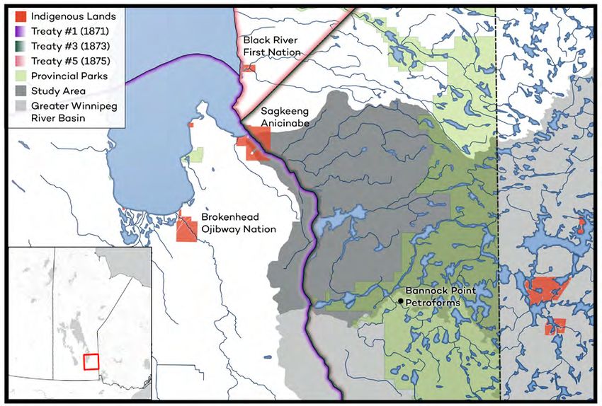
Communities and Demographics

DWELLINGS
There are 9,537 private dwellings across the five census subdivisions (Statistics Canada, 2017a,
2017d, 2017e). In the RM of Alexander and RM of Lac du Bonnet, less than half of the dwellings
are occupied by usual residents,1 pointing to a significant seasonal population, whereas in towns
(Powerview-Pine Falls, Lac du Bonnet, and Pinawa), almost all dwellings are occupied by usual
residents (around 90%) (Figure 3).

POPULATION DENSITY
The LWRB is a sparsely populated watershed with a low population density (Figure 3).
Population density is highest in towns and settlements like the Town of Pinawa (856 people per
km2), the Town of Lac du Bonnet (507 people per km2), and the Town of Powerview-Pine Falls
(262 people per km2) (Figure 3) (Statistics Canada, 2017a, 2017d, 2017e).

POPULATION MOBILITY
Some population mobility is also evident: between 17%–38% of the population in the basin were
living elsewhere five years prior to Census 2016 (Statistics Canada, 2017a, 2017d, 2017e). This
does not include Sagkeeng First Nation, where around 95% of the population were non-movers.
This can add to an understanding of the extent of people’s long-term knowledge of the watershed
and their attachment to the area.

FIRST NATIONS
One First Nation community (Fort Alexander First Nation/Sagkeeng Anicinabe) is located
within the LWRB’s boundaries, and two communities are located close to the basin (Little
Black River First Nation and Brokenhead First Nation) (Figure 4). Members of all three
First Nation communities historically used this area for hunting, wild rice harvesting, fishing,
trapping, and other traditional activities as sustenance and as a living. Important sites of
spiritual and cultural significance for the Indigenous Peoples in the region can be found in or
close to the LWRB, for example, Bannock Point Petroforms located in the Whiteshell Provincial
Park (Figure 4).

MÉTIS
Métis people are another Indigenous group that has traditionally used the lands of the basin to
hunt, fish, trap, and gather, and whose activities are tightly linked to water. Métis rights to harvest
natural resources for food and domestic use can be exercised in defined areas of Manitoba
indicated in the Métis Recognized Harvesting Area Map. This map is currently being expanded
and will include all of the LWRB (Manitoba Métis Federation, 2018).

1According to Statistics Canada (2019), “private dwelling occupied by usual residents” refers to a private dwelling in
which a person or a group of persons is permanently residing.

                                                                                                        IISD.org         2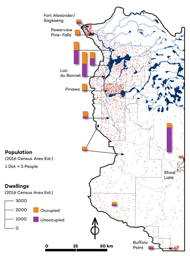
Communities and Demographics

   Population characteristics presented above—such as population growth rate, density,
   and mobility—not only inform land-use patterns necessary for planning, but they also
   provide critical insights into people’s culture and values, for example, their sense of
   place/attachment to a place. These are social factors to be considered in any research
   or planning initiative.

Figure 1. Map of the LWRB

 Communities
      1 Fort Alexander / Sagkeeng
      2 Powerview-Pine Falls
                                               1                  s
                                                              Fall
      3 Lac du Bonnet                                  Pine
                                                   2
      4 Pinawa

                                                                                                                er
                                                                                                                   v
                                                                       Great Falls                              Ri
                                                                                                          rd
                                                                                     Falls           Bi
                                                                               rthur
                                                                          McA
         Generating Station
                                                                                                                             nipeg R
                                                                                                                         W in        i ve r
         River/Stream            Lorem ipsum                                                                                      Eaglenest
                                                                      Lac du                                                      Lake
         Trans-Canada Highway                                 3       Bonnet                                           Point du
                                                                                                                           Bois
         Highway                                                                            Slave Falls

         Other Road                                            Seven                      eg Rive r
                                                                                 W i n nip
                                                               Sisters     4                      W
         Mainline Railroad                                                                          hi
                                                                                                      te
                                                                                                           sh
         Other Raiload
                                                                                                            el
                                                                                                              l
                                                                  W

         Water Quality Sites
                                                                  hit
                                                                     em
                                                                      ou
                                                                         th
                                                                          R.

                                               0                          25                       50 km
                                                                                                                       Canadia n Nation a l
                                                                                                                       Canadia
Source: Government of Manitoba, n.d.                                                                                           n P acifi
                                                                                                                                         c

                                                                                                                              IISD.org        3
Communities and Demographics
Figure 2. Census 2016 subdivisions partially and fully situated within the LWRB
Fort Alexander 3, IRI
Powerview - Pine Falls, T
Alexander, RM
Lac
du Bonnet, RM
Lac du Bonnet, T
Pinawa, LGD
0 25 50 km
Source: Statistics Canada, 2017b.
IISD.org 4Communities and Demographics
Figure 3. Population density and dwellings by subdivision map of the Manitoba portion of
the Winnipeg River basin in 20162
Source: Statistics Canada, 2017c; Government of Manitoba, n.d.
2 The population and dwellings information is scaled to the watershed boundary.
IISD.org 5Communities and Demographics
Figure 4. Map of Indigenous presence in the LWRB
Source: Natural Resources Canada, n.d.
References
Government of Manitoba. (n.d.). Manitoba Land Initiative. http://mli2.gov.mb.ca/
Manitoba Métis Federation. (2018). Map of the Expansion of the Recognized Metis Harvesting Area.
http://www.mmf.mb.ca/docs/harvesting/2018Resolution_RMHAExpansion_26Sept18.pdf
Natural Resources Canada (n.d.). Aboriginal Lands of Canada Legislative Boundaries. https://open.
canada.ca/data/en/dataset/522b07b9-78e2-4819-b736-ad9208eb1067
RM of Alexander. (n.d.). Our community. http://www.rmalexander.com/p/our-community
Scatliff Miller Murray. (2010). Lac du Bonnet Planning District Development Plan. Prepared for Lac
du Bonnet Planning District Board [By-Law No. 98-09]. http://rmoflacdubonnet.com/Home/
DownloadDocument?docId=384e4030-1f7b-4369-b182-28e1f2f5c326
IISD.org 6Communities and Demographics
Statistics Canada. (2017a, November 29). Alexander, RM [Census subdivision], Manitoba and
Powerview-Pine Falls, T [Census subdivision], Manitoba (table). Census Profile. 2016 Census.
[Statistics Canada Catalogue no. 98-316-X2016001]. https://www12.statcan.gc.ca/census-
recensement/2016/dp-pd/prof/index.cfm?Lang=E
Statistics Canada. (2017b). 2016 Census - Boundary files. https://www12.statcan.gc.ca/census-
recensement/2011/geo/bound-limit/bound-limit-2016-eng.cfm
Statistics Canada. (2017c). Dwellings Occupied by Usual Residents and Population in Dwellings (6)
of Canada, Provinces and Territories, Census Metropolitan Areas and Census Agglomerations, 2016
Census - 100% Data [Catalogue No. 98-400-X2016012]. https://www150.statcan.gc.ca/n1/en/
catalogue/98-400-X2016012
Statistics Canada. (2017d, November 29). Lac du Bonnet, T [Census subdivision], Manitoba
and Fort Alexander 3, IRI [Census subdivision], Manitoba (table). Census Profile. 2016 Census
[Statistics Canada Catalogue no. 98-316-X2016001]. https://www12.statcan.gc.ca/census-
recensement/2016/dp-pd/prof/index.cfm?Lang=E
Statistics Canada. (2017e, November 29). Pinawa, LGD [Census subdivision], Manitoba and
Lac du Bonnet, RM [Census subdivision], Manitoba (table). Census Profile. 2016 Census
[Statistics Canada Catalogue no. 98-316-X2016001]. https://www12.statcan.gc.ca/census-
recensement/2016/dp-pd/prof/index.cfm?Lang=E.
Statistics Canada. (2019). Dictionary, Census of Population, 2016. https://www12.statcan.gc.ca/
census-recensement/2016/ref/dict/index-eng.cfm
IISD.org 7© 2021 The International Institute for Sustainable Development
Published by the International Institute for Sustainable Development.
This publication is licensed under a Creative Commons Attribution-
NonCommercial-ShareAlike 4.0 International License.
INTERNATIONAL INSTITUTE FOR SUSTAINABLE DEVELOPMENT
The International Institute for Sustainable Development (IISD) is an award-winning
independent think tank working to accelerate solutions for a stable climate, sustainable
resource management, and fair economies. Our work inspires better decisions and sparks
meaningful action to help people and the planet thrive. We shine a light on what can be
achieved when governments, businesses, non-profits, and communities come together.
IISD’s staff of more than 120 people, plus over 150 associates and consultants, come from
across the globe and from many disciplines. Our work affects lives in nearly 100 countries.
IISD is a registered charitable organization in Canada and has 501(c)(3) status in the
United States. IISD receives core operating support from the Province of Manitoba and
project funding from governments inside and outside Canada, United Nations agencies,
foundations, the private sector, and individuals.
Head Office
111 Lombard Avenue, Suite 325 Tel: +1 (204) 958-7700
Winnipeg, Manitoba Website: www.iisd.org
Canada R3B 0T4 Twitter: @IISD_news
iisd.orgYou can also read


