COMMUNITY & SOCIAL INFRASTRUCTURE AUDIT - SHD RESIDENTIAL DEVELOPMENT - CAIRN HOMES PROPERTIES LIMITED - Squarespace
←
→
Page content transcription
If your browser does not render page correctly, please read the page content below
COMMUNITY & SOCIAL INFRASTRUCTURE AUDIT
                                                 FOR A

                  SHD RESIDENTIAL DEVELOPMENT
                                   ON LANDS LOCATED AT

                 PARKSIDE 4, PARKSIDE, DUBLIN 13

                                     PREPARED BY

                                          ON BEHALF OF

                CAIRN HOMES PROPERTIES LIMITED

         1
CONTENTS

1.    INTRODUCTION .................................................................................................................................................................................................. 3
2.    PROPOSED DEVELOPMENT .................................................................................................................................................................................. 4
3.    METHODOLOGY .................................................................................................................................................................................................. 5
4.    AREA DEMOGRAPHICS ........................................................................................................................................................................................ 6
5.    POLICY CONTEXT................................................................................................................................................................................................. 9
6.    OVERVIEW ........................................................................................................................................................................................................ 12
7.    OPEN SPACE AND SPORT ................................................................................................................................................................................... 14
8.    EDUCATION ...................................................................................................................................................................................................... 16
9.    COMMUNITY FACILITIES .................................................................................................................................................................................... 23
10. RETAIL FACILITIES ............................................................................................................................................................................................. 25
11. HEALTH SERVICES.............................................................................................................................................................................................. 28
12. EMERGENCY SERVICES ...................................................................................................................................................................................... 29
13. PUBLIC TRANSPORT .......................................................................................................................................................................................... 29
14. FUTURE DEVELOPMENTS                                                                                                                                                                                              30

15. CONCLUSIONS                                                                                                                                                                                                      30

                                                                                                         2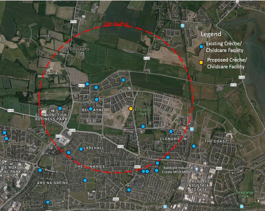
1.     INTRODUCTION
McGill Planning limited, 45 Herbert lane , Dublin 2 has been instructed by our client Cairn Homes Properties Limited, 7 Grand Canal, Grand Canal Street Lower,
Dublin 2, to prepare this Community and Social infrastructure Audit regarding the proposed Strategic Housing Development at a site of c.3.17Ha in area on
Parkside 4, (former Balgiffin Park Lands) Parkside, Dublin 13, consisting of 282 residential units in 4 apartment blocks ranging in height from 3-7 storeys.

This report will assess the existing and proposed community and social infrastructure in the area. These range of services contribute to the quality of life of
the residents of the area. They are facilities that will form elements to the key fabric of the area in terms of social, physical and mental well-being of the
community. This study has conducted a set of inventories that assessed the availability and quality of the services for the application site in relation to
education, childcare, community facilities, healthcare and other facilities. These services have been mapped for a 20 minute walk time, 5 minute drive time
catchment and 1 km buffer of the site.

Figure 1 Site location source Google maps 2019                                 Figure 2 Parkside development masterplan phasing Source: MCORM

                                                                              3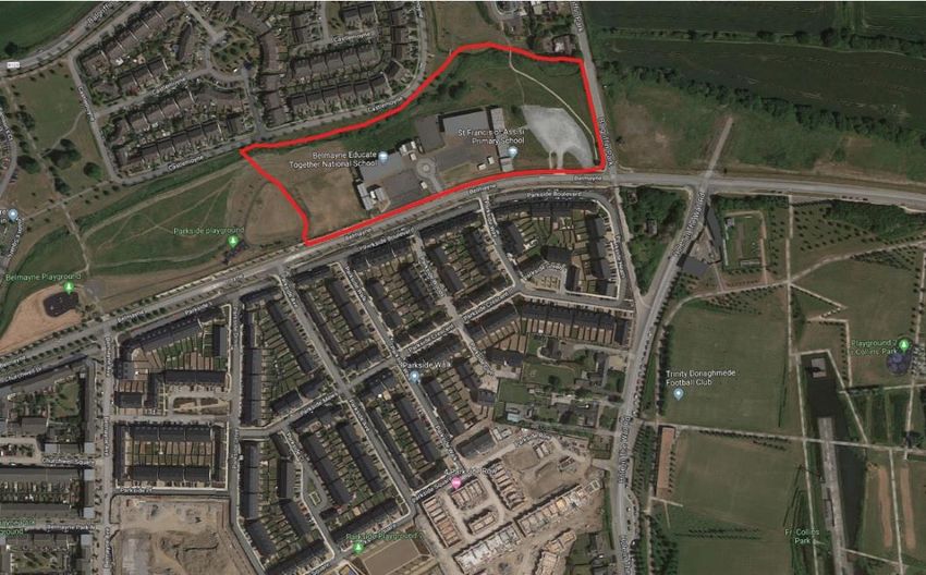
The proposed scheme is located to the south of River Mayne and north of Parkside Boulevard. The site follows on from earlier phases of development by
Cairn Homes Properties Limited in the area as part of the Parkside Development, which is located on the opposite side of Parkside Boulevard to this application
site. The application site is currently vacant following the relocation of the two primary schools which had been located on this site temporarily until April
2019. The Department of Education has transferred the schools to a new campus located to the south-east of the site. To the north of the subject site, is
Mayne River and further to the north is the Castlemoyne housing estate. To the east is Balgriffin Park road and further east the new 6 storey apartment
development (ABP Reg Ref 304448-19 and DCC Reg Ref 2295/19). To the west is open space. The subject site is also located to the west of Fr Collins Park. The
land is located within the Grange A Electoral Division.

The site is easily accessible by car, foot, cycle and public transport. There are 5 no. bus routes in the vicinity of the site that serve the area of Belmayne,
Parkside and Clongriffin estates which include routes 42, 43, 15, 27 and 27x. Routes 42 and 43 are accessible from Malahide Road west of the Balgriffin estate,
routes 15, 27 and 27x accessible from the R139 located south of Parkside, route 15 from Hole in the Wall Road and also serves the Clongriffin Dart station.

The site is located within the Clongriffin-Belmayne Local Area Plan 2012 – 2018 which has identified considerable progress in delivering key infrastructure,
including:

     •   C. 3,400 residential units
     •   C. 41,000 sq.m. of commercial floor space
     •   Clongriffin Railway station and No. 15 Bus Service
     •   Park and Ride facility at Clongriffin
     •   Two primary Schools (Educate Together and St Francis of Assisi)
     •   Fr Collins Park

2.       PROPOSED DEVELOPMENT
The proposed development will comprise a residential scheme 282 residential units in 4 apartment blocks ranging in height from 3 to 7 storeys in height. The
development will include 94 no. 1 bed apartments, 8 no. 2 bed (3 person) apartments, 167 no. 2 bed apartments (4 person) and 13 no. 3 bed apartments.
Apartments will have north/south/ east/ west facing balconies/ terraces. The proposed development also includes residential amenity facilities (530sqm)
incorporating concierge, media centre, and gymnasium. 277 no. car parking and 289 no. cycle parking spaces will be provided in the basement along with

                                                                              4
basement stores, plant, waste management areas, motor bike spaces and EV charging points. There will be an additional 134 no. surface cycle parking for
visitors along with 9 no. surface car parking.

The proposed development provides for the continuation and completion of the Mayne River Linear Park as well as public open space and communal open
spaces between the buildings.

A full description of development is set out in the statutory planning notices.

3.    METHODOLOGY
In order to assess the context of the subject site, a geospatial survey was undertaken to determine the current population demographics and if the future
population demands from the proposed development can be met by relevant services in the study are. The following datasets were used for this assessment:

        2016 CSO statistics
        2019 Google maps
        2019 Major Projects, Dept. of Education and Skills
        2019 Pobal Childcare Facility Inspection Reports
        2019 Address points (My Plan)
        2019 Dublin City Council Childcare Committee
        2019 HSE facilities
        2019 NaPTAN routes
        2019 Geohive maps
        2019 OSM Ireland on ArcGIS
        2019 OSI Base maps

                                                                                  5
4.     AREA DEMOGRAPHICS
Around 9,696 people were estimated to be living in the Grange A Electoral Division (02059) on the night of the 2016 census. The area has seen an increase in
population by c.8.3% between 2011 and 2016 census. The analysis of CSO data has shown that there is a very strong representation of working age population
within the 19-65 age group and a very robust representation of under 18 age group at 31% share of the population.

The analysis of CSO data showed that the population was ageing with a 45.5% increase in population over the age of 65, an increase of 9.5% in the population
of older adults (35-64 years old) and a decrease of 6.5% for young adults (19-34 years old).

Figure 3 Age profile Grange ED Source CSO

                                                                             6
Figure 4 Changing population trend for Grange A ED Source CSO

 2011       2016                   Population Change Percentage Change
 Population Population             2011-2016         2011-2016
 8,948      9,696                  748               8.3%

Table 1 CSO Data of the Grange A Electoral Division

                                                                         7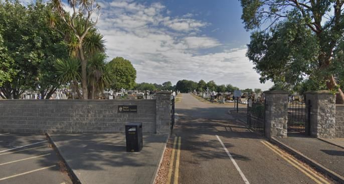
Age                            2011                    2016    Change       Percentage Change
     0-4 Pre-school                       817                     837      +20              +2.38
  5-18 School Children                   1,987                   2,198    +211               +9.6
      19-34 Adults                       2,436                   2,286    -150               -6.5
      35-64 Adults                       3,327                   3,676    +349               +9.5
       65+ Adults                         381                     699     +318              +45.5

Table 2 Age Groups CSO Data of the Grange A Electoral Division

                                                                                  8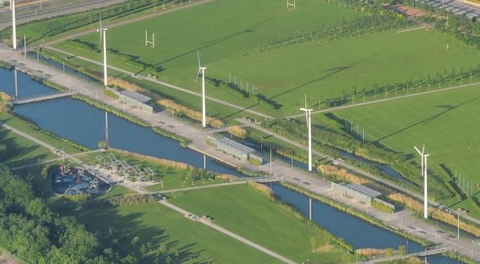
5.    POLICY CONTEXT
The Balgriffin Park lands are located within the North Fringe, identified in the Governments Rebuilding Ireland strategy as one of the four key sites within
Dublin City Council to deliver significant residential development of up to 7000 units. The North Fringe (including Clongriffin and Belmayne) is zoned Z14 and
designated as SDRA 1. The zoning objective is “To seek the social, economic and physical development and/or rejuvenation of an area with mixed use, of which
residential and “Z6” would be the predominant uses.” Residential is permitted under this zoning.

Sustainable Residential Development in Urban Areas Guidelines by the DoEhLG in 2009 states that:
        “Sustainable neighbourhoods require a range of community facilities, and each district/neighbourhood will need to be considered within its own wider
        locality, as some facilities may be available in the wider area while others will need to be provided locally. In this context, planning authorities should
        seek to ensure that facilities for social and cultural use, such as community centres, and personal and community development, such as resource
        centres, are available within the wider community.”

Dublin City Council Development Plan 2016 ‘require that larger schemes which will be developed over a considerable period of time are developed in
accordance with an agreed phasing programme to ensure that suitable physical, social and community infrastructure is provided in tandem with the
residential development and that substantial infrastructure is available to initial occupiers’(QH9). In accordance with it, this site has been assessed concerning
the existing communal facilities and infrastructure available. Although there are significant projects in the pipeline for retail and community infrastructure.

Goal 5 of Dublin City Local Economic and Community Plan 2016 – 2021 seeks to provide and protect a range of public, safe and affordable amenities, activities
and facilities that are relevant and accessible to people of all ages and abilities and that contribute to the health and well-being of all.

The Clongriffin Belmayne LAP 2012 has several chapters which focus on community facilities, retail, the Environment and Open Space Amenity Strategy and
also the Community and Social Infrastructure. These chapters enable the delivery of Dublin City Council’s aim to create a neighbourhood which promotes the
principles of active citizenship and civic responsibilities and ensure the development of sustainable communities through the provision of sustainable social
infrastructure that ensure the optimum use of community facilities. The facilities include the creation of a planned town square, a library, community centre,
permanent schools, sports, leisure and medical facilities. The objective of the LAP is to ensure that as undeveloped lands are developed the social and
community facilities are delivered in a timely and sustainable manner.

                                                                                9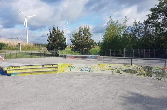
SITE LOCATION

Figure 5 Extract from the LAP indicating public open space provision for the area

                                                                                    10
Figure 6 Extract from the LAP indicating the integration of community services in the area
The following sections assess all the community and social infrastructure facilities already available within 5- and 10-minute drive time catchment of the site.
As is noted by the map above a key objective of the Clongriffin Belmayne LAP is to ensure that the existing and future community services are well connected
for future residents and users of the area either by foot or by bicycle.
116. OVERVIEW
The subject site is located on the opposite side of the Parkside development lands. The application site is part of the same ownership as Parkside Development
and is one of 3 sites yet to be completed in this area. The proposed scheme will provide the central section of the Mayne River linear park that follows the
Mayne river and enables the formation of future green infrastructure linkages between Baldoyle, Clongriffin, Belmayne and Northern Cross sites as required
within the Clongriffin -Belmayne LAP. This area will provide an attractive area to walk, cycle, playground and kick about area.
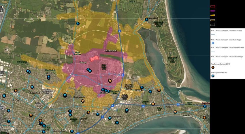
As part of this study, the existing community and social infrastructure in the study area have been located on the following map and listed in the table below.
The available facilities are described in much detail in the following sections.
CATEGORY DESCRIPTION
Open space and sports Parks, Playgrounds, Pitches, Green areas, Golf courses,
Sports centres, Gyms
Education Primary schools, Post Primary schools, Special schools,
Third level universities, other educational institutions
Community facilities Community Centres, Religious Facilities, Post Offices,
Libraries, Cemetery
Retail services Supermarkets, Convenient shops, Speciality services,
Restaurants/Take aways, ATM, Petrol station
Health Hospitals, Health centres, Clinics, Pharmacies, Addiction
services, GPs, Mental health services
Emergency Fire station, Garda station
Table 3 Classification of community facilities
12Figure 7 Community and Social infrastructure overview
137. OPEN SPACE AND SPORT
The subject site is located in close proximity to parklands, green areas and playing pitches. The proposed scheme includes provisions for a significant level of
public open space at the rate of c.16,900sqm as part of the river Mayne linear park and links to Parkside Boulevard. The Mayne River linear park provides for
children’s play areas as well as a pleasant walk/ cycle along the river connecting the spaces. The site is located to the north-west of Fr. Collins park an upcoming
area with running tracks and several playgrounds.
As well as public parks, there are a number of GAA sporting clubs with associated pitches located within the 1km radius of the site, which includes Trinity
Donaghmede Football Club, O’Tooles GAA, Trinity Gaels GAA and Inis Fail GAA. There is also the Trinity Sports & Leisure Club which includes a swimming pool,
and gym’s including Fit4less by energie, Body Transformation Studio, Mind Over Matter Fitness Studios, K & M Fitness Studio and Curves Suttonhowth.
The following open space and sports facilities are in the area
Open space and sport facilities Distance Facility name Description
Open Space, playgrounds, 0m Mayne River Linear Park Green space, multiple playgrounds
wetland walk and parks
Open Space, playgrounds and 350m Fr. Collins Park Green space, multiple playgrounds, skate park, football club, playing
Parks pitches
Open space 1km Temple View Green open space Open Space
Open space 1km Old Grange Abbey Monastery Open space
Open space 1.4km Donaghmede Park Park
Open space 1.4km Donahies Field Park
Open space 1.75km Darndale Park Green areas with water feature, running / cycling tracks, playing pitches
Gym 2km Mind Over Matter Fitness Studios Gym
Playground 180m Castlemoyne Playground Playground
Playground 200m Parkside playground Play area with running/cycling track and outdoor gym
Playground 350m Belmayne Playground Playground
Playgrounds 525m Belmayne Park Playground Playground, Basketball half court
Sports club 350m Trinity Donaghmede Football Club Sports club
Sports club 650m Trinity Gaels GAA GAA club with playing pitches
Sports centre 700m Trinity sports and leisure club 25m swimming pool, pool table, boxing club, indoor football, sports hall
14Sports complex 1.7km O’Tooles GAA Sports club with clubhouse, training courses, playing pitches
Gym 1.1km Énergie Fitness Clarehal Gym
Gym 1.2km Body Transformation studio Gym
Gym 1.2km Innisfails bowls club Bowling, GAA
Gymnastics centre 1.65km Arabian Gymnastic centre Gymnastics
Gym 1.7km Hurricane Fitness Gym
Gym 1.75km K&M Fitness studio Gym
Gym 1.92km Passon studios Gym
Leisure centre 2.5km St. Michael’s house Swimming pool, leisure centre
Sports cenre 2.7km Baldoyle community centre Dance classes, fitness coaching, yoga classes, Drama and art lessons
Pitch and Putt 2.9km Belcamp 9 Hole Pitch and putt
Golf club 2.75 Portmarnock Golf club Golf course
Golf club 2.9km Malahide Golf Club Golf course
Park with pitch and putt 2.9km Edenmore Park Pitch and putt course
Golf club 3.5km Sutton Golf club Golf course
Park and garden 4km Malahide castle and gardens Historic castle and gardens
Table 4 List of Open space and sports facilities
15Figure 8 Fr Collins Park, Clongriffin skate park (Source Google images 2019)
8. EDUCATION
The site is comfortably located within the existing school network serving the North Dublin. There are over 20 primary schools located within a 10-minute
drive time catchment of the site. 6 of them are located within a walkable distance of the site. There are 10 secondary schools located in the 10-minute drive
time catchment of the site. Of this Grange community college and Gaelcholáiste Reachrann are located within walkable distance of the site. The school
enrolment data shows that the proposed development and the population generated can be accommodated comfortably within this existing school network
for the locality.
The Parkside 2C development (Permission Granted Reg. Ref. 3486/17) includes the provision of 507 sq.m. 2 storey Crèche which can enrol a c. 117 children.
An analysis of existing childcare facilities in the local area as detailed in the table (below) using the data from Pobal (www.pobal.ie), shows that there are 23
no. childcare facilities operating within the chosen catchment area c. 1km radius from the subject site.
On third level education centres the site is within accessible distance of the best universities in the country. Dublin City University (6.5km), Trinity College
Dublin(9.2km), DIT Grangegorman (11.2km) and University College Dublin(12km) are all within the commuting range of the site.
16It is also worth noting that currently planning permission under DCC Reg Ref 3009/19 is being sought for the development of the provision of 2 schools for a
period no longer than 5 years. A temporary post-primary school by way of construction of 3no. single storey prefabricated buildings and a primary school of
2no. single storey prefabricated buildings is being sought. This is currently at Further Information Stage.
Figure 9 Location of Primary and Post primary schools
17PRIMARY SCHOOLS
Roll Official School Name Address 1 Address 2 Ethos/Religion FEMALE MALE TOTAL
Number
1 20308Q BELMAYNE EDUCATE TOGETHER Balgriffin Park Belmayne MULTI 224 218 442
DENOMINATIONAL
2 20304I ST FRANCIS OF ASSISI NS Belmayne Balgriffin CATHOLIC 237 218 455
3 19538D ST KEVINS JUNIOR N S NEWBROOK AVE DONAGHMEDE CATHOLIC 86 112 198
4 19611K SCOIL NAOMH COLMCILLE NEWBROOK RD DONAGHMEDE CATHOLIC 91 94 185
5 19406J HOLY TRINITY SEN N S GRANGE ROAD DONAGHMEDE CATHOLIC 168 188 356
6 19473B SCOIL BHRIDE GRANGE ROAD DONAGHMEDE CATHOLIC 204 219 423
7 19471U ST PAULS JUNIOR NATIONAL SCHOOL AYRFIELD MALAHIDE RD CATHOLIC 116 110 226
8 19618B ST PAULS SEN NS AYRFIELD MALAHIDE RD CATHOLIC 100 129 229
9 19524P OUR LADY IMMAC SEN N S DARNDALE CATHOLIC 93 87 180
10 19454U DARNDALE NS JUNIOR DARNDALE CATHOLIC 118 110 228
11 19668Q ST FRANCIS SENIOR N S PRIORSWOOD DUBLIN 17 CATHOLIC 97 90 187
12 17104G ST FRANCIS JUNIOR NATIONAL SCHOOL Clonshaugh Drive Priorswood CATHOLIC 95 110 205
13 19913D ST JOSEPHS NS MACROOM ROAD BONNYBROOK CATHOLIC 156 196 352
14 19920A ST JOHN OF GOD N S KILMORE ROAD ARTANE CATHOLIC 176 176
15 18362K S N CAITRIONA NAIONAIN COOLOCK DUBLIN 5 CATHOLIC 126 110 236
16 18361I S N CAITRIONA C COOLOCK DUBLIN 5 CATHOLIC 202 202
17 19777V GAELSCOIL MIDE Bóthar an Ghleanntain Cill Bharróg CATHOLIC 112 126 238
Ghlais
1818 19954R NORTH BAY EDUCATE TOGETHER NS GREENDALE AVENUE KILBARRACK MULTI 101 115 216
DENOMINATIONAL
19 19393D MHUIRE IOSEF JUNIOR Verbena Avenue, Sutton CATHOLIC 204 207 411
20 19533Q S N MUIRE AGUS IOSEF Verbena Ave Bayside CATHOLIC 211 226 437
21 09642P BURROWS N S Howth Road Sutton CHURCH OF IRELAND 114 112 226
22 20437E ST LAURENCE'S NATIONAL SCHOOL BROOKSTONE ROAD, BALDOYLE, CATHOLIC 213 233 446
23 20445D MALAHIDE PORTMANOCK EDUCATE MALAHIDE ROAD, MULTI 196 218 414
TOGETHER NATIONAL SCHOOL (Please DENOMINATIONAL
note this has Stage 1 extension agreed
with DOE)
Schools within 20-minute walk time catchment highlighted
Schools within 5-minute drive time catchment highlighted
Table 5 List of Primaryschools and their enrolment for 2019( Source DoE)
POST PRIMARY SCHOOLS
Roll Official School Name Address 1 Address 2 Ethos/Religion FEMALE MALE TOTAL
Number
1 91325R Malahide Community School Broomfield Malahide INTER 604 611 1,215
DENOMINATIONAL
2 91324P Portmarnock Community School. Carrickhill Road Portmarnock INTER 415 516 931
This has an extension about to DENOMINATIONAL
commence
3 60021U St Marys Secondary School Baldoyle Dublin 13 CATHOLIC 300 300
4 91342R Pobalscoil Neasáin Baldoyle Dublin 13 INTER 288 483 771
DENOMINATIONAL
195 70020B Grange Community College Grange Road Donaghmede INTER 77 153 230
DENOMINATIONAL
6 91318U The Donahies Community School Streamville Road Dublin 13 INTER 232 249 481
DENOMINATIONAL
7 60550B Chanel College Coolock Village Malahide Road CATHOLIC 598 598
8 60291D Árdscoil La Salle Raheny Road Raheny CATHOLIC 79 110 189
9 ST. FINTAN'S HIGH SCHOOL This CATHOLIC 706
has an extension due to be agreed
60370W with DOE DUBLIN ROAD, SUTTON, 706
10 GAELCHOLÁISTE REACHRANN. This
has an extension agreed with the BÓTHAR MHAINISTIR DOMHNACH INTER
76085N DOE NA GRÁINSÍ, MÍDE, DENOMINATIONAL 216 192
11 Donaghmede Howth - This is a new Baldoyle Stapolin
school which will be opened in
TBC 2021
Schools within 20-minute walk time catchment highlighted
Schools within 5-minute drive time catchment highlighted
Table 6 List of Post Primary schools and their enrolment for 2019( Source DoE)
20Figure 10 Location of Creche/Childcare services
21Crèche/Childcare Facility Total no. Children Services Offered
Giraffe Childcare Northern Cross No Response Full Day Care
Little Rainbows 96 Full Day Care
Little Blossoms Crèche 33 Full Day Care
Bumblebees 55 Full Day Care
Learning Circle Childcare 32 Full Day Care
The Learning Circle 60 Full Day Care
Tigers Childcare Balgriffin 85 Full Day Care
Ciara’s Playschool 22 Sessional
Lovable Me Montessori 44 Sessional
Pipalong Childcare 44 Sessional/After school
Madeline’s Preschool 20 Not provided
Children’s Choice 34 Full Day Care
Coraline’s Playschool 16 Sessional/After school
Fizzy Fingers 22 Sessional
Mead Day Care Centre 55 Part Time
Steppingstone 14 Sessional
Little Jesters Playschool 16 Sessional
Ayrfield Community Playgroup 16 Sessional
The Kids Den Preschool 40 Full Day Care
Learn and Play Preschool and Afterschool 22 Part Time
CLG
Darndale Belcamp New Life Centre LTD 36 Afterschool
Darndale/Belcamp Integrated Childcare 234 Full Day Care
Service
Drumnigh Montessori Primary School 44 Sessional
Total 1,040
22Parkside Phase 2C Proposed 507 sq.m. 2 117 Full day care
storey Crèche (Permission Granted Reg.
Ref. 3486/17)
Table 7 List of Childcare centres for the catchment area
9. COMMUNITY FACILITIES
The subject site is well located concerning existing community and social service facilities with facilities within the 1km radius, including the Donaghmede
Library, Trinity Sports and Leisure Club, Balgriffin Cemetery, and Fingal Cemetery. There are a number of Cultural Facilities located within the area which are
located more than 1km away. The existing facilities further afield include 3 no. of post offices including Clarehall An Post, Donaghmede An Post and Baldoyle
An Post, 2 no. of Churches which include St Paul’s Church and Church of the Holy Trinity and 2 no. men’s sheds which include Ayrfield Men’s Shed and
Donaghmede Men’s Shed. Many of these services can expand to accommodate future demand from the proposed developments. In addition to this, there
are several community facilities that are still in the pipeline waiting to be constructed or permitted. The area is also well serviced with respect to religious
and community centres.
Currently Unit 60 on Main street of Clongriffin serves as a temporary site as a community centre. The Belmayne avenue/Main street junction has a 2 storey
building that is currently vacant that has an extant permission for library use.
Community facilities Distance Facility name
Community gathering space 700m Trinity sports and leisure club
Special needs centre 2.5km St. Michaels house
Family Resource Centre 3.2km Artane Coolock
Library 1.4km Donaghmede library
2.8km Baldoyle library
Community hall 1.4km Donaghmede Men’s Shed
1.5km Ayrfield Men’s Shed
2.7km Baldoyle community hall
23Religious centre 1km St Doulagh’s church
1.15km Islamic Centre Clongriffin
1.3km Church of the Holy trinity
1.7km St Pauls Catholic church, Aryfield
1.95km Church of Our Lady Immaculate
2.7km St Peter& Paul Catholic Church
Post offices 1.2km Clare hall shopping centre
1.4km Donaghmede shopping centre
1.5km Baldoyle industrial estate
2.3km Willie Nolan road
2.2km Killbarrack post office
Cemetery 700m Fingal cemetery
1.25km Balgriffin cemetery
Table 8 List of Community facilities
Figure 11 St Michaels house, Trinity sports and leisure club, Fingal cemetery (Source Google images 2019)
2410. RETAIL FACILITIES
There are a number of retail units available for the site to the South of Parkside Boulevard along Main street and Northern Cross. There are current applications
for retail facilities within the locality. There are 3 no. of Retail Facilities located within the 1km radius of the subject site. Clarehall Shopping Centre is located
within the 1km radius, whilst Donaghmede Shopping Centre and Malahide Road Shops are located just outside this boundary. Further development of the
Belmayne and Clongriffin Town Centres will provide more retail services within a closer proximity to the Parkside development. Existing retail facilities within
the 10 minute drive time catchment are listed below:
Retail facilities Distance Facility name
Retail outlets 550m ToTu Belmayne
840m Centra Clongriffin
900m SPAR Clare hall
925m Eurospar, Malahide road
950m Meadows and Byrne
1.12km Clare hall shopping centre
1.3km Tesco Click and collect
1.4km Donaghmede shopping centre
1.6km G&J Hickey
ATM 800m AIB ATM Cliongriffin
950m Your Money kiosk ATM, Clare hall
900m Bank of Ireland, Malahide road
1.12km Clare hall shopping centre
1.4km Cash Zone ATM, Clare hall
Petrol station 1.83m Applegreen, Grange road
2.37km Circle K Balgriffin
Restaurants 650m Romayos Belmayne
650m Robertos Pizza
750m Park Lane chinese
1km Burnells square
1.1km Eddie Rockets, Clare hall
251.2m Kays Kithen
1.03km Romayos diner, Clongriffin
1.42km McDonald Donaghmede
Table 9 List of Retail facilities
Within the ‘Economic & Retail Study 2018 – Belmayne & Clongriffin’ prepared by AECOM Ltd it is envisaged that the Main street will link the two Key District
centres at Belmayne and Clongriffin to create a retail corridor. The Key District Centres where found to have capacity to facilitate another supermarket
development ideally once the vacant supermarket in Clongriffin is occupied. It is also anticipated that the area can accommodate another 4582sqm of
comparison goods floorspace by year 2027. Although there are high levels of vacancy within the locality, as well as extant permissions for major retail
developments, it has been found that there is scope to develop further economic and retail development in the area within the AECOM study. However, it
emphasised within the study that more residential development is required for retail developments to be viable in the area and to reduce the current vacancy
levels within Key District Centres and Main street.
26Figure 12 Retail and Economic sites within Belmayne and Clongriffin (Source: ‘Economic & Retail Study 2018 – Belmayne & Clongriffin’)
SITE
2711. HEALTH SERVICES
The subject site is located within a network of exiting health services that range from National Hospitals, GPs, Health centres, pharmacies etc. These services
have been listed according to their distance below.
Health Services Distance Facility name
Hospital 3km St. Joseph’s Hospital
4km Beaumont Hospital
Health centre/ GP 950m Northern Cross medical centre
1.12km Clongriffin medical centre
1.2km The meridian Clinic Clarehall
1.5km Dr Enda Casey
1.52km Dean Clinic
1.54km Grange clinic
2.06km Darndale health centre
2.23km Baldoyle GP
2.6km Baldoyle Medical
3.6km HSE Dublin North East Health centre
Pharmacy 900m Limitless Health pharmacy
1.1km Stacks Pharmacy
1.2km McCabes pharmacy, Clare hall
1.5km Donaghmede Allcare pharmacy
1.5km Boots Donaghmede
2km Darndale pharmacy
Table 10 List of Health facilities
It is expected that as the population grows in this area that more medical/ GP practices will open up as it will become a more viable and sustainable. Currently
the local area could benefit from an increased provision in the area. It.
2812. EMERGENCY SERVICES
The subject site is located at a reasonable distance of emergency and rescue services.
Emergency Services Distance Facility name
Fire station 1.8km Kilbarrack Fire station
Garda station 3km Coolock Garda station
3.3km Raheny District Garda Station
Table 11 List of Emergency services available for the site
13. PUBLIC TRANSPORT
The subject site is located within proximity to the Clongriffin Dart Station which services Dublin to the South and Commuter services to the North. There are
also 5 no. of bus routes located within walking distance of the Parkside lands, and a further 4 no. routes which are located just outside the 1km radius.
Bus routes include:
• 42 - Talbot St. To Sand's Hotel (Portmarnock)
• 43 - Talbot St. Towards Swords Business Park
• 32 - Talbot St. To Malahide
• 32x - Malahide Towards UCD Belfield
• 42d - DCU Towards Portmarnock
• 15 - Clongriffin To Ballycullen Rd
• 27 - Clare Hall To Jobstown
• 27x - UCD Belfield To Clare Hall
• 29a - Lower Abbey St. To Baldoyle (Coast Rd.)
2914. FUTURE DEVELOPMENTS
There are a number of extant permissions for retail development within the Clongriffin Belmayne LAP area. To the east of the site at Clongriffin Key District
Centre, will have a main square, and links to the train station, there are current planning applications (ABP – 305316, ABP -305319 and DCC Reg Ref. 3894/19)
seeking permission for the construction of c.22,727.5 sqm. of commercial development which will include:
• 30 no. retail units (c.791 sqm.)
• 10 floors of offices (c.3,732 sqm.)
• 7 no. café/restaurant (c.78 sqm.)
• 5 floors of offices within Block 13 (c.4,736 sqm.)
Another site in the Clongriffin area has currently c.13,950 sqm. of commercial development (DCC Reg Ref 0132/02, 5945/04, 3195/05) which includes 73 retail
units, a supermarket, offices, hospital, clinic, pharmacy, banks, restaurants, and a cinema complex is completed but some of which is vacant.
15. CONCLUSION
The site is well located with regard to proximity to existing community and social infrastructure. There are existing vacant commercial buildings along with
current applications in the pipeline for major retail and community facilities for the locality. It is considered that there is ample provision both existing and
proposed for the majority of the community, recreation, educational and social infrastructure within the surrounding area of the site. It is expected that once
more residential and commercial space is completed and with a greater population, more of these facilities will open in the area.
It is also worth noting that the site cannot be assessed in isolation with respect to the services available in the immediate locality as it is situated only 9km
from Dublin city. The future residents of this development will be able to avail of the numerous options that the city centre also provides.
30You can also read