COMMUTER TRAIN SERVICE BETWEEN SQUAMISH AND NORTH VANCOUVER
←
→
Page content transcription
If your browser does not render page correctly, please read the page content below
COMMUTER TRAIN SERVICE BETWEEN
SQUAMISH AND NORTH VANCOUVER

Report prepared at the Request of the District of West Vancouver, in partial fulfillment of
UBC Geography 419: Research in Environmental Geography, for Dr. David Brownstein.

                                By Brennan Guse, March 2016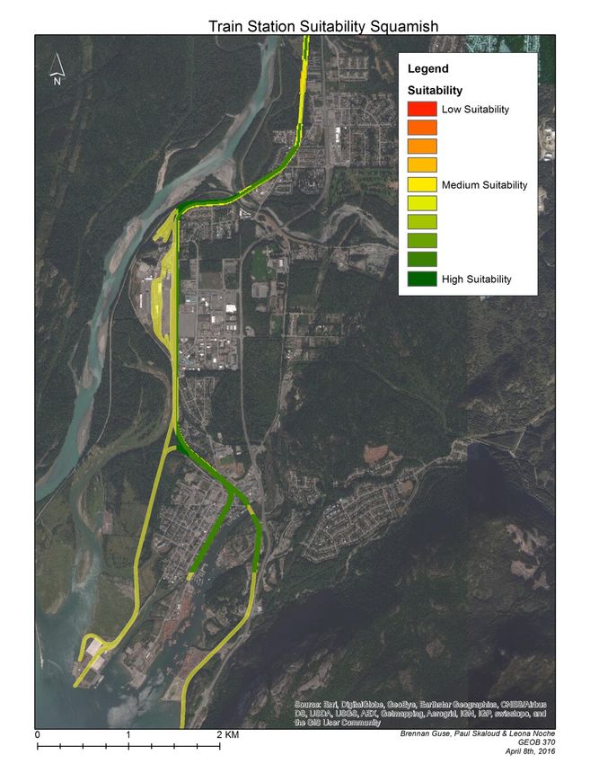
Table of Contents

  Executive Summary…………………………………………………………………………...3

       Research Question……………………………………………………………………..3

       Recommendations……………………………………………………………………...3

       Methods…………………………………………………………………………………3

 Literature Review………………………………………………………………………………4

 BC Rail History…………………………………………………………………………………4

 Review of Communities along the Line……………………………………………………….5

 Demand Analysis……………………………………………………………………………….6

       Case Study- Between Squamish and North Vancouver……………………………..6

             Where are People Travelling in this Region…………………………………7

             Potential Train Passengers for this Region…………………………………..7

       Case Study- Between Squamish and Whistler……………………………………….8

             Where are People Travelling in this Region…………………………………8

             Potential Train Passengers for this Region…………………………………..8

 Type of Service…………………………………………………………………………………9

       When the Trains will Run……………………………………………………………..9

       Type of Trains…………………………………………………………………………10

       Where the Stations should be located………………………………………………..10

 Cost Analysis…………………………………………………………………………………..14

      Cost- Driving Vs Train………………………………………………………………..15

 Benefits of a Train……………………………………………………………………………..15

Final Recommendations……………………………………………………………………….15

                                                                      2
Executive Summary
Research Question
I have been asked by the Engineering and Environmental Services Department of the District of
West Vancouver to provide an overview of the feasibility of a commuter train connecting the Sea
to Sky Corridor to the North Shore in Metro Vancouver, which would link the communities of
Whistler, Squamish, Lions Bay, West Vancouver, and the City and District of North Vancouver.
My main point of contact for this work was John Calimente, Transportation Planning Analyst
with the District of West Vancouver.
Recommendations
1. I recommend implementing a commuter train service that travels between Squamish and
North Vancouver.
2. There should be 3 commuter trains, leaving Squamish at 6:00, 6:30, and 7:00am. The
trains would then leave North Vancouver at 4:00, 4:30 and 5:00pm, Monday to Friday.
3. A price of $25.22 per passenger would cover the capital and operating costs of the train.
However, with taxes, substitutes and investors I would reduce to cost to $15 per person.
4. Single level tilting cars should be put in operation.
5. The main train stations should be located at Downtown Squamish, Horseshoe Bay,
Dundarave, Park Royal, and Lonsdale Quay.
Methods
This report has been conducted through both quantitative and qualitative research methods. First,
a literature review was executed looking at an abundance of transportation reports along the
corridor. An expert interview with Ian Fisher, Manager of Planning and Operations at Sky Train
was completed for a better understanding of the type of service that can be implemented. This
report also looked into a variety of databases including BC Data and the BC Ministry of
Transportation and Infrastructure. Finally, GIS software allowed for the creation of maps and
supplementary analysis to determine possible train station locations.
3Literature Review
An abundance of literature on transportation options along the Sea to Sky corridor was consulted
in the creation of this report. (AECOM 2009, CANAC 2001, District of Squamish 2009,
Seymour 2001, TSi 2002, Washbrook 2003). Many of these reports touched on topics such as
demand, costs, type of service and review of communities along the line. Although these reports
were highly influential for the results of this report, several gaps can be found in the literature.
For example, many of the reports are from the early 2000s, during this period there was a large
demand to look at transportation options along the Sea to Sky corridor in preparation for the
2010 Winter Olympic Games. For the Olympics it was decided to expand Highway 99, however
now that the Olympics have past, there has been little research on transportation options in the
region. I also noticed that many reports didn’t measure demand for a train in response to a range
of fair costs. Often the reports would have a high passenger cost for a train service, and because
of the high cost it would deter ridership. This report tries to bridge the gaps and encourages the
District of West Vancouver to continue discussion on a commuter train service along the Sea to
Sky Corridor.
BC Rail History
BC Rail is owned by CN and is currently the rail line that goes from North Vancouver to Prince
George. The line originated in 1912 and was first called the Pacific Great Eastern Railway (PGE)
(Ramsey, 1962). This line was vital in the growth of the BC economy in the early 20th century as
it connected smaller towns in the north to the Lower Mainland. Over its lifetime it has been used
for passengers, tourism, logging and other shipments (Harris, 1982). Passenger service ended on
October 31, 2002. Currently the line is used for freight and tourism purposes. Freight trains run 2
to 3 times a day at varying schedules, and the Rocky Mountaineer runs daily except Tuesdays
and Wednesdays from May 15th to September 21st.
4Review of Communities along the Line
Figure 1- Review of communities along the line
Location Population in Population Population Current Transit
2011 estimates for 2021 Growth System
Whistler 9,824 12,190 24% -BC Transit
-9 local bus routes
-Greyhound
Squamish 15,051 25,000 66% -BC Transit
-4 local bus routes
-Greyhound
Lions Bay 1,318 1,425 8% -TransLink
- 2 local bus
routes
Bowen Island 3,402 4,300 26% -BC Ferries
-TransLink
-2 local bus routes
West Vancouver 44,000 51,000 16% -BC Ferries
-Blue Bus
-TransLink
-23 local bus
routes
North Vancouver 84,412 98,000 16% -TransLink
-Blue Bus
-26 local bus
routes (including
SeaBus)
Metro Vancouver 2.4 million 2.7 million 12.5% -TransLink
-VIA Rail
-Greyhound
-Rocky
Mountaineer
(BC Transit 2016, Corman 2006, Simply Map, Stats Can 2011, TransLink 2008)
Figure 1 is a review of the communities close to the line in terms of population in 2011,
projected population for 2021, and the current transit systems in the selected locations. A general
trend is the significant increase in population in all of the locations. However, what is most
significant is Squamish’s projected population growth. In 2011, the population was 15,051 and is
projected to reach 25,000 by 2021 (Stats Can). This is a potential growth rate of 66%.
5Squamish’s massive population projections are partly due to major developments that are
planned for the region. For example, Garibaldi at Squamish Ski Resort is projected to create
4000 jobs to operate the resort, have 1,500 hotel rooms, over 2000 residential units and estimates
to bring in 730,000 skiers a year (Findlay, 2016). Another major development is Squamish’s
Oceanfront. This project is planned to have over 1,100 residential units, and will take more than
2,300 jobs to build. The land for this project has already been sold to the developer as of
February 3rd 2016, and is projected to take 20 years to build all 6 phases (Squamish Oceanfront
Development Corporation, 2016).
Demand Analysis
The demand analysis will be split up into two case studies.
Figure 2- Case studies
1.Barb the Business woman:
Barb represents the demographic who
live in Squamish where housing is
relatively affordable, and commutes
to work in Metro-Vancouver.
2.Sam the Skier:
Sam represents the tourist demographic
and those who live in Whistler.
(Photos courtesy of Flickr and Wikipedia)
Case Study- Between Squamish and North Vancouver
Barb the Business woman represents the demographic who live in Squamish where housing is
relatively affordable, and commute to work in Metro Vancouver throughout the week. Like Barb,
many locals in Squamish are young/ educated families. It is estimated that the median age in
Squamish is 36.8 years old (Stats Can, 2011). Since Barb has lived in Squamish for over 10 years
now, she has noticed a dramatic increase in the volume of cars on the highway. It sometimes
takes Barb over an hour to get from Squamish to her office in downtown Vancouver, where she
then has to pay a high cost for parking.
6Where are People Travelling in this Region
- It is estimated that there were 1,865 daily southbound commuters (people) from Squamish in
2012 (Seymour, 2001).
- Over 1,300 Squamish Residents work full time in Whistler (AECOM, 2009).
- Traffic peaks along the Sea to Sky highway, just south of Squamish occur at 7:00 – 8:00 am
and 4:00 – 5:00pm (AECOM, 2009).
Potential Train Passengers for this Region
The BC Ministry of Transportation and Infrastructure collects traffic data from various locations
throughout the province. Using this traffic count data for a site called Eagles Ridge, north of
Horseshoe Bay, estimates can be determined for the amount of train passengers. A base
passenger rate of 25%, a medium passenger rate of 33% and a high passenger rate of 50% have
been chosen for this analysis. For example, if 25% of the vehicles were taken off the road and
put on a train, how many train passengers would there be, assuming there is one person per
vehicle? These conversion percentages were decided on as they are used in another report that
looked at a ferry service from Squamish to North Vancouver (Seymour, 2001).
Figure 3- Potential train service between Squamish and North Vancouver
Date Total Passengers: Base Passengers: Med Passengers:
Southbound 25% 33% High 50%
commuters
(vehicles)
between 6:00 am
and 9:00am
Wednesday, 1,927 482 636 964
st
April 1 2015
Friday, August 1,878 470 620 939
th
14 , 2015
Monday, 2,131 533 703 1,066
January 19th,
2015
Average of the 1,979 495 653 990
sample dates
(BC Ministry of Transportation and Infrastructure, 2015)
For the sample dates, the base ridership is 495 southbound passengers which is equivalent to 990
total passengers a day. Again this is the base ridership, I would suggest a ridership of around 600
people a day, per direction, or a total of 1,200 people a day if you consider Squamish’s projected
population growth.
7Case Study- Between Whistler and Squamish
Sam the Skier represents the tourist demographic and those who live in Whistler. Sam finds
getting from Whistler to Squamish a challenging task. Sam grew up abroad and is not
accustomed to winter driving conditions and finds the highway is often unreliable due to all the
closures. In addition, because Sam works primarily as a ski instructor, buying winter tires for his
car is a relatively large expense.
Where are people travelling
-Whistler receives around 2.1 million visitors each year. (Tourism Whistler, 2016).
- Most visitors travel to Whistler in a private vehicle on Highway 99, while others arrive through
scheduled bus services that run from YVR more than 10 times daily (Tourism Whistler, 2016).
- Over 1,300 Squamish Residents work full time in Whistler (AECOM, 2009).
Potential Train Passengers for this Region
Using the Ministry of Environment’s traffic count data for a site just north of Squamish,
estimates can be determined about the number of commuters from Squamish to Whistler. It is
notable that most commuters in the area are going Northbound to Whistler in the mornings.
Figure 4- Potential train service between Squamish and Whistler
Date Total Passengers: Passengers: Passengers:
Northbound Base 25% Med 33% High 50%
commuters
(Vehicles)
between 6:00am
and 9:00am
Wednesday, 1,040 260 343 520
April 1st, 2015
Friday, August 871 218 287 436
14th, 2015
Monday, 1,369 342 452 685
January 19th,
2015
Average of the 1,093 273 361 547
sample dates
Source: (BC Ministry of Transportation and Infrastructure, 2015)
8Looking at the numbers above, for the sample dates the base ridership is 273 Northbound
passengers, which is equivalent to 546 total passengers a day. I suggest that these numbers are
too low to implement a commuter train service between Squamish and Whistler. I recommend
implementing a commuter train from Squamish to North Vancouver, see how successful that line
is, and then 10 to 20 years in the future relook at the demand analysis for Squamish to Whistler.
It is also important to note that a commuter train varies from all day service, if the District of
West Vancouver was interested in all day service to Whistler, the demand analysis would have to
be altered.
Type of Service
This section will look at when the trains should run, the type of trains, and where the train
stations should be located.
When the Trains will run
In 2008, the District of Squamish sent out a survey to 634 residents asking them what times they
would want a potential commuter train to leave Squamish and the lower Mainland. According to
the results, the best times to have a commuter train leave Squamish would be 6:00, 6:30, and
7:00am and the best times to leave North Vancouver would be 4:00, 4:30 and 5:00pm.
Figure 5- Survey of when the trains will run
(AECOM, 2009)
9Type of Trains
Ian Fisher, Manager of Planning and Operations for Sky Train indicated that each train car can
hold 80 to 100 people. A train car is one unit of a train, where all the cars put together make up
the entire train. He also told me that each car is approximately 25 meters long by 3 meters wide.
I suggest there be 3 trains consisting of 3 cars each. Considering the demand numbers of
approximately 600 people per day, per direction, then divide that by 3 trains you get roughly 200
people per train. Technically 200 people can fit into 2 train cars, but then the train would be at
maximum capacity. By adding an extra car, it allows the train to respond to future service
demands. The Canada Line, for example did not consider future ridership demand as much as it
should have when it was built in Vancouver in preparation for the 2010 Olympics. Right now in
2016, the Canada Line is already at maximum capacity, and it would be very costly to increase
the size of the prebuild station platforms to service an extra car on each train. Therefore, a
potential train service from Squamish to North Vancouver should have platforms of at least 75
meters long at each train station. This way 3 train cars can fit on the stations, and the line will be
well suited for future demand.
Ian also suggested that single level tilting cars would be the best type of train for the Sea to Sky
corridor. Tilting cars can reduce travel time by 10% to 15%, create a smoother ride resulting in
less motion sickness, and can be implemented in a wide variety of options such as diesel or
electric. The bullets below show the run time of trains versus a passenger car from Squamish to
North Vancouver. A Bud Rail Diesel car is the type of passenger train that used to run along the
corridor, until the service ended in 2002.
• Bud Rail Diesel: 80 minutes
• Tilting Cars: 68 minutes
• Passenger Car: 55 minutes
The information above is retrieved from Ian Fisher and an extract from the 1998 BC Rail
timetable.
I would recommend implementing single level titling cars, however depending on the budget,
technology advances and other factors, more discussion should be made about the type of train
that would run along the corridor.
Where Should the Train Stations Be Located
Using Geographic Information System (GIS) software, I was able to determine the best areas for
train station locations. In order to do this, I had to collect data from various sources such as
Geogratis, Abacus, BC Data, the City of North Vancouver, and the District of North Vancouver,
West Vancouver and Squamish. I then performed a multi-criteria analysis to determine the best
suitability for train station locations. A multi-criteria analysis basically entails weighing different
factors that would affect the train station suitability. All of the factors combined must be equal to
one. The factors considered in the analysis are shown in the chart below.
10Figure 6- Train station weighting system
Criteria Factors Weighting
Zoning Where can a station be 0.5
built? (Ex: residential
land= low values, public
land= high values)
Bus Routes Are the stations close to 0.2
bus routes? (Within
500m)
Population Are there enough people 0.2
in the region to support a
station? (Over 50 people
and jobs per hectare)
Slope Is the slope of the land 0.1
suitable for a station?
(Less than 45 degrees)
If necessary, the weighting and criteria can be altered for the specific needs of the District of
West Vancouver and other municipalities.
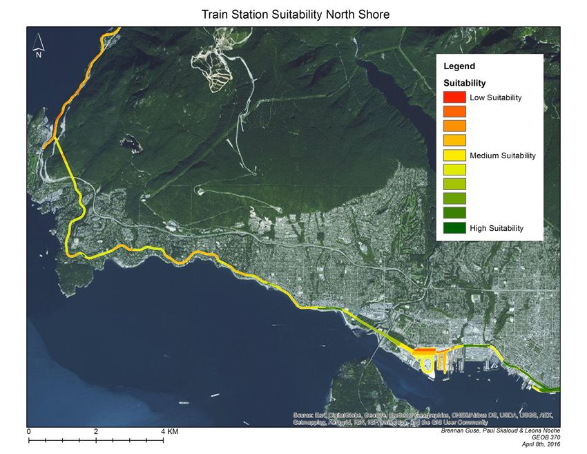
The images below represent the suitability for train station locations from Squamish to North
Vancouver. The areas in red represent the lowest suitability, the areas in yellow represent a
medium suitability, and the areas in green represent a high suitability for a station. From this
analysis it can be observed that the main train stations should be located at: Downtown
Squamish, Dundarave, Park Royal, and Lonsdale Quay. Although Horseshoe Bay does not
appear in green on the map, I would recommend adding it as a stop since it experiences heavy
ferry traffic. In addition, the last stop should be Lonsdale Quay as it has a Sea Bus service that
goes directly to downtown Vancouver. I would also recommend adding smaller stops in
locations such as Lions Bay, Furry Creek and Porteau Cove.
11Figure 7
12Figure 8
13Further research would have to be done on what real estate is available for purchase in the areas
that are shown in green on the map. When considering what real estate is available, a lot size of
75meters by 30 meters would be ideal for a train station. The report, The Transportation Hub, by
the District of Squamish has selected exact locations where train stations are most suitable.
Cost Analysis
The data below is from Patrick Condon, a University of British Columbia Professor in the faculty
of Landscape Architecture.
Figure 9
Average Capital and Operating Costs Per Passenger Mile
Mode Capital Costs Operating Costs
Diesel Bus $0.31 $1.19
Light Rail $1.27 $.039
Heavy Rail $0.24 $0.36
Commuter Rail $0.26 $0.39
Sky Train $2.34 $0.29
Ford Explorer $1.02 $0.18
Modern Tram $0.71 $0.51
Source: (Condon and Dow 2009, The Antiplanner 2007)
The number above are based on maximum capacity. If the modes listed above were not at
maximum capacity, the costs would be much higher. Capital costs include acquiring the vehicles
and constructing the infrastructure necessary to support them. Capital costs would be much lower
along the Sea to Sky corridor since a rail line is already in place.
It is approximately 62.4 kilometres from the Sea Bus terminal in North Vancouver to Squamish.
Therefore, a price of $25.22 per person would apply to cover capital and operating costs for a
commuter train to break even.
Transportation services run by the public sector traditionally do not expect to recover their full
operating and capital costs from customer fares. For example, the West Coast Express is
considered successful by governments even though it recovers only 60% of its costs through
passenger fares (Washbrook, 2003). I recommend implementing a price around $15 per
passenger, therefore additional funding would have to be provided though taxes, subsidies, and
investors.
14Cost Analysis- Driving Vs Train
How much does Barb spend on gas and parking during a day in the office?
Hourly rates at Vancouver’s downtown meters and parkades range from $1 to $7 per hour
(Aiello, Laanela and Smith 2014). Barb drives a Mazda 3, assuming gas prices in Vancouver are
$1.30 a liter, it costs her $7.80 to go 100km on the highway. Barb drives 123km a day to and
from work, therefore Barb spends around $35.00 a day on gas and parking, assuming her parking
is $3.00/hour and she works 8 hours a day. If the train was $15.00 one way, or a total of $30 for
both directions, Barb would save $5 a day. This is a total savings of over $1000 a year. Lets also
remember that this does not take into account the actual price of a car and insurance, which is
likely to be over $4000 a year.
Benefits of a Train
This section will discuss some of the benefits of a train (Condon, 2010).
• Economic: new business, attracts more events, growth, new investment, enhances the
downtown core, more tourists.
• Social: promotes sustainability, active lifestyle, freedom (can get work done on a train),
safety, spectacular views, comfort.
• Environmental: cars off the road, enhances the transit network, less demand to widen the
highway, less emissions.
Final Recommendations
1. I recommend implementing a commuter train service that travels between Squamish and
North Vancouver.
2. There should be 3 commuter trains, leaving Squamish at 6:00, 6:30, and 7:00am. The
trains would then leave North Vancouver at 4:00, 4:30 and 5:00pm, Monday to Friday.
3. A price of $25.22 per passenger would cover capital and operating costs, however with
taxes, substitutes and investors I would reduce to cost to $15 per person per commute.
4. Single level tilting cars should be put in operation.
5. The main train stations should be located at Downtown Squamish, Horseshoe Bay,
Dundarave, Park Royal, and Lonsdale Quay.
15Bibliography
AECOM Canada. (2009, October 8). Transportation options for the Squamish-Metro Vancouver Corridor. Retrieved
February 20, 2016, from http://squamish.ca/assets/PDF/3.11-TransportationStudyAECOM.pdf
Aiello, R., Laanela, M., & Smith, K. (2014). Vancouver Downtown parking costs | CBC B.C. Retrieved April 08,
2016, from http://www.cbc.ca/bc/interactive/maps/parking-costs/
BC Ministry of Transportation and Infrastructure. (2015). Traffic Data Program. Retrieved February 19, 2016, from
http://www.th.gov.bc.ca/trafficData/tradas/tradas.asp?loc=P-99-01NS
BC Transit. (2016). Bus Schedules. Retrieved February 24, 2016, from http://bctransit.com/squamish/home
CANAC Inc. Higher Speed Passenger Rail Vancouver to Whistler. Rep. 2001. Print.
Condon, Patrick M., Professor, and Kari Dow. A Cost Comparison of Transportation Modes. Rep. no. No.7. 2009.
Print.
Condon, Patrick M. Seven Rules for Sustainable Communities: Design Strategies for the Post-carbon World.
Washington: Island, 2010. Print.
Corman, M. (2006, November). Bowen Island MCA. Retrieved February 22, 2016, from
http://www.sfu.ca/geog/geog355fall06/mdc1/introduction.html
District of Squamish. The Transportation Hub. Rep. 31 Mar. 2009. Web. 30 Jan. 2016
Findlay, A. (2016, January 29). B.C. approves a multi-billion dollar ski resort that the industry doesn't want.
Retrieved April 01, 2016, from http://www.bcbusiness.ca/tourism-culture/bc-approves-a-multi-billion-dollar-ski-
resort-that-the-industry-doesnt-want
Harris, Lorraine. British Columbia's Own Railroad. Surrey, B.C., Canada: Hancock House, 1982. Print.
Metro Vancouver. (2015). Appendix A. Retrieved February 22, 2016, from
http://www.metrovancouver.org/services/regional-planning/PlanningPublications/TableA1-
PopDwelUnitEmpProjforMVSubregMuni.pdf
Ramsey, Bruce. PGE, Railway to the North. Vancouver: Mitchell, 1962. Print.
Seymour, J. (2001, December 21). Marine Options Greater Vancouver to Squamish (Rep.). Retrieved February 24,
2016, from BC Ministry of Transportation website.
Squamish Oceanfront Development Corporation. (2016). Retrieved April 01, 2016, from
http://www.squamishoceanfront.com/plan
Statistics Canada. 2011 Stats Can Data on Squamish Commuters. 2011. Raw data. British Columbia, Squamish
The Antiplanner. (2007, March 20). Retrieved February 28, 2016, from http://ti.org/antiplanner/?p=88
Tourism Whistler Trade and Travel Website. (2016). Retrieved February 20, 2016, from
16http://trade.whistler.com/about/stats/
Translink. Transport 2040. Rep. 2008. Web. 24 Jan. 2016.
TSI Consultants. Sea-to-Sky Corridor Travel Demand Study. Rep. Jan. 2002. Web. 30 Jan. 2016.
Washbrook, Kevin. Developing a Sustainable Transportation Strategy for the Sea to Sky Corridor: How Have
Supply Options Been Evaluated. Rep. June 2003. Web. 30 Jan. 2016.
17You can also read