CONCEPTUAL FRAMEWORK FOR MARINE SPATIAL PLANNING IN THE MEDITERRANEAN - PAP/RAC
←
→
Page content transcription
If your browser does not render page correctly, please read the page content below

CONCEPTUAL FRAMEWORK FOR MARINE SPATIAL PLANNING IN THE MEDITERRANEAN
CONCEPTUAL FRAMEWORK FOR MARINE SPATIAL PLANNING IN THE MEDITERRANEAN

CONCEPTUAL
FRAMEWORK FOR
       SPATIAL
PLANNING IN THE
MEDITERRANEAN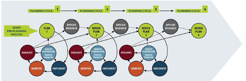
CONCEPTUAL FRAMEWORK FOR MARINE SPATIAL PLANNING IN THE MEDITERRANEAN

LEGAL NOTICE
The designations employed and the presentation of the material in this document do not imply the expression of any opinion what-
soever on the part of UN Environment/MAP concerning the legal status of any State, Territory, city or area, or of its authorities, or
concerning the delimitation of their frontiers or boundaries.

COPYRIGHT
This publication may be reproduced in whole or in part and in any form for educational or non-profit purposes without special permis-
sion from the copyright holder, provided acknowledgement of the source is made. UN Environment/MAP would appreciate receiving a
copy of any publication that uses this publication as a source. This publication cannot be used for resale or for any other commercial
purpose whatsoever without permission in writing from UN Environment/MAP.

© 2018 United Nations Environment Programme / Mediterranean Action Plan (UN Environment/MAP)
P.O. Box 18019, Athens, Greece

For bibliographic purposes this volume may be cited as:
Conceptual Framework for Marine Spatial Planning in the Mediterranean UN Environment/MAP Athens, Greece (2018).

Graphic layout and production
Strategic Agenda. London

Cover photo
Pok Rie, Pexels.com

UN Environment/MAP – United Nations Environment Programme – Mediterranean Action Plan
Secretariat to the Barcelona Convention
48, Vassileos Konstantinou Avenue 11635
P.O Box: 18019, Athens Greece
Tel: +302107273100 Fax: +30 2107253196
www.unepmap.org

                        The views expressed in this publication
                        do not necessarily reflect the views of the
                        European Commission.
CONCEPTUAL FRAMEWORK FOR MARINE SPATIAL PLANNING IN THE MEDITERRANEAN

ACRONYMS

BD		      Biodiversity
CAMP		    Coastal Area Management Programme
CF		      Conceptual Framework for MSP
COP		     Conference od Parties
CP(s)		   Contracting Party (-ies)
EcAp		    Ecosystem Approach
EIA		     Environmental Impact Assessment
EU		      European Union
EUSAIR    European Union Strategy for the Adriatic and Ionian Region
FAO       Food and Agriculture Organisation
GES 		    Good Environmental Status
ICZM      Integrated Coastal Zone Management
IMAP		    Integrated Monitoring and Assessment Programme
IOC       Intergovernmental Oceanographic Commission
LSI		     Land Sea Interactions
MAP       Mediterranean Action Plan
MSFD      Marine Strategy Framework Directive
MSP		     Marine Spatial Planning or Maritime Spatial Planning
MTS		     Mid-Term Strategy
PoW 		    Programme of Work
SEA		     Strategic Environmental Assessment
SPA		     Specially Protected Areas
UNEP		    United Nations Environment Programme
UNESCO    United Nations Educational, Scientific, and Cultural Organisation

1        CONCEPTUAL FRAMEWORK FOR MARINE SPATIAL PLANNING IN THE MEDITERRANEAN

    1. INTRODUCTION
    As reported in the UNEP/MAP Mid-Term Strategy 2016-2021                                   The geographic scope of the Protocol includes both the land
    (MTS), the Contracting Parties, at COP 18 recommended to                                  and the sea and it follows that planning should be equally
    strengthen MAP activities in the field of Marine Spatial Planning                         applied to both components of the coastal zones. While MSP is
    (MSP)1 in order to contribute to GES, investigate in more details                         a relatively new term within the Barcelona Convention frame, it
    connections between land and sea areas and propose coherent                               is clear that planning of the marine space is a concept already
    and sustainable land and sea-use planning frameworks relating                             taken on board by the Protocol. In this perspective MSP can be
    with key economic sectors and activities that may affect the                              considered the main tool/process for the implementation of
    coastal and marine resources. The elaboration of a Conceptual                             ICZM in the marine part of the coastal zone and specifically for
    Framework (CF) for MSP as an emerging issue in the entire                                 its sustainable planning and management. Art. 3 of the ICZM
    Mediterranean Region is envisaged by the UNEP/MAP PoW                                     Protocol also defines the geographic scope of the operational
    approved for 2016-2017, with the main aim of introducing MSP                              application of MSP that shall focus on the marine area following
    within the Barcelona Convention.                                                          within the territorial sea of a country. Requirement to take land-
                                                                                              sea interactions into account is specified in Art. 6.
    Although MSP is not expressly mentioned in the Protocol on
    ICZM in the Mediterranean, spatial planning of the coastal zone                           Also, MSP is considered as one of the tools to implement the
    is considered an essential instrument of the implementation                               EcAp as a strategic approach towards sustainable development
    of the same Protocol. One of the main objectives of ICZM is                               in the region that integrates all of its three components, i.e.
    to “facilitate, through the rational planning of activities, the                          environmental, social and economic. MSP should guarantee
    sustainable development of coastal zones by ensuring that the                             that they are in balance.
    environment and landscapes are taken into account in harmony
    with economic, social and cultural development” (art. 5). Planning                        Given the definition of the coastal zones in the ICZM Protocol,
    is recalled also in other articles of the Protocol, as in the case                        almost all other Protocols of the Barcelona Convention are
    articles dealing with the protection of wetlands, estuaries and                           related in one or the other way to it. ICZM can and should provide
    marine habitats (art. 10) or the protection of coastal landscape                          support to the implementation of several of these Protocols,
    (art. 11).                                                                                and the relevant objectives and provisions of these Protocols
                                                                                              should be taken into account in all ICZM projects, plans and
    According to art. 3 the area to which the Protocol applies (i.e.                          strategies. Given these links, the application of MSP within the
    the coastal zones) is the area between:                                                   framework and the geographic scope of the ICZM Protocol can
                                                                                              contribute to the goals defined by other protocols, as in the
    •   the seaward limit of the coastal zone, which shall be the                             case of identification, planning and management of protected
        external limit of the territorial sea of Parties; and                                 areas according to the SPA/BD Protocol or the protection of the
                                                                                              Mediterranean Sea against pollution resulting from exploration
    •   the landward limit of the coastal zone, which shall be the                            and exploitation of the continental shelf and the seabed and its
        limit of the competent coastal units as defined by the                                subsoil (so called Offshore Protocol).
        Parties.

    1        In this document, Marine Spatial Planning and Maritime Spatial Planning are used interchangeably. In fact, there is no different meaning of the two concepts.
             Marine Spatial Planning is used all around the world, while Maritime Spatial Planning is the term mainly used within the EU and for the relevant Directive, in
             particular. Both concepts deal with the sustainable management of marine ecosystems and maritime human activities and related socio-economic benefits.
CONCEPTUAL FRAMEWORK FOR MARINE SPATIAL PLANNING IN THE MEDITERRANEAN 2
2. OBJECTIVES OF THE CONCEPTUAL FRAMEWORK
The Conceptual Framework on MSP has two main objectives:
• To introduce MSP in the framework of the Barcelona
Convention, and in particular link it to ICZM, considering MSP
as the main tool/process for the implementation of ICZM
in the marine part of the coastal zone and specifically for
planning and managing maritime human activities according
to EcAp goals (as specifically addressed by section 3 of the
CF).
• To provide a common context to CPs for the implementation
of MSP in the Mediterranean Region.
The CF is intended to be a short and easy-to-use document, a
sort of guiding reference for the implementation of MSP, based on
common principles, contents and steps. Several customized step-
by-step methodologies have been developed (e.g. by PlanCoast,
SHAPE, ADRIPLAN, THAL-CHOR projects), used together with
technical tools in pilot cases to test them in Mediterranean
conditions (e.g. “Paving the road to MSP in the Mediterranean”)
and are available for MSP implementation in the Mediterranean.
Other on-going projects (e.g. SUPREME and SIMWESTMED) will
provide further methodological input. Moreover, the UNESCO-IOC
guidebook on MSP represents an overarching inspiring document
and the European wide MSP Platform provides a rich catalogue of
MSP practices. The challenge is to capitalize available experiences
rather than develop new step-by-step methodologies.
Contents of the CF have been developed building also on
experience from the above-mentioned projects. They can be used
as a checklist to verify that needed elements of the MSP process
are taken in consideration, referring to above mentioned and other
methodologies for specific details. However, in no case such
guidelines shall be considered prescriptive, as each MSP process
needs to be tailored according to specific characteristics of its
geographic scope, objectives and expected results.3 CONCEPTUAL FRAMEWORK FOR MARINE SPATIAL PLANNING IN THE MEDITERRANEAN
3. ECAP AS A GUIDING PRINCIPLE FOR MSP
The Ecosystem Approach (EcAp) is the guiding principle to MAP Even the Directive 2014/89/EU establishing a framework for
Mid-term Strategy and the biennium Programme of Work and all MSP clearly recall the importance of applying the requirement
policy implementation and development undertaken under the of the ecosystem based approach, both in the preamble and
auspices of UNEP/MAP Barcelona Convention, with the ultimate under the article provisions; i.e. art. 5 “When establishing and
objective of achieving the Good Environmental Status (GES) of implementing maritime spatial planning, Member States shall
the Mediterranean Sea and Coast. This also applies to the ICZM consider economic, social and environmental aspects to
Protocol and the related planning of land and sea based marine support sustainable development and growth in the maritime
activities, therefore including MSP implementation. sector, applying an ecosystem-based approach, and to promote
the coexistence of relevant activities and uses.”
EcAp can be defined as the integrated management of land,
water and living resources that provides sustainable delivery
of ecosystem services in an equitable way. It goes beyond
examining single issues, species, or ecosystem functions in
isolation. Instead, it recognizes ecological systems for what
they are: rich mixes of elements that interact with each other
continuously. This is particularly important for coasts and
seas, where the nature of water keeps systems and functions
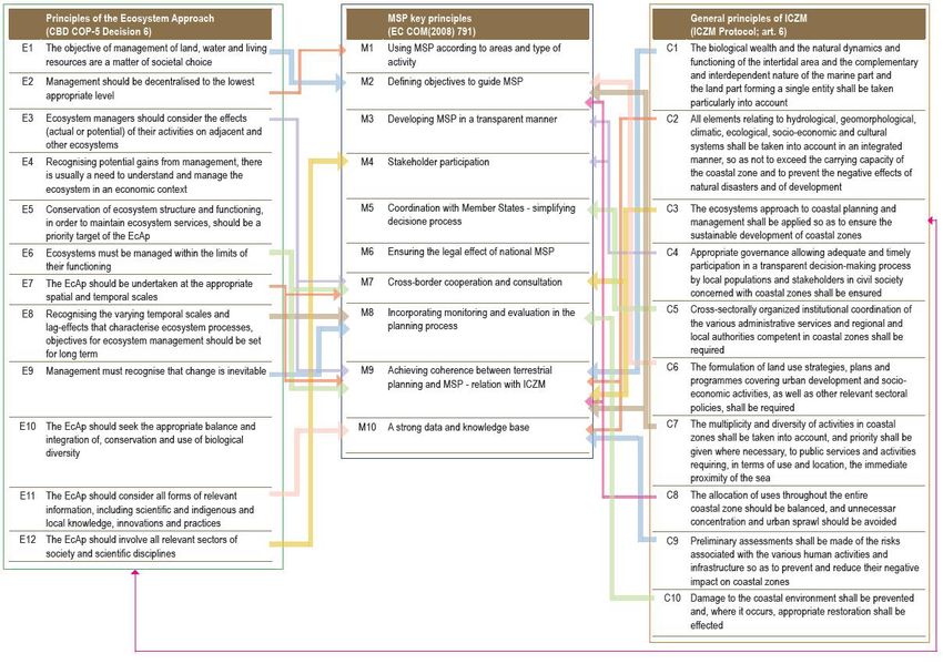
highly connected. Indeed, links between EcAp, MSP and ICZM
principles are wide and articulated
(Figure 1).
Figure 1 – Link between EcAp, MSP and ICZM principlesCONCEPTUAL FRAMEWORK FOR MARINE SPATIAL PLANNING IN THE MEDITERRANEAN 4
Some guidelines can be suggested to apply EcAp within the Indeed, the relationship between EcAp and MSP is a two-way
MSP process, including the following ones: relation, as the second can contribute to the overall objective
of achieving the GES, also through the identification of related
Establish clear links between MSP objectives and ecological spatial measures. Proper planning of maritime activity can:
objectives, targets and indictors defined within EcAp.
• Reduce marine-based source of pressure affecting the
• As far as possible, define the planning and management marine environment through spatial efficiency and control
area considering the limits of ecosystem functioning. of temporal distribution of human activities;
• EcAp does not stop at sea, it involves land too. Taking EcAp • Reduce conflicts between maritime uses and protection of
in consideration in the MSP process also implies a strong areas with high naturalistic and ecological relevance;
focus on land-sea interactions (LSI) and in particular on
interactions among terrestrial and marine ecosystems, • Identify areas to be protected in order to preserve processes
habitats and species. and functions that are essential in achieving the GES;
• Establish MSP (allocation of maritime activities) on best • Identify environmental hotspot areas at sea where more
available scientific knowledge about the ecosystem and its intense measures are necessary;
dynamics, and assess major information gaps and related
uncertainties. • Avoid unsustainable uses in protected areas and identify
synergies that can provide win-to-win solutions for socio-
• Identify the ecosystem services provided by the considered economic development and environmental protection;
marine area and how they underpin human maritime
activities and human well-being in general. • Identify connecting elements among relevant habitats
through blue corridors.
• Evaluate various effects of human activities on the
ecosystem, as: direct and indirect, cumulative, short and
long-term, permanent and temporary, positive and negative
effects, also taking land-sea interaction in consideration.
• Include in MSP the evaluation of cumulative impacts on
the sea that may results from the combination of different
(current and future) maritime and land-based activities.
• Capitalize and tailor existing methods and tools to
operationalize the EcAp concepts within MSP, as:
guidelines for implementation of EcAp, indicators, checklist,
vulnerability assessment, evaluation of cumulative
impacts, ecosystem service mapping and quantification,
identification of blue corridors, EcAp based monitoring and
evaluation program, etc.5 CONCEPTUAL FRAMEWORK FOR MARINE SPATIAL PLANNING IN THE MEDITERRANEAN
4. COMMON PRINCIPLES AND CONTENTS
Available methodologies and scientific literature propose a wide Independently on the considered definition and the specific
range of MSP definitions. Ehler and Douvere (2009)2 includes objectives and expected benefits, a number of common
one of the most quoted one, according to which MSP can be principles and general contents for the implementation of MSP
defined as “a practical way to create and establish a more rational are identified below (some of them totally or partially overlapping
organization of the use of marine space and the interactions with ICZM ones). When dealing with MSP implementation this
between its uses, to balance demands for development with list should be reviewed and tailored according to the specific
the need to protect marine ecosystems, and to achieve social scope and goals of the MSP process and the characteristics of
and economic objectives in an open and planned way”. Another its area of application.
definition very often taken on board is the one given by art. 3
of Directive 2014/89/EU establishing a framework for MSP:
“a process by which the relevant Member State’s authorities
analyse and organise human activities in marine areas to
achieve ecological, economic and social objectives”. Expected
benefits of MSP are:
• Increased horizontal and vertical coordination between
administrations and among different sectors using a single
process (MSP) to balance the development of a range of
maritime activities;
• Reduction of conflicts and exploitation of synergies among
different uses of the marine space;
• Contribution to the equitable access to marine resources;
• Increased stakeholder involvement, public participation
and information sharing;
• Encouragement of investment, by instilling predictability,
transparency and clearer rules;
• Improved protection of the environment, through early
identification and reduction of impacts as well as promotion
of opportunities for multiple use of the same marine space;
• Identification of (spatial) measures that can support the
achievement of the Good Environmental Status (see
section 3);
• Improve protection of cultural heritage and preservation of
intangible values of the sea.
2 Ehler C., and F. Douvere, 2009. Marine Spatial Planning: a step-by-step approach towards ecosystem-based management. IOC Manual and
Guide n. 53, ICAM Dossier n. 6, Paris, UNESCO.CONCEPTUAL FRAMEWORK FOR MARINE SPATIAL PLANNING IN THE MEDITERRANEAN 6
4.1 ADAPTIVE APPROACH 4.2 MULTI-SCALE APPROACH
The adaptive approach is an interactive and systematic process The operational application of MSP within the frame of the
for continually improving policies, plans and management Barcelona Convention shall focus on the marine area following
practices by learning from the outcome of previous steps and within the territorial sea of a country, according to the geographic
cycles. Through this approach policies, plans and programmes scope of the Protocol on ICZM in the Mediterranean
are identified on the basis of the best available knowledge, (art. 3). This operational application can be embedded into
and are then implemented, monitored, periodically evaluated a multi-scale approach, combining top-down and bottom-up
and improved based on evaluation results. This approach perspectives. The multi-scale approach includes the following
is particularly useful in dealing with complex, dynamic and different scales:
uncertain issues, including planning of current and future
uses of the sea. Indeed, MSP does not lead to a one-time plan; • Mediterranean scale addressing the whole sea basin
it is a continuing iterative process that adapts over time. The through cooperation among CPs in the frame of the
following guidelines can be suggested to shape MSP according Barcelona Convention to approach the strategic level of
to an adaptive approach: MSP, as for example: (i) definition of elements for a common
vision and related objectives, (ii) identification of priority
• Design the MSP process including monitoring, evaluation areas and issues to be approached at a transboundary
and revision steps since its beginning; level, (iii) identification of initiatives (e.g. projects) to
address transboundary areas and issues;
• Possibly, promote active adaptive management, which
includes the evaluation and comparison of alternative • Sub-regional scale – where relevant and possible –
hypothesis (e.g. scenarios) about the future evolution of approaching transboundary MSP issues (elements for
the considered marine area; a common vision, objectives, priorities and initiatives) in
sub-Mediterranean regions, also linking to sub-regional
• Develop MSP indicators linked to clear objectives and strategies and plans (e.g. EUSAIR and the West Med
targets, including: governance or process, socio-economic maritime initiative) for coordinated implementation;
and ecological-environmental indicators;
• National scale, fully implementing the MSP process –
• Adopt a medium/long-term perspective to properly deal according to common principles and coherently with the
with the strategic and anticipatory nature of MSP and allow Mediterranean and sub-regional approaches – in marine
to plan, implement, adapt and plan again action over a areas falling within national jurisdiction, with particular
period long enough to get concrete results. reference to the territorial sea according to the geographic
scope of the ICZM Protocol;
Figure 2 – The iterative MSP cycle (source: Ehler and Douvere, 2009)3
3 GESAMP – Joint Group of Experts on the Scientific Aspects of Environmental Protection, 1996. The contributions of sciences to integrated
coastal zone management. Report and studies n. 61. Rome: Food and Agriculture Organisation (FAO) of the United Nations.7 CONCEPTUAL FRAMEWORK FOR MARINE SPATIAL PLANNING IN THE MEDITERRANEAN
• Sub-national and local scales, fostering MSP applications • Interactions related to land-sea natural processes.
aiming to provide evidence of concrete and visible Implication of such processes on coastal management
environmental, social and economic benefits of MSP. Pilot and planning of alternatives for land and marine activities
activities at the sub-national and/or local scale could focus have to be identified and assessed, considering their
on priority areas, such as: highly vulnerable areas, areas dynamic nature. At the same time, human activities can
with major conflicts among uses, areas with high potential interfere with natural processes, impacting on the coastal
for synergies among uses and multi-use opportunities. and marine environment. The analysis of expected impacts
Pilot activities could be also useful to develop and test of land and marine activities – within the SEA framework –
new overarching or item-specific methodologies, including should include the evaluation of their effects on LSI natural
through next generation of CAMP projects better integrating processes and the potential consequent impacts on natural
marine areas through MSP. resources and ecosystem services.
4.3 INTEGRATION • Interactions among land and sea uses and activities.
Almost all maritime uses need support installations
Integration is an essential feature of MSP; it can assume on land, while several uses existing mostly on the land
different meanings: part expand their activities to the sea as well. These
interactions have to be identified and mapped, assessing
• MSP is not only dealing with blue economy. Environmental, their cumulative impacts, benefits and potential conflicts
social, economic and governance aspects have to be all and synergies. Interactions between land and sea activities
taken into consideration to pursue sustainability goals; can extend further beyond the coastal zones, for example
in terms of long-distance connections related to transport
• Integration among sectors is needed to go beyond sector and energy distribution or fish migration up-stream and
policies, plans and regulations; stemming need for blue corridors. Although the primary
focus is on costs, identification and mapping of those
• Vertical and horizontal cooperation among administrations wider connections and assessment of their environmental,
and technical agencies is required to proceed towards social and economic implications is also important. It is
coordination and integration of sector policies and plans; important to note that the Art.9 of the Protocol requires that
CPs shall accord specific attention to economic activities
• Integration between land-based and marine planning is that require immediate proximity to the sea. This is also
essential to harmonize and ensure coherence among one of the general principles of ICZM (Art.6 para g).
parts of the same coastal system, interacting each other in
different ways. • Interactions of planning processes and plans for land and
sea areas. It is important to ensure that legal, administrative,
4.4 LAND-SEA INTERACTIONS consultation and technical processes are coordinated
(and hopefully linked) to avoid unnecessary duplications,
Understanding and addressing land-sea interactions (LSI) is incoherence, conflicts, waste of resources and/or excessive
crucial to ensure sustainable management and development demand of stakeholders’ efforts. The challenge is to plan
of coastal areas and coherent planning of land and sea-based and manage inshore and offshore activities in harmonized
activities. Although there is not a single and recognized definition manner considering the functional integrity of the land-
of LSI, land-sea interactions can be defined as “interactions in sea continuum. This also implies allocation of land space
which land-based natural phenomena or human activities have (and related infrastructure and services) to some maritime
an influence or an impact on the marine environment, resources activities (and/or the allocation of maritime space to
and activities and vice versa interactions in which marine some land-based activities. Finally, the achievement of
natural phenomena or human activities have an influence or an this coherence also requires alignment/integration of the
impact on the terrestrial environment, resources and activities”. different approaches, methodologies and tools applied
As a consequence of the above definition, three main levels of respectively on land and at sea.
LSI should be taken on board when dealing with MSP:CONCEPTUAL FRAMEWORK FOR MARINE SPATIAL PLANNING IN THE MEDITERRANEAN 8
4.5 FOUR DIMENSION OF MSP 4.7 SUITABILITY AND SPTIAL EFFICIENCY
MSP operates in three spatial dimensions, taking in Suitability of maritime activities and spatial efficiency in
consideration maritime uses and related conflicts operating distributing these activities are key guiding concepts for MSP,
on the: ocean surface, water column and seabed. Time can aiming at improving the sustainability of the use of marine
be taken into account as a fourth dimension. In terms of MSP resources (including the marine space), minimize conflicts
implementation, this may imply: among uses (including nature protection) and exploit possible
synergies. To this regard the following guidelines are suggested:
• For each maritime use identification of the most relevant
spatial dimensions and assessment of the compatibility • Use the sea space for those uses which really depend on
with other uses that mainly occur in other dimensions (e.g. marine resources or that can be more efficiently operated
shipping and sand extraction from the sea-bed); at sea (i.e. it is worth transferring a land-based use to the
sea if this generates higher benefits and lower impacts and
• Synergies and compatibilities among different uses can conflicts);
also be enabled through temporal zoning and regulation,
as for example enabling access to military restricted areas • When dealing with planning, start identifying immovable
to shipping or recreational activities, if there are not military and not-renounceable uses and functions that normally
operations and safety is ensured; have priority in space allocation;
• Proper assessment of the 4 dynamic needs of each • Encourage co-use or multi-use of the same marine area as
maritime use to evaluate whether compatibilities are really much as possible, provided that this implies higher benefits,
possible and conflicts are minimized. lower impacts and reduced conflicts;
4.6 KNOWLEDGE BASED PROJECT • Spatial efficiency should also imply a fair distribution of
MSP-related socio-economic benefits in the whole planned
MSP must rely on high-quality data, focusing on key relevant marine area.
information, as also stressed by EcAp and the adaptive
management approach. To this regard the following guidelines 4.8 CONNECTIVITY
are suggested:
MSP does not only focus on proper and efficient spatial
• Use best available knowledge to promote the definition allocation of maritime uses, but also deals with connectivity.
of the most appropriate geographic scale and scope for Improved connections aim to generate social, economic,
MSP strategies and/or plans, also taking EcAp/IMAP into environmental and governance benefits; the following guidelines
consideration (i.e. ecosystem limits) and considering LSI are suggested:
an essential element of MSP;
• Consider in the MSP plan connections between linear
• Focus on the collection of data and information which are elements as for example shipping lanes to develop an
really essential for MSP; integrated maritime transport system, energy grid to
improve energy distribution efficiency or blue corridors to
• Identify the specific gaps that might hamper the MSP and connect natural habitats;
that require specific actions;
• Consider in the MSP plan connections of patches, areas
• Take in consideration any form of “good quality” with similar or interrelated uses or functions as in the case
knowledge. This comes primarily from scientific sources of networking of marine protected areas or the preservation
and institutionalized monitoring activities and datasets, of connected habitats which are vital for marine species;
but should also capitalize private sources of information,
including knowledge generated by people living and • Beyond planning of maritime uses, do not forget to create
working at the sea; connections among MSP operators in terms of knowledge
sharing, cooperation and coordination.
• Improve transparent access to accurate and complete
information; Assessment and planning of connectivity elements is
particularly relevant for LSI aspects.
• Go from data and knowledge to information really useful
for the planning and decision-making process required
by MSP. Spatial-based tools are particularly useful to this
regard.9 CONCEPTUAL FRAMEWORK FOR MARINE SPATIAL PLANNING IN THE MEDITERRANEAN
4.9 CROSS-BORDER COOPERATION
Although MSP can be seen primarily as a country-based process,
cross-border cooperation is essential to ensure the MSP plans
are coherent and coordinated across the coastal zones and the
marine regions. This implies cooperation at the methodological
(common methods, data and information sharing, tools sharing,
MSP practice exchange, capacity building), strategic (common
vision, shared principles and possible common objectives) and
implementation (e.g. planning of marine bordering areas, etc.)
levels.
Moreover, it is well-known that a relevant number of problems
and challenges (e.g. maritime transport operation and safety, fish
stock conservation and sustainable management, biodiversity
protection and ecosystem preservation, future development of
off-shore renewable energy production and distribution, etc.) have
a transboundary dimension and might require the adoption of a
common regional or sub-regional approach.CONCEPTUAL FRAMEWORK FOR MARINE SPATIAL PLANNING IN THE MEDITERRANEAN 10
5. MSP STEPS
MSP has several definitions. The variety of definitions is reflected • Linking the strategic vision to the sustainable development
by the variety of available methodologies; i.e. there is not a of marine areas and the sustainable use of marine
single approach fitting to all marine contexts and responding resources. The overall aim is ensuring that the collective
to all strategic objectives. MSP should be shaped and based on pressure of all activities is kept within levels compatible
the specificities of individual marine areas that are concretely with the achievement of good environmental status
approached in its implementation. However, there are common and that the capacity of marine ecosystems to respond
steps that are considered in most of MSP initiatives and guiding to human-induced changes is not compromised, while
documents, as: data collection and analysis, stakeholder contributing to the sustainable use of marine goods and
consultation and the participatory development of a plan, the services by present and future generations;
subsequent phases of implementation, enforcement, evaluation
and revision. The MSP steps correspond to a great extend with • Linking the defined strategic vision with the upper scale
the steps of ICZM process implemented by PAP/RAC for coastal (e.g. whole Mediterranean) and lower scale (i.e. input to
strategies and plans. sub-national and local MSP-related projects, including new
CAMP projects).
Several customized step-by-step methodologies have been
developed for the Mediterranean regions and sub-regions. STEP 3 – ANALYSING EXISTING CONDITIONS
Based on the analysis of these methodologies, the following
steps and sub-steps are suggested. In no case these steps shall • Identification of relevant information, selecting only those
be considered obligatory, as each MSP process needs to be really needed for the analysis (focused approach);
tailored according to specific characteristics of its geographic
scope, objectives and expected results. They can be considered • Analysis and mapping of current oceanographic and
a sort of checklist to select those elements which are considered environment characteristics, focusing on those that have a
relevant for the specific MSP process. real MSP implication (e.g. wind or wave regime for planning
offshore renewable energy);
STEP 1 – STARTING THE PROCESS AND GETTING
ORGANISED • Stocktaking and mapping of current maritime activities;
• Assessment of MSP needs and identification of objectives • Mapping of interactions between land and sea-based
and expected results, including links to ICZM; activities;
• Organization of all aspects which are needed for the MSP • Evaluation of interactions between land and sea-based
process (setting the ground for MSP); activities in terms of intensity, economic relevance, fluxes,
(cumulative) impacts on land, (cumulative) impacts on sea
• Organization of data collection and management, of both land-based and maritime activities;
coherently and possibly in synergy with data and
information organisation needed for ICZ. • Analysis of conflicts and compatibilities among uses
(matrix of compatibilities) as well as of coexistence and
STEP 2 – ASSESSING THE CONTEXT AND DEFINING multi-use opportunities;
A VISION
• Identification of hot-spot areas, i.e. highly impacted or
• Analysis and evaluation of existing legal documents, vulnerable areas, areas with high number of conflicting
policies, strategies and plans which are relevant for and activities, areas with high multi-use potential.
can orientate MSP, including ICZM and LSI aspects;
• Definition of a strategic vision (high-level objectives) about
how the marine area shall look like in the future, also thanks
to the MSP process. The strategic vision should guide
towards sustainable development of the planned marine
area, considering all the relevant mechanisms already in
place in the Barcelona Convention context and making
synergies with them. It is deemed fundamental to develop
a cross-dimensions (including environmental, social,
economic and governance aspects) and cross-sectors
vision, capturing the integrate nature of the MSP process.
It is also highly important that the marine vision is coherent
with vision/s on future development of the land component
of the coastal system (towards a unique land-sea vision);11 CONCEPTUAL FRAMEWORK FOR MARINE SPATIAL PLANNING IN THE MEDITERRANEAN
STEP 4 – ANALYSIS OF FUTURE CONDITIONS STEP 6B – STRATEGIC ENVIRONMENTAL
ASSESSMENT
• Link to the vision: identification of main elements of the Strategic Environmental Assessment is an important integral
vision that might orientate the future evolution of the MSP part of the preparation of the MSP plan, providing a mechanism
planning area; for the strategic consideration of environmental effects of
the plan, assessment of different planning alternatives and
• Analysis of current trends and available projections and identification and evaluation of mitigation measures. It follows
development options, in particular of maritime economic that SEA is a process to be implemented in close connection and
activities; in parallel to the plan elaboration, as it should be used to ensure
the plan environmental sustainability. To this end, the SEA
• Elaboration of possible alternative quantitative, semi- process should start at the very beginning of the MSP process
quantitative or qualitative scenarios on future maritime (within the Step 2) and be done in an interactive manner. Espoo
uses, coherent with the overarching vision; Convention and the related Protocol on Strategic Environmental
Assessment (so called Kiev Protocol) provide a common frame
• Analysis of developed scenarios in terms of coexistence, for SEA implementation.
compatibility and conflicts among uses as well as
cumulative impacts on the environment (link to SEA The environmental report is a fundamental aspect of the SEA,
process – see step 6b); in which likely significant effects of implementing the plan
on the environment are identified, described and evaluated
• Identification of hot-spot areas (in future conditions), together with alternatives taking into account the objectives
i.e. highly impacted or vulnerable areas, areas with high and geographical scope of the plan. Alternatives could hereby
number of conflicting activities; be addressed with different scenarios within the plan (linking
to step 4). The following elements should be considered
• Evaluation of interactions between land and sea-based when implementing the SEA process and elaborating the
activities in the future conditions (scenarios). environmental report in particular:
STEP 5 – IDENTIFICATION OF KEY ISSUES • Actual availability of knowledge and methods of
Sum-up of the outcome of the analytical phase (steps 3 and 4) assessment, focusing on really needed information and
and identification of key issues to be addressed in the design highlighting critical gaps;
phase (6). This step aims to wrap-up key outcome of the
analytical steps to be taken in the design phase of the MSP • Content and level of detail in the MSP, that should orientate
process. the level of environmental assessment required;
STEP 6A – DESIGN PHASE: ELABORATING THE MSP • Stage in the decision-making process related to the MSP
PLAN plan;
• Identification of planning objectives linked to strategic • Interest of the public;
goals (i.e. the vision) and to the preferable scenario (if any
and if scenarios have been developed); • Related to previous points, the extent to which certain
matters are more appropriately assessed within a more
• Identification and design of planning measures; detailed Environmental Impact Assessment (EIA), which
is often required for the licensing of specific projects ad
• Localization of the measures and zoning of the marine activities after a Marine Spatial Plan has entered into force.
area (also including e.g.: priority areas, reserved areas, An SEA has an important role in guiding EIAs because the
no go areas for all uses, no goes areas for a specific use, challenges in reconciling issues at the EIA scale require a
etc.). This phase should include an accurate analysis of more strategic approach.
LSI interactions with allocation of marine space for some
land-based activities and allocation of land space for some • A transboundary SEA process, including transboundary
maritime uses; consultation, should be activated when the implementation
of a MSP plan is expected to have significant trans-
• Definition of regulation elements for the management and boundary environmental effects;
monitoring of the maritime activities aiming to maximize
compatibilities in the 4D. At general level, three more • SEA should not only assess impact on the sea, but consider
aspects should be stressed: also impacts of maritime activities on land, based on most
relevant LSI identified;
• SEA forms an important part of the EcAp implementation.CONCEPTUAL FRAMEWORK FOR MARINE SPATIAL PLANNING IN THE MEDITERRANEAN 12
STEP 7 – IMPLEMENTING, MONITORING AND CROSS-STEP ACTIVITY – STAKEHOLDER
EVALUATING THE PLAN CONSULTATION
In general plan implementation is not responsibility of spatial Stakeholder identification, engagement and participation
planners. However, the implementation is a critical step to give are cross-cutting activities affecting most of the MSP steps.
concreteness and credibility to the whole process and reach the Stakeholder consultation must be carefully planned and
expected benefits. organized, including:
The design of an implementation plan and dissemination of • Identification of stakeholders, ensuring involvement of all
the MSP plan can support and facilitate the implementation parties;
phase. This step should clearly specify responsibilities for
the implementation, i.e. which is the lead/main institution • Definition of engagement modalities and tools;
responsible for coordination of implementation and, which are
other institutions and administrative levels involved. Existing • Clear identification of expected stakeholders’ contribution;
mechanisms for coordination should be used. It is also very
important that implementation is coupled with monitoring and • Methods to keep stakeholders interest and engaged in the
evaluation according to the adaptive approach: whole process;
• Monitoring and evaluation of the ecological and • Awareness raising, training and education, if needed;
environmental state of the marine area;
• Identification of synergy with other stakeholder involvement
• Monitoring and evaluation of (socio-economic) benefits processes, including in particular ICZM.
of the MSP process, including reduction of conflicts and
development of synergies among uses;
• Monitoring and evaluation of the MSP process itself.
For all the three sub-steps proper indicators can be developed,
making synergies with mechanisms in place within the Barcelona
Convention system: EcAp indicator can be used for the first sub-
step, while specific socio-economic and governance or process
indicators can be used for sub-step 2 and 3 respectively4.
4 See also: Ehler, C., 2014. Guide to evaluating Marine Spatial Plans. IOC Manuals and Guides, 70, ICAM Dossier 8, Paris, UNESCOYou can also read