CORE BUS CORRIDOR BUSCONNECTS DUBLIN - PROJECTS - CORE BUS CORRIDOR PROJECTS
←
→
Page content transcription
If your browser does not render page correctly, please read the page content below
BusConnects Dublin
Core Bus Corridor
    Projects
       Corridor 9 –
  Greenhills to City Centre

  Emerging Preferred Route –
  Public Consultation Report
          2018/2019

        www.busconnects.ie

    MORE PEOPLE, TO MORE PLACES, MORE OFTEN.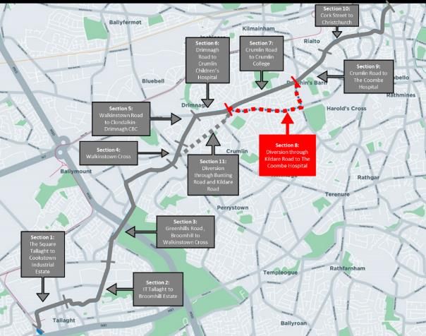
Contents
1.     Executive Summary ............................................................................................................................. 3
     1.1      Objective of the Scheme ............................................................................................................. 3
     1.2      Purpose of the Non-Statutory Public Consultation ..................................................................... 3
     1.3      Public Consultation Process for BusConnects .............................................................................. 4
     1.4      Information Provided in Public Consultation .............................................................................. 6
     1.5      Submissions Received:................................................................................................................. 6
     1.6      Principal Issues Raised: ................................................................................................................ 6
2      Introduction ......................................................................................................................................... 7
3      Approach to Assessing the Submission ............................................................................................... 7
4      Analysis of Issues Raised by Section .................................................................................................... 7
5      Profile of those making submissions ................................................................................................. 10
6      Themes Raised in the Submissions .................................................................................................... 10
7      The Main Issues Raised ...................................................................................................................... 10
APPENDIX A
SUMMARY OF ISSUES RAISED, PER SECTION OF ROUTE ...................................................................... 22
APPENDIX B
SUMMARY OF ISSUES RAISED, BY TOPIC .............................................................................................. 48

                                                                              2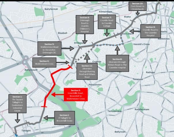
1. Executive Summary

1.1 Objective of the Scheme
 The aim of BusConnects is to transform Dublin’s bus system, with the Core Bus Corridor project
 providing 230kms of dedicated bus lanes and 200km of cycle lanes on sixteen of the busiest bus
 corridors in and out of the city centre. This project is fundamental to addressing the congestion issues
 in the Dublin region with the population due to grow by 25% by 2040, bringing it to almost 1.55m.

 This report focusses on the Core Bus Corridor which runs from Tallaght to the City Centre (Route 9),
 via Greenhills. Other lines connect with this corridor at various points along the route; Line 8 joins at
 Walkinstown Road, Line 11 meets at Patrick Street and Line 7 meets it at Christchurch Square.

1.2       Purpose of the Non-Statutory Public Consultation

The statement below sets out the purpose of the public consultation, as presented on the BusConnects
website:
The BusConnects programme aims to transform Dublin’s bus system, with the Core Bus Corridor project
providing 230kms of dedicated bus lanes and 200km of cycle lanes on sixteen of the busiest bus
corridors in and out of the city centre. This project is fundamental to addressing the congestion issues in
the Dublin region with the population due to grow by 25% by 2040, bringing it to almost 1.55m.
The bus service is the main form of public transport across Dublin with 67% of public transport journeys
each day made by bus. The level of commuting to work by bicycle has also increased by 43% since 2011
and the need for better and safer cycling facilities will be provided through the roll-out of the core bus
corridor project.

The first phase of the public consultations commenced in November 2018 and is on-going. The latest
public consultation for phase two is commencing today on the Emerging Preferred Routes for the
following six corridors:

      •    Liffey Valley to the City Centre

      •    Clondalkin to Drimnagh

      •    Greenhills to the City Centre

      •    Tallaght to Terenure

      •    Kimmage to the City Centre

      •    Rathfarnham to the City Centre
On the six corridors announced today, annual passenger growth in Dublin Bus services has increased by
up to 19% in the period 2015 to 2018. However, the millions of passenger journeys taking place on each
of these corridors are facing increasing congestion with delays being frequently experienced by
commuters.
All property owners potentially affected by today’s announcement have been notified by post with one-
to-one meetings being offered in the coming weeks with those potentially impacted.

                                                     3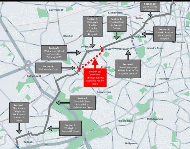
Phase Three of the Core Bus Corridors project will get underway in mid-February and will run until the
end of April featuring the final six corridors: Ballymun to the City Centre; Finglas to Phibsborough; Bray
to the City Centre; Blackrock to Merrion; UCD Ballsbridge to City Centre and Ringsend to the City Centre.

Anne Graham, CEO of the NTA said: “Today marks the second stage in a three-step process with details
being unveiled of six additional Emerging Preferred Routes foreseen under the BusConnects Core Bus
Corridor project. In recent days, we have notified the 665 property owners along these routes who may
be potentially affected and offered one-to-one meetings to inform them of the proposals and listen to
their feedback.
“We would encourage those who received the notification to get in contact with us and engage in the
consultation process that runs until the 29th March. We want to hear from them to get their views on
the proposals and the issues that they wish to see addressed.

“At the NTA, we are determined to deepen our engagement with the communities along each of the
identified corridors. That is why in addition to the meeting with potentially affected property owners we
will also be organising public information events and Community Forums along each of the six corridors
announced today.
“The Community Forums, in particular, will ensure a two-way dialogue with community leaders,
residents’ associations, special interest groups and public representatives. We are eager to listen to the
concerns of all those affected, and we will ensure they are kept updated on the project as it progresses.

“We have been encouraged by the positive level of engagement the NTA has witnessed since the launch
of the Core Bus Corridors project public consultation in November 2018 and we will examine all
observations carefully over the coming weeks as we look to develop Final Preferred Routes.

“Although we are aware that a project of this scale will bring many challenges, the BusConnects Core
Bus Corridor project is needed now more than ever. With the city due to expand by 25% by 2040,
continuous bus priority and segregated cycle lanes will be required to meet the growing demand for
fast, reliable, punctual and convenient bus journeys in and out of the city centre, and safe cycling
facilities for the growing numbers of cyclists.”

1.3   Public Consultation Process for BusConnects

Consultation on the BusConnects Core Bus Corridor Project took place on a phased basis and ran until
the 31st May 2019. The first phase of consultation occurred from 14th November 2018 to 29th March
2019. The second phase ran from 23rd January 2019 to the 30th April 2019 and the final phase ran
from 26th February 2019 until the 31st May 2019. The emerging preferred routes within each phase
have been listed below;

Phase 1: 14th November 2018 to 29th March 2019
1.      Clongriffin to City Centre;
2.      Swords to City Centre;
5.      Blanchardstown to City Centre; and
6.      Lucan to City Centre.

Phase 2: 23rd January 2019 to 30th April 2019
7.      Liffey Valley to City Centre;
8.      Clondalkin to Drimnagh;

                                                     4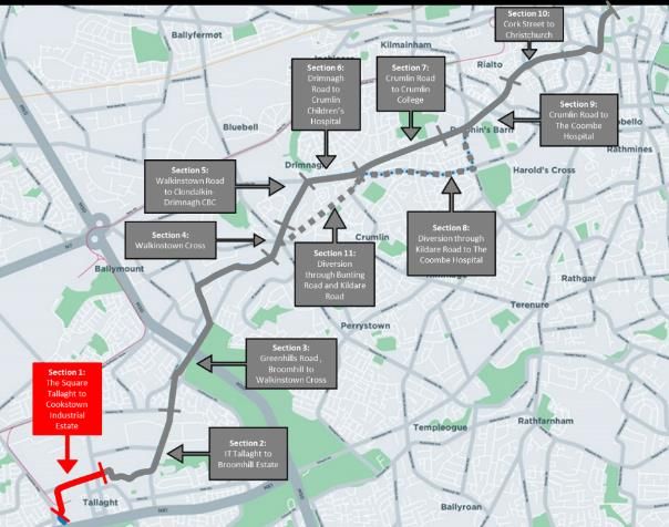
9.      Greenhills to City Centre;
10.     Tallaght to Terenure;
11.     Kimmage to City Centre; and
12.     Rathfarnham to City Centre.

Phase 3: 26th February 2019 to 31st May 2019
3.      Ballymun to City Centre;
4.      Finglas to Phibsborough;
13.     Bray to City Centre;
14.     UCD Ballsbridge to City Centre;
15.     Blackrock to Merrion; and
16.     Ringsend to City Centre.

The Greenhills to City Centre emerging preferred route formed part of the second phase of
consultation, which closed on the 30th April 2019. The location of each of the emerging preferred
routes can be seen below in Figure 1 below.

                    Figure 1: Radial Core Bus Corridors Emerging Preferred Routes

                                                   5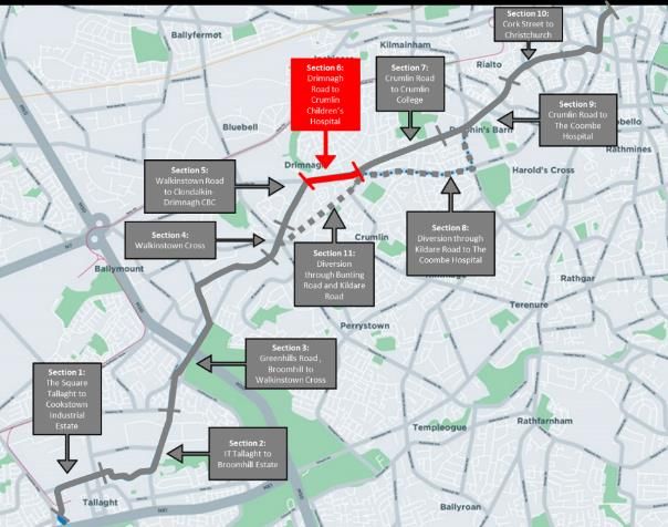
1.4 Information Provided in Public Consultation
 The Public Consultation document provided information about the work that has been carried out as
 part of BusConnects Core Bus Corridor Study. Additional information was provided on the official
 BusConnects website:

 https://www.busconnects.ie/initiatives/core-bus-corridor-project/

 The additional supporting information on the website included:

        •   Greenhills to City Centre Core Bus Corridor Options Study, Volume 1: Feasibility and
            Options Assessment Report, January 2018
        •   Greenhills to City Centre Core Bus Corridor Options Study, Volume 2: Feasibility and
            Options Assessment - Appendices, January 2018
        •   Greenhills to City Centre Core Bus Corridor (Tallaght to City Centre), Volume 2: Drawings,
            Rev CD4, February 2017

1.5   Submissions Received:
 There were 87 submissions received for the Greenhills to City Centre Core Bus Corridor. These
 submissions ranged from personal submissions sent in by residents, commuters and local
 representatives, to detailed proposals from public bodies, various associations and private sector
 businesses. In addition to the submissions received, notes taken by the NTA during meetings with
 impacted landowners are included in summary of issues raised in this report.

1.6 Principal Issues Raised:
 The responses cover a wide spectrum of views. The majority of the views raised concerns about the
 scheme, or elements therein. A limited number of the submissions were positively supportive of the
 scheme; some others had only qualified support. Some submissions identified positives within the
 scheme, while challenging other elements of the overall scheme.

 The issues raised included:
        1) Rerouting of Existing Bus Services
        2) Environmental Issues
        3) Issues During Construction
        4) Cyclist Safety
        5) Pedestrian Safety
        6) Security
        7) Impact on Local Businesses
        8) Integration
        9) Non-Compliance with Design Standards and Planning Documents
        10) Walkinstown Cross Design Issues
        11) Loss of Parking Facilities

                                                   6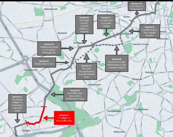
12) Route and Design Issues
        13) Loss (property value, revenue, loss of function, privacy etc.)
        14) Traffic Calming Issues
        15) Disability Issues
        16) Financing the Scheme
        17) Suggestions and New Ideas

2 Introduction
Consultation on the Greenhills to City Centre Core Bus Corridor Emerging Preferred Route ran between
the 23 January 2019 to 30 April 2019.

Every property owner potentially affected by the proposals was notified by post on the week
commencing 21 January 2019 and a one-to-one meeting was offered in each case.

Public Information Events were held at the following locations:

•       Red Cow Morans Hotel, Naas Road, 26 February 2019.

•       Dublin City Council Civic Office, 12 March 2019.

A Community Forum Event was held at the following location:

•       Our Lady’s Hall, Drimnagh on Tuesday 12 February 2019.

Copies of the Core Bus Corridor Emerging Preferred Route Brochure were available to the public at the
Public Information Events, and could be sent by post on request, or for pickup at NTA Office reception,
and the Brochure was available for downloading from the BusConnects dedicated website. Relevant
background technical reports were also available for downloading from the BusConnects dedicated
website.
The public were invited to make written submissions relating to the content of the Greenhills to City
Centre Core Bus Corridor Emerging Preferred Route. Submissions could be made by post; by email; or
by hand-delivery directly in the reception of the Authority’s offices.

3 Approach to Assessing the Submission
 The review of the submissions commenced in June 2019 once the consultation period for all three
 phases had closed. The NTA received 87 no. submissions for the Greenhills to City Centre emerging
 preferred route, from the 23 January 2019 to 30 April 2019. All submissions were entered into a
 database. The observations on the Greenhills Scheme also included a Petition form the Crumlin Road
 Residents Group signed by over 300 individuals.

4 Analysis of Issues Raised by Section
 The corridor was divided into the sub-sections, and the issues raised in each submission was entered
 and categorised in the database by geographical section, by issues type and comment type.

                                                    7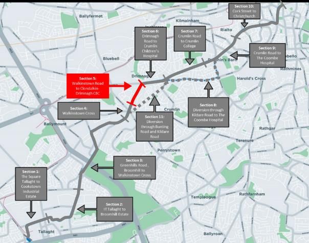
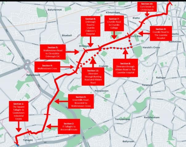
Figure 2: Greenhills to City Centre Corridor Map

The eleven sections included:

   •   Section 1: Belgard Square West to Belgard Road (Technology University Dublin, Tallaght);
   •   Section 2: Belgard Road (R113) to Mayberry Road (L3018), via TUD Tallaght and Greenhills Road
       (R819)
   •   Section 3: Mayberry Road (L3018) to Mulcahy Keane Estate, via Greenhills Road (R819),
       Ballymount Avenue, Calmount Avenue and Greenhills Road.
   •   Section 4: Walkinstown Roundabout and approaches.
   •   Section 5: Walkinstown Road (R819).
   •   Section 6: Drimnagh Road (R110), between Walkinstown Road and Kildare Road.
   •   Section 7: Crumlin Road (R110), between Kildare Road and Sundrive Road.
   •   Section 8: Kildare Road and Sundrive Road (alternative cycle route).
   •   Section 9: Sundrive Road to The Coombe Hospital, via the Crumlin Road (R110).
   •   Section 10: The Coombe Hospital to Christchurch, via Cork Street (R110), The Coombe, Patrick
       Street (R137) and Nicolas Street (R137).
   •   Section 11: Bunting Road and St Marys Road, between Walkinstown Roundabout and Kildare
       Road (alternative cycle route).

                                                  8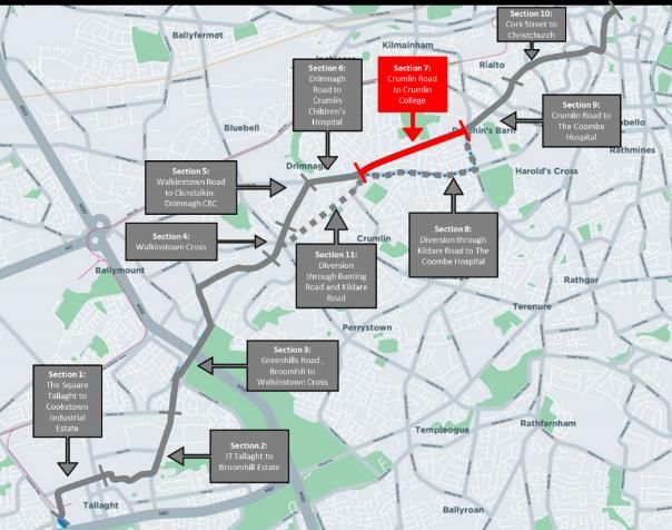
The issues raised in each submission was entered and categorised in the database by geographical
section, by issue type and comment type. In addition to the 11 sections, submissions were also
categorised as ‘The Entire Scheme’ where the submission referred to multiple areas, or the scheme as
a whole.
Figure 3 and Table 1 below show the distribution of the submissions with comments across the various
sections of the scheme:

                         Figure 3 Distribution of Submissions by Section on Line 9

                               Table 1: Distribution of Comments by Section

                                                                 Number of             Percentage
                                                                 Comments within
                                                                 the 87 submissions
 Section 1: The Square Tallaght to Cookstown Industrial Estate            13              3.1%
 Section 2: IT Tallaght to Broomhill Estate                               21              5.0%
 Section 3: Greenhills Road, Broomhill to Walkinstown Cross               34              8.0%
 Section 4: Walkinstown Cross                                             24              5.7%
 Section 5: Walkinstown Road to Clondalkin-Drimnagh CBC                   16              3.8%
 Section 6: Drimnagh Road to Crumlin Children’s Hospital                  25              5.9%
 Section 7: Crumlin Road to Crumlin College                               34              8.0%
 Section 8: Diversion through Kildare Road and Sundrive Road              24              5.7%
 Section 9: Crumlin Road to The Coombe Hospital                           31              7.3%
 Section 10: Cork Street to Christchurch                                  46              10.8%
 Section 11: Diversion through Bunting Road and Kildare Road               5              1.2%
 General : Whole Route                                                    151             35.6%
 Total to-date                                                            424             100%

                                                      9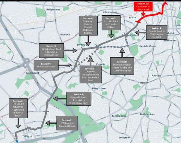
5 Profile of those making submissions
Of the 87 individual submissions received:
•    83% were from residents of the study area and typically referred to local matters;
•    17 % from others.

6 Themes Raised in the Submissions
 All 87 of the submissions received by the NTA were reviewed and the issues raised were
 categorised, summarised and analysed. A total of 10 main themes were identified during this review
 process.

            Table 2: Themes and frequency associated with public consultation comments.

    Theme                                                Frequency
    Accessibility/ Traffic Impact                                         60 comments
    Pedestrian and Driver Safety                                          20 comments
    Cyclist Safety                                                        64 comments
    Suggestions and New Ideas                                             36 comments
    Environmental Sustainability                                          67 comments
    Integration and Compliance                                            31 comment
    Social and Community Impact                                           66 comment
    Land Use                                                              35 comments
    Heritage                                                               8 comments
    Economy                                                               37 comments

 Appendix A/B provides in-depth listing of the various issues raised in each section.

7 The Main Issues Raised
 In this regard, this report identifies the key issues raised in the public consultation process. The
 Authority will seek to establish the validity of the concerns, the potential consequences for the project,
 and how best to address the issue and /or mitigate the negative impact.
 While a variety of matters were raised in the submissions, the key issues related to the project are as
 follows:
         1) Rerouting of Existing Bus Services
         2) Environmental Issues
         3) Issues During Construction

                                                    10
4) Cyclist Safety
5) Pedestrian Safety
6) Security
7) Impact on Local Businesses
8) Integration
9) Non-Compliance with Design Standards and Planning Documents
10) Walkinstown Cross Design Issues
11) Loss of Parking Facilities
12) Route and Design Issues
13) Loss (property value, revenue, loss of function, privacy etc.)
14) Traffic Calming Issues
15) Disability Issues
16) Financing the Scheme
17) Suggestions and New Ideas
The nature of the issue, and the proposed NTA response to it, is covered in the following sections.
7.1 Issue 1: Rerouting of Existing Bus Services
The loss of several existing services, namely the Dublin Bus Routes 15A, 18, 123, has caused some
concern amongst residents. This concern is due to the proposed route not encompassing all the areas
that the previous services did, leaving many residents unable to get to work, school or local amenities.
This will particularly affect the elderly and those with mobility issues. In addition the requirement to
now change buses to get to locations that previously only required one bus has garnered objection due
to the inconvenience and increased journey time. Again this will impact the elderly and disabled as
they may have to alight at one stop and walk to another to get a connection.
NTA Response to Issue 1:
The issues highlighted above relate to the BusConnects Bus Network Redesign which is subject
to a separate public consultation process.
7.2 Issue 2: Environmental Issues
One of the largest concerns amongst residents was the potential negative impact the scheme and its
construction will have on the environment. The potential increase of noise level due to the
construction of the route along with the proximity of the buses and cars to properties has been flagged
as a potential major issue. Additionally the assumed increase of air pollution and light pollution the
scheme would bring, particularly along the Crumlin Road, has not been welcomed. The lack of
information published in regards to these has led to criticism. The removal of trees and greenspace in
locations such as the central median at Christchurch, and along Crumlin Road has been objected to as
it seems unnecessary.
11NTA Response to Issue 2:
Under the Bus Connect programme the NTA will be upgrading the existing bus fleet to
transition to a fleet of low emission vehicles which will reduce both noise and air pollution. By
2023 half of the bus fleet, approximately 500 buses, will be converted to low emission vehicles,
with full conversion completed by 2030.
As part of this planning process a detailed Environmental Impact Assessment Report (EIAR) is
being prepared which will assess the impact of the proposed BusConnects proposals on Dublin.
This will look at air, noise and many other environmental impact of the proposed schemes and
will be submitted to the planning authorities for assessment. This will also be available for
public review when the application is submitted.
The impact on trees will be more accurately quantified during the detailed design stage, with
further appropriate options to minimise the impact on trees developed and assessed where
feasible.
7.3 Issue 3: Issues During Construction
Some issues that may arise during construction include possible structural damage and subsidence,
particularly caused by vibrations. The stabilisation of home walls and foundations is of concern to
residents. There may be disruptions caused to existing utilities such as electricity, water and
communications. Households feel they may be at risk of disease due to the disturbance of vermin
due to the large scale nature of road works disruption and construction. Natural drainage of the area
may be impacted due to the increase in pavement surfaces and reduction in green spaces, potentially
posing a flooding hazard. Residents and businesses are also concerned about accesses to properties
during construction.
NTA Response to Issue 2:
As part of the detailed design and construction process careful consideration is given to the
impacts during construction. This will include visiting properties where identified and
undertaking surveys with the agreement of the occupiers.
Existing above and below ground utilities will be mapped during the design process and will be
provided to the contractor who will be required to confirm their location before construction
begins. This will minimise the likelihood of disruption during construction, however where a
utility is impacted the contractor will have measures in place to rectify the issues quickly.
Construction Traffic Management Plans will be created during the design stage so as access is
always maintained. Where access is to be restricted this will only be done in consultation with
the occupier, with the duration minimised.
12The potential impacts of the proposed scheme will be fully quantified as part of the
Environmental Impact Assessment (EIA) process which will be carried out by the NTA during the
preparation of a planning application for the scheme.
7.4 Issue 4: Cyclist Safety
A large number of submissions addressed the safety of cyclists on this route. The proposed removal
of dedicated cycle lanes on Crumlin Road meaning they will have to compete with double decker
buses for road space or being forced to cycle on the now reduced footpath is of great concern. It is
crucial that buffers, raised tables and other measures are used at junctions due to the volume of
large vehicles and HGV’s along this route. Cyclists have not fully been provided for when turning at
locations such as the Long Mile Road/ Walkinstown Road Junction and the Crumlin Road/ Drimnagh
Road Junction. Proper segregation at Christchurch should be considered due to poor layout. Filtered
permeability and hard methods of segregation should be provided. The Kildare Road Cyclist Detour
fails to meet the five needs of a cyclist set by the National Cycle Manual. The route is both unsafe and
indirect and has a history of fast through traffic. There are a number of instances of drive through bus
stops along the route; these pose a risk to cyclists and pedestrians. These should be replaced with
bus stop bypasses.
NTA Response to Issue 4:
The designs at this stage of planning are preliminary in nature, and will require significant
additional work to bring them to a point where the NTA is prepared to submit the overall
proposal for planning consent. The various issues raised in this consultation process will also
feed into the designs.
On Crumlin Road the limited road width and the necessity to provide bus priority on this
congested link limits the potential to provide cycle facilities on this street. An alternative cycle
route via Kildare Road and Clogher Road is now proposed which includes higher quality cycle
facilities along quieter street.
7.5 Issue 5: Pedestrian Safety
The provision of shared spaces throughout the scheme should be revised as these provide a low level
of service for all road users. Bollards and buffers should be included to segregate pedestrians. There
are concerns that the proposed high quality cycle lanes as part of the BusConnects program will come
at the cost of pedestrians and their safety. Throughout the scheme the footpath is currently often
blocked by illegal on street parking; more aggressive parking deterrents should be implemented. Grass
verges and planting of trees may mitigate this issue. The time required to cross the road will need to
be extended due to road widening to ensure safe crossing of pedestrians, particularly the elderly. The
removal of central reserves will put pressure on vulnerable pedestrians. Pedestrian desire lines should
be taken into account.
13NTA Response to Issue 5:
The designs at this stage of planning are preliminary in nature, and will require significant
additional work to bring them to a point where the NTA is prepared to submit the overall
proposal for planning consent.
7.6 Issue 6: Security
Lighting is only provided on the northern side of the Greenhills Road and is not sufficient at several bus
stop locations; this has raised concerns for pedestrian security. It has been noted that bus shelters can
lead to antisocial behaviour. Additionally the increased proximity of pedestrians to residences has
been raised as an issue on the Crumlin Road as there have been a series of burglaries in the area over
the last few years; there is concern in regards security and further exposure. There is potential for
increase in opportunistic crime due to the loss of driveway car parking and having to park further from
houses. The lack of natural public surveillance and a decrease in perceptions of personal security may
be an issue for night-time users of bus stops and pedestrians in general.
NTA Response to Issue 6:
Lighting will be upgraded on all roads which are being upgraded as part of the BusConnects
Programme and will be in line with current best practise in terms of lighting levels.
Where road widening is taking place the boundary treatments (walls and gates) will be replaced
with similar arrangements to the existing layout and in agreement with the landowners (see
Issue 13).
The proposed widening along Crumlin Road has been reduced substantially to that which was
indicated on the original EPR and as a result the existing boundaries will not be impacted.
The potential impacts of the proposed scheme will be fully quantified as part of the
Environmental Impact Assessment (EIA) process which will be carried out by the NTA during the
preparation of a planning application for the scheme.
7.7 Issue 7: Impact on Local Businesses.
Early morning deliveries are an important aspect of the central distribution system and it is important
that these deliveries are accommodated and restrictions on access are limited. Bus stop locations are
14not suitable for the aging population, local businesses may see reduced trading and the potential
foreclosure due to lack of frequent and accessible bus stops. Additionally the loss of on street parking,
particularly during construction, could potentially affect local businesses and may lead to a loss of
customers. All six corners of the Walkinstown Roundabout are currently used for car parking, which is
removed in the NTA maps. There is sufficient space at Crumlin Road/ Windmill Road Junction (Iveagh
Gardens) to provide dedicated parking for local shops and businesses.
NTA Response to Issue 7:
The NTA will work with local business to minimise the impact of the construction stage of the
BusConnects project on their businesses. Access will always be maintained and loading/parking
will be facilitated in the vicinity so as businesses can continue to operate as normal.
Currently just 25 on-street parking spaces are removed over the 11km length of Line 9.
The bus stop locations have been optimised throughout Line 9 and in general they are located
close to businesses, and key destinations, as they are key attractors for bus passengers.
7.8 Issue 8: Integration
There are several routes of the Greater Dublin Area Cycle Network Plan (GDA CNP) that pass through
or connect with the Greenhills Scheme such as primary Route SO5 along Belgard Road, Secondary
Routes 7E and 8A. Junctions that meet these GDA CNP routes should be designed in such a way that
the CNP can be completed without redesigning or reconstructing these junctions. It should be safe and
protected at these dedicated cycle routes. South Dublin County Council proposes to construct a link
road connecting Belgard Road and Cookstown Road. It is also proposed to provide an on-road cycle
track along Belgard Square North. Details of this scheme will need to be incorporated into the
BusConnects proposal.
NTA Response to Issue 8:
The designs at this stage of planning are preliminary in nature, and will require significant
additional work to bring them to a point where the NTA is prepared to submit the overall
proposal for planning consent.
The future proposals will also take account of connections to other cycle routes noted on the
GDA Cycle Network Plan as well as new road schemes.
Additional sections of cycle lane are being included in the BusConnects proposals, including a
segregated cycle route along Belgard Square North.
157.9 Issue 9: Non-Compliance with Design Standards and Planning Documents
The proposal is not socially inclusive of all means of transport; it proposes to remove an existing cycle
track in order to provide for both cars and buses, which contravenes the Dublin City Development Plan.
This design does not promote the reduction of car usage or encourage cycling as outlined in the National
Planning Framework. In contradiction to the National Cycle Policy Framework, the proposed cycle lanes
are circuitous and non-designated – the proposal to reroute tracks but yet allow shared space with
buses if one chooses the more direct path will, especially at peak hours, present a significant safety
issue.
There are several instances throughout the route where left turn slip lanes have been indicated. Left
turning slip lanes or streaming lanes are stated as being non-compliant with the NTA’s National Cycle
Manual (NCM), section 4.4.4, which states streaming lanes can only be used in low traffic speed
environments and are not suitable for HGV routes (the high HGV flows in this area were noted). A
further contradiction to DMURs is the prioritisation of buses and cyclists over pedestrians.
NTA Response to Issue 9:
The designs at this stage of planning are preliminary in nature, and will require significant
additional work to bring them to a point where the NTA is prepared to submit the overall
proposal for planning consent.
On all schemes the NTA is reviewing the design of cycle facilities at junctions in order to
remove left turn lane conflicts, remove shared pedestrian/cycle space where possible and to
provide more segregation through junctions.
7.10 Issue 10: Walkinstown Cross Design Issues
The safety of all road users of this junction is in question with the emerging preferred route proposal.
The cause of congestion in the area is the build-up of vehicles at this roundabout due in inaccessibility
to the M50 Northbound, M50 Southbound, Tallaght, South Dublin, City Centre and West Dublin. The
redesign of this junction shows no improvement to the existing layout. It should not mix pedestrians
and cyclists; uncontrolled crossings over two entry lanes would be unsafe and inconvenient; signalized
crossings would be better. Residents of Greenhills Road have concerns regarding the pedestrian
crossing just before the Walkinstown Cross Roundabout, as drivers often break the red light. Traffic
calming measures should be implemented on all approaches to the roundabout.
There are a variety of cyclist issues at this location with regards to safety, accessibility and traffic which
are outlined in the Appendices. Additionally, there are queries regarding the two existing electric
vehicle charging points at this location and whether they will be maintained.
16NTA Response to Issue 9:
The designs included in this public consultation exercise have been assessed for feasibility and
safety against the relevant design standards. Nonetheless, the designs are preliminary in
nature, and will require significant additional work to bring them to a point where the NTA is
prepared to submit the overall proposal for planning consent.
The Layout of the Walkinstown Roundabout has been revised to include segregated cycle
facilities and signalised pedestrian and cycle crossings on all arms. In addition, traffic calming
ramps will be provided on the approaches to the junction to slow traffic down.
7.11 Issue 11: Loss of Parking Facilities
One parking space per residence is not sufficient for the local demographic; parking is required for
carers, health nurses, doctors and family daily. Some residences require secure driveway parking for
work vehicles. The requirement to take approximately two metres from properties and the removal of
on-street parking will have negative impacts on most residents on Crumlin Road as they typically have
more than one car. Parking their vehicles further from their home will render those targets for
opportunistic crime. This is a particular concern of residents of Crumlin Road, Walkinstown Road and
Drimnagh Road. The parking of vehicles on laneways surrounding Drimnagh Road for residents, shops
and local businesses should be restricted to residents only.
NTA response to Issue 11:
The NTA has reviewed proposed land acquisition with respect to its impact on parking within
private properties. As a result of this review the proposals have been altered on Crumlin Road
and it is now not proposed to widen the road over its entire length, as the impacts on
driveways would be too severe in many cases due to the length and gradient of the remaining
driveway. The proposed layout on Drimnagh Road has also been reviewed and impacts on
residential properties minimised through a reduction in lane widths. Due to the congestion
being experienced by buses on Walkinstown Road and the larger gardens along its length it is
not proposed to alter the proposals in this location.
Therefore, the current scheme proposal has reduced the impact on off-street parking when
compared to the Emerging Preferred Route published in February 2019, in particular in the
areas of Crumlin Road and Drimnagh Road.
177.12 Issue 12: Route and Design Issues
A number of junctions on Greenhills Road have not been provided with right turn lanes. This will result
in low capacity junctions with right turning traffic causing congestion at peak times. There is strong
suggestion to close vehicle access to and from Ballymount Road Upper. This is a narrow junction with
a steep dangerous climb out onto Greenhills Road. The no right turn at Walkinstown/ Kilnamanagh
may lead to excessive U-turns along Walkinstown Road. The addition of two “no-right turn” signs at
Kilnamanagh Road will encourage a rat run through the SuperValu car park in order to gain access to
Kilnamanagh Church, and local schools from Walkinstown Road.
Currently no left turn from Walkinstown Road onto Long Mile Road. This is not shown in NTA Maps. If
right turn is removed at Kilnamanagh Road, Walkinstown Road residents are required to travel to
Walkinstown Avenue in order to join westbound Long Mile Road. As seen in the Appendices, there are
instances where a “no left turn” or a “no right turn” should be removed or included.
The use of Slane Road as a cycle route is questionable due to conflict with local traffic on a narrow
street. Continue cycle lane through Clogher Road to join up the Canal Way Cycle Route. The addition
of an outbound traffic lane should be reversed in order to provide an inbound cycle lane instead. Desire
lines of cyclists need to be considered. They will take the most direct route rather than a diversion as
Bunting Road.
NTA Response to Issue 12:
The designs at this stage of planning are preliminary in nature, and will require significant
additional work to bring them to a point where the NTA is prepared to submit the overall
proposal for planning consent.
In relation to the specifics mentioned above:
- Right Turns on Greenhills have been reviewed and additional right turn facilities provided.
- It is now proposed to close the road from Ballymount to Greenhills as a new road catering for
this movement will be available.
- The various bans which were proposed as part of the EPR have been reviewed and where
appropriate altered.
- The alternative cycle route is now on Clogher Road (to the Grand Canal) and not Slane Road
as proposed in the EPR.
7.13 Issue 13: Loss of property value, revenue, loss of function, privacy etc.
Loss of land in front gardens and driveways is of concern to many residents along the route. Many
requests for remedial works such as: new front walls, triple-glazed window, new front door, driveway
18to be re-laid, sufficient internal and/or external insulation to eliminate noise pollution. Residents are
concerned about the loss of property value due to CPO land take and the proximity of the carriageway.
An additional concern is the loss of privacy due to the increased frequency in which double decker buses
will be passing their homes at a closer distance to their windows. Residents and locals fear that the
approach to urban design and regeneration and the resulting urban fabric, which to date remains
unfinished and unhospitable, will produce similar results to Cork Street.
Affected residents who are contacting the NTA are being anecdotally told that there will be generous
compensations that gardens will be reinstated, and that triple glazing will be installed to reduce noise
in homes, all as part of a compensation package. Query whether these items will form part of a CPO
compensation package or will merely be deducted from the ultimate compensation amount.
NTA Response to Issue 13:
Potential land acquisition is envisaged and the NTA will engage readily with landowners
potentially impacted by the proposed scheme. Should a Compulsory Purchase Order be
required, this process will fairly assess the impact of the proposed scheme on properties and
provide for mitigation measures including for the construction of new boundary walls.
The potential impacts of the proposed scheme will be fully assessed as part of the
Environmental Impact Assessment (EIA) process which will be carried out by the NTA during
the preparation of a planning application for the scheme.
7.14 Issue 14: Traffic Calming Measures
Tallaght Square and Village need to recognise the need to reduce speeds to 30 KPH.
At night vehicles have a clear run from Crumlin Children’s Hospital to Sundrive Road as traffic lights
along this stretch are solely pedestrian crossings. The lack of traffic calming measures promotes
excessive speed in this area. The widening of this road will further exacerbate this issue. The lack of
enforcement of speed limits on Crumlin Road and two bus lanes will allow buses to travel at increased
speed. Crumlin Road should have a 50 KPH speed limit that is actively enforced. Road lane widths
should be reduced to below 3.25 metres.
19NTA response to Issue 14:
The proposed BusConnects scheme is not expected to increase speeds, in fact they will most
likely decrease as a result of narrower vehicle lanes being used. In addition, traffic calming
measures are being proposed as part of the proposals at some locations which will slow
vehicles down. During the detailed design stage the traffic signal timings will be optimised to
reduce the speeds of traffic travelling along the R110 during off peak periods.
7.15 Issue 15: Disability Issues
Bus stop locations at greater than 400 metre intervals are not acceptable for people with disabilities,
children or the aging population. Uncontrolled junctions are treacherous for the visually impaired.
Footpaths of one material, preferably a non-slip surface with grainy feel so guide dogs easily navigate.
At crossing points, tactile paving should be used and the kerb should slope gently to allow wheelchair
users and prams to cross the road safely. Directional tactile paving should also be implemented to
show the direction of the crossing. Where bus shelters are provided, they should be located as close
to the edge of the path as possible and should not hinder pedestrians passing behind them. Tactile
paving should also be used to warn of their presence. The design of bus shelters should not lead to
many obstructions and protrusions onto the footpath.
As previously mentioned the need to change buses will hugely hinder the travel of the elderly and
disabled.
NTA Response to Issue 15:
The designs at this stage of planning are preliminary in nature, and will require significant
additional work to bring them to a point where the NTA is prepared to submit the overall
proposal for planning consent.
7.16 Issue 16: Financing of the Scheme
The capital expenditure budget associated with this project has been published in the media as in the
region of €2 billion. To note in comparison the cost of Luas Green & Red lines was €728 million. There
were many concerns regarding the discrepancy in costs of these two projects. Submissions asked will
each route be operated as a separate project in terms of financing, procurement, planning, etc.
20NTA response to Issue 16:
As part of the BusConnects planning process an Outline Business Case is being prepared. This
will be continuously updated as more accurate information becomes available during the
design process and issued to Government for final approval.
The planning and construction sequencing will be established over the coming months as the
design develops.
7.17 Issue 17: Suggestions and New Ideas
There were a plethora of suggestions and new ideas to take into consideration for this scheme. These
are detailed in the Appendix B. Examples of such suggestions include the provision of a connection
through Limekiln Road across to the Kingswood Luas Stop and allowing a connection over to the A Bus
Route in Templelogue. Another suggestion to be considered was the closure of one of the two
entrances to Hibernian Industrial Estate to improve the overall safety of cyclists and pedestrians and
reduce potential conflicts.
Other suggestions for this route were the introduction of a contraflow system and a congestion charge
within the area of the Grand Canal, and/or a bus route alternation which includes the Naas Road.
NTA Response to Issue 17:
The designs at this stage of planning are preliminary in nature, and will require significant
additional work to bring them to a point where the NTA is prepared to submit the overall
proposal for planning consent.
21APPENDIX A
SUMMARY OF ISSUES RAISED, PER SECTION OF ROUTE
22Section 1: The Square Tallaght to Cookstown Industrial Estate
Main comments noted were the following:
GENERAL:
• Cycling facilities have not been provided.
• Belgard Square West is local access only, so the need for bus lanes and general traffic lanes should
be examined. Reducing the vehicular carriageway to two lanes and removing the central hatching
would allow space to provide segregated cycle facilities.
• Tallaght Square and Village needs to recognise the need to reduce speeds to 30 kph.
• Alterations to existing traffic management layout may cause traffic to back up through existing
junctions and cause traffic congestion at this location.
• Major developments are planned within the area occupied by the Square Shopping Centre. The
proposed layout along Belgard Square West will restrict access to the shopping centre.
MAP 2:
• Due to the range of retail facilities at The Square Shopping Centre Tallaght, sufficient vehicular
access needs to be maintained for customers. It is requested that the NTA carefully consider how
delivery access to the shopping centre will be maintained as part of future design proposals.
23MAP 3:
• South Dublin County Council propose to construct a link road connecting Belgard Road to
Cookstown Road. The works will consist of a 6m carriageway, 2 x 2m raised cycle tracks on either
side and a new footpath on the eastern side of the road. Details of this scheme will need to be
incorporated into BusConnects proposals.
MAP 4:
• This area is well served by various public/ private car parks, so the provision of on-street parking
should be reconsidered.
• Belgard Square North should be reviewed to provide cycle tracks; could be achieved by restricting
the road to local access only, with the Tallaght bypass carrying through traffic. Alternatively make
the road one-way for traffic.
• Primary Route SO5 of the Greater Dublin Area Cycle Network Plan runs along Belgard Road, so a
fully protected junction for cyclists should be provided at the Belgard Road/ ITT Access Road.
24Section 2: IT Tallaght to Broomhill Estate
Main comments noted were the following:
GENERAL:
• The proposal of a two-way cycle route through ITT is welcomed, as it will encourage greater usage
within and around the campus. It is recommended that the two-way cycle route is extended to
connect with the ITT entrance on Blessington Road/ Main Street.
• Unclear whether or not all junctions along this section will be signalised or not.
• Lack of natural public surveillance and a decrease in perceptions of personal security may be an
issue for night-time users of bus stops located along the ITT Access Road.
MAP 5:
• The cycle lane and bus stop location are dangerous; there is sufficient space to bring bus stop into
pavement as a bus stop bypass for cyclists.
MAP 6:
• Cyclists will use footpath to access the Gym (Westpark Fitness) and Football Club (St. Mealruan’s).
Currently cyclists remain on the footpath at the junction of ITT Access Road and Greenhills Road.
25• The proposed layout at the ITT entrance on Greenhills Road does not cater for right turning cyclists
either entering from the north or exiting to the south. This will create pedestrian-cyclists and bus-
cyclist conflicts.
• The southbound Greenhills Road cycle lane should be continuous through the T-junction.
• All arms of the junction should have controlled pedestrian crossings.
MAP 7:
• Remove inline bus stops.
• Cyclists turning left onto Airton Road will mount the kerb.
• Junctions should be raised and a buffer space should be provided between the road/ cycle track, to
remove cyclists out of HGV blind spots.
MAP 8:
• Shared space unacceptable at Broomhill Road Junction.
• Cyclists turning left onto Mayberry Road will mount the kerb.
• Junctions should be raised and a buffer space provided between the road/ cycle track, to remove
cyclists out of HGV blind spots.
• Suggestion to close one of the two entrances to Hibernian Industrial Estate to improve the overall
safety of cyclists and pedestrians and reduce potential conflicts.
• Safety of and provision for right turning cyclists both into/out of Mayberry Road needs to be
factored into the design.
26Section 3: Greenhills Road, Broomhill to Walkinstown Cross
Main comments noted were the following:
GENERAL:
• Greenhills Road is in poor condition and has a poor road layout. It is narrow, underdeveloped
and dangerous for all users. Greenhills Road needs development and widening to facilitate the
high number of bicycles and vehicles that use it each day.
• Greenhills Road to Walkinstown Roundabout designs need to be improved to keep cyclists and
HGV’s separate
• Greenhills Road thought to be underlain with limestone and may be subject to some protection
order to ensure limestone is not impacted.
• Potential impacts on the M50 Junction 10 Ballymount have not been addressed.
• A number of junctions on Greenhills Road have not been provided with a right turn lane. This
will result in low capacity junctions with right turning traffic causing congestion at peak times.
An option to be considered may be to terminate proposed bus lanes 25m from the stop line.
• Lighting is only provided on one side of the road (northern).
27MAP 9:
• Three inline bus stops shown here which are unacceptable.
• Recommendation for clear delineation of a cycle/ pedestrian link from the Old Greenhills Road
to the proposed Toucan Crossing.
MAP 10:
• Shared space over the M50 bridge is dangerous for both pedestrians and cyclists.
MAP 11:
• Shared space into an uncontrolled crossing meaning cyclists will continue to use footpath at
Ballymount Road Upper.
• Strong suggestion to close vehicle access to and from Ballymount Road Upper. This is a narrow
junction with a steep dangerous climb out onto Greenhills Road. The proposed re-routing of the
bus and main route onto Ballymount Avenue facilitates the easy access to and from this area via
Ballymount Avenue.
• It is crucial that buffer zones, raised tables and other measures are used at junctions due to the
volume of large vehicles at Ballymount Industrial estate.
MAP 12:
• Unacceptable inline bus stops.
MAP 13:
• Unacceptable inline bus stops.
• All four arms of the Calmount Road/ Ballymount Avenue junction are Secondary Routes (7E and
8A) of the Greater Dublin Area Cycle Network Plan, so a Dutch Style Junction should be
considered.
MAP 14:
• Unacceptable inline bus stops.
• New roundabout at the Lidl Junction is not welcomed, unless it is designed to safely cater for
cyclists and pedestrians.
• Cyclists travelling between Walkinstown and Tallaght area are likely to avail of the Old Greenhills
Road under this proposed scheme, as it will be quieter and generally safer.
MAP 15:
• Unacceptable inline bus stops.
MAP 17:
• Unacceptable inline bus stops.
28• Resident of Greenhills Road raised concerns regarding sewage outside their home, when
blocked it flows down the road; there are concerns of whether this will be an issue during
construction.
29Section 4: Walkinstown Cross
Main comments noted were the following:
MAP 18:
• The provision of a shared space at a roundabout is considered to be highly inappropriate,
particularly Walkinstown Cross. Cyclists will be approaching pedestrians from both sides.
• Unacceptable inline bus stops.
• The cause of congestion in the area is the build-up of vehicles at this roundabout due to accessibility
to M50 North, M50 South, Tallaght, South Dublin City, City Centre and West Dublin.
• The redesign of this junction should not mix cyclists and pedestrians.
• Redesign shows no improvement of existing roundabout layout.
• NTA map shows 4 lanes of traffic, currently there is only 3 lanes, yet there is no land acquisition
shown. How will the extra lane be provided?
• Consider the inclusion of traffic calming measures at all arms of this major roundabout.
• From a discussion at a community forum it is believed that cyclists will be required to dismount,
which is completely unacceptable.
• All six corners of this roundabout are currently used as car parking. Land take from these could
provide a Dutch Style junction.
30• If cycle facilities at all arms is not feasible, at least provide a bidirectional cycle track connecting
Greenhills Road to Bunting Road.
• The junction between Bunting Road and Cromwellsfort Road is not at all safe for cyclists. The
outbound cycle track suddenly disappears just before the junction. Inbound cyclists also inexplicably
lose their cycle track at the bend. It is not clear how an outbound cyclist on Bunting Road can re-
join cycle tracks on Greenhills Road, nor how they will make a right turn.
• Uncontrolled crossings over two entry lanes would be unsafe and inconvenient; signalised crossings
would be better, even if they would result in intolerably large amounts of time spent waiting to
cross.
• Routing cyclists around 4 exits to reach the cyclist detour from the Greenhills Road is appalling and
shows a lack of understanding with regard to cyclist safety.
• Suggestion that a signalised junction would be a better option instead of the roundabout.
• Residents of Greenhills Road have concerns regarding the pedestrian crossing just before
Walkinstown Cross Roundabout. Drivers often break the red light; traffic calming measures should
be implemented.
• Queries regarding the two existing electric vehicle charging points at the roundabout, will they be
maintained?
31Section 5: Walkinstown Road to Clondalkin-Drimnagh CBC
Main comments noted were the following:
GENERAL:
• Concerns regarding the loss of privacy and security for residences.
• Concerns regarding the removal of space to park cars.
MAP 19:
• Two additional lanes shown on NTA maps, yet only a small amount of land acquisition. This may
lead to narrower footpaths which puts vulnerable pedestrians, especially those with disabilities at
risk.
• The no right turn at Walkinstown/ Kilnamanagh Road may lead to excessive U-turns along
Walkinstown Road.
MAP 20:
• Vital that direct and safe access is provided during the construction phase from residences onto
Walkinstown Road.
32• The addition of two “no-right turn” signs at Kilnamanagh Road will encourage a rat run through the
SuperValu car park in order to gain access to Kilnamanagh Church, Assumption Secondary School
and Assumption Primary School from Walkinstown Road. This will impose a serious issue during the
AM Peak.
• Confusion with land take here. Road width shows 4 lanes yet only 2 lanes at present.
• Left turning cyclists from Long Mile Road onto Walkinstown Road are forced to share road with
buses and vehicles.
• Removal of pedestrian island at Long Mile Road junction is a safety concern.
• Footpath outside of bank on Map 20 has been greatly extended which may make bus turning
difficult from the Drimnagh Road onto Walkinstown Road.
33Section 6: Drimnagh Road to Crumlin Children’s Hospital
Main comments noted were the following:
GENERAL:
• At night vehicles have a clear run from Crumlin Children’s Hospital to Sundrive Road as traffic lights
along this stretch are solely pedestrian crossings. The lack of traffic calming measures promotes
excessive speed in this area. The widening of this road will further exacerbate this issue.
MAP 21:
• There are proposals to convert the car park at Walkinstown Road/ Balfe Road into housing which
will affect traffic counts. Provision for car parking elsewhere will need to be considered.
• Currently no left turn from Walkinstown Road onto Long Mile Road. This is not shown in NTA Maps.
If right turn is removed at Kilnamanagh Road, Walkinstown Road residents are required to travel to
Walkinstown Avenue in order to join westbound Long Mile Road.
• Shared space at Slievebloom Road and Drimnagh Road is unacceptable.
• Footpaths at this location are very wide and will be used by cyclists when lights are not in their
favour. This is done now and will continue to be done.
34• Inbound bus stop appears to be lengthened which may pose problems for buses turning onto Long
Mile Road, to get parallel at the stop for ramp access.
• No need for shared surfaces at Balfe Road and Slievebloom Road as cycle lanes have been provided.
• Major problem with footpath parking on Drimnagh Road outsides residences 133 to 147, where
land take is shown on map.
• The removal of the bus stop located outside the row of shops on Drimnagh Road should be reversed.
• The placement of bike lanes in the door zone of parked cars is dangerous.
• It is unclear why a bus stop layby is proposed at this junction, or why it needs to be double length.
Removing of the lay by would allow for a bus stop bypass to be provided.
• Cyclists wishing to turn right onto Walkinstown Road have to cross three separate pedestrian
crossings.
• For westbound traffic continuing along the Long Mile Road, a second general traffic lane appears
before merging again less than 200m later. This will not improve capacity or traffic flow. This space
should be reallocated to make the junction safer for cyclists.
MAP 22:
• Unacceptable inline bus stops.
• Three inbound bus stops outside Crumlin Children’s Hospital have been merged into one stop. This
will cause confusion to regular bus users.
• A bus lay by should be provided here as there is ample space.
• Local resident suggests the extension of the bus lane at Saint Mary’s Drive. The left turn into this
road is used very infrequently.
• Concerns raised regarding the loss of parking. If parking is removed from the main streets and roads,
it will lead to drivers parking their cars in residential estates and blocking homeowner’s access.
MAP 23:
• Cycle lanes should be marked going through junctions to prevent accidents.
• No cycle lane on Crumlin Road.
• No pedestrian crossing at Kildare Road.
• Diversion routes are too narrow and not suitable for van access.
• The proposed plan will make it difficult for a cyclist to travel westbound from the Crumlin Road to
the Drimnagh Road at the junction.
• Suggestion that land take should be taken from Crumlin Children’s Hospital due to the construction
of the proposed new children’s hospital.
35Section 7: Crumlin Road to Crumlin College
Main comments noted were the following:
GENERAL:
• The increase in width of Crumlin Road to a consistent four lane carriageway removes buses from
the traffic lanes and presents an unhindered route to the City Centre. This will increase car usage.
• Reduction of privacy along Crumlin Road. Current planning regulations provide minimum offsets of
windows to prevent overlooking by neighbouring properties, but this issue seems to be ignored as
the public footpath will be closer to ground floor windows, and buses passing every few minutes
will be closer to 1st floor windows.
• Large amount of green space and planting along Crumlin Road is proposed to be removed.
• Removal of dedicated cycle lanes and the proposal to integrate these into shared use of bus lanes
for cyclists seems counter intuitive. No local access for children and youths to school, swimming
pool, GAA club etc.
• More trees should be planted to enhance environment. Mimic roads such as Griffith Avenue.
• Combined total of 288 buses in a 12 hour period (24 buses per hour from routes 27, 77a and 151)
will bring air pollution, noise pollution, and street lighting issues close to residential windows and
potentially natural drainage issues.
36You can also read