MELROSE TOWNSHIP PARKS AND RECREATION PLAN - (2018 - 2022)
←
→
Page content transcription
If your browser does not render page correctly, please read the page content below
MELROSE TOWNSHIP PARKS AND
     RECREATION PLAN

        (2018 – 2022)

              1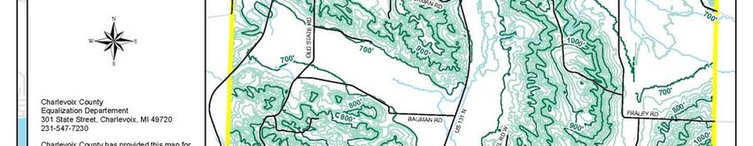
Melrose Township Recreation Plan 2018 – 2022

             Recreational Planning and Administration
                       Melrose Township, 2017

                     Township Board of Trustees
                       Vern Goodwin, Supervisor
                       Robin Hissong Berry, Clerk
                        Shelley Burr, Treasurer
                         Lon Stephens, Trustee
                       Phyllis Cotanche, Trustee

                   Park and Recreation Committee

                          Robin Hissong Berry
                             Broc Johnson
                               Art Tebo
                             Karen Colburn
                          Heather Huffstutler

                                2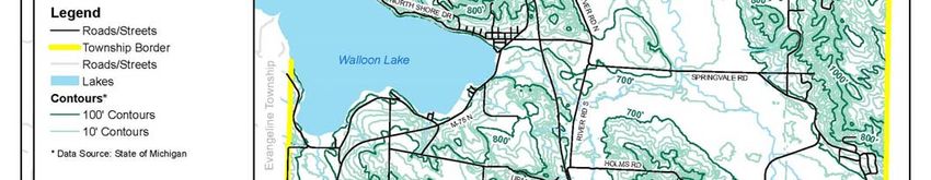
Table of Contents

1.0 Introduction ........................................................................................................................ 4
   1.1 Location ........................................................................................................................................... 6
   1.2 History of Development and Present Day Context .......................................................... 6
2.0 Community Description .............................................................................................. 10
  2.1 Social Characteristics .............................................................................................................. 10
   2.2 Physical Characteristics ......................................................................................................... 19
3.0 Recreation Inventory .................................................................................................. 32
   3.1 Recreation Sites Owned By Melrose Township.............................................................. 32
   3.2 Privately Owned Recreational Sites in Melrose Township ........................................ 37
   3.3 Recreation Sites In Charlevoix County .............................................................................. 39
   3.4 Barrier Free Compliance ........................................................................................................ 56
4.0 Administrative Structure ........................................................................................... 57
   4.1 Township Organization .......................................................................................................... 57
   4.2 Recreation Expenditures ....................................................................................................... 59
   4.3 Organizational Structure ....................................................................................................... 60
   4.4 Relationships with other Agencies ..................................................................................... 60
5.0 Description of Planning Process and Pubic Input Process ............................. 61
   5.1 Planning Process ....................................................................................................................... 61
   5.2 Public Input Process ................................................................................................................ 61
   5.3 Committee Discussions ........................................................................................................... 61
   5.4 Review of Regional and State Activities ............................................................................ 61
   5.5 Goals and Objectives ................................................................................................................ 62
6.0 Action Program and Basis for Action Program ................................................... 66
7.0 Adoption and Transmittals ......................................................................................... 69

                                                                             3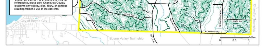
1.0 Introduction
Featured for its natural resources, rural character, and waterways Melrose Township
offers its residents and visitors excellent recreational opportunities. The adopted 1999
Melrose Township Land Use Plan outlined recreational goals to enhance experiences for
both residents and visitors. These include the development of parks and recreation
facilities to provide a variety of recreational opportunities throughout the year. The
development of an updated recreation plan designed in accordance with standards
established by the Michigan Department of Natural Resources (MDNR) enables Melrose
Township to be eligible for grant funding for recreational projects through the MDNR.
These projects empower the township to make progress toward attaining the following
objectives and actions addressed in the 2017 Melrose Township Land Use Plan:
Update the Township Recreation Plan in accordance with the Department of Natural
Resources Requirements
Make full use of State and Federal programs to fulfill the objectives of the plan
Develop Township lands for recreational opportunities
Implement a capital improvements plan for the Township parks plans
Work on implementing the park plan with grant dollars
Consider development of a linked, non-motorized trail system on public lands
Utilize State land for recreational opportunities
Encourage acquisition of additional State land for future recreational use
To become eligible for MDNR funding, a community must have an approved recreation
plan. Components of an MDNR approved recreation plan include:
Community Description: This section describes the social and physical
characteristics of the Township. The social characteristics include age, employment
trends, household sizes, people with disabilities, population, race/ethnic groups, and
gender. Physical elements include a discussion of topography, climate,
transportation systems, soils/vegetation, water resources, fish/wildlife, and land use
patterns and zoning.
4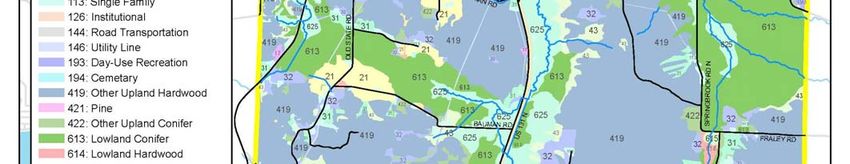
Recreation Inventory: An inventory of existing public facilities, lands, parks, beaches,
access sites, and services available to residents and visitors in Melrose Township.
Administrative Structure: This includes a review of the Township’s operating budget,
organizational chart, standard operational procedures, commission or advisory
board, relationships with other agencies, and description of township staff.
Description of the planning and public input process
Action Program: Development of capital improvements and programs through
outlining short-term objectives. Long-term objectives are addressed though
administrative policy recommendations and initiatives.
Basis for the Action Program: A rationale for the capital improvement projects and
programs addressing the objectives highlighted in the action program.
Plan Review and Adoption: The formal approval process and guidelines are
described as each stage of approval is attained.
5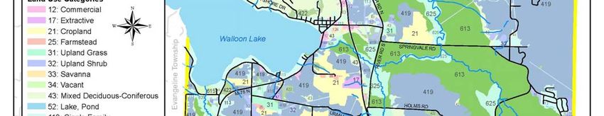
1.1 Location

Map 1-1 exhibits a general location map showing selected political and physical features
of Charlevoix County. Melrose Township is located in the northeast side of the County
located ½ mile East of Boyne City. The township is approximately 33 square miles or
21,075 acres in size. Melrose Township is slightly smaller than a standard congressional
township in total land area due to Walloon Lake meandering through the Northwest
portion of the Township. The northern boundary of the township is the
Emmet/Charlevoix county line, Chandler Township neighbors to the east, Boyne Valley
Township to the south, and Evangeline Township is located to the west. Two primary
highways service Melrose Township. M-75 provides service from Boyne City entering
the township from the southwest and US 131 provides north and south access to
Petoskey and Boyne Falls respectively. A map of the local transportation system is on
page 9 (Map 1-2).

                1.2 History of Development and Present Day Context

Early non-native settlement in Melrose Township began in the mid to late 1800’s along
the waterways serving as primary locations for early development. Attractive natural
resources ushered growth for the region as early settlers established homesteads for
farming and the lumbermen took advantage of the vast timber resource. Settlers
entered the region at a faster rate following the construction of the railroad through the
villages of Walloon Lake and Clarion northward to Petoskey.

With the passage of time, the local economy began to diversify with new residents
recognizing the opportunity to entice travelers and vacationers to the area. Soon,
recreational activities became the featured attraction for the township as it became a
widely recognized resort destination. According to the 2017 Melrose Township Land
Use Plan, as people found greater time for relaxation and recreation, the number of
resorts and second homes grew rapidly. Presently, the growth and development of the
Township is significantly impacted by the availability of recreational options. The
character of the area is best described as a bedroom-resort community. Commercial
and business activities presently are limited but growing slowly. This helps protect
natural resources, however a compromise for some basic services (retail stores such as

                                             6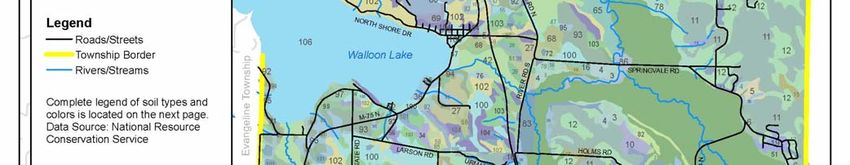
grocery and dry goods) is necessary for those in the Township. This often requires
residents and visitors to travel outside the township to obtain needed services. The
development philosophy of Melrose Township, as detailed in the 1999 Land Use Plan, is
to maintain the rural character of the township and provide a desirable place for people
to live or visit. This would serve to protect the value of the resource base for current and
future generations.

                                             7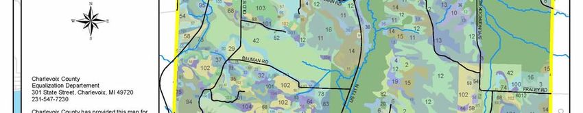
Map 1-1 Location of Melrose Township

                                       8
Map 1-2 Transportation Base Map of Melrose Township

                                     9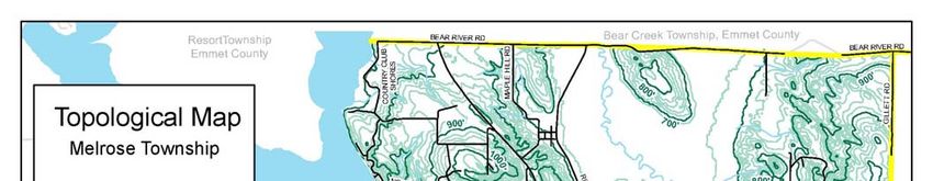
2.0    Community Description

                              2.1    Social Characteristics

An important component in the recreation planning process is an understanding of the
community’s social and economic characteristics. This section explores current and
historical population changes, age distribution, household make-up, income, education,
employment, disability, and housing characteristics for Melrose Township. Where
significant, Township data is compared to Charlevoix County and the State of Michigan.
The purpose of this section is to identify factors that could influence recreation planning
decisions and to assist policy makers with these decisions.

Population

According to the U.S. Census Bureau, the population for Melrose Township in 2010 was
1,403 people with a median age of 48.4 years of age.

                                             10
Table 2-1 compares population trends for the Township and the County for the years
1970 through 2010. The population numbers for 1995, 2000, 2005, and 2010 are
population estimates as forecasted by the Charlevoix County Planning Department.
Table 2-1
Population Trends for Permanent Residents
Melrose Township and Charlevoix County
Year County % Change Township %Change
1970 16,541 ---- 830 ----
1980 19,907 16.9% 947 12.4%
1990 21,468 7.2% 1,106 14.3%
1995 22,350 3.9% 1,160 4.7%
2000 23,580 5.2% 1,240 6.5%
2005 24,390 3.3% 1,275 2.7%
2010 25,500 4.3% 1,320 3.4%
Sources: US Census Bureau (1970-1990)
Charlevoix County Planning Department (1995-2010)
(Estimates are in Italics)
11Seasonal Population
The Census information does not count residents who winter elsewhere. Therefore, in
reviewing the social and economic information derived from the Census data, it is
essential to remember that this data does not fully describe the characteristics of
Melrose Township’s seasonal and visiting population.
Since 2012 Melrose Township has experienced significant commercial redevelopment in
the Village of Walloon Lake. This redevelopment includes a new restaurant, hotel,
coffee shop, retail store, marina, antique store, as well as several year round and
seasonal businesses. These additions have dramatically increased the number of
seasonal visitors to Melrose Township. In 2017 there were 110,000 visitors to the Barrel
Back Restaurant. The increase in seasonal visitors and their impact on the local
economy must be considered in the Park and Recreation planning process.
Age Distribution & Racial Composition
Information on age distribution of a population can assist the community in determining
what, if any, special recreational needs specific resident groups require as exhibited in
Table 2-2
12Table 2-2.
Table 2-2
Age Distribution
Melrose Township - Charlevoix County - State of Michigan
Melrose Township Charlevoix County State
Age Group Population Percent Populatio Percent Percent
n
Under 18 Years 322 29.1% 5,792 27.0% 26.5%
18 - 44 Years 466 42.1% 8,298 38.7% 42.9%
45 - 64 Years 198 17.9% 4,293 20.0% 18.7%
Over 65 Years 120 10.8% 3,085 14.4% 11.9%
Cumulative 1,106 99.9% 21,468 100.1% 100%
Totals
Source: US Bureau of Census
The median age for Melrose Township is 32.1 years, for Charlevoix County it is 34.7,
and for the State is 32.6 years. Note the largest groups are found in the Under 18 and
18 to 44 year bracket for the Township. The age composition of township residents is
important for policy makers to understand when evaluating the recreational needs of the
residents. A younger population may prefer active recreational activities including
Nordic skiing, hiking, mountain biking, and sporting events (like volleyball and
basketball).
13The Township is ethnically/racially homogenous in nature with 98.6% of the population
classified as White with the remaining 1.4% being composed of 9 Native Americans, 5
Hispanic persons, and 1 classed as “Other”. These percentages are very similar to
those representing the entire County.
Disability Status
In order to track disability statistics, the U.S. Census breaks the population into two
different age categories: working age and post-working age. Of the civilian non-
institutionalized population in the 16-64 years age group in Melrose Township during
2010, 4.5% are listed as having a disability that prevents them from working.
Additionally, nearly 3% indicated they have a mobility or self-care limitation.
Township residents 65 years and older were also surveyed and the results show that
10.7% of the group has a mobility or self-care limitation. In comparison, both the County
and the State were higher at 16.0% and 20.2% respectively for the same age class.
Education
Education is an important factor in analyzing the capabilities of the local work force and
the economic vitality of a community. The U.S. Census Bureau tracks educational
attainment. Statistics from the 2010 Census exhibit that 94.1% of Melrose Township
residents have at least a high school diploma or GED, as compared to 79.7% for
Charlevoix County and 76.8% for the State as a whole.
Township residents with a bachelor’s degree or higher amount to 15.5% of the adult
population, while Charlevoix County and State of Michigan have 16.0% and 17.4%
percent college graduates, respectively.
14Income and Employment
Three measures of income (median household, median family, and per capita) are
illustrated in Table 2-3 (on the following page) for the Township, County, and State.
Income statistics for the 2010 census reflect information from the 2010 calendar years.
The median income for Melrose Township residents is higher than that of the County,
but lower than the State. The table also illustrates poverty statistics comparing Melrose
Township to other units of government. The poverty threshold for the 2010 Census was
set at $12,674 for a family of four. At 5.5%, the poverty rate for all persons in Melrose
Township is less than that of the County at 7.3% and the State at 10.2%.
Table 2-3
Income Statistics
Melrose Township, Charlevoix County and The State of Michigan
Median Household Income Per Capita Income
2010 2000 1990 2010 2000 1990
Melrose Township $51,667 $25,297
Charlevoix County $47,177 $39,788 $27,487
State of Michigan $48,669 $ 44,667 $40,260 $25,482 $ 22,168 $18,370
Source: American Community Survey/ U.S. Census Bureau
15Another method of describing the economic characteristics of a community is to analyze
the employment by occupations. A comparison of occupational employment for the
Township, County and the State is presented in Table 2-4.
Table 2-4
Employment (by Occupation)
Melrose Township, Charlevoix County and State of Michigan - 2010
Melrose Township Charlevoix State
Occupation
County
# % # % %
Management, professional, and related
123 21.2 3,440 29.2 33.6
occupations
Sales and office occupations 153 26.4 2,913 24.7 25.1
Service occupations 120 20.7 2,036 17.2 18.0
Construction natural resources, and
96 16.5 1,405 11.9 8.3
maintenance occupations
Production, transportation, and material
88 15.2 2,012 17.0 15.0
moving
Total 580 100.0 11,806 100.0 100.0
Source: American Community Survey/U.S. Census Bureau.
16Households
Data from the 2010 Census shows that Melrose Township has an average a greater
household size of 2.79 persons per household, as compared to 2.59 persons per
household for Charlevoix County, and 2.66 persons for the State.
Table 2-5 compares the household characteristics of Melrose Township with that of
Charlevoix County, State of Michigan, and the United States. The Township has a
significantly greater proportion of married couples than the other three geographic units,
and fewer single person non-family households.
The 2010 Census reported that 1,397 people resided in households, and 6 lived in group
quarters. 176 households had individuals under 18 years, while 149 Households had
individuals 65 and over. The 2010 breakdown is as follows:
Relationship # Percent of
Households
Population In Households 1397 99.6%
Householder 540 38.7%
Spouse 309 29.4%
Child 411 22.3%
Own child under 18 268 16.7%
Other Relatives 74 5.3%
Under 18 years 34 2.4%
65 years and older 10 0.7%
Non Relatives 63 4.5%
Unmarried partner 31 2.2%
In Group Quarters 6 0.4%
17Table 2-5 (cont’d)
Total Number of Households: 540 {housing that was occupied on April 1, 2010}
Family Households: 384 71.1%
Nonfamily Households: 156 28.9%
Average Household size: 2.59
Average Family size: 3.07
Total Number of Housing Units: 935
Occupied Housing Units: 540 57.8%
Owner-occupied 461 85.4%
Renter-occupied 79 14.6%
Vacant Housing Units: 395 42.2%
For rent: 20 5.1% of vacant
For Sale Only: 21 5.3% of vacant
For seasonal, recreational
Or occasional use: 322 81.5% of vacant
All other vacant housing: 32 8.1%
182.2 Physical Characteristics
An analysis of Melrose Township’s physical environment and existing land use can
assist government officials in planning for future recreational facilities and activities. The
preservation, protection, and enhancement of the natural features within the Township
have been identified as a central goal in the Township’s 2017 Land Use Plan. To
achieve this the Township is committed to achieving the following objectives:
Encouraging the preservation of areas providing high quality fish and wildlife habitats
Encouraging the use of proper management techniques throughout the State forest
lands in the Township
Encouraging high quality design standards for both public improvements and private
developments to ensure compatibility with the natural surroundings
Providing for the preservation of scenic sites
Discouraging development in areas designated as unsuitable such as steep slopes,
flood plains, wetlands, and poor soils.
Inventorying, mapping, and protecting the significant natural features (wetlands,
slopes, wooded areas, scenic views, lake, and streams) in the Township
Designating features important to the Township to protect them from over
development
Working with the Gaylord Management Unit to help determine the future of the State
owned public lands in the Township
Continuing to work with the Walloon Lake Association, Tip of the Mitt Watershed
Council, and Walloon Lake Trust and Conservancy to maintain and improve the
water quality of Walloon Lake.
Physical characteristics addressed in this report include existing land use and zoning,
topography, water resources, fish and wildlife, soils and vegetation, transportation
systems, and climate.
19Existing Land Use Patterns and Zoning
The relationship between existing park and recreation facilities and other land uses in
the community is critical in determining the location of future recreational facilities. This
enables decision makers to recognize areas where future growth is anticipated and/or
further expansion of existing facilities may be necessary. This also identifies areas
where existing recreational facilities may be insufficient for the recreational needs of
Township residents and visitors.
Map 2-1 exhibits the Land Use Map Township’s Land Use Plan. This figure represents
the existing land uses in the Township.
20Agricultural/Vacant Lands
This category includes the forested, open/shrub land, and agricultural classes on the
land use map. Presently just over one-third of the Township is either vacant or used for
agricultural and/or forestry. Approximately half of this land is semi-suited for some type
of farming industry, being flat with partially open fields. The other half is more
constrained due to steep slopes, wetlands, poor soils and the lack of available
infrastructure.
Residential
Lake residential is located along the shores of Walloon Lake. The lakeshore is primarily
developed, with some limited parcels still available for future splits and development.
Medium density residential development exists in several areas of the Township
including Springbrook Hills, the Village of Clarion, along North Shore Drive opposite the
lake, along Addis Road in the Southwest corner of the Township, and in the vicinity of
the Village of Walloon Lake. A majority of these are platted developed lots. A majority
of the current rural agricultural residential structures are located on fronting parcels and
built directly with access to primary highways and County roads throughout the
Township. Affordable housing and senior housing are the greatest housing needs
currently existing for Melrose Township.
Commercial/Industrial
There are several commercial businesses located in the Township that include two full
service restaurants, a realty company, an interior design studio, Walloon General Store,
full-service marinas (with boat rental), two boat service and sales companies, antique
shops, the offices of the Walloon Lake Trust and Conservancy/Walloon Lake
Association, an event center, and a substance abuse recovery center. There are also
several seasonal retail businesses that include novelties, jewelry, home accessories,
and unique foods products.
21Public Lands
One-third of the township is owned by the State of Michigan and managed under the
Gaylord Forest Management Unit. There are trails for snowmobiles, bikes, cross-
country skiing, hunting, and hiking including the Bear Hill trail on the north shore of the
Bear River. Currently there are no designated campground areas in the State Forest
areas. The Township owns approximately 180 acres of land. Most of the land is not
suitable for high intensity activity since most is highly wooded, steeply sloped, or marsh
areas. The Township has one public park on Walloon Lake in the Village of Walloon that
extends from the lakefront, across M-75 to the east with a trail system. The park offers
public recreational uses such as sunbathing, swimming, a play area, picnic areas,
gazebo and restroom facilities. Additional public land, named Bear Hill Trail on North
Shore Drive offers a small parking area and hiking trail connecting to lands managed by
the Walloon Lake Trust and Conservancy. The Township also owns and maintains a
public boat launch on Walloon Lake. Other lands include the Township Hall and Fire
station located just west of the M-75 and US 131 intersection, and the Township
Cemetery Northwest of Clarion along Maple Hill Road. Please reference the
Recreational Site Inventory Map in Section 3.0 for other Township lands that are
currently undeveloped.
Zoning
Zoning is another factor that needs to be considered in determining the location for
expansion of existing and development of new recreational facilities. Zoning is a locally
adopted ordinance which delineates the municipality into districts within which uniform
regulations and requirements govern the use, placement, spacing, and size of land and
buildings. The Township contains ten zoning districts. Four districts relate to residential
use, three for commercial use, and one for industrial, agricultural, and forest reserve.
22Topography
The Township and all of Northern Michigan was subjected to glacial ice sheet advances
and retreats 10,000 – 12,000 years ago which greatly influenced the relief of the land.
The glacial action had a large impact on the formation of the parent material or
unconsolidated mass in which soils were formed.
The relief of the land in the Township ranges from flat, post-glacial lake melt-water plains
(existing as wetland and lowland areas currently) to very steep slopes (25% – 50% in
some locations). Map 2-2 contours display 10’ intervals and high points at 100’ intervals.
Elevations range from 639 feet in the Southwest corner of the Township to 1,100 feet in
the Northeast corner of the township.
23Map 2-2 Topographic Map
24Map 2-3 Water Resources and Wetlands
25Water & Wildlife Resources
Walloon Lake is the primary water resource attraction and is partially located in the
Northwestern section of the Township. There is a high density of residential
development around the lake. Approximately 99% of the shoreline in the Township is
privately owned with limited public use. Walloon Lake existed in pre-glacial times as a
river valley. The lake is surrounded by hilly and rolling terrain that can rise as much as
200 feet above water level. Walloon Lake is the 21st largest lake in Michigan with a
mean depth of 28.9 feet and a maximum depth of approximately 100 feet. The lake
extends into four other Townships, as well as Emmet County.
Walloon Lake is fed primarily by groundwater springs and a few inlet creeks. Walloon
Lake has a low flush rate and all land use that takes place in the watershed should be
monitored. The Bear River begins at the outfall of Walloon Lake, at the east end of the
lake. It begins flowing to the east and then turns abruptly north two miles east of the
Village of Walloon Lake. It then winds northward through into Emmet County eventually
reaching Little Traverse Bay and Lake Michigan in the City of Petoskey 90 feet lower
than Walloon Lake.
There are several other creeks and streams in the Township that feed into the lake or
into the river itself. These offer limited public use because of their size, but they do
provide vegetation and habitat for wildlife. Water activities are a well-known recreational
attraction, in the Township, including swimming, boating, and sport fishing in the summer
months, and ice fishing in the winter months. Walloon Lake is and should remain
protected as a natural resource as well as an attraction.
Three future goals were dedicated to protecting the natural and scenic resources of the
Township as indicated in the Melrose Township Master Plan adopted in 2015 by the
Township Planning Commission.
Protection of rivers, Walloon Lake, and streams from pollution or future
infringements
To work with the Michigan Department of Natural Resources to pursue efforts of
protecting lands under their jurisdiction but located within the Township
Limiting high impact activities within State Forest areas
26Soils and Vegetation
Soil characteristics help to define the land capacity to support certain types of land uses.
Soils most suitable for development purposes are well-drained and are not subject to a
high water table. Adequate drainage is important to minimizing storm water impacts and
the efficient operation of septic drain fields. Adequate depth to the water table is
necessary to prevent groundwater contamination from septic systems. A high water
table also limits the construction of basements. Though civil engineering techniques can
be employed to improve drainage and maintain adequate separation from the water
table, such techniques are expensive to construct and maintain. Planners and public
officials should carefully consider any development proposal which threatens this
nonrenewable resource.
Wetland soil types (hydric) are generally unsuited for septic system installations, road
construction, and building site development. These soils tend to be of insufficient
strength to support building foundations. Shrinking and swelling of soils during
freeze/thaw cycles can damage building foundations unless soils are modified with the
appropriate fill materials. There are several areas of the Township where these soils
occur, primarily adjacent to the Bear River and around the various streams and creeks.
Areas noted as Hydric Inclusions are generally poorly or somewhat poorly drained soils
which means these soils tend to be wet for significant periods of time but not
continuously. Development in these areas should be reviewed on a site-specific basis.
A thorough investigation should be made to determine the soil’s ability to provide
necessary drainage for on-site septic systems and support for foundations as
determined by the ponding frequency of the soil. Upland soils tend have qualities
suitable for most types of developments. The primary consideration when developing
areas with Upland Soils is the slope gradient, which is a notable concern for the
Township.
27Map 2-4 Soils
28Map 2-4 Soils Legend
29Transportation Systems
The principal purpose of local roads is to provide access to property abutting the public
right-of-way. County roads conduct traffic from local streets to primary highways, which
are designed to move large volumes of traffic. Parking on primary highways is one
function that should be increasingly controlled due to the increased traffic pressures.
Presently two primary highways service the Township, M-75 N and US-131. Bear River
Road, River Road, Springvale Road, North Shore Drive, South Shore Drive, Country
Club Road, and Shadow Trail are County Primary roads while all others are considered
local roads or unimproved roads. Refer to the transportation base map (Map 1-2) in the
Introduction for the routes described.
Climate
The climate in Melrose Township is greatly influenced by Lake Michigan, which tends to
moderate temperatures during the year by keeping them slightly warmer in the autumn
and cooler in the spring. This is in contrast to areas further inland in Northern Michigan.
30Table 2-6
Melrose Township Climate Summary
East Jordan Station
Temperature Summary
January Average Minimum Temperature 12.2ºF
January Average Maximum Temperature 28.4ºF
July Average Minimum Temperature 54.5ºF
July Average Maximum Temperature 81.2ºF
Precipitation Summary
Average Annual Rainfall 31.59”
Average Annual Snowfall 99.9”
Growing Season Summary
Date of Last Spring Occurrence3.0 Recreation Inventory
An inventory of existing recreational facilities located in Melrose Township and
surrounding area are grouped according to jurisdictional ownership, followed by a brief
description of each site. Map 3-1 (refer to the following page) illustrates recreational
sites within the Township boundaries including State and Township lands.
3.1 Recreation Sites Owned By Melrose Township
Melrose Township owns the following properties, which are currently being used for
recreational purposes or could potentially be used for recreational purposes. The
Township owns approximately 130 acres of land (not including road ends), which could
serve for future site development.
Melrose Township Park
The Township Park is accessed from M-75 just south of the Village of Walloon Lake.
The park is approximately 22 acres with four acres developed to offer a variety of day
use activities. It is open to the pubic year round from dawn to dusk. Currently, the park
has no organized club activities or leagues. Future park facilities should include more
team sport opportunities as outlined in the future recreation goals. Amenities at the site
include:
Picnic Pavilion/Gazebo
Outdoor grills, picnic tables, and benches throughout
Public sandy beach along Walloon Lake
Paved Basketball Full-Court
Public Restroom Building
“Veterans Who Served in WWII” monument
“Veterans Buried at Maple Hill Cemetery” monument
Tot Lot (Balance Beam, Merry-Go-Round, Slides, Swing Sets, Jungle Gym)
Bear River frontage
22-acres of undeveloped open and natural area
Trail system through undeveloped area
Afton Stone Parking Area for Approximately 40 Vehicles
Pickle Ball court
Hemingway historical marker
32The beach area of the Melrose Township Park is located directly across M-75N from the
main parking area. The combined usage at the park and beach exceeds 300 people on
many summer days. The beach area in particular offers the following amenities:
600 Feet of frontage on Walloon Lake (Approx. 150 feet sandy)
Swimming area defined with buoys up to a 6-8 ft. depth
Both grass and sandy beach areas regularly maintained for users
Southern-most area of waterfront near the Bear River outfall provides benches
for lake viewing and enjoyment of the head of the Bear River
Multiple benches for sunset and lake viewing
Melrose Township Boat Launch, Walloon Lake
Recreational boat access on Walloon Lake is a popular facility for residents, cottage
dock maintenance businesses, visitors and guests in the Township. It is the only public
launching access in the township on Walloon Lake. The launch site was completely
reconstructed in 2011 and can easily accommodate boats up to 20’ in length and has a
ramp and dock. A paved parking facility on M-75 was also completed in 2011, which
can accommodate up to 16 vehicles with trailers. The facility also has an accessible rest
room.
Melrose Township Hall & Fire Station
The Township Hall serves the dual purpose of providing the Township’s offices and
training room for the Township Volunteer Fire Department. All Township meetings are
held in the Hall as well. A garage housing the Township’s firefighting apparatus is
attached to the hall. A paved parking area is present along the west side of the building.
The township building offers public meeting space and accessible public restrooms.
33Undeveloped Township Lands
The township has four separate properties that may serve future recreational desires.
Each will be described in terms of its location, acreage, and development constraints to
buildings and equipment. Some of these lands serve as excellent wetland areas for
wildlife habitat and viewing.
Section 7: Located primarily along the east side of North Shore Rd (with some land
located on the west of this road in the northwest side of the Township), this 31-acre
property is characterized as being on upland soils and rolling hills/slopes.
Developed parking and Bear Hill hiking trail includes shared access to Walloon
Lake Trust and Conservancy’s North Shore Preserve.
Section 8: The 17-acre property is located in the southeast portion of Section 8. It
contains upland soils and is on rolling hills/slopes with an 18%-25% grade.
Section 9: This 7-acre property is located along the west side of State Road just
north of Walloon Lake Village. Slopes on this site are rolling with up to a 25%
grade and the soils are mostly upland with the exception of the northeast corner
which is poorly drained (hydric). This section is currently being used as the
Transfer Station/recycling area.
Section 16: This 40-acre property is undeveloped in the north-central part of the
section. The property’s soils are mostly hydric – this parcel contains wetlands,
floodplain, and the Bear River. The slopes of the site tend to be flat to gently
rolling. Five acres of this property are now developed as a municipal drain field
system.
34Map 3-1 Melrose Township Recreation Inventory
35Map 3-1 Melrose Township Recreation Inventory Legend
363.2 Privately Owned Recreational Sites in Melrose Township
Challenge Mountain
Challenge Mountain of Walloon Hills is recreational facility designed for physically and
mentally impaired people. The Mountain hosts a Winter Special Olympics on a ski hill
where youth are presented with a chance to compete, demonstrate, and be recognized
for their talents. The location has two rope tows designed to accommodate special
needs children. Facilities also include a lodge with a kitchen, restroom area, and eating
area. In the summer, horseback riding is the primary activity at the site. Considerations
for future activities may include snowmobile and mountain-bike trails. The location is
open to families with special needs children or those working with these children.
Walloon Lake Country Club (Private)
The Walloon Lake Country Club is located in the northwest part of the Township
encompassing an area of about 112 acres. Located on Country Club Road, this site is
restricted to members and their guests. This 18 hole course is generally open from late
spring to early fall. A significant number of Township residents are members. It is
directly north of the Walloon Lake Trust and Conservancy’s Postle Farm Preserve and
Asa Wilson Preserve.
Springbrook Hills Subdivision
The Springbrook Hills Subdivision provides a recreational opportunities for residents
(and guests) of the subdivision. The attractions include a clubhouse, swimming pool,
and fishing pond. Cross-country skiing is available during the winter as well.
Springbrook Hills Golf Course
Located east of the residential area of the subdivision is an 18-hole course in both
Melrose and Chandler Townships. The course is open to the public and offers amenities
including a clubhouse and restaurant.
Flywheelers Club
The Walloon Lake Flywheelers Club is a nonprofit organization that maintains and
operates over 100-acres of land to showcase antique equipment and tractors and an
37“old fashioned way of doing things.” They host an annual Flywheelers Show each
summer that brings thousands of visitors to our community. They also host several other
events each year, including field trips for school-aged children from across the area.
Walloon Equestrian Center
The Equestrian Center is located on Old State Rd, and provides riding and boarding
services including an indoor arena for year-round accommodation. They have riding
trails on-site that connect to State of Michigan trails for long-ride opportunities.
Elvyn Lea Lodge
Elvyn Lea Lodge is a private events facility on 40-acres of gently rolling hills along the
southern shore of Walloon Lake. Elvyn Lea hosts special events, and provides lodging
for groups and individuals visiting the area’s recreational opportunities.
Walloon Lake Trust and Conservancy Preserves
The Walloon Lake Trust and Conservancy owns and manages the following preserves in
Melrose Township open to the public:
North Shore Preserve, 53-acres of steep slopes and wooded land with a loop trail
and parking area in partnership with Melrose Township.
Postle Farm Preserve, 113-acres of open field, historic farmstead, and wooded
land with 3-miles of trails, parking for 15 vehicles, and space for public events.
Asa Wilson Preserve, 45-acres of wooded land adjacent to Postle Farm Preserve
on Country Club Road
Country Club Shores Preserve, 15-acres of wooded land close to the Walloon
Lake Country Club along Country Club Road
Cedar Valley Preserve, 50-acres of wooded land along South Arm Creek,
protecting hilly woodlands, wetlands, and stream corridor. Parking for 10 vehicles
and a 1.5 mile loop trail are available
Frog Hollow Preserve, 65-acres of cedar wetlands protecting South Arm Creek.
Preserve is open for hunting, but no other amenities are developed
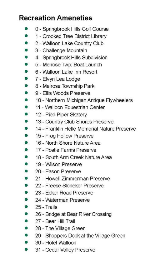
Other preserves open to the public but not developed include Shadow Trail
Nature Area (2 preserves along Shadow Trail Rd), Hargreaves-Matthews
Preserve, Freese-Sloneker Preserve and Howell-Zimmerman Preserve on South
Shore Drive, and Ecker Road Preserve along M-75 North at Ecker Road.
383.3 Public Recreation Sites in Charlevoix County
State of Michigan Recreation Sites
The Michigan Department of Natural Resources owns over 8,000 acres of land in
Melrose Township which is part of the Mackinaw State Forest. State forest lands
provide excellent recreational opportunities for low impact uses including hiking, hunting,
wildlife viewing, and mountain biking and camping. Currently there are no designated
pathways or rustic campgrounds administered by the State of Michigan in Melrose
Township. However, there are several two-track trails throughout the forest serving as
undesignated pathways for hiking and mountain biking. Virtually all state forest land is
accessible for camping, provided a permit is obtained from a DNR field office.
The only designated pathway in Charlevoix County administered by the MDNR is the
Spring Brook Pathway located in the southwest quarter of Chandler Township
(approximately 2.5 miles east of Melrose Township). The pathway offers five miles of
trails situated on flat to hilly terrain, for Nordic skiing, hiking, hunting and snowmobile
trail.
Young State Park is located four miles east of Melrose Township, just northwest of
Boyne City. The park offers 563 acres of land for modern camping, day use facilities,
and year-round recreational activities. The park offers boating access to Lake
Charlevoix and Lake Michigan from a launch site with a paved ramp which can
accommodate most recreational watercraft. The park offers 240 campsites and is
designated as a handicapped accessible facility. The day use area contains a picnic
area, swimming beach, beach house, concession, and playground. Activities within the
park include interpretive programs, fishing, hiking, and Nordic skiing. The park is located
on Boyne City Road in Evangeline Township.
Fisherman’s Island State Park is located about 20 miles west of Melrose Township and
is 2 miles southwest of the City of Charlevoix. This park offers over 2600 acres of land
area featuring a large, 90 site rustic campground, scenic hiking areas, and five miles of
undeveloped Lake Michigan shoreline. The park has a day use area for swimming,
hiking, and fishing.
39County-owned recreational sites
The Charlevoix County Recreation Plan adopted in 1998 was consulted to review
current facilities and recreation improvements available to all County residents, including
Melrose Township. The Plan describes three primary sites where the County is both the
owner and is responsible for the maintenance of these locations. The recreation plan
was prepared by the County to serve as the local recreation plan for many communities
in the County as well. The Plan acknowledges that the sites described serve more than
just the local community in which the facility is located. Therefore a coordinated effort on
the part of the cities, villages, townships, county, and state governments is encouraged
to benefit the interests of everyone and foster cooperation between all units of
government.
Whiting Park
Whiting Park continues to experience an increase in usage during the spring, summer,
and fall months. It has an area of 118 acres in Eveline Township that was donated to
the County for use as a county park, by Perry Whiting in 1923. The park is bisected by
Ferry Road. The lakeshore parcels contains 48 campsites, a swimming beach, boat
launch and dock capable of handling shallow-draft boats, a toilet-shower building, and a
parking area for day use. The majority of the property is located on the west side of
Ferry Road and offers a ballfield, picnic facilities, two community buildings, and two open
air pavilions. The park is approximately 8 miles west of Melrose Township located four
miles northwest of Boyne City along the southwestern shore of Lake Charlevoix.
Thumb Lake Park
Thumb Lake Park is approximately 10 acres of land on the east end of Thumb Lake
which was acquired in 1993. It is located in Hudson Township, six miles southeast of
Melrose Township. The park includes over 1500 feet of frontage on Thumb Lake. This
is a popular swimming beach used by residents and visitors of the eastern third of
Charlevoix County. Minimal improvements have been made to the park since its
acquisition, which includes the development of a parking area and installation portable
toilet facilities. The property is bisected by Magee Road, with the parking area and
toilets on the East side of the road, and the beach area on the West side of the road.
40Porter Creek Natural Area
In 1996, the Michigan Department of Natural Resources transferred the ownership of
100 acres of land in Wilson Township to Charlevoix County. In 1997 the County
assumed ownership and the land became known as the Porter Creek Natural Area,
located along Porter Creek and is characterized by a mixture of wetlands and wooded
uplands. The undeveloped park can be accessed from Snyder Road and is located two
miles West of Boyne City or about five miles west-southwest of Melrose Township. The
Natural Area boasts a 1.2 mile trail loop through special natural features of Charlevoix
County.
Other nearby recreation sites
Boyne City
Boyne City’s water resources are the focal point of its park system and require careful
planning and implementation for proper development. These significant water features
include City land holdings providing 3,000 feet of frontage on Lake Charlevoix and the
Boyne River flowing through the center of the City. The City’s Sunset and Veterans
Parks are in the central section of the City, along the shores of Lake Charlevoix,
adjacent to the Central Business District, and the public multi-use dock in Sunset Park.
The City’s Municipal Marina is also located in Veterans Park. The Boyne River flows
through the City’s business district, and empties into Lake Charlevoix at the point where
Sunset and Veterans Parks meet. Avalanche Preserve is at the southern boundary of
the city. This 320 acre complex will be a focus for long-term improvements in City parks.
41Table 3-1 is a summary of the existing recreation facilities in Boyne City as presented in
the 2009 Charlevoix County Recreation Plan.
Table 3-1
City of Boyne City
Existing Recreation Facilities
Facility Name Ownership Open to Approximate Facilities Available
Public Size
NORTH LAKE CHILDREN'S
STREET (MOLL) PLAY
PARK CITY YES 1/2 ACRE EQUIPMENT
REST ROOMS,
MULTI-USE
DOCK, FISHING,
SUNSET PARK CITY YES 5 ACRES BOATING
CROSS-
COUNTRY SKI
TRAIL, HIKING
TRAILS, SHELTER
HOUSE, REST
ROOM, NATURE
PRESERVE,
SLEDDING HILL,
LIGHTED ICE
SKATING,
STAIRWAY TO
SUMMIT VIEWING
DECKS,
SNOWMOBILE
TRAIL, DISK
AVALANCHE GOLF, ARCHERY
PRESERVE CITY YES 320 ACRES RANGE
ACCESS SITE ON
LAKE BOAT LAUNCH,
CHARLEVOIX CITY YES 1 ACRE REST ROOMS
TENNIS COURTS,
PICNIC SITES,
CHILDREN'S
PLAY
EQUIPMENT,
NATURE STUDY
ROTARY PARK CITY YES 40 ACRES
TRAILS, LIGHTED
42BALL DIAMONDS,
RESTROOMS
BOATING, PICNIC
SITES,
CHILDREN'S
PLAY
EQUIPMENT,
FISHING, BALL
DIAMONDS,
BENCHES,
RESTROOMS,
VETERANS 10.5 SMALL BOAT
MEMORIAL PARK CITY YES ACRES LAUNCH
PICNIC SITES,
BENCHES,
FISHING,
GAZEBO,
CONCERTS,
FARMERS
OLD CITY PARK CITY YES 1.0 ACRES MARKET
PLAYFIELDS,
BASKETBALL
COURTS,
CHILDREN'S
PLAY
EQUIPMENT,
MEETING
ROOMS,
GYMNASIUM,
BOYNE CITY KITCHEN, ALL
ELEMENTARY LIMITED PURPOSE ROOM,
SCHOOL SCHOOL HOURS 1/2 ACRE LIBRARY
BASKETBALL
COURTS,
CHILDREN'S
BOYNE CITY LIMITED PLAYGROUND,
MIDDLE SCHOOL SCHOOL HOURS 1/2 ACRE INDOOR GYM
PLAYFIELDS,
ORGANIZED
SPORTS FIELD,
BALL DIAMONDS,
MEETING ROOM,
BOYNE CITY HIGH LIMITED
GYMNASIUM,
SCHOOL SCHOOL HOURS 20 ACRES
KITCHEN, ALL
43PURPOSE ROOM,
WEIGHT ROOM,
LIBRARY
SWIMMING,
VOLLEYBALL
COURTS, REST
ROOMS, PICNIC
SITES,
PENINSULA CHILDRENS TOT
BEACH CITY YES 12 ACRES LOT, BENCHES
FISHING, CANOE
RIVERSIDE PARK CITY YES 5 ACRE LAUNCH
LIMITED MEETING ROOM,
CITY HALL CITY HOURS MUSEUM
BOYNE DISTRICT LIBRARY,
LIBRARY CITY YES N/A MEETING ROOM
PICNIC AREA,
SUNSET VIEW,
TANNERY PARK CITY YES 0.5 ACRES SWIMMING
T-BALL / MINOR
LEAGUE 1 3/4 BALLFIELD &
BALLFIELDS CITY YES ACRES RESTROOMS
49 BOAT SLIPS,
PICNIC AREA,
BOYNE CITY MEMBERS BATH HOUSE,
MARINA CITY / RENTAL 0.5 ACRES LIGHTHOUSE
WOODLAND WATER ACCESS
STREET ROAD (NOT BARRIER
END CITY YES 0.25 ACRE FREE)
WATER ACCESS
SHADY LANE (NOT BARRIER
ROAD END CITY YES 0.25 ACRE FREE)
BAY STREET WATER ACCESS
ROAD END (NOT BARRIER
(WEST) CITY YES 0.25 ACRE FREE)
WATER ACCESS
JOHN STREET (NOT BARRIER
ROAD END CITY YES 0.25 ACRE FREE)
44CHARLEVOIX BARRIER FREE
STREET ROAD VIEWING
END CITY YES 0.25 ACRE PLATFORM
LOWER LAKE WATER ACCESS
STREET ROAD (NOT BARRIER
END CITY YES 0.25 ACRE FREE)
SOUTH LAKE AND
CHERRY MINI OPEN SPACE
PARK CITY YES 0.5 ACRE (BARRIER FREE)
OPEN SPACE
WEST AND WITH PICNIC
PLEASANT MINI TABLE (BARRIER
PARK CITY YES 0.5 ACRE FREE)
BIKE/PEDESTRIAN PAVED PATH
PATH CITY YES 3 MILES (BARRIER FREE)
Chandler Township
Chandler Township is adjacent to the east side of Melrose Township. While Chandler
does not offer a large number of organized recreation facilities, the Township does
contain about 16,190 acres of state land. This undeveloped, forested land provides the
regional area with recreational activities including hiking, cross country skiing, and
hunting. Table 3-2 on the following page indicates the existing recreational facilities in
the Township as indicated in the 2017 Charlevoix County Recreation Plan.
45Table 3-2
Chandler Township
Existing Recreation Facilities
Facility Name Ownership Open to Approximate Facilities
Public Size Available
16,190
STATE FOREST STATE YES ACRES NONE
CROSS
COUNTRY SKI
NORTH COUNTRY AND HIKING
TRAIL STATE YES TRAILS
HIKING &
CROSS
SPRINGBROOK COUNTRY SKI
PATHWAY MIXED YES 5 MILES TRAILS
MEETING
CHANDLER LIMITED ROOM,
TOWNSHIP HALL TOWNSHIP HOURS N/A KITCHEN
SPRINGBROOK
HILLS GOLF
COURSE PRIVATE YES 600 ACRES GOLF COURSE
LIMITED MEETING
FIRE STATION TOWNSHIP ACCESS N/A ROOM
CAMPSITES,
CHANDLER HILL SWIMMING
CAMPGROUND PRIVATE YES 20 ACRES POOL
SNOWMOBILE
TRAILS (NEAR MIXED
SLASHING RD) (DNR) YES TRAIL 76 & 765
MCCCT (ALONG
SLASHING &
CHANDLER HILL
RD) MIXED YES DIRT BIKES
MCCCT (ALONG
GREAT LAKES RD) DIRT BIKES
46Hudson Township
Hudson Township is located southeast of Melrose Township and is located the
southeast corner of Charlevoix County. This rural township lacks any towns or villages
which limits the amount of available funds for recreational facilities. The Township has
very limited active, outdoor recreational facilities but is rich in its natural resource base.
Over 3400 acres of state land within the Township belongs to the Mackinaw State
Forest.
Table 3-3
Hudson Township
Existing Recreation Facilities
Facility Name Ownership Open to Approximate Facilities Available
Public Size
STATE 3,427
FOREST STATE YES ACRES NONE
THUMB LAKE SWIMMING,
PARK COUNTY YES 10 ACRES TOILETS
ACCESS SITE
ON THUMB PRIVATE;
LAKE (WEST LEASED TO
END) THE STATE YES BOAT LAUNCH
HUFFMAN SWIMMING,
LAKE PICNIC SITES W/
TOWNSHIP PAVILLION, BOAT
PARK TOWNSHIP YES 3.8 ACRES LAUNCH
MEETING ROOMS,
ALL PURPOSE
ROOM,
CHILDREN’S PLAY
HUDSON AREA, PAVILLION,
TOWNSHIP LIMITED AND BASKETBALL
HALL TOWNSHIP HOURS N/A COURT
ACCESS SITE
ON BOWS
LAKE TOWNSHIP YES ½ ACRE BOAT LAUNCH
CAMP NON- MEMBERS
SWIMMING, BALL
KINAWIND PROFIT & GUESTS
DIAMONDS,
47PLAYFIELDS,
BOATING
POOL, CABINS,
SWIMMING,
ACROPOLIS BOATING,
RESORT PRIVATE FISHING
BALL DIAMONDS,
SWIMMING,
VOLLEYBALL
COURTS,
PLAYFIELDS,
BOATING,
LAKE LOUISE ARCHERY, ALL
METHODIST NON- MEMBERS/ PURPOSE ROOM,
CAMP PROFIT GUESTS KITCHEN
BALL DIAMONDS,
SWIMMING,
VOLLEYBALL
COURTS,
PLAYFIELDS,
BOATING,
LAKE LOUISE ARCHERY, ALL
BAPTIST NON- MEMBERS/ PURPOSE ROOM,
CAMP PROFIT GUESTS KITCHEN
STOCK CAR
RACE TRACK PRIVATE YES RACING
48Boyne Valley Township
Boyne Valley contains one of the premier ski resorts in the Midwestern United States,
Boyne Mountain. As a result, it draws a substantial number of visitors into the area
during the winter months for skiing and during the summer months for tennis and golfing
activities. This is a private facility and therefore is not subject to the same access and
availability as would be public facilities. According to the 1998 Charlevoix County
Recreation Plan, the Village of Boyne Falls and Boyne Valley Township currently have
insufficient recreational facilities necessary to serve the 1100 residents living in both
municipalities. Over 4300 acres of Mackinaw State Forest lands are available for
residents and visitors to explore within the Township.
Table 3-4
Boyne Valley Township
Existing Recreation Facilities
Facility Name Ownership Open to Approximate Facilities Available
Public Size
STATE 4370
FOREST STATE YES ACRES NONE
LAKE 1 ACRE –
ACCESS SITE 1400 FEET PARK, BOAT
ON DEER OF LAUNCH,
LAKE STATE YES FRONTAGE SWIMMING
ROADSIDE
PARK ON U.S.
131 STATE YES PICNIC TABLES
MEETING ROOM,
GYMNASIUM,
KITCHEN, ALL-
PURPOSE ROOM,
PLAYFIELDS,
CHAR-EM ISD CHILDREN'S PLAY
/ EQUIPMENT,
ALTERNATIVE LIMITED BASKETBALL
SCHOOL SCHOOL HOURS 1 ACRE COURTS
MILL POND
PARK, BOYNE PICNIC SITES,
FALLS VILLAGE YES 2 ACRES PAVILION
49MEETING ROOM,
GYMNASIUM,
KITCHEN, ALL-
PURPOSE ROOM,
PLAYFIELDS,
CHILDREN'S PLAY
BOYNE FALLS EQUIPMENT,
SCHOOL (ON BASKETBALL
M-75 S) SCHOOL YES 65 ACRES COURTS
MEETING ROOMS
(2), TOWNSHIP
BOYNE HALL,
VALLEY BASKETBALL
TOWNSHIP COURT AND ICE
HALL TOWNSHIP YES N/A SKATING
DOWNHILL
SKIING,
SNOWBOARDING,
GOLF, TENNIS,
SWIMMING POOL,
CROSS-COUNTRY
SKI TRAILS,
PICNIC SITES,
BIKE TRAILS,
BEACH ON DEER
LAKE,
AVALANCHE BAY
WATER PARK,
CONVENTION
BOYNE CENTER,
MOUNTAIN PRIVATE YES N/A AIRPORT
USED FOR MUD
RUN AND HORSE
AND PONY PULL
WELL HOUSE DURING THE
PARK VILLAGE YES N/A POLISH FESTIVAL
BOYNE FALLS
VILLAGE VILLAGE OF YES,
HALL BOYNE FALLS LIMITED N/A MEETING ROOM
CROOKED
TREE
DISTRICT
LIBRARY YES LIBRARY
50NORTH
BRANCH
BOYNE RIVER LITTLE
NATURE TRAVERSE NATURE
PRESERVE CONSERVANCY YES 60 ACRES PRESERVE, TRAIL
BOYNE RIVER
ACCESS SITE
(DAM ROAD)
LIMITED MUSIC
ATEN PLACE PRIVATE HOURS PERFORMANCES
WAR MEMORIAL
WAR FOR VETERANS
MEMORIAL VILLAGE OF OF WORLD WAR I
PARK BOYNE FALLS YES TO PRESENT DAY
Wilson Township
Wilson Township is located southwest of Melrose Township between Boyne City and
East Jordan in the southern part of Charlevoix County. The Township is the second
most populated in the County with 1590 residents in 1996. With this number of residents
it is apparent the present recreational facilities are inadequate for the population’s
needs. The primary challenges facing the Township as outlined in the County
Recreation Plan include the limited land area for future recreational facilities and needed
improvements to the existing facilities to make them more usable. There are 80 acres
of state forest land within the township.
51Table 3-5
Wilson Township
Existing Recreation Facilities
Facility Name Ownership Open to Approximate Facilities Available
Public Size
STATE
FOREST STATE YES 174 ACRES
WILSON
TOWNSHIP LIMITED
HALL TOWNSHIP HOURS 1 ACRE MEETING ROOM
BOYNE CITY
LANES PRIVATE YES BOWLING
PICNIC SITES,
COMMUNITY
BUILDING WITH
MEETING
ROOMS,
RESTROOM,
SWIMMING,
FISHING, PLAY
EQUIPMENT,
FALL PARK TOWNSHIP YES 5.1 ACRES PAVILION
BOYNE MINIATURE GOLF,
ADVENTURE CHIP AND PUTT
GOLF PRIVATE YES COURSE
PORTER
CREEK PARK COUNTY YES
RAVEN HILL
DISCOVERY LIMITED NATURE
CENTER HOURS EDUCATION
RAVEN
RIDGE LITTLE NATURE
NATURE TRAVERSE PRESERVE,
PRESERVE CONSERVANCY YES 140 ACRES TRAILS
RUSTIC NATURE
MARVIN
LITTLE PRESERVE (NO
MEMORIAL
TRAVERSE DEVELOPED
NATURE
CONSERVANCY YES 132 ACRES TRAILS)
PRESERVE
52(ACCESS
OFF
MARVON RD)
CROSS-
COUNTRY SKI
TRAIL, HIKING
TRAILS, SHELTER
HOUSE, REST
ROOM, NATURE
PRESERVE,
SLEDDING HILL,
LIGHTED ICE
SKATING,
STAIRWAY TO
SUMMIT VIEWING
DECKS,
SNOWMOBILE
TRAIL, DISK
AVALANCHE GOLF, ARCHERY
PRESERVE CITY YES RANGE
STATE
FOREST STATE YES 174 ACRES
Evangeline Township
Evangeline Township is located immediately west of Melrose Township along the
southeastern shore of Lake Charlevoix. The Township contains Young State Park, a
primary recreation destination for many which was previously described. The Township
has no state forest land however the state park offers 560 acres of land for hiking or
skiing.
53Table 3-6
Evangeline Township
Existing Recreation Facilities
Facility Name Ownership Open to Approximate Facilities
Public Size Available
CROSS
COUNTRY SKI
AND HIKING
TRAILS STATE YES TRAILS
FISHING,
BOYNE RIVER CANOEING,
ACCESS SITE STATE YES 20 ACRES SWIMMING
PICNIC SITES,
CAMPSITES,
SWIMMING,
BOATING,
FISHING,
PLAYFIELDS,
CHILDREN'S
PLAY
YOUNG STATE EQUIPMENT,
PARK STATE YES 536 ACRES HIKING TRAILS
GLENWOOD PICNIC AREA,
PARK TOWNSHIP YES 1/2 ACRE SWIMMING
EVANGELINE MEETING
TOWNSHIP LIMITED ROOM,
HALL TOWNSHIP HOURS 1 ACRE KITCHEN
SPRINGWATER
BEACH ROAD
END TOWNSHIP YES 1/10 ACRE SWIMMING
SPRINGWATER
BEACH ROAD
END TOWNSHIP YES 1/10 ACRE SWIMMING
SPRINGWATER
BEACH ROAD
END TOWNSHIP YES 1/10 ACRE SWIMMING
GLENWOOD
BEACH ROAD
END TOWNSHIP YES 1/10 ACRE SWIMMING
54You can also read