City of Joondalup Beach Management Plan 2011-2016
←
→
Page content transcription
If your browser does not render page correctly, please read the page content below
City of Joondalup
Beach Management Plan 2011–2016
City of Joondalup

    Contents
          SECTION 		                                             PAGE

          Introduction                                              4

               Statement on Sea-Level Rising                        5

          Purpose		                                                 5

          Area Covered by Plan                                      6

          Planning Framework                                        7

               Related Legal, Strategic and Policy Documents        7

          Development of Plan                                      11

          Principles		                                             12

          Stakeholders                                             13

               Department of Environment and Conservation          13

               Department of Planning                              14

               Western Australian Planning Commission              15

               Department of Transport                             15

               Department of Health                                16

               Water Corporation                                   16

               Department of Fisheries                             17

               Western Australian Police                           18

               Fire and Emergency Services Authority               18

               Department of the Environment, Water, Heritage
               and the Arts (Federal)                              19

          Non-Statutory Authority Stakeholders                     20

               Whitfords Volunteer Sea Rescue Group (Inc.)         20

               Wanneroo/Joondalup State Emergency Service Unit     20

               Surf Life Saving Western Australia                  21

1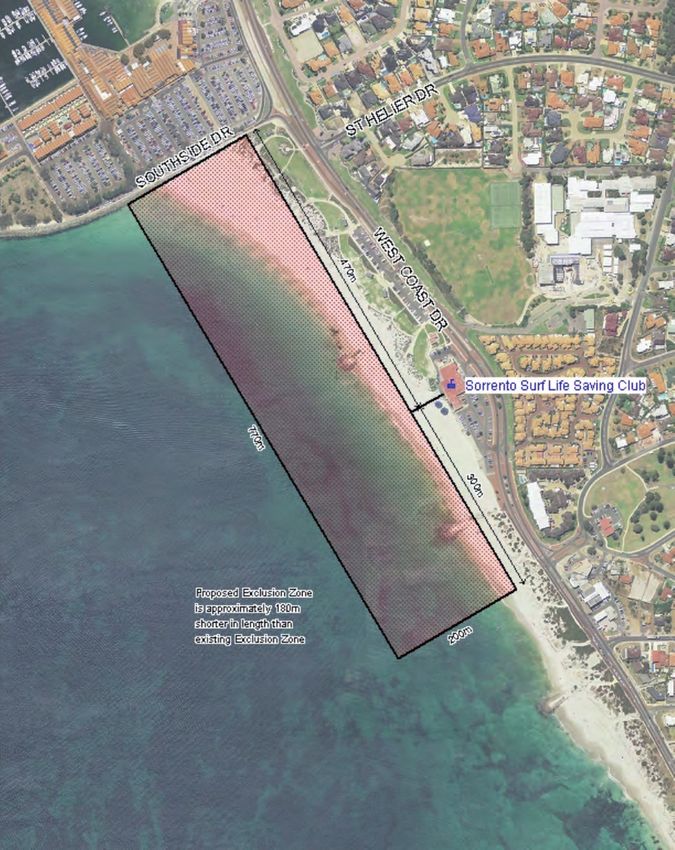
Beach Management Plan

Designated Recreational Intensity Areas          22

     Low-Intensity Recreation Zone               22

     Medium-Intensity Recreation Zone            23

     High-Intensity Recreation Zone              23

Structure		                                      24

Key Focus Area 1: Infrastructure                 25

     1.1   Paths                                 25

     1.2   Car Parks                             27

     1.3   Community Buildings                   28

     1.4   Toilets and Change Rooms              30

     1.5   Fencing                               33

     1.6   Signage                               34

     1.7   Park Assets                           35

Key Focus Area 2: Management                     37

     2.1   Recreational Activities               37

     2.2   Patrols                               41

     2.3   Commercial Trading                    42

     2.4   Events and Functions                  43

Key Focus Area 3: Development                    46

     3.1   Commercial                            47

References                                       49

APPENDIX 1                                       50

APPENDIX 2                                       51

APPENDIX 3                                       52

APPENDIX 4                                       54

APPENDIX 5                                       55

                                                              2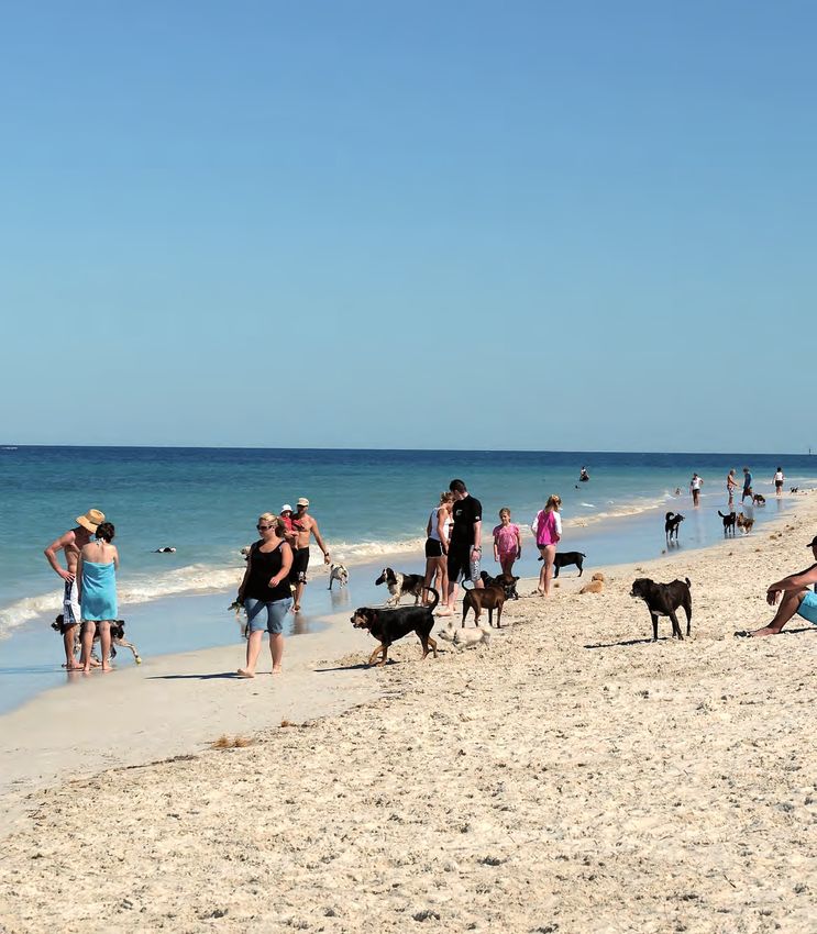
City of Joondalup

3

Beach Management Plan
Introduction
The coastline is a significant feature of the City’s natural assets and is considered integral to the health and wellbeing of
residents, as well as providing an attractive location for recreational activities on a regional basis.
The City prides itself on the pristine condition and health of its beaches, which is achieved through a combination
of good policy and maintenance programs. Water quality monitoring, beach sweeping, litter collection and smoking
prohibitions are all initiatives undertaken by the City with the aim of offering high quality experiences to its coastal
visitors.
The coastline stretches approximately 17 kilometres north from Marmion to Burns Beach and is home to several Bush
Forever sites that are of significant conservational value to the region. The natural diversity across the coastline includes
limestone cliff faces, coastal heathland and high dunes, which act as a regional green corridor for the movement
of fauna through linked coastal habitats. These natural assets require careful management to ensure the continued
prevalence of wildlife in the area and the protection of delicate coastal ecosystems.
Notwithstanding the natural amenity of the Joondalup coastline, the City also identifies the important role the coast
plays in tourism attraction and creating locations that are conducive to a diverse array of recreational activities. To
support these activities, coastal infrastructure and services are required to ensure the beach is accessible by users
and that activity nodes have quality complementary assets that enhance the coastal experiences of local residents and
visitors.
It is the City’s responsibility that recreational, tourism and conservational needs are balanced to ensure the long-term
sustainable use and management of the Joondalup coastline. To achieve this, the provision of coastal infrastructure
and services must be considered holistically to ensure the following:
Permitted areas for specific recreational activities are supported by appropriate infrastructure.
Identified areas for preservation and rehabilitation are effectively managed.
Appropriate areas are designated and promoted for recreation activities.
Coastal assets are of a high quality, appropriately located and effectively maintained.
This Plan will provide a framework to guide decision-making processes at the City which relate to the provision of
coastal infrastructure and services, taking into account the competing interests of conservationists, recreational users
and developers.
Statement on Sea-Level Rising
The City acknowledges that future environmental changes will occur in light of the effects of global warming and that
these changes will have impact on the City’s coastal areas. Given that information on the extent of these impacts is yet
to become readily available, this Plan does not address the issue of sea-level rising. However, statements made within
the Plan are cognisant of the fact that sea-level rising will become an issue in the future.
When information does become available, the City will ensure its integration into the Plan when undertaking scheduled
review processes.
4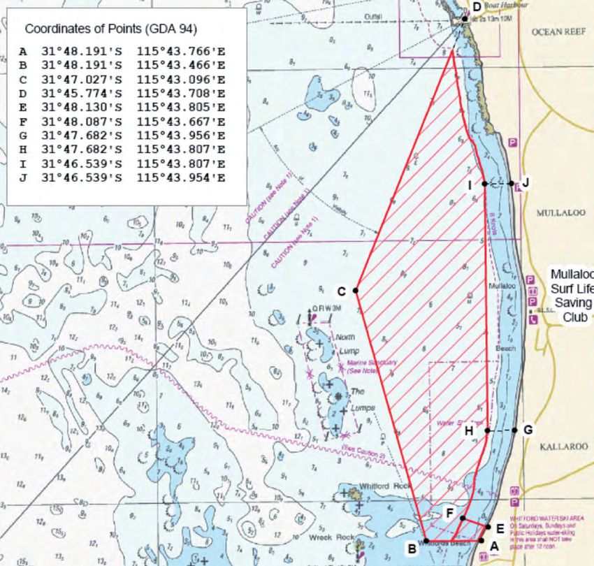
City of Joondalup

    Purpose
    The purpose of the City of Joondalup Beach Management Plan is to provide a management framework for the use,
    enjoyment, maintenance, protection, preservation and appropriate development of the lands that are covered by the Plan.

    It is acknowledged that there are a wide range of existing regional and City plans, strategies and policy statements that
    may deal with these concerns, however, the development of this Plan is intended to create an umbrella management
    framework that will provide the community with certainty about the City’s beach lands and enable the City to manage
    and develop it effectively.

5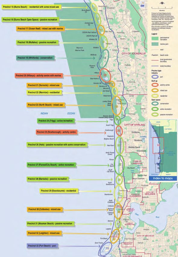
Beach Management Plan

Area Covered by Plan
The land covered under this Plan stretches from the City’s northern boundary at Burns Beach to its southern boundary
at Marmion, and 200 metres west into the sea from the low water mark to where the first sealed road commences in
the east.

                                                                                                                       6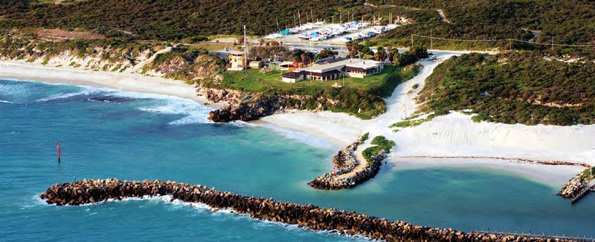
City of Joondalup
Planning Framework
PLANNING FRAMEWORK
Strategic Financial Management Plan 2009-2029
Joondalup 2020 Vision
Strategic Plan 2008-2011
Beach Management Plan
KEY FOCUS AREA KEY FOCUS AREA KEY FOCUS AREA KEY FOCUS AREA KEY FOCUS AREA
Leadership and The Natural Economic Prosperity The Built Community
Governance Environment and Growth Environment Wellbeing
Related Legal, Strategic and Policy Documents
There are several City of Joondalup legal, strategic and policy documents that are relevant to the Beach Management
Plan. The following highlights the pertinent sections of each document:
Local Laws:
Local Government and Public Property Local Law 1999
Trading in Public Places Local Law 1999
Health Local Law 1999
Policies:
Height of Buildings within the Coast Area (Non-Residential Zones) Policy:
Objective: ‘To ensure that the height of all development within the coastal area (non-residential zones) is
sympathetic to the protection and enhancement of the amenity and streetscape character of the surrounding
area.’
Reserves, Parks and Recreation Grounds Policy:
Objective: ‘To support best management practice for Council-controlled reserves, parks and recreation grounds
while recognising community needs and community and Council responsibilities.’
Community Facilities, Built Policy:
Objective: ‘To provide a range of community facilities within the community which meet local and regional
needs.’
7
Beach Management Plan
Management of Community Facilities Policy:
Objective: ‘To provide equity and access in the provision and management of community recreation facilities and
services, and to meet the changing needs of the community.’
Asset Management Policy:
Objective: ‘To ensure the organisation undertakes a structured and coordinated approach to asset management
that will promote sustainable infrastructure for the City of Joondalup.
Plans:
Joondalup 2020 Vision:
‘The City contains a comprehensive and well-connected network of cycle paths with high quality end of trip
facilities available for cyclists at key destinations.’
‘From an environmental perspective, the City is recognised as a world leader in preserving biodiversity with a
broad network of bushland and open space which is interconnected to support the movement of fauna.’
‘The City’s coastal environment is maintained in a pristine condition, with appropriate facilities to enable the
public to enjoy this wonderful asset. Such facilities include developments at the boat harbour in Ocean Reef
which make it an attractive, vibrant and memorable place to visit.’
That residents have easy access to a wide variety of recreational and leisure opportunities, from beautiful
parklands to active play areas, and community facilities of the highest quality.
Strategic Plan 2008–2011:
Mission Statement: ‘To undertake all our activities with the endeavour of meeting community expectations and
achieving sustainable lifestyles.’
Key Focus Area 2: The Natural Environment
Objective 2.1: ‘To ensure that the City’s natural environmental assets are preserved, rehabilitated and
maintained.’
Objective 2.2: ‘To engage proactively with the community and other relevant organisations in the preservation
of the City’s natural environmental assets.’
Key Focus Area 4: The Built Environment
Objective 4.2: ‘To progress a range of innovative and high quality urban development projects within the City.’
Key Focus Area 5: Community Wellbeing
Objective 5.2: ‘To facilitate healthy lifestyles within the community.’
Objective 5.4: ‘To work collaboratively with stakeholders to increase community safety and respond to
emergencies effectively.’
8
City of Joondalup
Environment Plan 2007–2011
Strategic Position: ‘To provide ongoing environmental leadership to the community to ensure the City retains
its natural environmental assets and preserves them for future generations to enjoy. The City of Joondalup will
achieve this goal through integrated planning and working in partnership with the community, key stakeholders
and relevant agencies.’
Focus Area 1: Land
Objective: ‘To incorporate environmental considerations into major land approval and planning processes and
to use external networks for establishing management and monitoring processes.’
Focus Area 3: Biodiversity
Objective: ‘To ensure the effective protection and maintenance of the City’s biodiversity.’
Biodiversity Action Plan 2009–2019
Aim: ‘For the City of Joondalup’s rich biological diversity to be understood, maintained and protected.’
Key Focus Area 2: Catchment Management
Objective: ‘To undertake appropriate management at a catchment scale in order to reduce negative impacts
on the City’s natural areas.’
Key Focus Area 5: Community Awareness and Education
Objective: ‘To improve awareness and understanding in the local community about biodiversity and its
importance.’
Key Focus Area 6: Community Engagement and Partnerships
Objective: ‘To improve outcomes by undertaking meaningful engagement and working in partnership with the
community, key stakeholders and relevant agencies.’
Joondalup Coastal Foreshore Natural Areas Management Plan
Conservation Zone:
Objective: ‘To provide for the protection of the environment, landforms, significant fauna habitat and
important vegetation communities while allowing low-intensity public access to areas that are of significant
environmental value.’
Low-Intensity Passive Recreation Zone:
Objective: ‘To provide facilities to cater for low levels of public use and recreation, whilst maintaining the
conservation value of the area.’
Medium-Intensity Passive Recreation Zone:
Objective: ‘To provide facilities to cater for medium levels of public use and recreation, whilst maintaining the
integrity of the vegetation and landforms of the area.’
High-Intensity Passive Recreation Zone:
Objective: ‘To provide facilities and management for high levels of passive recreational activities, while
implementing measures that will reduce the impact of these activities on the biophysical environment.’
9Beach Management Plan
Landscape Master Plan 2009–2019
Vision: ‘Landscaping in the City of Joondalup will be innovative, distinctive, functional and appealing, and valued
by residents and visitors and will evoke a sense of ownership and pride amongst its residents. This vision will
be achieved through the application of sustainable principles that will underpin all landscaping practices, with
a focus on environmental best practice and the preservation, enhancement and showcasing of local natural
biodiversity.”
Asset Management Plan 2009–2012
Vision: ‘The City of Joondalup’s vision for its Community Infrastructure is to provide the desired level of service in
the most cost effective manner for present and future customers. The City’s Asset Management Plan provides a
strategic road map and framework for successful achievement of this vision.’
Bike Plan 2009
Aims and Objectives: ‘To improve the cycling infrastructure by maintaining the already extensive network of
pathways, cycle lanes and signed bicycle routes servicing major destinations and the wider bicycle network
within the City and providing new infrastructure where necessary’
Tourism Development Plan 2005–2009
Vision: ‘The creation of a vibrant tourism industry that is environmentally responsible, socially sound and
economically viable. The industry is responsive to the community and visitors (tourists) and built on partnerships
and networks.’
Access and Inclusion Plan 2009-2011
Policy Statement: ‘The City of Joondalup is committed to ensuring that the community is accessible for, equal to
and inclusive of all members of the community and visitors.’
District Planning Scheme No. 2
Purpose: ‘To set out the way land is to be used and developed. It classifies areas for land use and includes
provisions to coordinate infrastructure and development in a locality. It also includes controls to ensure long-term
strategic planning objectives are achieved.’
10City of Joondalup
Development of Plan
The development of the Beach Management Plan occurred in several stages, as outlined in the diagram below:
Preliminary research
Workshop with internal stakeholders
Engagement with external stakeholders
1st draft Beach Management Plan
Internal consultation on draft
2nd draft Beach Management Plan
Draft document presented to Council
Community consultation on draft
Amendments to draft
Final draft presented by Council
11Beach Management Plan
Principles
The following guiding principles underpin the issue statements contained within the Beach Management Plan.
1. To maintain the natural integrity of the City’s coastline
2. To facilitate high quality experiences for visitors to coastal locations within the City through the
provision of quality infrastructure and services.
3. To enable a safe environment for beach users to undertake a variety of coastal activities.
4. To support activity diversity and growth within the Joondalup coastal region.
12City of Joondalup
Stakeholders
There are various State Government departments and agencies empowered with specific management responsibilities
along the State’s coastline. There are also several non-government organisations that assist in the delivery of coastal-
related services whom the City considers to be major stakeholders in the management of its beaches and coastal
reserves.
Below is a list of relevant organisations involved in the delivery of coastal management services, including a brief outline
of the extent of their jurisdiction and any activity restrictions they have applied within the City of Joondalup.
Department of Environment and Conservation
Extent of Jurisdiction:
The Department of Environment and Conservation is responsible for the following relevant coastal management duties:
Assisting the Marine Parks and Reserves Authority in the management and protection of marine parks and
reserves under the Conservation and Land Management Act 1984.
Identifying and establishing marine conservation reserves.
Developing and enforcing management plans for the ongoing protection and preservation of conservation areas.
Providing advice to other government agencies as to the activities that should be prohibited or restricted in and
around marine conservation areas (including: fishing, boating, surface-water sports, swimming, diving, and
snorkelling).
13Beach Management Plan
Restrictions Applied within the City of Joondalup:
The City of Joondalup is home to the Marmion Marine Park, which extends from Trigg Island in the south, to
Burns Beach in the north. The Marmion Marine Park Management Plan 1992-2002 has informed the direction of
management processes and actions by the Department in the Marine Park since 1992. Although the Marmion Marine
Park Management Plan 1992-2002 is due for review, actions and statements within the Plan are still applied by the
Department in the management of the Park. This includes the issuing of commercial operator licenses to businesses
that conduct water-based activities on Reserves managed by the Department. Within the City of Joondalup, this
extends to commercial recreational, tourism and fishing operations. Appendix 1 outlines the current area of the
Marmion Marine Park, the classified zones within the Park, and the locations where specific activities may be
undertaken.
Department of Planning
Extent of Jurisdiction:
The Department of Planning (formally Department of Planning and Infrastructure) is responsible for the following
relevant coastal management duties:
Providing advice and support to the WA Planning Commission and other relevant stakeholders in relation to
regional coastal planning.
Preparing the Metropolitan Regional Scheme.
Supporting Planning Policies for adoption by the WA Planning Commission
Restrictions Applied within the City of Joondalup:
The Department of Planning has developed the Draft Perth Coastal Planning Strategy, which will provide policy advice
and strategic guidance to stakeholders in the future planning and development of metropolitan coastal areas. The draft
Strategy classifies the State’s coastline into precinct areas, under which, appropriate land use and precinct types are
identified (i.e. ‘Built-Up Precincts’, ‘Open Space Precincts’ and ‘Industry Precincts’). Appendix 3 outlines the proposed
precinct areas and types within the City of Joondalup. When adopted, the Perth Coastal Planning Strategy will be
utilised by the Department of Planning and WA Planning Commission in the consideration of coastal development
applications. The City’s proposed management plan will need to be cognisant of the State planning prerogatives
illustrated in Appendix 3.
The Metropolitan Regional Scheme sets out a broad pattern of land use for the Perth Metropolitan Area by classifying
specific areas into zones to control the types of developments that can occur in each location. The Planning Policies
support the Scheme by creating a guide for decision-making processes by local governments when considering
planning applications. Planning Policies are non-statutory but are useful instruments for making consistent town
planning decisions. Relevant coastal Planning Policies prepared by the Department of Planning include:
Statement of Planning Policy No. 2.6: State Coastal Planning Policy
Statement of Planning Policy No. 3.4: Natural Hazards and Disasters Policy
Statement of Planning Policy No. 2.0: Environment and Natural Resources Policy
Statement of Planning Policy No. 2.8: Draft Bushland Policy for the Perth Metropolitan Region
14City of Joondalup
Western Australian Planning Commission
Extent of Jurisdiction:
The Western Australian Planning Commission is responsible for the following relevant coastal management duties:
Determining the approval of development applications within areas reserved for Parks and Recreation under the
Metropolitan Regional Scheme and for the Hillarys Marina.
Restrictions Applied within the City of Joondalup:
The Commission considers all applications on the advice of the Department of Planning who assess development
applications on the basis of existing legislation and approved planning policies and practices.
Department of Transport
Extent of Jurisdiction:
The Department of Transport (formally Department of Planning and Infrastructure) is responsible for the following
relevant coastal management duties:
Administering the Western Australian Marine Act 1982 (i.e.: designating (in specific areas): prohibited boating
areas, permitted waterski locations, and boating restrictions (relating to speed)).
Ensuring marine safety.
Licensing recreational boating and commercial vessels.
Managing oil pollution and coastal erosion.
Determining areas for boating restrictions.
Planning and developing coastal infrastructure (relating to harbours and boating facilities).
Acquiring and analysing coastal data (including: nautical charts, tide predictions, maritime geographical data,
and wave data)
Restrictions Applied within the City of Joondalup:
Within the City of Joondalup, the Department of Transport has placed the following restrictions on water-based
activities:
Prohibited Boating Location: located approximately 34 metres west of, and parallel to, the western Hillarys Boat
Harbour wall.
Restricted Boating Speed: limited to 8 knots within 200 metres of the shoreline along the entire length of the
Joondalup coast.
Permitted Waterski Area: see Appendix 2.
15Beach Management Plan
Department of Health
Extent of Jurisdiction:
The Department of Health is responsible for the following relevant coastal management duties:
Administering the Bacterial Monitoring Program (i.e.: testing popular swimming beaches within the Perth
Metropolitan Region for levels of bacteria to assess the potential safety impacts on beach users. This is assisted
by local government Environmental Health Officers).
Ensuring the water at swimming beaches is safe to swim in.
Classifying water bodies to help bathers decide where they want to swim.
Issuing warnings during pollution events.
Identifying bacterial pollution sources.
Looking for long-term bacterial trends.
Approving/disapproving the decommissioning of septic tanks with assistance from local government
Environmental Health Officers (particularly within sensitive coastal areas).
Approving/disapproving the installation of leach tanks and soak wells for large development applications.
Restrictions Applied within the City of Joondalup:
Restrictions may apply in the case of pollution and/or contamination events in the form of restricted public access.
Visit www.healthyswimming.health.wa.gov.au for data on seasonal micro-bacterial analysis within the City of
Joondalup.
Water Corporation
Extent of Jurisdiction:
The Water Corporation is responsible for the following relevant coastal management duties:
Coordinating Perth’s Long-Term Ocean Outlet Monitoring Program (PLOOM Program) (i.e.: monitoring outlet
areas for water quality, sediment quality, phytoplankton, marine habitats, heavy metal and pesticides, and
wastewater plumes).
Disposing of secondary treated wastewater from the Beenyup Wastewater Treatment Plant (located within the
suburb of Craigie) by discharge into the ocean (outlet located south of the Ocean Reef Marina).
Monitoring the impacts of the discharged secondary treated wastewater on the marine environment for nutrient
enrichment, pathogenic microorganisms, and contaminants.
Managing the State’s sewerage infrastructure.
16City of Joondalup
Coordinating the Infill Sewerage Program (i.e.: eradicating household septic tanks within the Perth Metropolitan
Region to reduce the health and environmental risks to future generations. Coastal areas within the City of
Joondalup that were subject to capital works under the Infill Sewerage Program are illustrated at
www.watercorporation.com.au. (n.b.: the Infill Sewerage Program only extends to household sewerage
connections therefore some City-owned buildings within coastal reserves are still on septic tank sewerage
systems, including: Mullaloo Surf Lifesaving Club, Jack Kikeros Hall, Sorrento Surf Lifesaving Club, Whitford
nodes toilets and change rooms, Mullaloo North toilet, Ocean Reef Sea Rescue Club, Ocean Reef Sea Sports
Club, Iluka Foreshore toilets, and Burns Beach change rooms.))
Restrictions Applied within the City of Joondalup:
Restrictions may apply in the case of pollution and/or contamination events in the form of restricted public access.
Department of Fisheries
Extent of Juisdiction:
The Department of Fisheries are responsible for the following relevant coastal management duties:
Managing recreational and commercial fishing in the Marmion Marine Park.
Determining catch limits and sizes for recreational and commercial fishing.
Ensuring fishing restrictions and prohibitions are adhered to in the Marmion Marine Park.
Administering licences for rock lobster, abalone, marron, south-west freshwater angling, and net fishing practices
(n.b.: licences for recreational boat fishing to be introduced in March 2010).
Restrictions Applied within the City of Joondalup:
The Department of Fisheries is responsible for the Marmion Marine Park in conjunction with the Department of
Environment and Conservation. Under the jurisdiction of the Department of Fisheries, the following restrictions apply in
the Park:
Spearfishing is prohibited within 1,800 metres of the shore, while spearfishing on compressed air is not
permitted throughout the rest of the marine park.
Access by boats is permitted throughout the Marine Park.
Line fishing from the shore is permitted in all areas.
Line fishing from a boat is permitted in all areas except Sanctuary Zones and the Watermans Reef Observation Area.
All shellfish and sea urchins are protected.
Abalone fishing is permitted in season in all areas except Sanctuary Zones and the Watermans Reef Observation Area.
Rock lobster fishing is permitted in all areas except the Sanctuary Zones and Watermans Reef Observation Area.
Commercial fishing is permitted in all areas except Sanctuary Zones and the Watermans Reef Observation Area.
Visit www.fish.wa.gov.au for the boundaries of the Marmion Marine Park.
17Beach Management Plan
Western Australian Police
Extent of Jurisdiction:
The Western Australian Police are responsible for the following relevant coastal management duties:
Operating the Water Police Coordination Centre as the Hazard Management Authority responsible for
coordinating marine search and rescue operations.
Operating the Diving Squad (i.e.: providing support to the WA Police in the areas of underwater search and
rescue, sonar scanning, and underwater crime scene investigation).
Operating the Marine Intelligence division (i.e.: providing specialised intelligence and investigative support to the
WA Police in the areas of marine-based collection, collation, analysis and dissemination of information from the
community and other sources).
Coordinating the Marine Watch crime prevention program (i.e.: providing a designated Local Marine Liaison
Officer at coastal police stations to assist the local community and maritime clubs and organisations in the
reporting of unusual or suspicious marine activity).
Operating Coast Radio Perth and monitoring HF and VHF marine channels for distress calls.
Assisting victims of any marine- or coastal-related crimes.
Restrictions Applied within the City of Joondalup:
Restrictions to coastal areas may be applied by the WA Police in the case of emergencies, accidents, criminal
monitoring, criminal activities, and/or crime scene investigations in the form of restricted access or restrictions relating
to special powers.
The Water Police Branch of the Western Australian Police Service is also responsible for enforcing any restrictions
imposed by the Department of Transport over water-based activities.
Fire and Emergency Services Authority
Extent of Jurisdiction:
The Fire and Emergency Services Authority is responsible for the following relevant coastal management duties:
Administering the Fire and Emergency Services Authority of Western Australia Act 1998, Fire Brigades Act 1942,
Bush Fires Act 1954, and Emergency Management Act 2005.
Coordinating and providing operational and financial support to the Volunteer Marine Rescue Services, State
Emergency Services, Volunteer Fire and Rescue Service and Bush Fire Brigades.
Providing emergency management training.
Conducting community engagement, research, liaison, risk planning, and evaluation in related to fire and
emergency services.
Restrictions Applied within the City of Joondalup:
Restrictions may be applied by the Fire and Emergency Services Authority in the case of emergencies and/or accidents
in the form of restricted access or restrictions relating to State Emergency special powers.
18City of Joondalup
Department of the Environment, Water, Heritage and the Arts (Federal)
Extent of Jurisdiction:
The Department of the Environment, Water, Heritage and the Arts is responsible for the following relevant coastal
management duties:
Approving development applications that may impact on any species listed under the Environmental Protection
and Biodiversity Protection Act 1999.
Restrictions Applied within the City of Joondalup:
The Department of Environment, Water, Heritage and the Arts is responsible for protecting and managing nationally
and internationally important flora, fauna, ecological communities and heritage places. The Department operates under
the Environmental Protection and Biodiversity Act 1999 and any developments that may impact upon species listed
under the Act, must be referred to the Department. In the City of Joondalup, there are 2 known species listed under the
Act, the Carnaby’s Black-Cockatoo (Calyptorhynchus latirostris) and the Graceful Sun Moth (Synemon gratiosa).
19Beach Management Plan
Non-Statutory Authority Stakeholders
Whitfords Volunteer Sea Rescue Group (Inc.)
Extent of Jurisdiction:
The Whitfords Volunteer Sea Rescue Group an independent not-for-profit organisation which is contracted under the
State Government and is responsible for the following relevant coastal management duties:
Acting as the State Government’s ‘first responder’ for all sea rescue incidents that occur between Alkimos in the
north, and City Beach in the South.
Providing crew, radio operators, support personnel, craft, equipment, and communication facilities for marine
search and rescue operations.
Providing training in powerboating, marine search and rescue, Recreational Skippers Ticket, Marine Radio
Operators Certificate, and coastal navigation.
Providing escort vessels for large events (e.g.: Rottnest Channel Swim, Dragon Boat Races in Hillarys Boat
Harbour).
Assisting Water Police Coordination Centre in search and rescue operations.
Wanneroo/Joondalup State Emergency Service Unit
Extent of Jurisdiction:
The Wanneroo/Joondalup State Emergency Service Unit is supported by the Fire and Emergency Services Authority.
The Unit is staffed by volunteers who undertake the following relevant coastal management responsibilities:
Acting as a ‘hazard management agency’ for flood, cyclone, storm, tsunami, and earthquake incidents.
Assisting in emergency repairs and restorations on buildings and essential services affected by natural disasters.
20City of Joondalup
Coordinating land searches (including beaches, cliffs and caves).
Assisting in incident control, planning and logistics.
Providing community education to service groups, senior centres and homes, local businesses and schools.
Assisting and supporting other emergency agencies, including the WA Police, where required.
Surf Life Saving Western Australia
Extent of Jurisdiction:
Surf Life Saving Western Australia is a volunteer-based, not-for-profit organisation which coordinates 28 surf life saving
clubs in Western Australia, including Mullaloo Surf Life Saving Club and Sorrento Surf Life Saving Club. In addition
to voluntary life saving services, club personnel are contracted by the City to conduct supplementary services on
weekdays during peak periods. The volunteers and contracted life savers undertake the following relevant coastal
management responsibilities:
Patrolling beaches and providing life saving services along the coastline (with additional services during peak
periods).
Providing life saving education to beach users (e.g.: sun smart, shark sightings).
Providing surf life saving training to club members and the community.
The City’s Local Government and Public Property Local Law 1999 permits life saving clubs to designate swimming
areas where the entry of boats, personal watercraft and surfboards is prohibited or restricted. Under the local law,
surf life saving clubs are also permitted to restrict bathing, fishing and launch life saving watercraft or any life saving
equipment for life saving activities. In addition, members of a life saving patrol have authority to direct beach users to
bathe within patrol flags and/or leave the water during dangerous conditions.
21Beach Management Plan
Designated Recreational Intensity Areas
In order to guide management decisions for the appropriate provision of coastal infrastructure and the designation of
permitted areas for recreational activity, the following recreation zones have been developed.
1. Low-Intensity Recreation Zone
2. Medium-Intensity Recreation Zone
3. High-Intensity Recreation Zone
The zones seek to establish a relationship between recreational intensity and coastal management decisions. They
have been determined based on the existing levels of public use and facilities present, as well as the sustainability of
each level of use relative to the landform and ecology of each area.
The description and location of the recreation zones below have been sourced from the City’s Coastal Foreshores
Natural Areas Management Plan 2002.
Where issue statements within the Beach Management Plan refer to ‘designated recreational intensity areas’, they are
referencing the recreational intensity zones, as illustrated in Appendix 4 of this document.
Low-Intensity Recreation Zone
The objective for this zone is to provide facilities to cater for low levels of public use and recreation, whilst maintaining
the conservation value of the area. Low-intensity recreation areas are generally those areas where:
access is almost entirely by either pedestrians or cyclists, along pathways or beach fronts and distant from car
parks and other facilities;
there is a low demand for access to the area;
existing recreational activities are passive and consist chiefly of walking, jogging, cycling, swimming or fishing;
existing recreational activities are generally not concentrated at nodes, but rather are spread relatively evenly at
low density along linear, accessible stretches; and
vehicular access to the beach is not permitted except by authorised vehicles.
22City of Joondalup
Medium-Intensity Recreation Zone
The objective for this zone is to provide facilities to cater for medium levels of public use and recreation, whilst
maintaining the integrity of the vegetation and landforms of the area. Medium-intensity recreation areas are generally
those areas where:
access is largely by pedestrians or cyclists, along pathways or beach fronts more than a short walk (i.e.: at least
a few minutes) from large car parks and other major recreational infrastructure, or a short walk from small car
parks;
there is a moderate demand for access to the area;
existing recreational activities include passive recreation and some more specialised activities, including walking,
jogging, cycling, swimming, fishing, animal exercising, boating, boat launching, sailing and windsurfing; and
some of the more active recreational activities can be localised to specific areas away from the general beach-
going public, such as areas for waterskiing, jet skiing, windsurfing and kitesurfing.
High-Intensity Recreation Zone
The objective for this zone is to provide facilities and management for high levels of passive recreational activities, while
implementing measures that will reduce the impact of these activities on the biophysical environment. High-intensity
recreation areas are generally those areas where:
popular swimming beaches are located (e.g.: Mullaloo Beach, Sorrento Beach) which are patrolled by surf life
savers and have associated infrastructure (e.g.: large car parks, grassed areas, buildings, toilet and change room
facilities) and a large number of access ways across the dunes to reach the beach;
boat launching facilities (other than beach launching) are located (e.g.: Ocean Reef Boat Harbour);
a high proportion of visitors arrive by car and walk a short distance from relatively large car parks to the site of
recreation, which is generally the beach;
there is a high demand for access to the area (n.b.: high-intensity use is often concentrated in time and space,
with peak usage during summer, and at nodes surrounding swimming beaches and associated infrastructure);
there is a moderate demand for access to the area; and
existing recreational activities are generally passive and include swimming, walking, jogging and cycling.
Other uses in this zone may require specialist infrastructure, such as boat launching ramps. Many of the areas of
high-intensity use consist of a relatively narrow strip of dune vegetation, which is often degraded by significant weed
invasion, vegetation disturbance, erosion, the effects of frequent, low intensity fire, and the effects of human traffic
across the dune vegetation (rather than using defined access paths).
See Appendix 4 for a visual representation of the recreational intensity zones outlined above.
23Beach Management Plan
Structure
The Beach Management Plan is divided into the following Key Focus Areas:
1. Infrastructure
2. Management
3. Development
Each Key Focus Area outlines the objectives associated with coastal asset provision and maintenance, activities
management, and commercial developments.
Issues under each Key Focus Area are identified and supported by issue statements which articulate the City’s position
on how specific issues should be resolved or managed. The issue statements do not seek to act as specific tasks or
actions, rather, they aim to provide guidance to decision-making processes which relate to the provision of coastal
services and infrastructure.
To support the Beach Management Plan, an Implementation Plan will be developed to articulate the processes and
mechanisms required to give effect to the issue statements within the Plan. This could include, for example:
amendments to existing local laws and polices;
development of guidelines;
erection of coastal signage;
engagement with external stakeholders; and/or
procedural amendments.
24City of Joondalup
Key Focus Area 1: Infrastructure
Coastal infrastructure is varied and provides for the needs of both local and regional communities. Close proximity to
the ocean makes coastal infrastructure more vulnerable to deterioration from conditions and high usage. Pressures on
infrastructure are generally seasonal and depend on the type of infrastructure. For example, coastal dual-use pathways
are generally popular throughout the year for walking, jogging and cycling, whereas car parks, toilets, and change room
facilities at popular swimming nodes are much more popular during the summer months. The following objectives
relate to the provision of all coastal infrastructures.
Objectives:
To provide quality infrastructure for the lowest ‘whole-of-life’ cost.
To provide adequate levels of infrastructure that are able to service the needs of the region within
designated activity locations.
To ensure the preservation of natural areas through effective infrastructure design and location.
1.1 Paths
The City’s coastline stretches over 17 kilometres and contains a large number of pathways. Most notably, the ‘coastal
dual-use pathway’, which runs north–south along the City’s coast and is utilised by local residents, tourists and regional
visitors year-round. This pathway currently extends from Marmion Beach in the south to Burns Beach in the north
(excluding a length of approximately 700 metres at the City’s northern border). Its total current length is approximately
21.7 kilometres.
Recent capital works undertaken in Sorrento-Marmion upgraded the most popular section of the dual-use pathway
by removing the concrete surface and replacing it with red asphalt. Certain locations along this section of the pathway
were also subject to widening as part of the works program.
At the northern end of the City, negotiations with the City of Wanneroo and the Department of Environment and
Conservation have commenced to determine under which arrangements an extension of the dual-use pathway from
Burns Beach to Mindarie should occur. The Council is yet to resolve its position on this issue, however, should the
project progress, the dual-use pathway within the City of Joondalup will effectively be extended 700 metres north to the
City of Wanneroo border.
There are also over 45 designated beach access paths along the City’s coast which the City is responsible for
maintaining, including the boat access ramp at Ocean Reef. Inspections for coastal paths are undertaken by the City’s
Operations Services while maintenance works are performed by both the City and external contractors. Inspections
and maintenance requirements occur on a scheduled and ‘as needs’ basis, which normally involve path sweeping
processes and repairs to concrete, asphalt and limestone surfaces.
Many informal beach access paths are also present along the coast; however, these are neither maintained nor
recognised by the City and are created by beach users who access the beach through illegal means (i.e. traversing
dunal systems). Most informal pathways lead to well-known fishing and surfing locations within dangerous limestone-
cliff areas and are created and reinforced on a seasonal basis. The City utilises coastal fencing, signage and patrols to
deter ongoing access to these areas and to reduce the use of informal beach access paths.
25Beach Management Plan
Issues and Issue Statements:
Congestion along the Mullaloo section of the dual-use pathway during the summer
Issue
months and inconsistent path widths between Hillarys and Burns Beach.
The City’s Bike Plan 2009 promotes the construction of a continuous coastal shared-path and
identifies the appropriate construction of off-road bicycle networks as an infrastructure priority.
As such, when undertaking assessments of the coastal dual-use pathway, the City should give
consideration as to whether the pathway meets current community needs and whether it can
Issue Statement 1 adequately enable multiple recreational activities to be undertaken simultaneously.
The potential for path widening and continuity should be priority design features considered
during path assessments and sections of path listed for refurbishment within the Capital Works
Program should be prioritised according to usage.
Link to Objectives: To provide adequate levels of infrastructure that are able to service the needs of the region within
designated activity locations.
Use of informal beach access pathways that lead to high-risk areas such as limestone
Issue
cliff locations.
The City discourages the use of informal beach access pathways and believes this should be
supported through the installation of adequate fencing infrastructure and educational signage
Issue Statement 2
along the coastal dual-use pathway to inhibit and discourage access to high-risk limestone cliff
locations.
Link to Objectives: To ensure the preservation of natural areas through effective infrastructure design and location.
Deterioration of the limestone and concrete, hard-stand surfaces on beach access
Issue paths and sand build-up at popular beach access points where hard-stand surfaces are
present.
It is the City’s position that limestone and concrete hard-stand surfaces should continue to be
utilised on beach access paths, however, the point in which hard-stand surfaces end should be
Issue Statement 3 in such a location that path degradation and sand build-up is minimised.
Any design and construction features of beach access paths should take into consideration
overall maintenance costs, including path reconstruction and the removal of accreted sand.
Link to Objectives: To provide quality infrastructure for the lowest ‘whole-of-life’ cost.
Excessive numbers of beach access pathways that are under-utilised and
Issue
inappropriately located.
It is the City’s position that in order to reduce overall maintenance costs and improve the
current standards of popular beach access paths, an assessment of the location and utilisation
levels of beach access paths be undertaken with a view to reducing the overall number of
Issue Statement 4 available paths.
Approved formal access paths should also be numbered to improve methods of identification
for maintenance purposes.
Link to Objectives: To provide adequate levels of infrastructure that are able to service the needs of the region within
designated activity locations.
26City of Joondalup
1.2 Car Parks
There are currently 24 car parking locations along the City’s coastline, 19 of which are owned and managed by the City
of Joondalup. Within these locations, there are a total of 4,737 car parking bays, with 2,768 concentrated within the
Hillarys Marina Complex. The remaining 1,969 are distributed across car parks and range in size from 12 bays per car
park to 372.
Although generally considered to be sufficient, the current level of coastal car parking bays is tested during the months
of summer when car parking demands at popular swimming beaches often exceed the level of bays available in
the area. This generally leads to incursions into residential areas as surplus visitors seek out alternative car parking
solutions that are close to the beach. Local residents often suffer a loss of amenity as a result of these incursions and
seek remedy from the City to patrol the affected residential areas more often during peak summer months.
Coastal car parks are also identified as anti-social hot-spots, demanding careful design and patrolling to ensure the
safety of car park users.
Issues and Issue Statements:
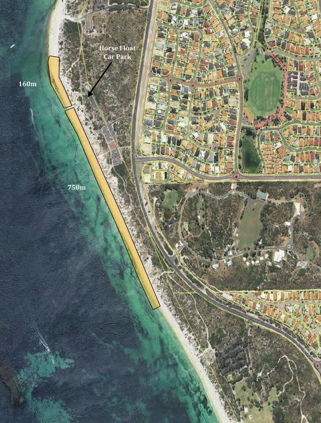
Issue Inadequate car parking at the current animal exercise beach car park in Hillarys.
The City acknowledges that current car parking facilities at the Hillarys Dog Beach have
reached capacity during peak summer periods. To maintain the amenity of the area, the
following approaches to car parking solutions should be preferred:
Issue Statement 5 Maximising car parking spaces within the existing car park footprint at the Hillarys Dog
Beach; and
Prohibiting horse exercising on the beach and reconfiguring the horse float car park to
accommodate a greater number of car bays for dog owners.
Link to Objectives: To provide adequate levels of infrastructure that are able to service the needs of the region within
designated activity locations and to ensure the preservation of natural areas through effective infrastructure design
and location.
Inadequate car parking facilities during the summer months between Mullaloo and
Issue
North Mullaloo Beaches and at Sorrento Beach.
The City acknowledges that current car parking facilities at Mullaloo and Sorrento Beach
have reached capacity during peak summer periods. To maintain the amenity of the area, the
following approaches to car parking solutions should be preferred:
Maximising car parking spaces within existing car park footprints if possible.
Issue Statement 6
Investigating possible shared-use arrangements on nearby private land.
Investigating the construction of additional car bays within road reserves, excluding
areas adjacent Tom Simpson Park in Mullaloo.
Investigating the introduction of alternative transport solutions.
Link to Objectives: To provide adequate levels of infrastructure that are able to service the needs of the region within
designated activity locations.
27Beach Management Plan
Poorly located coastal car parks that do not correlate to popular beach access points or
Issue
other coastal attractions.
Numbers of available car parking bays should correlate to the level of recreational intensity the
City wishes to encourage in the area and in locations where beach access is appropriate and
promoted by the City. As such, designated high-intensity recreation areas should have the
Issue Statement 7 greatest number of total available parking bays, while designated medium-intensity recreation
areas should concentrate car parks to locations where access is encouraged. Designated low-
intensity recreation areas should have the least number of available parking bays in order to
discourage access and to promote the preservation of native vegetation.
Link to Objectives: To provide adequate levels of infrastructure that are able to service the needs of the region within
designated activity locations.
1.3 Community Buildings
There are currently five community buildings located within coastal reserves in the City, four of which are subject to
ongoing leasing arrangements. All but one, are located within high-intensity recreation areas with the fifth located in a
medium-intensity recreation area. This particular community building (Jack Kikeros Community Hall in Burns Beach)
experiences moderate utilisation levels from casual and regular community hire arrangements, which vary in activities
from small functions to community group meetings.
Two of the five coastal community buildings, namely, the Whitfords Volunteer Sea Rescue Building and the Ocean
Reef Sea Sports Club, are subject to lease arrangements and will be subject to temporary removal as part of the
development of the Ocean Reef Marina. Concept plans for the Marina indicate that the buildings will be reconstructed
within the Marina complex, although, relocated from their current premises to a location which complements the
overall layout of the development site. The buildings’ redesign is unknown at this stage, however, it will be subject to
consultation prior to the reconstruction phase.
The remaining coastal community buildings are surf lifesaving clubs, namely, Mullaloo Surf Life Saving Club and
Sorrento Surf Life Saving Club, which are also subject to ongoing leasing arrangements. The clubhouses serve as a
base for surf life saving activities within the area of their location and can be hired on a casual basis for functions and
events. These buildings experience high utilisation rates and serve an important function in facilitating safe swimming
environments for beach users near the buildings’ location.
In terms of the building materials used in the construction of coastal community buildings, they tend to vary depending
on the age of the building, as continual modifications to building and design codes are adopted. The construction dates
of current coastal community buildings are as follows:
Building Construction Date
Sorrento Surf Life Saving Club Rooms 1972
Ocean Reef Sea Sports Club Rooms 1980
Whitfords Volunteer Sea Rescue Building 1980
Jack Kikeros Community Hall 1983
Mullaloo Surf Life Saving Club Rooms 1991
28City of Joondalup
Issues and Issue Statements:
Issue Not all coastal sites are supported by community buildings.
Only high or appropriate medium-intensity recreation areas along the coast should be
supported by community buildings. The buildings should also be ‘fit for purpose’ and facilitate
Issue Statement 8
either coastal-related activities (e.g.: surf life saving, watercraft sports, sea rescue operations,
etc.) or dining experiences which maximise coastal views in the buildings’ design.
Link to Objectives: To provide adequate levels of infrastructure that are able to service the needs of the region within
designated activity locations.
Issue Use of inappropriate building materials within a marine environment.
All coastal construction projects undertaken by the City should require specifications that
stipulate the use of appropriate building materials which aim to decrease the ‘whole-of-life’
Issue Statement 9 cost of the infrastructure asset.
Coastal building refurbishments and major repairs should also be scheduled in accord with
the City’s Building Asset Management Plan.
Link to Objectives: To provide quality infrastructure for the lowest ‘whole-of-life’ cost.
Accessibility features within coastally-located community buildings that do not meet
Issue
current Australian Standards for access.
The City strongly supports building design features which enable accessibility for people with
disabilities and which accord with current Australian Standards for access. It is the City’s
position that all new community buildings should adopt high standards for accessibility within
the design phase, while existing buildings should apply threshold criteria to determine when
Issue Statement 10 major accessibility alterations are included in scheduled works programs. If scheduled works
are in excess of $200,000 or will apply to over 25% of the building’s existing floor space,
major accessibility design features should be included in the design phase of the project,
while works below these amounts should consider the inclusion of minor accessibility design
features.
Link to Objectives: To provide adequate levels of infrastructure that are able to service the needs of the region within
designated activity locations.
Issue External vandalism of coastal community buildings by non-building users.
The City supports the implementation of CPTED (Crime Prevention through Environmental
Issue Statement 11 Design) principles in the design and construction of existing and new community buildings to
reduce incidences of external vandalism.
Link to Objectives: To provide quality infrastructure for the lowest ‘whole-of-life’ cost.
29Beach Management Plan
1.4 Toilets and Change Rooms
There are currently twelve toilet and change room facilities located across the City’s coastal reserves, all of which vary
in size and quality. Seven of these facilities are located within medium-intensity recreation areas, while the remaining
five are located within high-intensity recreation areas. There are no toilets and change room facilities provided within
low-intensity recreation areas, as the City discourages access to these locations due to their high conservational value.
In terms of the community’s perception of coastal public toilet facilities, residents, beach visitors and reserve users
have on many occasions articulated their concern that such facilities may attract anti-social behaviour in a variety of
forms. As such, mechanisms for reducing potential incidences of anti-social behaviour require careful consideration
by the City in planning for the provision of public facilities. This includes the determination of appropriate locations,
design elements and management devices to ensure that public toilet facilities are available for the community’s use,
while acknowledging the impacts that their provision can have on surrounding residents. Modern concepts of design,
such as CPTED principles (Crime Prevention through Environmental Design), aim to reduce incidences of anti-social
behaviour in and around public facilities, principles of which the City has committed to incorporating into new City
facilities as part of its Community Safety and Crime Prevention Plan.
Similarly to coastal community buildings, the design and building materials used to construct coastal toilet change
room facilities vary due to their differing levels of refurbishment and construction ages. As such, the incorporation
of modern design features such as CPTED principles (Crime Prevention through Environmental Design) and new
accessibility requirements for the disabled are not consistent across facilities. To overcome this issue of inconsistency,
the City plans to develop a Public Toilet Strategy which will provide guidance on the future provision of public toilets
within the City (including coastal reserves). This will aim to stipulate minimum design and construction standards for
new and existing facilities, as well as examining appropriate locations for their construction.
30You can also read