Currawinya National Park - Draft Resource Information - July 2020
←
→
Page content transcription
If your browser does not render page correctly, please read the page content below
Currawinya National Park
Draft Resource Information

                             July 2020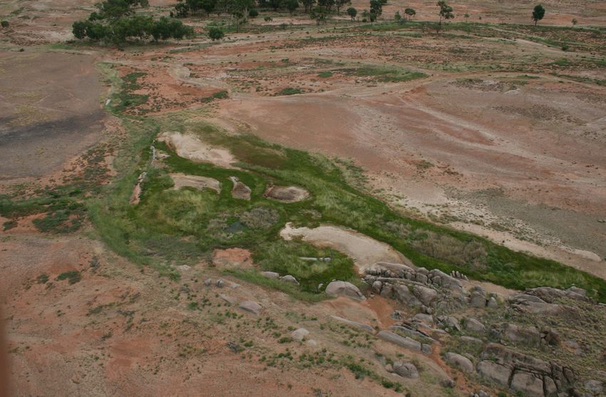
Prepared by: Queensland Parks and Wildlife Service, Department of Environment and Science

© State of Queensland, 2020

RI207. July 2020

Front cover photo: Budjiti lookout, Mulga woodlands © Robert Ashdown 2018

Artwork by Shanon Spies © 2019

Aboriginal and Torres Strait Islander People should be aware that this document may contain images or names of deceased persons in
photographs and printed material that some people may find distressing.

The Queensland Government supports and encourages the dissemination and exchange of its information. The copyright in this
publication is licensed under a Creative Commons Attribution 3.0 Australia (CC BY) licence.

Under this licence you are free, without having to seek our permission, to use this publication in accordance with the licence terms.

You must keep intact the copyright notice and attribute the State of Queensland as the source of the publication and Budjiti Aboriginal
Corporation as the copyright owner in relation to traditional cultural knowledge sections of the publication, as well as acknowledging the
Budjiti People as the source of that traditional cultural knowledge and site identification information contained in the publication.

The Budjiti Aboriginal Corporation approves the current Currawinya National Park Management Plan as a framework document for the
Budjiti and QPWS&P to undertake our custodial obligations under the Commonwealth Government, Queensland Government, local
government and Budjiti law.

For more information on this licence, visit http://creativecommons.org/licenses/by/3.0/au/deed.en

Disclaimer

This document has been prepared with all due diligence and care, based on the best available information at the time of publication. The
department holds no responsibility for any errors or omissions within this document. Any decisions made by other parties based on this
document are solely the responsibility of those parties.

If you need to access this document in a language other than English, please call the Translating and Interpreting Service (TIS National) on
131 450 and ask them to telephone Library Services on +61 7 3170 5470.

TThispublication can be made available in an alternative format (e.g. large print or
audiotape) on request for people with vision impairment; phone +61 7 3170 5470 or
email .
Public consultation on planning documents
Good planning is an important part of effective park management: it helps us understand where we are now, where we want to
be, and how we are going to get there. It is the first step in the Values-Based Management Framework, an adaptive management
cycle used by the Queensland Parks & Wildlife Service and Partnerships (QPWS&P) for setting the goals, strategic direction and
priorities for park management. The cycle incorporates phases of monitoring, evaluating and reporting to inform how we are
tracking and where we need to adapt management to achieve our goals and good outcomes for Queensland’s parks, forests and
reserves.

Planning for each park is brought together and communicated through a number of planning documents—management plans
and statements; resource information; thematic strategies and action plans. The hierarchy and purpose of these planning
documents is shown in Figure 1.

For Currawinya National Park, the following planning
documents are available:

• draft management plan
• draft resource information
• draft visitor strategy.

An invitation to comment

Budjiti native title holders, organisations and members
of the public are encouraged to have a say on the
management of Currawinya National Park: you are
invited to review the management plan, resource
information document and visitor strategy and put
forward a submission.

Written submissions on the draft management plan
can be made via the Queensland Government’s Get
Involved website at www.getinvolved.qld.gov.au.

The Minister will consider all submissions when
finalising the management plan.

For further information on the draft management plan
or the planning process, please visit the Department
of Environment and Science at website www.des.qld.
gov.au.
                                                               Figure 1. Hierarchy of planning documents and their purpose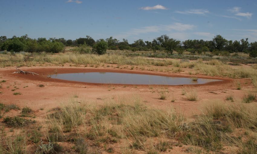
Contents
1. Introduction.....................................................................................................................................................................................1

2. Currawinya National Park.................................................................................................................................................................2

   2.1 Budjiti People.............................................................................................................................................................................. 4
   2.2 Ecosystems and biodiversity........................................................................................................................................................ 5
        2.2.1 Regional ecosystems.......................................................................................................................................................... 5
         2.2.2 Ramsar wetlands............................................................................................................................................................... 5
        2.2.3 Important wetlands............................................................................................................................................................ 5
        2.2.4 Wetlands............................................................................................................................................................................ 6
        2.2.5 Catchment.......................................................................................................................................................................... 6
        2.2.6 Artesian springs................................................................................................................................................................. 9
   2.3 Ecosystems services.................................................................................................................................................................... 9
        2.3.1 Aesthetic values................................................................................................................................................................. 9
   2.4 Species..................................................................................................................................................................................... 10
        2.4.1 Native animals................................................................................................................................................................. 10
        2.4.2 Native plants.................................................................................................................................................................... 11
   2.5 Geophysical features................................................................................................................................................................. 12
        2.5.1 Rangeland landscapes...................................................................................................................................................... 12
        2.5.2 Soils................................................................................................................................................................................. 12
   2.6 Recreational opportunities........................................................................................................................................................ 13
        2.6.1 Camping........................................................................................................................................................................... 13
        2.6.2 Day-use areas................................................................................................................................................................... 13
   2.7 Ecotourism................................................................................................................................................................................ 13
        2.7.1 Tourism and visitor opportunities...................................................................................................................................... 13
   2.8 Historic cultural heritage........................................................................................................................................................... 14
        2.8.1 Pastoral history................................................................................................................................................................ 14
   2.9 Partnerships.............................................................................................................................................................................. 15
   2.10 Scientific research................................................................................................................................................................... 15
   2.11 Education................................................................................................................................................................................ 15
   2.12 Fire.......................................................................................................................................................................................... 16
   2.13 Pests....................................................................................................................................................................................... 16
        2.13.1 Pest plants..................................................................................................................................................................... 16
        2.13.2 Pest animals................................................................................................................................................................... 17

3. Appendices ...................................................................................................................................................................................18

   Appendix 1. Legal, policy and management commitments............................................................................................................... 18
   Appendix 2. Regional ecosystems of significance............................................................................................................................ 19
   Appendix 3. Species of conservation significance............................................................................................................................ 20
   Appendix 4. Species listed in international agreements................................................................................................................... 21
   Appendix 5. Places of historical value.............................................................................................................................................. 22
   Appendix 6. Pests ........................................................................................................................................................................... 23
   Appendix 7. Wetland management.................................................................................................................................................. 25

4. References.....................................................................................................................................................................................26

Currawinya National Park Resource Information
Draft for consultation
                                                                                                  iv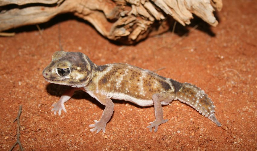
QPWS and Partnerships works with First Nations peoples
                      to ensure the protection of Country and culture. We pay our
                   respects to all peoples, and to the Elders past, present and future,
                           for land and sea on which we work, live and walk.

1. Introduction
The Queensland Parks and Wildlife Service (QPWS) management                           Resource information is a compendium of park information and
planning process aligns with the Values-Based Management                              a supporting document for management plans and management
Framework (VBMF), an adaptive management cycle that                                   statements. It contains background information about a park’s
incorporates planning, prioritising, doing, monitoring, evaluating                    purpose, values, resources, and legal and administrative
and reporting into all areas of our business (Figure 2).                              framework.
Management plans and statements set the strategic management
direction, guiding the next tier of planning and the development                      Information about QPWS’s Values-Based Management
of thematic strategies, which in turn inform and prioritise our on-                   Framework is available on the Department of Environment and
ground operations.                                                                    Science (DES) website at www.des.qld.gov.au.

 Figure 2. Phases of the VBMF cycle for planning and the hierarchy of planning documents

Currawinya National Park Resource Information
Draft for consultation
                                                                                  1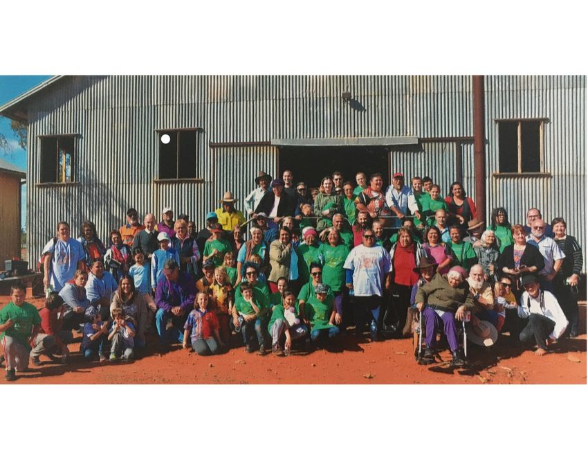
2. Currawinya National Park
Currawinya National Park is one of Queensland’s largest national            Currawinya protects 11 animal and nine plant species listed
parks and is located near Hungerford, about 830 kilometres west             as threatened under the Nature Conservation Act 1992 (Qld)
of Brisbane in the state’s south-west (Figure 3). Its lakes, rivers         (NCA) and EPBC, as well as examples of both Budjiti and historic
and wetlands are a striking contrast to the surrounding sandy               cultural heritage.
plains and rocky ranges and play a critical role for migratory birds.
Currawinya is recognised as being of international importance               A native title consent determination was handed down to the
under the Convention on Wetlands of International Importance                Budjiti People in June 2015 under the Native Title Act 1993
(Ramsar Convention). Lakes Numalla and Wyara, Paroo River                   (Cwlth). An Indigenous Land Use Agreement (ILUA) with the
waterholes and the Eulo artesian springs supergroup are also                Budjiti Aboriginal Corporation (QCD2015/007) details the
recognised as being of national significance in the Directory of            responsibilities of the state and the Traditional Owners. The
Important Wetlands in Australia (DIWA). They support migratory              continued connection to country and the protection of significant
bird species recognised under the Environment Protection and                Budjiti sites is of great importance to the Traditional Owners of
Biodiversity Act 1999 (Cwlth) (EPBC) and international treaties.            this Country.

The protected area conserves 25 regional ecosystems (REs),                  At Currawinya National Park, visitors enjoy the remoteness of
including one listed as ‘endangered’ and 11 ‘of concern’.                   the natural setting and have the opportunity to pursue several
Communities of native species dependent on natural discharge                safe, low-key, nature-based recreational activities such as
of groundwater from the Great Artesian Basin are listed as                  camping, birdwatching, bushwalking and photography. With
‘endangered’ (EPBC). Currawinya National Park protects two                  the 2015 expansion, even more recreational opportunities have
category 1a spring complexes within a single regional ecosystem             become available. This makes Currawinya a regionally important
(RE 6.3.23), providing habitat for numerous spring endemic or               destination, particularly in the winter months and especially for
disjunct populations. These springs also have important Budjiti             keen birdwatchers.
and historic cultural links.

Currawinya protects 90 per cent of the regionally restricted mulga
associated with ‘of concern’ granite outcrops (RE 6.12.1), the
only protected area where this community occurs.

Currawinya National Park Resource Information
Draft for consultation
                                                                        2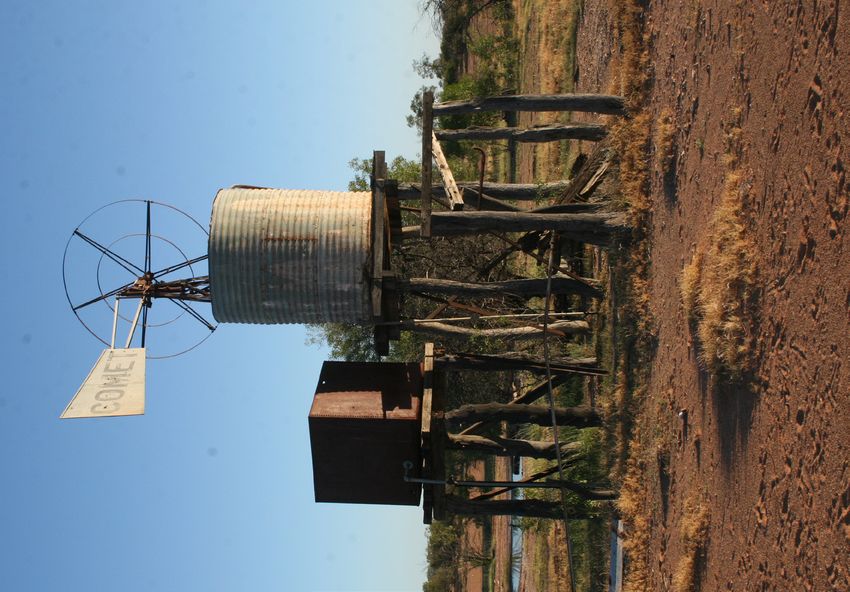
Figure 3. Budjiti native title consent determination area, showing the significance of Currawinya National Park

Currawinya National Park Resource Information
Draft for consultation
                                                                                     3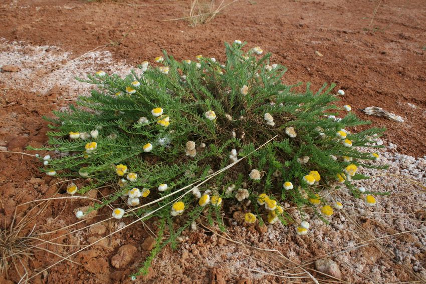
2.1 Budjiti People
The Budjiti or Paroo River People have a long and strong cultural
connection with Currawinya National Park and the Paroo River
(Akers 2015). Archaeological evidence indicates that the Youlain
Springs area, west of the park, may have been occupied about
13 000 years before present (Robins 1999). Currawinya, its river
and wetland environments were considered very productive,
providing year-round food for the Budjiti Peoples
(McKellar 1984).

The Currawinya area contains a wide range of Budjiti cultural
sites, the densities and size of which vary across the area
and are being progressively recorded. A native title consent
determination was handed down to the Budjiti People on 23
June 2015. The claim area includes around 356 000 hectares
of protected area estate currently managed by QPWS, including
Boorara, Werewilka and Oolamon. A strong working partnership
has been developed between QPWS and the Budjiti Aboriginal
Corporation under a signed Protected Area ILUA. QPWS future
works and activities will be validated under a separate Validation
ILUA.

Figure 4. Budjiti People celebrating their native title determination at Currawinya, 3 July 2015 © Sue Akers, Bush Heritage 2015

Currawinya National Park Resource Information
Draft for consultation
                                                                                      4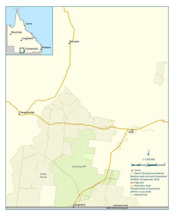
2.2 Ecosystems and biodiversity
The concentration and diversity of its wetlands make Currawinya            The acquisition of the Boorara, Werewilka and Oolamon
distinct among Australian desert wetlands (Timms 1997). They               properties a very significant addition to the reserve system of
range in size from 3400 hectares (Lake Wyara) to claypans                  the Mulga Lands Bioregion, adding to the comprehensiveness,
less than one hectare, from clear to very turbid, saline to fresh,         representativeness, adequacy and protection of endangered
vegetated to bare, and from ephemeral to permanent (Figure 5).             communities and species. They are a major extension to
These wetlands can be divided into four broad groups: saline               Currawinya National Park and are part of a significant wildlife
lakes, freshwater lakes, claypans and riverine waterholes.                 corridor stretching north to Lake Bindegolly National Park. The
                                                                           area contains a significant portion of the upper catchments of
The lakes, ephemeral lakes and claypans conserved within                   Werewilka and Boorara creeks, which flow into the lake systems
the park provide major saltwater and freshwater habitats for a             of the Ramsar-listed Currawinya National Park.
large variety of inland and migratory bird species. While the two
larger lakes, Wyara and Numalla, are separated by only a few
kilometres, they are significantly different chemically and in their
                                                                           2.2.1 Regional ecosystems
surrounding vegetation. The clear saline water of Lake Wyara               Currawinya contains 25 REs, including one ‘endangered’ and 11
supports dense beds of macrophytes, including the flowering                ‘of concern’ (Appendix 2). About 50 per cent of the park supports
plants sea tassel Ruppia maritima, widgeon grass Ruppia                    mulga Acacia aneura and poplar box Eucalyptus populnea
sp. aff. Tuberosa, water mat Lepilaena bilocularis, Lepilaena              low open shrublands on sandplains. Dunefields covered in
sp. aff. Cylindrocarpa, and the macro-algae (charophytes)                  shrublands form a mosaic with numerous small claypans and
Lamprothamnium papulosum, Nitella spp. and Chara australis.                saltpans. Dissected tablelands, ranges, low hills and associated
The vegetation fringing the shoreline is dominated by low                  undulating plains occur in the central north and western sections
shrubland of samphire Halosarcia pergranulata, pigface                     of the park. These support bastard mulga Acacia stowardii and
Sarcozona praecox, red trefoil Lotus cruentus, monkey flower               turpentine mulga Acacia brachystachya communities.
Mimmulus repens and mulka Eragrostis dielsii. The abundant
macrophytes and large populations of invertebrates are attractive          The channels and flood plains of the Paroo River form the south-
to waterbirds: Lake Wyara can support more than 85 000                     eastern boundary of the park and support yapunyah Eucalyptus
waterbirds (41 species); the smaller Lake Yumberarra, at its peak,         ochrophloia and alluvial gidgee Acacia cambagei communities
supports the greatest density of birds at 115 birds per hectare            (Queensland Government 1999). One of the most significant
(59 species) (Timms & McDougall 2004; McDougall & Timms                    communities is scattered mulga A. aneura around granite
2000; Kingsford 1995). Twenty-two species are listed under                 bounders (RE 6.12.1): this is listed as ‘of concern’. The park
international migratory bird protection agreements (Appendix 4).           protects 90 per cent of the state target of the mulga community
                                                                           (RE 6.12.1 – ‘of concern’) and is the only protected area where
Little light penetrates the highly turbid freshwater of Lake               this regional ecosystem is found. The granite outcrops associated
Numalla. These low light levels mean that macrophytes like                 with this community have been dated between 230 and 310
the red water milfoil Myriophyllym verrucosum, water mat                   million years old (Dawson 1974) and are of geological interest.
Lepilaena bilocularis and charophytes Nitella sp. can only grow
in shallow water at the margin of the lake. Fringing vegetation
includes pinrush Cyperus gymnocaulos, boobialla Myoporum
                                                                           2.2.2 Ramsar wetlands
montanum, sesbania pea Sesbania cannabina, belalie Acacia                  Currawinya Lakes was listed under the Convention on Wetlands
stenophylla, lignum Muehlenbeckia florulenta and black box                 of International Importance on 11 March 1996. The Ramsar-
Eucalyptus largiflorens. The lake supports populations of shrimp           nominated area of national park includes the 1991 gazettal
Macrobrachium sp. and native fish such as yellowbelly Maquaria             (147 730 ha) and 1992 gazettal (3570 ha), a total area of
ambigua, bony bream Nematalosa erebi and spangled perch                    151 300 hectares (Appendix 7). At the time of listing, Currawinya
Leiopotherapon unicolor. These attract fish-eating waterbirds,             National Park fulfilled all six of the nomination criteria,
including the Australian pelican Pelicanus conspicillatus, great           reinforcing the significance and diversity of Currawinya’s
cormorant Phalacrocorax carbo, pied cormorant Phalacrocorax                wetlands (NPRSR 2014).
varius, little black cormorant Phalacrocarax sulcirostrus, little
pied cormorant Phalacrocorax melanoluecos and darter Anhinga
melanogaster.
                                                                           2.2.3 Important wetlands

Currawinya National Park Resource Information
Draft for consultation
                                                                       5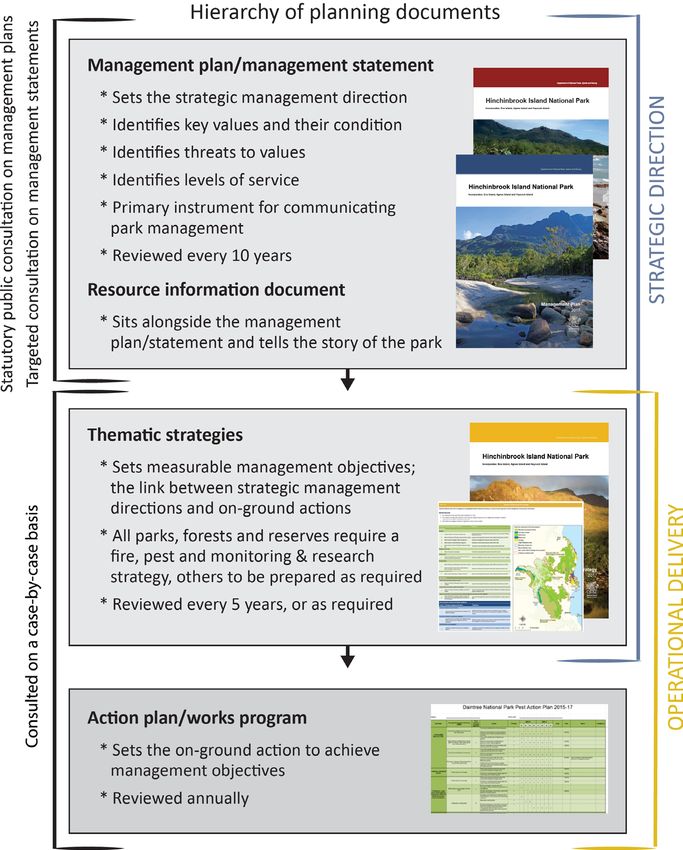
Currawinya National Park contains four inland (B) wetland types Currawinya is unique in that the majority of the catchments of
listed on the Directory of Important Wetlands in Australia: Lake the two major lake systems, Wyara and Numalla, are within the
Numalla Aggregation, QLD123 (10 715 ha); Lake Wyara, QLD124 park boundary. Lake Wyara is situated to the west of the park
(6015 ha); Paroo River Waterholes – Caiwarro Area, QLD176 and is filled by six creek systems. Werewilka Creek is the most
(25 ha); and Eulo Artesian Springs Supergroup, QLD177 (30 ha). significant of these, draining from the Willies Range and the
western slopes of the Walters Range. Lake Numalla receives
water primarily from Boorara Creek, draining the eastern slopes
2.2.4 Wetlands
of Willies Range and the western slopes of Hoods Range, and the
At Currawinya, wind erosion (deflation) is the most important Paroo River via Carwarra Creek, which in turn drains the southern
process influencing the formation of all wetlands, except riverine slopes of Hoods Range. Lakes Kaponyee and Yumberarra are fed
waterholes, which are formed by vertical erosion during floods. by Kaponyee Creek. Lake Karatta is fed by Stinking Well Creek.
Beaches and spits are common features in many of the wetlands, Soil destabilisation, resulting from grazing stock denuding
their formation promoted by wind, sediment supply and water groundcover, has caused some infilling of Lake Karatta (Timms
presence (Timms 1997). 1997).
The variable influence of riverine floodwater adds to the diversity Sedimentation build up on the western side of Lake Wyara is
and relative permanence of Currawinya’s wetlands. Although, a potential threat as it could allow feral animal access to the
Paroo River floods in most years, the timing and height will vary: islands used for bird breeding. Rapid sedimentation at the
minor floods affect only the riverine waterholes, while the largest mouths of Youlaingie and Benegara creeks might eventually
inundations may reach Lake Wyara and even a few of the pans allow terrestrial predators access to bird breeding colonies. The
on the outer floodplain. This irregular supply of floodwater is area needs to be regularly monitored. Siltation of the lakes, and
important for the functioning of the wetlands. It lengthens the other water bodies within the park, is occurring, as indicated
time each lake or pan contains water and alters the quality (i.e. by the reddish colour of the water after rainfall. High turbidity,
freshness, acidity and turbidity) of water in the system; these caused by siltation, prevents light from penetrating the water
changes, ultimately, have biological ramifications (Timms 1997). and results in less primary production. It is therefore imperative
that the catchments of the park’s water bodies are protected
Timms (1997) has documented basic yet detailed information from impacts that degrade both water quality and quantity
on the geomorphology and hydrology of Currawinya’s (Timms 1997).
wetlands together with an assessment of the physicochemical
characteristics of the waters and their invertebrate populations. Currawinya National Park occurs within the bounds of the
The major threats to the long-term viability of the wetland Murray–Darling Basin. Activities within the park and further up
systems within the park are briefly outlined: sedimentation, the catchment have an impact downstream.
introduced fish, feral pigs and visitor use.
The Currawinya lakes arguably represent the most important
Sedimentation of the wetlands is the issue of most concern. Lake wetlands for waterbirds in arid Australia (Kingsford & Porter
Karatta, the worst affected, has shallowed by 42 centimetres in 1999). Altering the river flows represents a major threatening
the last few decades due to sediment deposits of about process to the park’s ecology. Loss of habitat through changed
200 000 m3 (Timms 1997). This causes increased turbidity and flows not only leads to a loss of ecosystem diversity, but may
could lower the lake’s productivity and impact the foraging, have a detrimental impact on the genetic and species diversity
drinking and breeding patterns of waterbirds and other wildlife. as all levels of diversity are inextricably linked (Watts 1999).
Given that the Currawinya wetlands are Wetlands of International
At Currawinya, sedimentation is occurring as a result of erosion Importance under the Ramsar Conventions, there is an obligation
within local catchments and from table drains from nearby roads under national and state agreements to conserve the ecological
being directed into wetlands. integrity of the Currawinya wetlands (Timms 1997).
2.2.5 Catchment
Currawinya National Park Resource Information
Draft for consultation
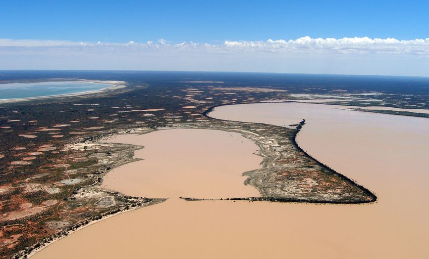
6Figure 5. Currawinya contains a diverse range of wetlands including the large semi-permanent freshwater Lake Numalla (foreground), saline Lake Wyara (top left) and a
complex of differing claypans. © Mark Handley 2008
Figure 6. Artesian mound or mud springs. © Stephen Peck 2012
Currawinya National Park Resource Information
Draft for consultation
7Figure 7. Artesian vegetated water spring (Massey Springs). © Stephen Peck 2012
Figure 8. Artesian un-vegetated water spring (Poached Egg Spring). © Stephen Peck 2012
Currawinya National Park Resource Information
Draft for consultation
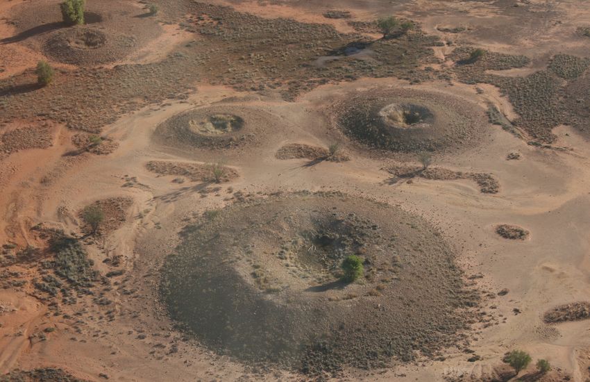
82.2.6 Artesian springs 2.3 Ecosystems services
Currawinya National Park contains a large number of artesian
springs belonging to the Eulo supergroup (Fensham & Fairfax 2.3.1 Aesthetic values
2003). These natural discharge springs of the Eulo area (RE
The Australian outback is renowned for its open space and
6.3.23) are often associated with granite intrusion, RE 6.12.1
desolate natural beauty. In the midst of a vast harsh semi-arid
(Queensland Herbarium 2018). Currawinya contains excellent
environment that’s dominated by extensive sandplains and
examples of both mound (mud springs) (Figure 6) and water
rocky residual ranges, the Currawinya’s lakes, river and wetlands
springs, vegetated (Figure 7) and un-vegetated (Figure 8).
provide areas of stark visual contrast. The area’s tranquillity and
Artesian springs are listed as an endangered ecological great natural beauty is an aesthetic that is not common in the
community under the EPBC and are an important value of this region.
park. They provide habitat for a number of endemic species
and isolated populations of both flora and fauna (Appendix 3).
Protection of artesian springs and associated endangered and
endemic species are listed as a priority for conservation in the
Mulga Lands (Fensham et al. 2007).
These springs, especially the category 1 and 2 springs, are
of very high state and national priority for their inclusion in
the protected area estate. The northern section of the park
contains areas of active and inactive springs, which are highly
significant for conservation. So too are the vegetated springs
on the 2015 acquisition area that include the Massey Spring
complex (Category 1a), Tunga Springs (Category 1a), Granite
Springs (Category 2/3), Fish Springs complex (Category 2/3) and
Little Granite Springs (Category 2/3). Conservation-significant
species of these spring groups include Eragrostis fenshamii
(endangered), Myriophyllum artesium (endangered), Hydrocotyle
dipleura (vulnerable), Calocephalus glabratus (vulnerable)
(Figure 9) and an endemic snail, Jardinella eulo (no conservation
listing).
The Eulo springs supergroup is one of the most degraded spring
groups in Queensland. Water drawdown, excavation of springs Figure 9. Calcephalus glabratus is a vulnerable species endemic to the Eulo springs
supergroup. Its only protected area representation is Currawinya National Park and
to increase water storage, domestic stock and feral animal use it has been recorded at Fish, Wedgie, Boomerang, Poached Egg and Basin Bore
all pose significant threats to these springs (Peck & D’Souza Springs, and several other unnamed spring groups. © Stephen Peck 2013
2016; Fensham et al. 2007). While Silcock et al. (2013) found
that only 57 per cent of the Eulo spring supergroup is currently
active, some of these springs may have become inactive before
European settlement; they are referred to as fossil springs.
A limited amount of survey work has taken place on Werewilka
and Oolamon, mostly in relation to the artesian springs’ work by
the Queensland Herbarium and local Charleville QPWS staff. In
2012, QPWS began monitoring at Boorara to document changes
in vegetation after the property was destocked, and to keep a
record of the property’s transition from a grazing property to a
protected area.
Currawinya National Park Resource Information
Draft for consultation
92.4 Species
2.4.1 Native animals Lakes Wyara and Numalla are of particular importance in the
conservation of waterbirds, as they provide a major breeding
Currawinya has a rich array of native animals including 16 habitat and are an important refuge during drought periods. This
species of frog, 226 species of bird, 36 species of mammal is particularly so for one of Australia’s rarest ducks, the freckled
(eight introduced species and 28 native species), 12 species duck Stictonetta naevosa (Kingsford & Porter 1999).
of fish (three introduced species and nine native species) and Flood-produced plant growth is also an important food source
56 species of reptile. While many of the recorded species are for many species of birds that are not waterbirds. Currawinya
typical of the Mulga Lands Biogeographic Region, some species also contains suitable habitat for a number of species that
are partly or totally dependent on the unique habitat types are uncommonly recorded within Queensland. Banded stilts
represented within the park. Eleven of the fauna species are of Cladorhynchus leucocephalus, white-fronted chats Epthianura
conservation significance; six birds, two mammals, two fish and albifrons, bluewinged parrots Neophema chrysostoma and
one reptile (Appendix 3). chestnut teal Anas castanea, all predominantly southern species,
have been recorded in the park.
As many as 100 000 waterbirds visit (at one time) and rely on the
Currawinya National Park’s wetlands, making it one of Australia’s Through a reintroduction program within a feral animal-proof
most important inland wetland habitats. Some birds migrate fence, QPWS seeks to establish a viable population of the greater
from as far afield as China, Japan and South Korea, and as such bilby Macrotis lagotis.
are listed in the Japan–Australia, China–Australia Migratory Bird
and Republic of Korea–Australia Migratory Bird agreements and
the Convention on the Conservation of Migratory Species of Wild
Animals (Appendix 4).
Figure 10. Smooth knob-tailed gecko Nephrurus levis, Yarraman Springs. © Stephen Peck 2013
Currawinya National Park Resource Information
Draft for consultation
102.4.2 Native plants Currawinya’s northern section contains relatively large areas
of regional ecosystem that are either listed as ‘of concern’
More than 500 species of plants have been recorded within or have low protected area representation. This includes an
Currawinya National Park, including two species listed as extensive area of mulga/poplar box tall open shrublands on sand
‘endangered’ and four listed as ‘vulnerable’ under the NCA. A plains, which supports a population of the ‘vulnerable’ Acacia
further four species are listed as ‘vulnerable’ under the EPBC ammophila, only known in two other parks. The stony crest and
(Appendix 3). Other noteworthy plant species include mature, tops and the slopes support large areas of bastard mulga and
relatively undisturbed communities of yapunyah E. ochrophloia gidgee shrublands, respectively. The major drainage channels
and turpentine mulga A. brachystachya. These communities are support extensive areas of river red gum woodlands, known for
at the centre of their distribution in Queensland and have been their high fauna diversity.
described by Purdie (1985) as representing the peak development
of these species in the state. Several species are at the extremes Two species, black bluebush Maireana pyramidata and inland
of their natural distribution (Figure 11). belah Casuarina cristata paupe, are far beyond their current main
ranges of distribution and are extremely rare in Queensland.
While mulga-dominated communities prevail, Currawinya National These populations may be relic communities or may represent
Park has significant areas of shrubland communities, particularly the rare occurrences in Queensland of habitats suitable for these
samphires Halosarcia spp., budda Eremophila sturtii and belalie plants (Purdie 1985). Belah Casuarina cristata also occurs in
Acacia stenophylla, and sedgeland communities, dominated by small patches and is at its western limit of distribution.
pinrush Cyperus gymnocaulos. These communities are uncommon
in Queensland because of their habitat requirements (Gasteen Swamp paperbark Melaleuca densispicata, an uncommon shrub
1985). whose range is restricted to a small area of southern Queensland
and northern New South Wales, occurs in groves on the lower
slopes of dunes near saltpans and claypans.
Scientific names Common name Extent of distribution in Queensland
Eucalyptus largiflorens Black box Northern inland continental limit and western limit
Eucalyptus populnea Poplar box Western limit
Acacia petraea Lancewood South-western limit, restricted to the Mulga Lands Biogeographic Region
Flindersia maculosa Leopardwood South-western limit
Geijera parviflora Wilga Extreme western limit
Figure 11. Species that occur at the extreme of their natural distribution
Currawinya National Park Resource Information
Draft for consultation
112.5 Geophysical features
2.5.1 Rangeland landscapes Paroo River is the largest watercourse flowing through the park.
Its large catchment forms part of the headwaters of the Murray–
Currawinya contains an array of unique semi-arid landscapes Darling Basin. Although the area is usually dry, flooding is not
centred on the Hoods and Willies ranges, with dissected uncommon and can occur without rain falling in the immediate
tablelands, rugged hills and scarps that run down to a diverse area. Major flows in the Paroo back up into Lake Numalla, adding
wetland system of permanent, semi-permanent and ephemeral nutrients to the largely self-sustaining system. Many semi-
lakes. These lakes drain through an extensive aeolian sandplain permanent waterholes fill en route to the lake.
system, dominated by mulga associations, into the channels of
the Paroo River. The landscape of the northern section of the park is very different
to the red earth, soft mulga dominated and wetland landscapes
The two major lakes, Wyara and Numalla, provide the most of the south. There’s extensive areas of hard stony plains, stony
distinctive landscape features associated with the park. crests and the tops of residual country. These ancient eroded
Freshwater Lake Numalla (2904 ha) is mostly surrounded by ranges provide the upper catchment for lakes Wyara and Numalla
sandy beaches, fringed by Cyperus gymnocaulos sedgelands and, in good seasons, rapidly respond to provide significant
leading up to black box and belalie low open woodlands. It wildlife corridors in an otherwise waterless landscape. The
is surrounded by extensive dunefields and sandplains, the visual appeal of the landscape has, to date, been unmarked by
tranquillity of the lake’s edge providing a welcome visual and infrastructure development or damaging visitors impacts.
sensory contrast to the surrounding semi-arid landscapes.
The clear blue-green saline water of Lake Wyara (3813 ha) is
reminiscent of an inland sea. Dense low samphire shrublands
2.5.2 Soils
cover relict beaches, with little tall vegetation in sight. This vista The soils of the Mulga Lands are considered particularly fragile.
creates a great sense of space and openness, with Mt Roy to the Soils are characterised by low levels of nutrients and organic
west the only relief. Currawinya’s other smaller lakes, including matter, a large proportion of which is in the immediate topsoil
Kaponyee, Yumberrara and Karatta, are surrounded by distinct (Walker & Fogarty 1986). Loss of topsoil through wind and water
vegetation and have their own character. erosion may significantly affect the delicate balance of nutrient
cycling in these areas.
A significant seam of granite runs north-south through
Currawinya, only reaching the surface at a few localised sites Since domestic grazing stock has been removed from the park,
in south-west Queensland. One such place is north-east of lower stratum vegetation has become more abundant. Vegetation
Hungerford in the upper reaches of Twomanee Creek. Locally removal by overgrazing exposes the soil surface to erosion,
known as The Granites, the view from the summit at the southern leading to soil loss and reduction in soil fertility (Miles 1993).
end of Hood Range extends over the park to the horizon, taking Wind erosion is potentially worse than water erosion because
in several different land systems. Several spring complexes wind-eroded sediments are rich in nutrients (Miles 1993). Thus,
are directly associated with this granite outcropping and wind erosion leads to a greater decline in soil productivity. The
thought to have resulted from the contact between on-lapping maintenance of groundcover is essential for maintaining the
sediments and the outcropping basement structure (Wolhuter nutrient-cycling process.
et al. 2014). Being unique features of the arid Australian
landscape, artesian springs are of considerable limnological Rehabilitation of degraded sites is being undertaken. Current
and geological significance, providing researchers with an and future rehabilitation efforts need to focus on eroded areas,
opportunity to undertake a variety of evolutionary, ecological and washouts (e.g. along internal fence lines and roads or tracks),
biogeographical studies. weed-infested areas and areas disturbed or compacted by feral
animals.
The Paroo River’s waterholes, edged by river red gums and
coolabah, provide scenic and tranquil spots for visitors. The
Currawinya National Park Resource Information
Draft for consultation
122.6 Recreational opportunities 2.7 Ecotourism
2.6.1 Camping 2.7.1 Tourism and visitor opportunities
Currawinya has four camping areas: Ourimperee Waterhole, Corni Straddling major roads leading to Cunnamulla, and to Bourke
Paroo Waterhole, Caiwarro Waterhole and Pump Hole. and Wilcannia in New South Wales, Currawinya National Park
is becoming a major tourist attraction in the Eulo–Hungerford–
Thargomindah area. The remote and arid landscape of south-
2.6.2 Day-use areas
western Queensland has contributed to the popularity of
Several day-use areas provide picnic tables, toilets and protected areas within the region.
interpretative materials. These are located at Currawinya’s ranger
base, Currawinya Woolshed, Old Caiwarro Homestead site, The Annually, about 2000 visitors come to Currawinya National Park
Granites, Lake Numalla and Lake Wyara lookout. to experience an outback setting where they can pursue nature-
based recreation activities such as camping, bushwalking, nature
observation (particularly birdwatching) and nature photography.
The park provides visitors with a sense of adventure in a
reasonably remote area.
Visitor numbers to south-western Queensland are steadily
increasing. In 1994–95, 208 000 Australian visitors were
attracted to the western Queensland area, with 78 000 of
these visiting south-western Queensland. An additional 3000
international visitors were recorded during the same period
(Queensland Tourist and Travel Corporation, January 1996).
Outback Queensland tourism data, which includes south-
western Queensland, shows that domestic visitation to the
region increased by 9.7 per cent in 2017, recording 878 000
visitors with an estimated expenditure of $584.8 million (Tourism
& Events Queensland 2017).
Visitation to Currawinya National Park is likely to increase, further
supplementing the economies of local rural centres located
en route to the park, such as Hungerford, Eulo, Thargomindah,
Bourke and Cunnamulla. Expenditure in the local communities is
likely to be for accommodation, transport, food and beverages,
shopping and other incidentals.
Currawinya National Park Resource Information
Draft for consultation
132.8 Historic cultural heritage
2.8.1 Pastoral history One of the earlier grazing families of Boorara is remembered
through the graves that are located on the property. The
Currawinya National Park incorporates the areas of five former earliest graves are for Frederick Holm (44 years) who died on
pastoral properties: Currawinya, Caiwarro, Boorara, Werewilka 26 November 1892 and his daughter Mary Holm (16 years) who
(Werewilka and Granite Springs) and Oolamon, which was part of died in 1891. Other graves are located in various areas of the
Bingara. property.
Currawinya was first occupied for pastoral use in 1865, and
Caiwarro in 1864. In 1924, the two properties were amalgamated
under the Paroo Pastoral Company, although they continued
to be managed as separate units. Caiwarro Homestead was
abandoned and demolished in 1971. Management was moved
to Currawinya Homestead, and the two leases were formally
amalgamated as Currawinya in 1974. While little remains of the
homestead complex at Caiwarro, the site offers the opportunity
to examine the layout of the homestead area and surrounding
yards. This reflects past social stratification among managers,
jackeroos, stockmen and servants on properties. The Caiwarro
ruins also present an opportunity to observe construction
techniques of the time (1890s), most notably the brick and
pisé construction that was common in the area. Throughout the
park, relics of sheep yards and fencing remain, demonstrating
early settlers’ pastoral practices and building techniques. A
small amount of old machinery, such as the pump used to draw
water from the Paroo River to irrigate a fodder-growing area
on Caiwarro, remains on the park and is of cultural heritage
significance.
Boorara, Werewilka and Oolamon, added to the national park in
2015, were grazing properties from the mid-1800s. Extensive
evidence remains across the properties in the form of building
ruins, gardening and grazing areas, shearing sheds and quarters,
machinery associated with shearing and pastoral industries and
the development of suitable stock and domestic water supplies.
The original Boorara Homestead (c1880) provides an excellent Figure 12. Tareen Mill, Currawinya National Park. © Stephen Peck 2012
example of brick and pisé construction, which was a commonly
used construction technique of the area in the late 1800s.
There is an extensive network of infrastructure including roads,
dams, bores, fences, buildings and landscape. Of the numerous
historical sites and artefacts on the property, some sites such as
timber-lined spring wells on Boorara and Werewilka, represent
significant or unique examples of the area’s grazing history. Other
examples of the pastoral history are listed in Appendix 5.
Currawinya National Park Resource Information
Draft for consultation
142.9 Partnerships 2.11 Education
A strong working partnership will be developed between QPWS National parks offer visitors not only the chance to enjoy nature-
and the Budjiti Aboriginal Corporation under a signed Protected based recreational activities, but also an opportunity to gain
Area ILUA. knowledge of the native plants and animals and the natural
processes associated with a region.
QPWS has a strong working relationship with the Save the Bilby
fund for the ongoing management of the bilby enclosure. Currawinya provides an ideal natural resource for formal and
informal education. School groups, tertiary institutions, local
community members and interest groups can use the park to
2.10 Scientific research study the processes associated with inland wetland systems,
other characteristic semi-arid landforms, and native plant
and native animal ecology, particularly that of waterbirds and
The diversity of landforms and vegetation types within Currawinya
macropods.
National Park provides the area with a high potential for the
development of reference sites that will aid the management of
Public appreciation of the cultural importance of the area can
pastoral properties in the area. The provision of information on
be increased by reference to historical pastoral activities and
pasture condition and trend in the absence of domestic stock and
acknowledging the importance of the Budjiti cultural landscape
on trends in populations of the dominant tree and shrub species
and culture places associated with areas such as the artesian
may have broad-scale land management implications.
springs and ‘The Granites’.
The park offers opportunities for research into geomorphological
processes associated with inland lake systems, the ecology
of native bird species, particularly waterbirds, and the general
ecology of inland lakes and mulga communities. Research that
is carried out on Currawinya National Park can also support its
management.
Currawinya contains a number of long-term enclosure plots, some
of which were established when the park was gazetted. These
plots provide excellent information on the changes in vegetation
as they transition from grazing property to protected area, and the
effectiveness of park management.
Currawinya National Park Resource Information
Draft for consultation
152.12 Fire 2.13 Pests
To date, fire management has had a low priority on Currawinya 2.13.1 Pest plants
National Park. Due to the high variability of seasonal conditions
and the impacts of past grazing pressure on groundcover, the A number of environmental weeds have the potential to
occurrence of fire, in the short term, is unlikely. In the absence of significantly impact the values of the park. These include buffel
grazing, however, groundcover biomass is likely to increase, and grass Cenchrus ciliaris, Noogoora burr Xanthium occidentale,
fire management will assume a greater importance. Mexican poppy Argemone orchroleuca, saffron thistle Carthamus
lanatus, Bathurst burr Xanthium spinosum, spiny emex Emex
A wildfire response procedure has been compiled for Currawinya australis, sesbania pea Sesbania cannabina var.cannabina,
National Park. Firebreaks protect park infrastructure and visitor African boxthorn Lycium ferocissimum and downy thorn apple
safety, and play an important part in preventing the movement Datura inoxia. As many of these species are already established,
of fires in to and out of the park. They also provide a means of management should focus on targeting infestation impacting on
access to fight fires and impede or block the progress of fires. The the key values of the park (Appendix 6).
firebreak network currently reflects the tracks and roads within
Currawinya. Future requirements are being examined. Buffel grass has the potential to become a serious environmental
weed of protected areas, especially those in the semi-arid areas.
Fire regimes and fire parameters for Currawinya National Park will Buffel grass forms dense monocultures, outcompeting native
be based on those identified in the Planned Burn Guidelines – species and altering fire regimes. Eradication is highly unlikely;
Mulga Lands Bioregion of Queensland (Department of National management zones may be required to reduce its impacts on the
Parks, Recreation, Sport and Racing 2013). values of the park.
A draft zoning scheme has been developed for the park. While Annual beard-grass Polypogon monspeliensis has been identified
gas fires are allowed in all visitor access zones, the use of wood as an emerging weed of significance of spring wetlands in South
fires is limited to the recreation zone only. Fire is likely to be Australia. There is an unconfirmed record of annual beard-grass
a potential hazard under certain circumstances and fire ban from Tunga Springs (R Fensham pers. comm.). Given the potential
regulations may need to be imposed at particular times. Zone impacts of this weed on the high conservation value artesian
objectives will dictate the types of burns conducted by park staff spring, ongoing monitoring is required to ensure the species
(e.g. hazard reduction or ecological) and the policies adopted to does not become established.
control natural fires (e.g. ‘let burn’, ‘suppress’ or ‘manipulate’)
in individual zone categories. Signs stating that firewood should Athol pine Tamarix aphylla is present at most of the homesteads
only be collected from roadsides have been placed at the and outstations on the new acquisition properties. Salt-tolerant,
northern and southern entrances to the park, along the Eulo– it can reproduce by seeds or suckering, forming dense thickets
Hungerford Road (a gazetted road). especially along water courses. Ongoing monitoring is required.
Mulga Acacia aneura is a dominant component of many Rope cactus Cylindropuntia sp. is a serious environmental weed,
vegetation communities across the park and, as such, is currently restricted to a small area around the Corina homestead.
considered a key indicator species for fire management. Mulga Eradication of this infestation is possible.
is considered a fire-sensitive species (Silcock et al. 2017;
Wright et al. 2015; Hodgkinson et al. 1984; Morrisey 1984) Parkinsonia Parkinsonia aculeata has the potential to seriously
and an obligate seed regenerator (Hodgkinson & Oxley 1990). impact the values of the lakes, wetlands, springs and riparian
Hodgkinson (2002) explains that acacia-dominated ecological zones. Parkinsonia has been recorded on the Paroo River
systems and the organisms that comprise them have evolved upstream from the park. A small infestation around the Corina
with various disturbance events including fire. Both mature and homestead has been treated. With ongoing management, it
seedling mulga plants may be killed by a fire event although should be possible to eradicate Parkinsonia from the park.
the proportion of adult plants killed varies widely, depending
Priority should be given to preventing the establishment of new
on factors such as weather conditions, water stress, fuel loads
weed species. Priority areas include the Hungerford Road, which
and distributions, and fire intensity. Regeneration of mulga
runs through the park and includes traffic entering Queensland
plants following a high-intensity fire is by seeds stored in the soil
from New South Wales and at camping grounds.
surface (Hodgkinson & Oxley 1990).
Currawinya National Park Resource Information
Draft for consultation
162.13.2 Pest animals House mice Mus musculus are present mainly around the
occupied homestead areas. They do not present a significant
Eight terrestrial vertebrate pests, including feral pig Sus scrofa, hazard to park ecology at present. Standard methods of control
feral goat Capra hircus, horse Equus caballus, fox Vulpes vulpes, (e.g. traps) are used.
feral cat Felis catus, European rabbit Oryctolagus cuniculus,
house mouse Mus musculus and domestic and feral cattle Bos Beekeeping is a major primary industry in the area. Apiary sites
taurus/Bos indicus, and three introduced fish, European carp are located on the road reserves that traverse the park. While
Carassius auratus, gold fish Cyprinus capio and mosquito fish the influence of the introduced honeybee on native animals and
Gambusia holbrooki, are currently established on Currawinya plants is not well understood, it has been suggested that nectar
(Appendix 6). extraction behaviour by bees may damage flowers and fail to
pollinate various species of native plants. Although apiculture
The foraging behaviour of feral pigs, digging for roots and tubers is considered an extractive industry and is thus incompatible
of plants in soft soil and mud, can cause extensive damage. with the management philosophy of national parks, QPWS has
Feral pigs have been known to destroy the nests of both aquatic no control over the conduct of beekeeping on adjacent private
and ground-dwelling birds while raiding them for eggs. This is lands.
particularly significant on Lake Wyara when water levels are low
and pigs and other carnivores, such as foxes and cats, have easy
access to breeding colonies on the lake’s former islands.
Since 2008, QPWS has used external contractors to remove feral
goats from Currawinya. Under the terms of the contract, goats
are mustered, yarded and trucked by the successful tenderer.
Although the contract process has been successful in removing
large numbers of goats from the park, the process requires
regular reviews to ensure and improve its effectiveness in
achieving the overall management objectives.
Feral cats F. catus have been identified as a threatening process
of the ‘endangered’ greater bilby Macrotis lagotis. Feral cats
re-established in the bilby enclosure after 2010 floods, causing
a significant decline in the bilby population inside the bilby
enclosure.
Mosquito fish G. holbrooki are established in the Paroo
River and at numerous artificial water points. Mosquito fish
represent a serious threat to the endemic fauna of artesian
springs and wetlands. Ongoing monitoring is required to ensure
that mosquito fish do not become established in the high
conservation springs of Currawinya. This includes monitoring
artificial and ephemeral water points adjacent to the springs.
European carp and goldfish are well established in the Paroo
River system and are thought to be an important component of
the waterbird diet of the region. European carp are classified as
a ‘noxious fish’ under the Fisheries Act 1994 (Qld) and, if caught,
must be destroyed (and not returned to the water) under the
provisions of that Act.
Currawinya National Park Resource Information
Draft for consultation
17You can also read