D2 Background to Airspace Architecture - VOLUME D: AIRSPACE - Brisbane Airport
←
→
Page content transcription
If your browser does not render page correctly, please read the page content below
VOLUME D: AIRSPACE

D2   Background to Airspace Architecture

            NEW PARALLEL RUNWAY DRAFT EIS/MDP
                                                D2-5
                   FOR PUBLIC COMMENT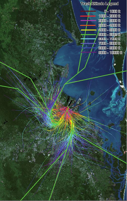
VOLUME D: AIRSPACE

       D2                 Background to Airspace Architecture

       CONTENTS                                          FIGURES AND TABLES

       2.1 Introduction                            7     Figures

       2.2 Weather                                 7     Figure 2.2a: Existing Runway Configuration 2005

           2.2.1 Wind Direction                    7     Figure 2.2b: Crosswind and Downwind on Runway
                                                                      01/19 for a 25 Knot North-Easterly
           2.2.2 Wind Speed                        9
                                                         Figure 2.3a: Runway 01 Jet Aircraft Departures
           2.2.3 Rain                              9                  January 2005
           2.2.4 Visibility                        10    Figure 2.3b: Runway 01 Jet Aircraft Arrivals
                                                                      January 2005
       2.3 Flight Paths                            10
                                                         Figure 2.3c: Runway 19 Jet Aircraft Departures
       2.4 Airport Operating Hours                 15                 January 2005
       2.5 Volume of Aircraft Traffic               15    Figure 2.3d: Runway 19 Jet Aircraft Arrivals
                                                                      January 2005
       2.6 Air Traffic Control Procedures
           for Brisbane Airport                    16    Figure 2.6a: Extracts of Section 4.5 of AsA AIP
                                                                      ENR 1.1.4.5
           2.6.1 Weather Criteria for Visual
                 or Instrument Landings            16    Figure 2.6b: Extracts of Section 11.5 of AsA AIP
                                                                      ENR 1.1.4.5
           2.6.2 Nominating Duty Runways           16
                                                         Figure 2.7a: Existing Runway System and Modes
           2.6.3 Sequencing of Arriving Aircraft   17
                                                         Figure 2.8a: Relationship between ANEF and
           2.6.4 Noise Abatement                                      Proportion of People ‘Seriously
                 Procedures (NAP)                  17                 Affected’ by Aircraft Noise (from
           2.6.5 Approach Requirements             18                 Australian Standard 2021)

       2.7 Runway Modes of Operation               19    Tables
           2.7.1 Current Operating Modes           19    Table 2.6a: Minimum Current ATC Time Separation
                                                                     for Sequencing of Arrivals
           2.7.2 Mode Capacity                     19
                                                         Table 2.8: Building Land Use Compatability Advice
           2.7.3 Rules for Mode Selection –
                                                                    for Areas in the Vicinity of Airports
                 ‘Active’ versus ‘Passive’         21

       2.8 Noise Descriptors                       21
           2.8.1 ANEF and ANEC Contours            21
           2.8.2 N70 Contours                      22
           2.8.3 Flight Path Movement Charts
                 and Respite Charts                24
           2.8.4 Single Event Contours             24

                                       NEW PARALLEL RUNWAY DRAFT EIS/MDP
D2-6                                          FOR PUBLIC COMMENT
VOLUME D: AIRSPACE

D2                 Background to Airspace Architecture

2.1      Introduction                                        •   Modes of operation (different combinations of
                                                                 runway direction and operating rules); and

The Brisbane Airport New Parallel Runway (NPR)               •   Mode capacity (the maximum number of
project involves construction of a new runway                    aircraft per hour which can be processed in a
3,600 m long and 2,000 m to the west of the                      particular mode).
existing main runway. As part of the project, the            This Chapter also provides a summary of the
existing cross runway would be strengthened and              ways in which aircraft noise can be described, and
converted into a taxiway.                                    introduces measures of aircraft noise exposure
This project would result in changes to the pattern of       which are used in subsequent sections to describe
aircraft noise around Brisbane Airport, due to required      and compare noise impacts under various scenarios.
alterations to aircraft flight paths and airport operating
modes. The changes would result in lower noise               2.2      Weather
impacts in some areas, and higher noise impacts in
others. In addition, projected future growth in air traffic
                                                             Weather patterns heavily influence airport operations
will result in increased numbers of operations at the
                                                             on an hourly, daily and seasonal basis. There are a
airport, with or without the NPR project, although this
                                                             number of ways weather affects aircraft operations.
will be mitigated to some extent by the introduction
                                                             They are as follows:
of new, quieter aircraft and improvements in air traffic
navigation technology and procedures.                        •   Wind direction and speed, which dictate the
                                                                 direction of the operating (duty) runways (i.e. the
This Chapter provides background information on
                                                                 direction from which aircraft can land or take-off);
the issues and concepts that relate to airspace
operations to assist the reader in understanding the         •   Whether it is raining or not (wet or dry). Different
noise impacts associated with the NPR. Outlining                 operating rules are invoked if the runway is wet; and
an explanation of these factors at the outset
                                                             •   Visibility due to fog or height of the cloud base.
provides the basis for the discussions regarding                 This determines whether certain flight paths and
flight paths and noise implications that follow in                operating rules are used or not.
Chapters D3, D4 and D5.
                                                             2.2.1    Wind Direction
Airspace operations at Brisbane Airport are
influenced by a range of factors. These include               As a general aviation rule, the safest and most
daily, weekly and seasonal variations in weather, and        efficient way for aircraft to operate is for all
in the number of aircraft arriving and departing, as         departures and arrivals to be conducted into the
well as their points of origin or destination. Longer        wind. A runway can be used in two directions, so
term factors like growth in total traffic volumes and         wind direction is important to an airport for three
the introduction of new aircraft or new technologies         main reasons:
also affect operations. It is important to understand
how each factor can influence how an aircraft may             1. It influences the selection of the alignment of the
                                                                runways when they are originally built;
be directed to operate on a given day. The following
factors play an important role in airspace operations        2. It affects the direction in which the runways will
and are discussed in detail in the sections below:              be used for arrivals and departures at any given
                                                                time; and
•   Weather;
                                                             3. If the conditions are too dangerous the airport
•   Aircraft flight paths;
                                                                will be closed.
•   Airport operating hours;

•   Volume of aircraft traffic;

•   Air Traffic Control procedures;

                                    NEW PARALLEL RUNWAY DRAFT EIS/MDP
                                           FOR PUBLIC COMMENT                                                            D2-7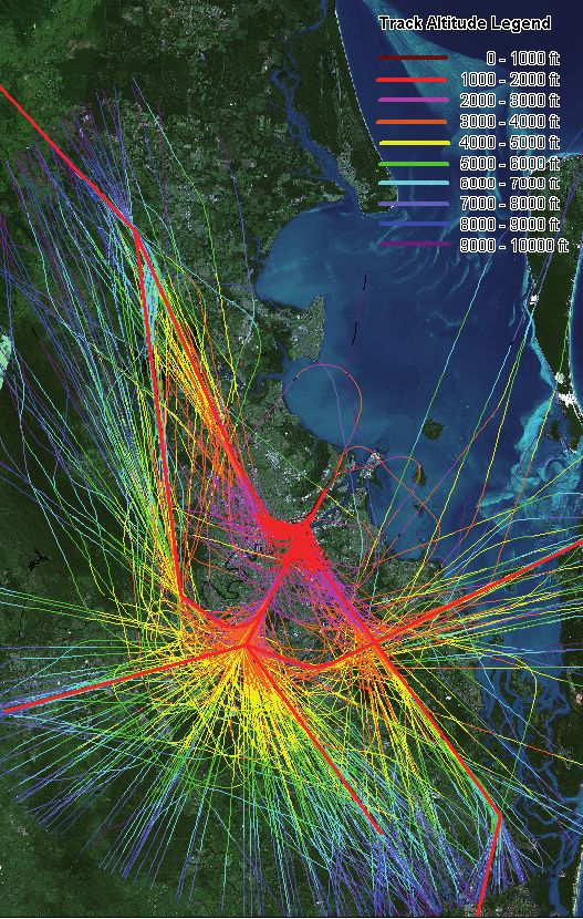
At Brisbane Airport, meteorological information                      Runways can operate in both directions. As noted
       has been collected for many years by both the                        previously, Brisbane’s main runway is positioned in
       Bureau of Meteorology and Airservices Australia                      a north-south alignment, such that arrivals on the
       (AsA). Consequently, wind speed and direction is                     main runway can land from the south over
       well understood. Chapters D4, D5 and D6 provide                      Brisbane and departures take off to the north over
       additional detailed discussions of relevant weather                  Moreton Bay or vice versa. The current runway
       conditions at Brisbane Airport.                                      layout is shown in Figure 2.2a.

       In summary, the wind patterns at Brisbane Airport                    The modes of runway operation are discussed in
       are characterised by distinct seasonal patterns. In                  more detail in section D2.7. In summary, when
       summer the winds at the Airport are predominantly                    wind is from a northerly direction (typical summer
       north to north-easterly or south-easterly, while                     conditions) the 01 runway direction is used with
       in winter they are predominantly from a south to                     aircraft arriving from the south over Brisbane
       south-westerly direction. This generally north-south                 and taking off to the north over Moreton Bay.
       pattern of winds would have been an important                        Conversely, when the wind is from a southerly
       consideration for the current alignment of the                       direction (typical winter conditions) the runway is
       existing airport runways and proposed NPR.                           used in the 19 direction with aircraft arriving from the
                                                                            north over Moreton Bay and taking off to the south
                                                                            over Brisbane.

       Figure 2.2a: Existing Runway Configuration 2005.

                                                                                                                                            N

                                                                                                                               14
                                                                                                                                       MORETON BAY
                                                                                                                             S
                                                                                                                          RE
                                                                                                                          S
                                                                                                                        RE

                                                                                                                       TU
                                                                                                                   EP LS
                                                                                                                     AR
                                                                                                                     TU

                                                                                                               D D IVA
                                                                                                                 EP LS
                                                                                                                   AR
                                                                                                            D D IVA

                                                                                                            AN RR
                                                                                                          AN ARR

                                                                                                                 A
                                                                                                              14
                                                                                                           32

                                                          01 ARRIVALS
                                                          AND DEPARTURES                                      32
                                                                                                         19
                                       01

                                                                    19 ARRIVALS
                                                                    AND DEPARTURES

       Note: Runways are generally numbered according to the magnetic direction in which they point, rounded to the nearest ten degrees and
       then divided by ten. Each digit is pronounced separately for clarity in radio communications. For example, at Brisbane Runway Zero
       One (01) would be aligned in roughly a 10-degree direction (i.e. close to magnetic north), and Runway One Nine (19) would be used for
       a runway with a 190-degree alignment (i.e. close to magnetic south).

                                                NEW PARALLEL RUNWAY DRAFT EIS/MDP
D2-8
                                                       FOR PUBLIC COMMENT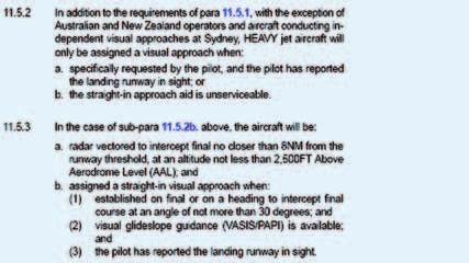
2.2.2   Wind Speed                                                            At Brisbane Airport wind speeds fluctuate widely,
                                                                              but generally winds are stronger during daylight
Wind at an airport is most commonly described                                 hours and in the early evenings. As the ground
in its crosswind and downwind components.                                     temperature cools, local wind speeds generally
The crosswind component of wind is the vector                                 are observed to decrease. This is important when
component of wind that blows perpendicular                                    determining the use of a particular runway direction
(at right angles) to the runway it refers to. The                             or mode of operation (see section D2.7). For
downwind component is the vector component of                                 example, noise over residential areas of Brisbane is
wind that blows parallel (in line) with the runway it                         minimised when both arrivals and departures take
refers to. By way of example, the crosswind and                               place over Moreton Bay, but this is possible only
downwind components on the main runway 01/19                                  when wind conditions allow operations in both a
for a 25 knot north-easterly is shown in Figure 2.2b.                         northerly (01) and a southerly (19) direction.
Under these conditions the downwind component
is 20.5 knots and the crosswind component is                                  2.2.3   Rain
14.3 knots and the main operating (duty) runway
would be runway 01.                                                           The operating rules for aircraft change if it has
                                                                              been raining (even very lightly) and the runway is
Wind speed is important because in low downwind                               considered ‘wet’ rather than ‘dry’. With a ‘wet’
speed conditions – typically less than 5 knots                                runway, safety considerations generally dictate
(~10 km/hr), aircraft may be able to safely land and                          that no tailwind is allowed for any operations, and
take-off even with the wind blowing from behind,                              this restricts the potential to apply certain Noise
referred to as a tail wind.                                                   Abatement Procedures, as explained in more detail
                                                                              in section D2.7.

Figure 2.2b: Crosswind and Downwind on Runway 01/19 for a 25 Knot North-Easterly.

  North
                        Moreton Bay
          14                                                                       35 degrees

          Cross                         19                   North-easterly
          Runway                                               25 knots
          14/32
                                             32                                                 downwind
                                                                                                20.5 knots
                                  /19
                             ay 01
                         Runw
                    Main

                                                              crosswind
                   01                                         14.3 knots

        Brisbane (over land)

                                                  NEW PARALLEL RUNWAY DRAFT EIS/MDP
                                                                                                                                     D2-9
                                                         FOR PUBLIC COMMENT
2.2.4 Visibility All SIDs and STARs which relate to Brisbane Airport
are published as part of Airservices Australia’s
Good weather, clear skies and little or no cloud Aeronautical Information Package (AIP) and
cover presents the optimum conditions for aircraft are contained in the Departure and Approach
operations. When weather conditions are not good Procedures (DAP East) available at http://www.
and the human eye cannot be relied upon for visual airservicesaustralia.com/publications/aip.ais. They
cues to avoid terrain obstacles or other aircraft, or are also discussed in more detail in Chapter D3.
see the runway, pilots are required to fly either on a
different flight path or with different flight rules. While flight paths are often depicted as single lines
on a map, it is not possible for all aircraft following
In controlled airspace like that surrounding a particular flight path to fly precisely along the
Brisbane Airport, Air Traffic Control (ATC) same line. In practice, individual flight paths tend to
determines, based on the presenting weather occur within flight corridors that can be a number of
conditions, whether ‘visual’ or ‘instrument’ kilometres wide. The SIDs and STARs are followed
conditions apply and hence whether instrument or most closely under ‘instrument’ weather conditions.
visual flight rules apply. The standards for triggering Under ‘visual’ conditions aircraft may be given
when instrument over visual conditions apply are alternative instructions, known as ‘vectoring’, which
set by the recognised international body ICAO and may allow the aircraft to shortcut the SID or STAR
is prescribed in relevant AsA publications to which to achieve more efficient sequencing of aircraft
all pilots and airlines refer. The determination for arrivals and departures. In addition, variation in wind
instrument or visual conditions at Brisbane Airport is conditions affects the exact flight path followed. For
monitored continuously by ATC and set accordingly. example, wind affects the rate at which departing
aircraft climb, and hence the point at which a turn
2.3 Flight Paths may be executed.
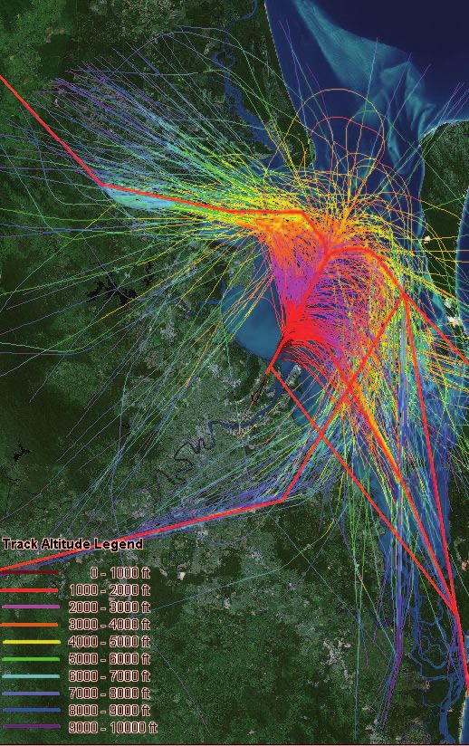
Figures 2.3a to 2.3d show typical individual flight
Flight paths are the highways in the sky. They are tracks for jet aircraft arriving and departing on
three-dimensional tracks that provide pilots with runway 01 and runway 19 at Brisbane Airport,
the signposting to allow them to safely fly between recorded during the month of January 2005. The
destinations and to land and take-off from airports. altitude of the aircraft is represented in the figures by
Ideally, aircraft fly by the most direct route and at coloured bands.
the optimum altitude for reasons of economy and The plotted flight tracks were provided by
efficiency of flight operations. However, it is not Airservices Australia’s Noise and Flight Path
always possible for aircraft to fly optimum routes Monitoring System (NFPMS) installed at Brisbane.
because of safety considerations, the competing The NFPMS records flight paths to 30 nautical miles
demands of other airspace users, and noise from the airport, for aircraft at or below an altitude of
abatement considerations. 10,000 ft above ground level or mean sea level.
In order to achieve safe segregation of aircraft, and Movements and noise data recorded by the NFPMS
being mindful of the noise effects on the community, at Brisbane Airport since July 2000 can be found on
aircraft depart and arrive at Brisbane Airport the Airservices Australia website at:
according to a set of flight path procedures known http://www.airservices.gov.au/reports/nfpms/
as Standard Instrument Departures (SIDs) and nfpmsbrisbane.asp
Standard Arrival Routes (STARs). SIDs and STARs
The SIDs and STARs are shown on Figures 2.3a
have specified directional and height limits which
to 2.3d as a bold green line and bold red lines
pilots are required to observe when flying into and
respectively. The flight track divergence from the
out of a destination.
nominal track for both arrivals and departures is
SIDs and STARs have been developed on the basis evident in the Figures 2.3a to 2.3d, which is due
of minimising as far as possible the noise impacts to meteorological conditions, requirements for
associated with aircraft operations. aircraft separation, visual vectoring of aircraft and
other variable factors such as individual aircraft
performance characteristics.
NEW PARALLEL RUNWAY DRAFT EIS/MDP
D2-10
FOR PUBLIC COMMENTFigure 2.3a: Runway 01 Jet Aircraft Departures January 2005.
N
Note 1: Solid green lines represent current Standard Instrument Departure flight paths.
Note 2: Dashed green line represents indicative alternate radar Standard Instrument Departure track.
NEW PARALLEL RUNWAY DRAFT EIS/MDP
D2-11
FOR PUBLIC COMMENTFigure 2.3b: Runway 01 Jet Aircraft Arrivals January 2005.
N
Note: Solid red lines represent current Standard Arrival Route flight paths.
NEW PARALLEL RUNWAY DRAFT EIS/MDP
D2-12
FOR PUBLIC COMMENTFigure 2.3c: Runway 19 Jet Aircraft Departures January 2005.
N
Note: Solid green lines represent current Standard Instrument Departure flight paths.
NEW PARALLEL RUNWAY DRAFT EIS/MDP
D2-13
FOR PUBLIC COMMENTFigure 2.3d: Runway 19 Jet Aircraft Arrivals January 2005.
N
Note: Solid red line represents current Standard Arrival Route flight paths.
NEW PARALLEL RUNWAY DRAFT EIS/MDP
D2-14
FOR PUBLIC COMMENT2.4 Airport Operating Hours periods in weekdays reflecting high domestic
commuter demand, similar to what occurs on the
road network. Refer to Volume A, Chapter A2 for
Brisbane Airport operates 24 hours a day, 7 days a details of aircraft and passenger demand forecasts
week, which is critical for the commercial viability of and specifically section A2.5 for further details on
the Airport as well the sustained economic growth daily profiles.
of Brisbane and South East Queensland.
The various operating modes and procedures have
It is important that 24 hour operations are specific capacities (the number of aircraft that can
maintained to assist in the: land or take off) that are generally determined by
• Scheduling difficulties associated with different operational safety considerations. The number of
time zones of destination and origin ports of aircraft that need to arrive or depart at any one
departing and arriving aircraft. This is especially time will therefore affect which operational modes
the case with many international flights; can be selected. For instance, ‘Reciprocal’ mode
operations limit jet aircraft movements to over the
• The management of efficient domestic operations
Bay (and not over the city) with the benefit of limiting
that are affected by time differences between
residential areas overflown by aircraft. However, this
Queensland and other States for several months
mode of operation has a much reduced capacity
each year as a result of daylight saving;
that restricts operations to the night period only.
• Provision of vital regional overnight financial and
commercial services; and As discussed earlier in this Chapter, weather
also has a significant effect on when the different
• Expeditious delivery of local high value operating modes can be used. Using the above
perishable goods for the export market. example of ‘Reciprocal’ mode operations, it may be
24 hour operations also provide a commercial and possible to operate the mode for capacity reasons,
tourism advantage to Brisbane and South East due to sufficiently low demand, but weather
Queensland for international operations over some conditions may prevent the mode from being
interstate airports. adopted for safety reasons.
Additionally, other operational factors also limit when
2.5 Volume of Aircraft Traffic certain operating modes can be implemented.
For instance, the volume of air traffic movements
occurring at any one time may require a certain
Noise levels heard on the ground are based on a
mode of operation for ATC to efficiently manage
number of factors which among others include the
arriving and departing aircraft.
type of aircraft, the height at which it might be flying,
the manoeuvres it might be making (e.g. turning, ATC procedures are discussed in the following
powering up or down) or the weather. Another section 2.6 and existing runway operating modes
factor of major importance is the number of times are discussed in more detail in section D2.7.
the noise is heard during an hour or over the day. Proposed runway operating modes for the NPR are
As the volume of air traffic increases, the airport discussed in Chapter D5 and D10.
noise footprint is likely to increase, unless there
are improvements in aircraft technology to reduce
aircraft noise.
The number of aircraft arriving and departing varies
throughout the day and between days and months.
Typically, the daily profile of aircraft movements
includes periods of concentrated demand which
are referred to as the peaks or peak periods. These
are generally in the 7am to 9am and 5pm to 7pm
NEW PARALLEL RUNWAY DRAFT EIS/MDP
D2-15
FOR PUBLIC COMMENT2.6 Air Traffic Control Procedures 2.6.1 Weather Criteria for Visual or
for Brisbane Airport Instrument Landings
The weather criteria, currently used at Brisbane
ATC procedures are the specific operating Airport, which determine whether an Instrument or
procedures or rules that apply to each flight. These Visual Approach will be prescribed, are as follows:
rules differ for differing operational circumstances,
• Where the majority of cloud cover is below
which include weather, time of the day, the number
2,500 ft above ground level and the visibility is
of aircraft presenting for arrival or departure (also
5,000 m or less – an Instrument Approach will
known as ‘traffic demand’) and pilot capability or
be nominated on the computerised automatic
familiarity with local conditions. terminal information service (CATIS); or
Each airport in Australia has a set of air traffic • Where the majority of cloud cover is above
control procedures which pertain to its operations. 2,500 ft above ground level and the visibility is
These are contained in AsA publications which 5,000 m or more – a Visual Approach may be
are kept updated with copies available in every nominated.
aircraft cockpit that flies in Australia. These include
the following: 2.6.2 Nominating Duty Runways
• SIDS and STARS – refer to Chapter D3 for The duty runway refers to the operating direction
existing and proposed flight paths for Brisbane; of the runway. For example, on the main runway
when landings are from the south over Brisbane
• Weather criteria for visual and instrument
and departures are to the north over Moreton Bay
landings;
the duty runway is runway 01. In nominating a
• Nominating duty runways; duty runway or runways there are specific weather,
operational and noise abatement provisions that
• Separation of arriving and departing aircraft; and
must be adhered to. Figure 2.6a is an extract
• Noise abatement procedures. from Airservices Australia’s Aeronautical Information
Publication (AIP), AIP ENR 1.1.4.5, which details
Procedures specific to Brisbane Airport are
certain conditions that must be considered
discussed in the following sections.
in nominating a runway or set of runways for
operations at an airport in Australia.
Figure 2.6a: Extracts of Section 4.5 of AsA AIP ENR 1.1.4.5.
Note: DAP is Departure and Approach Procedures and NAP is Noise Abatement Procedures.
NEW PARALLEL RUNWAY DRAFT EIS/MDP
D2-16
FOR PUBLIC COMMENT2.6.3 Sequencing of Arriving Aircraft 2.6.4 Noise Abatement Procedures (NAP)
Different aircraft, depending on their size and weight, The Noise Abatement Procedures (NAP)
require different distances between each other to incorporated into air traffic management for
allow for wake turbulence effects from departing Brisbane Airport have essentially tried to direct as
or arriving aircraft. The capacity of the runway much air traffic departing or landing at Brisbane
system is determined by the sequencing rates for Airport over water or to reduce as far as possible in
the arriving and departing aircraft. The minimum the noise sensitive part of the flight, air traffic over
time separation for sequencing (spacing) of arriving other areas of Brisbane. The NAPs indicate:
aircraft is shown in Table 2.6a. The table indicates
• The preferred runways to be used for take-offs
how capacity is reduced as a result of bad weather
and landings; and
conditions and poor visibility.
• The preferred flight paths for arriving and
Departing aircraft are typically dispatched between
departing aircraft.
the arriving aircraft, where they are held short of the
runway on the taxiway until the last arriving aircraft At Brisbane Airport the current DAP 107
has landed and cleared the runway. Aerodrome & Procedure Charts designate specific
NAP for some approaches and departures, which
When there is one departure immediately after stipulate either preferred runways and/or preferred
another, the second aircraft is given clearance flight paths. These procedures can be found at:
to take-off once the preceding aircraft has http://www.airservicesaustralia.com/publications/
reached 600 ft altitude and/or commenced a turn. current/dap/AeroProcChartsTOC.htm#B
This separation may increase in the case of smaller
aircraft following larger aircraft due to wake turbulence. Preferred Runways
The 2.5 minute minimum separation for visual The preferred runways, as detailed in the NAPs for
and Instrument Meteorological Conditions (IMC) Brisbane, provide for landings and take-offs to be
approaches equates to a maximum of 25 arrivals over Moreton Bay, (that is landings on runway 19
per hour, whereas the 5 minute minimum separation and take-offs from runway 01), whenever possible.
for low visibility operations equates to a maximum of Currently, this ‘nose-to-nose’ mode of operation
13 arrivals per hour. This illustrates that low visibility (known technically as ‘reciprocal operations’) is
conditions significantly reduce the airport capacity. utilised predominantly at night when, typically,
Table 2.6a: Minimum Current ATC Time Separation for Sequencing of Arrivals.
Condition Minutes
Visual Meteorological Conditions (VMC) – Visual Approaches. 2.5
Instrument Meteorological Conditions (IMC) - Instrument approach due to the 2.5
amount of cloud cover or height AGL then a Visual Approach.
IMC - full Instrument Landing System (ILS) conditions where the visual criteria for visual 3.0
flight cannot be met.
Low visibility operations – where the visibility is less than 1,200 metres. 5.0
NEW PARALLEL RUNWAY DRAFT EIS/MDP
D2-17
FOR PUBLIC COMMENTmeteorological and demand conditions suit its also affect the point on the runway where the aircraft
application. Over recent years this has resulted in actually takes-off and therefore affect the height
about 90 percent of all operations at night (between of the aircraft at a given point. At Brisbane, climb
the hours of 10pm and 6am) being directed over procedures are stipulated as part of the NAPs when
Moreton Bay. departures from the main runway occur over land
(i.e. take-offs from runway 19). Climb procedures
Unfortunately, nose-to-nose operations become
refer to different combinations of power/thrust
unsustainable in all but light traffic demand settings and flap retraction at specific heights to
circumstances due to the long intervals required to minimise noise exposure on the ground.
ensure safe aircraft separation standards. So when
nose-to-nose operations are not sustainable due In the later stages of descent and on final approach
to traffic demand or weather conditions, preference to land at Brisbane Airport, aircraft generally
is given to 01 direction operations. This means maintain the worldwide standard constant descent
departures occur over Moreton Bay and arrivals rate of three degrees to the horizontal. This means
over Brisbane. that the height of the aircraft on approach will be
fairly consistent over a given point. As a rough
Preferred Flight Paths guide, an aircraft on a three degree descent profile
NAPs for Brisbane also specify preferred flight paths will be about 50 m high for every 1,000 m it is from
which facilitate maximum use of over-water tracks touchdown.
for the noise sensitive parts of the flight (i.e. take- Flight management coordination of aircraft flying
offs and landings below 3,000 ft). They also specify from other nearby airports or helicopters staging
additional requirements for minimum altitudes from hospital, rescue or other bases also has
(3,000 ft by day and 5,000 ft by night for jets) for an effect on flight path management for Brisbane
those portions of flights that must be carried out Airport in certain circumstances.
over land. In cases where it is not possible to avoid
take-off or final approach over land, procedures are 2.6.5 Approach Requirements
specified to minimise noise effects.
At Brisbane Airport the AIP may specifically
Climb and Descent Procedures designate types of approaches to be carried out by
certain types of aircraft. As an example, an extract
Aircraft climb and descent profiles have a bearing
from the AIP is reproduced in Figure 2.6b for
on noise levels on the ground. As a general rule, the
certain approach requirements.
higher the aircraft climbs, the lower the noise impact
at ground level. Aircraft height on climb can vary
considerably as it can be affected by a number of
factors including:
• Aircraft weight (which can fluctuate with
passenger, cargo and fuel loads);
• Air pressure, density and temperature;
• Wind speed and direction;
• Aircraft performance and configuration;
• Aircraft speed and bank angle of turns; and
• Climb gradient specified in the SID being flown
(climb gradient is specified to achieve obstacle
clearance).
In addition to affecting climb rate these factors may
NEW PARALLEL RUNWAY DRAFT EIS/MDP
D2-18
FOR PUBLIC COMMENTFigure 2.6b: Extracts of Section 11.5 of AsA AIP ENR 1.1.4.5.
Note 1: HEAVY jet aircraft are classified as wide body international aircraft.
Note 2: VASIS and PAPI are navigational aids.
2.7 Runway Modes of Operation 2.7.2 Mode Capacity
Each mode is available only under certain weather
2.7.1 Current Operating Modes conditions, and has a capacity limit related to the
number of presenting arrivals and departures in a
Currently Brisbane Airport operates mainly in one given time period. For ‘01’ and ‘19’ modes, the
of the three modes described below and shown meteorological restrictions are:
in Figure 2.7a. The mode used is dependent on
weather conditions on any given day. They are: • With a dry runway, all aircraft operations are
restricted to a maximum downwind component
• ‘01’ mode, in which jet aircraft arrive from the of 5 knots, and a maximum crosswind
south and depart to the north on the main component of 20 knots; and
runway, with a very small number of operations,
generally by light aircraft, on the cross runway in • With a wet runway, no downwind component is
the north-westerly (‘32’) direction; allowed, and a maximum crosswind component
of 20 knots.
• ‘19’ mode, in which jet aircraft arrive from the
north and depart to the south on the main The uppermost capacity limit for these modes
runway, with a significant number of operations, for a single peak hour is estimated at 59 total
generally by light aircraft, on the cross runway in movements. This capacity of 59 movements
the south-easterly (‘14’) direction; and per hour is based on advice from Airservices
Australia for optimised operations to maximise
• ‘Reciprocal’ mode, in which all jet aircraft depart rates of arrivals and departures, however, it is not
to the north and arrive from the north on the
sustainable for more than the one hour. Volume A,
main runway, with some non-jet movements on
Chapter A2 provides further details on the current
the cross runway – that is, all operations occur
runway capacity.
over Moreton Bay.
NEW PARALLEL RUNWAY DRAFT EIS/MDP
D2-19
FOR PUBLIC COMMENTFigure 2.7a: Existing Runway System and Modes.
“19” Mode “01” Mode “Reciprocal” Mode
North
Moreton Bay Moreton Bay Moreton Bay
14
32
01
Cross 19 Cross
Runway Runway 01 Cross 19
14/32 14/32
Runway
14 14/32
32
/19
/19
ay 01
ay 01
/19
ay 01
Runw
Runw
Runw
Main
Main
Main
19
01
Brisbane (over land) Brisbane (over land) Brisbane (over land)
The capacity limit of 59 movements per hour is will switch to either the ‘01’ or ‘19’ mode for jet
higher than the current number of presenting aircraft but non-jet aircraft will use runway 14 or
aircraft operations in any time period for Brisbane runway 32 as the next preference.
Airport. That is, each mode can, in principle, be
used at any time, provided they are allowed by Currently at Brisbane Airport during the day and
meteorological conditions. evening periods, jet movements are split equally
over Moreton Bay and over the Brisbane city and
The ‘Reciprocal’ mode is a low capacity ‘nose-to- suburbs, with approximately 50 percent each way.
nose’ mode only used for noise abatement at night About 10 percent to 15 percent of total movements
between the hours of 10.00pm and 6.00am. This occur on runway 14/32, and nearly all of these
means aircraft can land from the north and take off movements are smaller non-jet aircraft.
to the north over Moreton Bay. This mode can be
used when: However, at night typically 80 percent (summer) to
90 percent (winter) of the total movements arrive
• The downwind component of the wind is less or depart over Moreton Bay, with a corresponding
than 10 knots (~18 km/hr); reduction of movements over the city and suburbs.
This is a result of the low number of aircraft
• The runway is dry; and
movements (typically less than eight movements
• The total number of aircraft movements is less per hour) at night combined with Brisbane’s
than 12 per hour. favourable weather, which allows the use of the
preferred ‘Reciprocal’ runway operating mode as
The nose-to-nose operation means the sequencing
described above.
of each arrival or departure movement is dependent
on the successful completion of the previous Movements at Brisbane Airport since July 2000
departure or arrival movement and vice versa, have been reported quarterly by Airservices Australia
which significantly reduces the runway capacity for and can be found on the Airservices website at
this mode. When the weather conditions or traffic http://www.airservices.gov.au/reports/nfpms/
numbers preclude the use of this mode, the airport nfpmsbrisbane.asp
NEW PARALLEL RUNWAY DRAFT EIS/MDP
D2-20
FOR PUBLIC COMMENT2.7.3 Rules for Mode Selection – used descriptor in Australia. ANEF contours are
‘Active’ versus ‘Passive’ produced using computer modelling techniques
adapted for Australian conditions from the US
At all times, where more than one of the above Federal Aviation Administration Integrated Noise
operating modes is available on the basis of both Model (INM). The ANEF was designed to be used
meteorological and capacity constraints, the mode as a land use planning tool to assist town planning
to be used is selected in the following order of agencies in stopping noise sensitive land uses
preference: such as residential housing, schools and nursing
1. ‘Reciprocal’ (10pm to 6am only); homes encroaching too close to airports. ANEF is a
computer generated forecast based on:
2. ‘01’ mode; and
• The expected aircraft movement numbers;
3. ‘19’ mode.
• The types of aircraft;
During the day period, the current procedure for • The daily distribution by time period of arrivals
changing modes at Brisbane is best described and departures; and
as ‘passive’. That is, if the Airport is currently
operating in ‘19’ mode and ‘01’ mode becomes • The configuration of the runways.
available, a change to ‘01’ mode is not necessarily The ANEF contours do not refer to normal decibel
implemented immediately. In general, a change to levels but are the result of ‘averaged annual day’
a higher-priority mode is implemented only if the data inputs. ANEF contours also incorporate noise
current mode becomes unavailable, or will clearly frequencies the human ear finds most annoying in
become unavailable in a short time. A change of addition to the actual noise emitted from aircraft
operating mode is implemented by ATC and the which is termed the effective perceived noise level
time it takes to implement is dependent on the in decibels (EPNdB). ANEF contours also consider
volume of air traffic at the time. the cumulative nature of noise exposure in addition
In the night period, on the other hand, a change to to weighting night time operations to incorporate
‘Reciprocal’ mode is implemented on an ‘active’ people’s increased sensitivity to noise at night.
basis. If ‘01’ or ‘19’ mode is currently being used, The ANEF unit was developed on the basis of
and ‘Reciprocal’ mode becomes available, then a social survey data, and is relatively well correlated
change to ‘Reciprocal’ mode is implemented as with the proportion of people who would describe
soon as possible. themselves as ‘seriously affected’ by the noise.
However, its definition is complex, and as a single-
2.8 Noise Descriptors number index it does not provide the level of
information to adequately describe noise impacts.
In addition, it is not used outside Australia, and is
There are a number of different ways to describe
therefore not generally used in describing the findings
aircraft noise, each being useful for a different
of overseas research, such as that described in the
purpose. The most important are described in the
Health Impact Assessment in Chapter D7.
following sections.
An ‘ANEF chart’ is a set of land use planning contours
2.8.1 ANEF and ANEC Contours for a specific airport that has been formally endorsed
for technical accuracy by Airservices Australia, after
ANEF (Australian Noise Exposure Forecast)
a period of public consultation. The production of an
Contours
ANEF chart for all major airports is a requirement of
Due to the legislative requirement for all regulated the Airports Act 1996. Contours which are calculated
airports in Australia to produce an ANEF and local using the same methods, but which have not been
planning agencies reliance on ANEF contours to be formally endorsed, are known as Australian Noise
used in planning decisions, it is the most commonly Exposure Concept (ANEC) contours.
NEW PARALLEL RUNWAY DRAFT EIS/MDP
D2-21
FOR PUBLIC COMMENTA detailed technical explanation of the ANEF is ANEC (Australian Noise Exposure Concept)
contained in the Airservices Australia publication Contours
“The Australian Noise Exposure Forecast System
ANEC contours for various future airport options
and Associated Land Use Compatibility Advice for
are presented in this report largely because the
Areas in the Vicinity of Airports” (2002), in addition
final ANEF contours will have an impact on future
to an explanation in Appendix A of the Australian
land use planning around the airport, and hence
Standard AS2021–2000.
represent a particular form of noise impact. The
Australian Standard 2021 provides guidance relationship between ANEF values and proportion of
on the acceptability of various areas for certain people ‘seriously affected’ by the noise, as shown in
types of development, in terms of the ANEF level Figure 2.8a is nevertheless instructive.
in the area. For example, residential development is
considered ‘acceptable’ in areas with ANEF lower 2.8.2 N70 Contours
than 20, ‘conditionally acceptable’ in areas with
Over the last ten years, a system of describing
ANEF between 20 and 25, and ‘unacceptable’ in
aircraft noise has been developed by the
areas with ANEF greater than 25. In ‘conditionally
Department of Transport and Regional Services
acceptable’ areas the Standard recommends that
(DOTARS) through industry and community
new buildings should incorporate acoustic treatment
consultation, which is oriented toward providing
to achieve specified internal noise levels. Table 2.8
information in a form that can be more readily
details the types of buildings (as established by
understood by the community. The information
AS2021-2000) considered acceptable to be located
is presented in terms of a number of descriptors
within different ANEF zones.
intended to provide sufficient detail to allow
Table 2.8: Building Land Use Compatibility Advice for Areas in the Vicinity of Airports.
(To be read in conjunction with AS2021-2000: Acoustics – Aircraft noise intrusion – Building Siting and Construction).
ANEF Zone of Site
Building Type
Acceptable Conditional Unacceptable
Less than 20 20 to 25
House, home, unit, flat, caravan park Greater than 25
(Note 1) (Note 2)
Hotel, motel, hostel Less than 25 25 to 30 Greater than 30
Less than 20 20 to 25
School, university Greater than 25
(Note 1) (Note 2)
Less than 20
Hospital, nursing home 20 to 25 Greater than 25
(Note 1)
Less than 20
Public Building 20 to 30 Greater than 30
(Note 1)
Commercial Building Less than 25 25 to 35 Greater than 35
Light Industrial Less than 30 30 to 40 Greater than 40
Other Industrial Acceptable in all ANEF zones
Note 1: The actual location of the 20 ANEF is difficult to define accurately, mainly because of variations in aircraft flight paths. Because
of this, the procedures in Clause 2.3.2 of the Standard may be followed for building sites outside but near the 20 ANEF contour.
Note 2: Within the 20 to 25 ANEF, some people may find that the land is not compatible with residential or educational uses. Land use
authorities may consider that the incorporation of noise control features in the construction of residences or schools is appropriate.
NEW PARALLEL RUNWAY DRAFT EIS/MDP
D2-22
FOR PUBLIC COMMENTmembers of the public to more readily relate the 80dBA, whereas if the listener is outside they would
likely impact of aircraft noise to their personal be experienced at a level of approximately 60dBA.
experience of aircraft noise.
N70 contours can be calculated for different
This system is described in the discussion paper periods, indicating the average number of events
‘Expanding Ways to Describe and Assess Aircraft experienced per day in that period. In assessing the
Noise’ published in 2000 by DOTARS. The most noise impacts of the NPR, N70 contours have been
commonly used noise descriptor in this system is developed for 12 separate periods, representing
N70, which represents the number of aircraft fly- combinations of:
over noise events exceeding 70 decibels (dBA) for
• Day (6am-6pm), Evening (6pm-10pm)
a given time interval (e.g. per day 6am to 6pm; per
or Night (10pm-6am);
night – 10pm to 6am) at a given location.
• Weekday or Weekend; and
A noise level of 70dBA outside a building would
generally result in an internal noise level of • Summer (representing the ‘northern hemisphere
approximately 60dBA, if windows are open to a winter’ airline scheduling period) or Winter
normal extent. This noise level is sufficient to disturb (representing the ‘northern hemisphere summer’
conversation, in that speakers would generally period).
be forced to raise their voices to be understood, The ‘night’ period definition was selected as it
or some words may be missed in speech from a corresponds with times when certain airport
television or radio. If external windows are closed, operating procedures, such as reciprocal operations,
such effects would typically be experienced inside are possible (see section 2.7). Reported N70
when an external noise level is approximately values for the ‘night’ period are directly responsive
Figure 2.8a: Relationship Between ANEF and Proportion of People ‘Seriously Affected’ by Aircraft Noise
(from Australian Standard 2021).
NOTE: This graph was derived from the National Acoustic Laboratories Report No. 88.
NEW PARALLEL RUNWAY DRAFT EIS/MDP
D2-23
FOR PUBLIC COMMENTto changes in those procedures, and allow for 2.8.4 Single Event Contours
comparison between different options in terms of
their impact on noise in the 10pm-6am period. Whereas flight path movement charts indicate the
numbers of aircraft operations over an area, but not
N70s for the NPR are provided and described in their noise level, single-event noise contours indicate
Chapter D5. the noise level resulting from a single operation of
a specific aircraft type on a specific track. They
2.8.3 Flight Path Movement Charts and typically show contours representing the maximum
Respite Charts noise level reached during the operation considered
in dBA.
Another indication of the extent and nature of
aircraft exposure for various scenarios can be Single Event Contours for the NPR are provided and
obtained by considering diagrams that are generally described in Chapter D5.
termed ‘flight path movement charts’. These
show numbers of operations occurring within flight
corridors or ‘flight zones’ – broad areas containing a
significant number of aircraft tracks.
Flight path movement charts (or ‘flight zone’
diagrams) indicate the predicted number of aircraft
operations within each zone, in addition to other
information, and have proved to be helpful to the
public in understanding and assessing changes in
airport operations and aircraft movements.
An associated measure of aircraft noise exposure is
‘respite’. This is the proportion of days or defined
periods when there are no aircraft operations within
a flight zone. This has been found to be a useful
indicator in areas where noise exposure is highly
variable, generally due to different modes of operation
arising from variability in weather conditions.
All the above indicators of noise impact are included
in the present report, although due to the number
of scenarios and time periods involved, some
indicators are presented only for the more important
or relevant cases.
Flight Path Movement Charts for the NPR are
provided and described in Chapter D5.
NEW PARALLEL RUNWAY DRAFT EIS/MDP
D2-24
FOR PUBLIC COMMENTYou can also read