Design & Access Statement - May 2012 - Rhondda Cynon Taf County Borough Council
←
→
Page content transcription
If your browser does not render page correctly, please read the page content below

Design & Access Statement
     Penrhys Regeneration: Phase 1
     Independent Regeneration (Penrhys) Limited
     Author: Steven Trythall

1
                                                  May 2012
    Design & Access Statement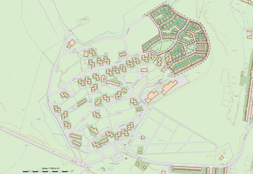
Contents                                           8 Movement                                      22   11 Community Safety              43
    1 Introduction                            1            8.1 Vehicular & Pedestrian Movement                 11.1 Shared Surfaces

                                                           8.2 Cycling                                         11.2 Natural Surveillance
    2 Context                                 2
                                                           8.3 Accessibility                                   11.3 Privacy
        2.1 Location
                                                           8.4 Public Transport                                11.4 Community Perceptions
        2.2 Site History
                                                           8.5 Road Network                                    11.5 Public & Private Realm
        2.3 Demographics
                                                           8.6 Parking                                      12 Access                        46
        2.4 Planning
                                                       9   Character                                   29      12.1 Topography
    3 Site Analysis                           11
                                                           9.1 Urban Grain                                     12.2 Access to School
        3.1 Land Ownership
                                                           9.2 Layout & Aspect                                 12.3 Servicing
        3.2 Land Use
                                                           9.3 Scale & Massing                                 12.4 Footpaths
        3.3 Topography
                                                           9.4 Dwelling Dimensions                             12.5 Entrances
        3.4 Existing Structures
                                                           9.5 Street Dimensions                            13 Phasing                       47
        3.5 Utilities
                                                           9.6 Appearance & Materials
        3.6 Ground conditions                                                                               14 Planning Contributions        48
                                                       10 Environmental Sustainability                 36
        3.7 Environmental Characteristics                                                                   15 References                    49
                                                           10.1 Vision
        3.8 Background Analysis Conclusions
                                                                                                            16 Appendices                    50
                                                           10.2 Environmental Goals
    4 A Vision for Penrhys                        18
                                                           10.3 Biodiversity
    5 Penrhys Regeneration Objectives 18                   10.4 Energy Efficiency & Carbon Reduction

    6 Phase 1 Development Objectives 19                    10.5 Micro-climate

                                                           10.6 Water Management
2   7 Land use                                19
                                                           10.7 Recycling

                                                           10.8 Environmental Resource Centre

    Design & Access Statement |
time to read the regeneration Master Plan that we have prepared. We hope and trust
    1 Introduction
                                                                                             that the Council Members will also do so, because this project shows a radically new
                                                                                             approach to the regeneration of the area. When completed it can be replicated but even
    The Regeneration of Penrhys was first raised as a possibility with the Founder of our    if its 'just a one off' it is hoped that it will be sensational, locally, regionally and even
    Company Ian Robinson in 2009, following an approach by the CEO of RCT Homes,             internationally.
    Andrew Lycett. Knowledge of the practical application of our unique model for
                                                                                             A paper written by a private and independent reporter for the Environmental Health
    regeneration (No Grants and no public funding) was gained from presentations made by
                                                                                             News in 2008 regarding the Tancred Road project can be seen alongside our photo
    Mr Robinson at the London School of Economics.
                                                                                             gallery on our web site www.independentregeneration.co.uk. In 2 pages it encapsulates
    A collaboration started between Independent Regeneration (Penrhys) Ltd. and RCT          the energy, enthusiasm and success of this model in similarly and 'allegedly' lost causes.
    Homes and a careful study made of what would be required to make Penrhys an              The Tancred Road Project won many awards and accolades including the North West,
    outstanding success. At the same time the residents of Penrhys have been consulted       Government Pathfinder Awards for Environmental Regeneration and Sustainability.
    and they agree that if the Master Plan that we have prepared with the residents is
                                                                                             Penrhys Partnership and the local Action Group originally did well to halt the large scale
    implemented it would be greatly welcomed.
                                                                                             depopulation of the estate. However, the remaining shops and services in Penrhys are in
    Skerries Road and Tancred Road Regeneration Projects, Liverpool were both acclaimed      danger of being lost if any further depopulation takes place. The introduction of new
    by the British Research Establishment (BRE) along with the Beeston, Leeds Exemplar       housing will reverse this trend and significantly increase demand for services and
    Project and the Westminster Briefing (generic regeneration briefing). CABE have also     provide new services for the existing residents. The introduction of new private housing
    referred to the Tancred Road and Skerries Road projects as regeneration case studies     will also help redress the imbalance of tenure in the village.
    (CABE, 2011). It should be noted that the confidence of all these organisations and
                                                                                             The Master Plan that we have prepared with our investment and know-how we believe
    others in our CEO and his model is based on the outstanding success of taking on
                                                                                             will change this forever, it will also provide jobs, a diverse commercial environment,
    projects that no one thought could be done and then completing them, in outstanding
                                                                                             training for local people and built in equity and opportunity, that it does not have now -
    fashion.
                                                                                             and never has. Penrhys will become the village "At the top of the Hill" for all the right
    The attraction to this project is the challenge. All of Independent Regeneration's       reasons. Indeed the Plan deals with each aspect that is required to make Penrhys the
    previous projects have had the same or even greater challenges.                          success it deserves to be. We therefore hope that the Council will accept our application
                                                                                             to make these massive inward investments in collaboration with RCT Homes and the
       "If Penrhys did not pose a challenge I would not do this scheme. Equally, if
                                                                                             Residents of Penrhys and start this regeneration process.
       Independent Regeneration do not invest heavily in regenerating Penrhys no one
       else will!"
                      Ian Robinson (10/12/2010) Speaking at a community consultation
                      event at LLanfair Uniting Church, Penrhys.

    Penrhys does have much potential, as a village, a community and a location. The views
1   are magnificent and the core majority of the community are committed to their village,
    to success in this project and to the welcome that they will give new enterprise,
    residents, diversity and sustainable investment. The Penrhys Residents have taken the

    Design & Access Statement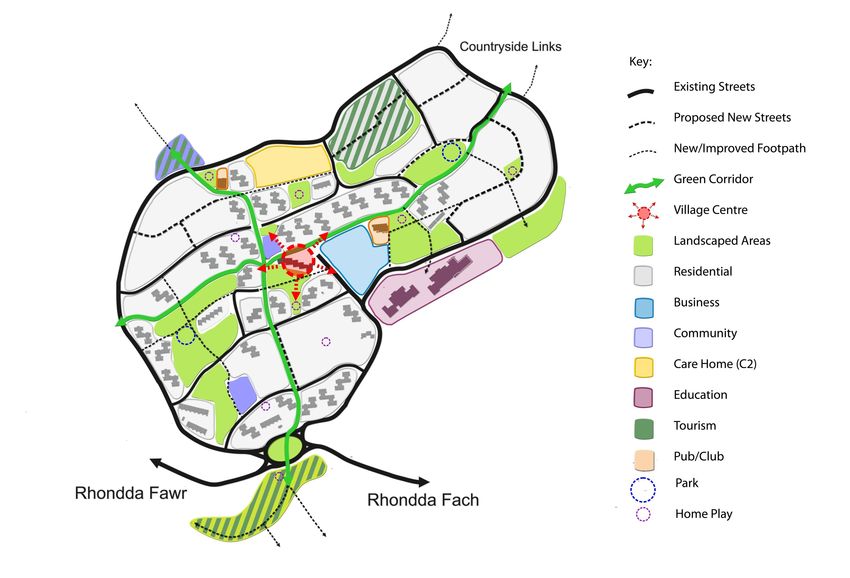
2 Context
    2.1 Location
    2.1.1 Penrhys is located within the Rhondda Cynon Taf Local Authority and is situated
          between two Valleys, the Rhondda Fach and the Rhondda Fawr. The village forms
          part of the Tylorstown Electoral Division. Penrhys’ central location in South Wales
          means that it is in close proximity to all the major urban conurbations in the south
          of Wales. Penrhys is approximately 25 miles from the Capital (45 minutes by train
          or car) and approximately 15 miles from the start of the Brecon Beacons National
          Park. Penrhys is also close to coastal resorts along the south coast.

    2.1.2 Penrhys is located on a very favourable south facing slope in an elevated position
          overlooking the valleys. At the base of Penrhys, St. Mary's shrine stands at 288m
          (944ft) above sea level and the top road is approximately 350m (1148ft) above
          sea level. Penrhys is located at the edge of the ‘Heads of the Valleys (HoV) Low
          Carbon Zone’, which is the largest of its kind in Europe and spans across a number
          of local authority borders and presents an opportunity to benefit from this.

    2.1.3 The Phase 1 development site is located at the eastern edge of the remaining
          village of Penrhys. It is located inside the perimeter road which forms the
          boundary for the development.

                                            Figure 1: Strategic location Map showing
                                            Penrhys’ proximity to major urban settlements,
                                            major transport corridors, the Brecon Beacons
                                            National Park and the Heads of the Valleys (HoV)
                                            Low carbon Zone.

                                            Figure 2: map showing Penrhys and Phase 1
2
                                            development site in red.

    Design & Access Statement |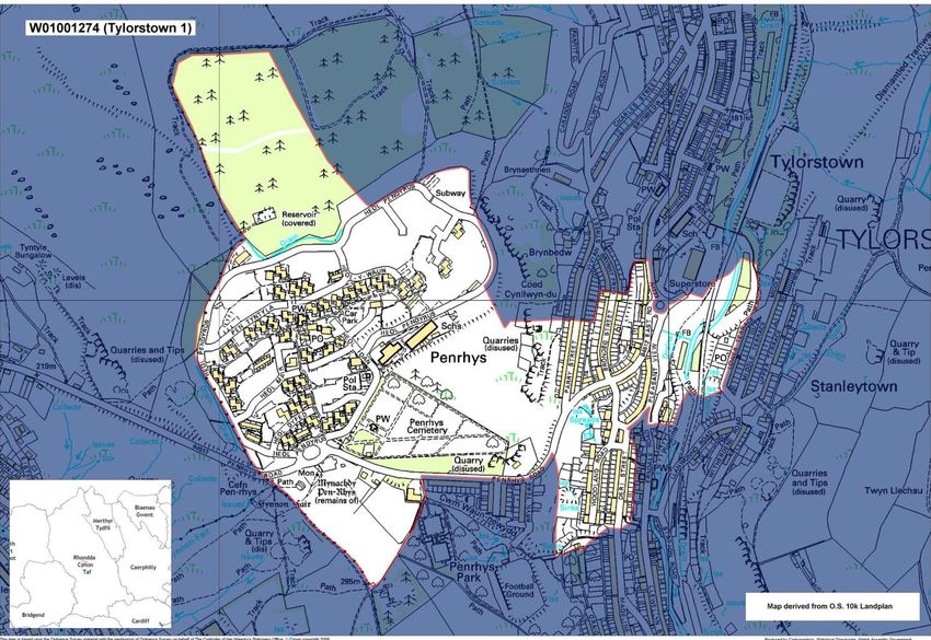
3   Figure 3: Panoramic view south of the far reaching view over the valleys from the top of the Phase 1 site. The unobstructed vantage point allows for open views for over 180 degrees.

    Figure 4: Panoramic view south from the north west of the village showing where Penrhys sits between the two Valleys. This is allocated as a future development site. Photographs
    taken by author.

    Design & Access Statement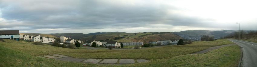
2.2 Site History                                                                                    became a single tenure neighbourhood with extremely high levels of
                                                                                                        unemployment.
         Before Development
    2.2.1 The name Penrhys is thought to have derived from the legend that the Welsh King
          Rhys-Ap-Tewdwr was beheaded by the Normans at this site thus giving the
          original village name Pen-Rhys ap Tewdwr (the head of Rhys ap Tewdwr).

    2.2.2 Penrhys is considered one of the holiest sites for Christian pilgrims in Wales. The
          site of Penrhys has a rich religious history dating back to mediaeval times due to a
          mediaeval monastery and the holy shrine of "Our Lady" built at the holy natural
          spring of Ffynnon Fair which still survives. The Shrine was the focus of intense
          piety and prayer prior to its destruction at the command of Henry VIII in 1538
          during the dissolution of the monasteries. In 1953, a new statue was built at the
          original site and since 1945 an annual pilgrimage from Llantarnam to Penrhys as
          taken place as part of the Cistercian Way. Prior to the development of Penrhys
          Estate, a farm was located at the crossing point of the two Valleys which is now
          the location of the roundabout and entrance to Penrhys. Penrhys undoubtedly
          has a rich cultural and religious heritage and the regeneration proposals will aim
          to maximise its tourism potential.

         Penrhys Estate Origins
    2.2.3 Penrhys Village, developed in 1966, was officially opened in 1968 and provided
          the largest public sector housing development in Wales with 951 dwellings. The          Figure 5: Coal-fired Boilers working at the original district heating system. Penrhys
          far reaching views and the clean air out of the valley floor were highly sought         Partnership.
          after. When first built Penrhys could have been considered to be a leader in
          sustainable energy provision due to its innovative district heating system. A
                                                                                                  2.2.4 The 1970's and 80's saw a spiral of decline and many problems that have become
          central coal-fired boiler and complete network of insulated pipes served each
                                                                                                        synonymous with 1960's social housing estates. These problems led to negative
          house with heating and hot water and was included in the price of rent. The
                                                                                                        media and gave Penrhys a stigma that it struggles to distance itself from today.
          failure of this system has been attributed to the increased cost of coal in the early
          1970's which meant that costs had to absorbed into the rent. This is thought to         2.2.5 In the late 1980's, the Priority Estates Programme saw the physical refurbishment
          have caused an outward migration of the working population and led to a process               of the entire housing stock along with environmental improvements in an attempt
4         of 'social engineering' whereby those on unemployment or other state benefits                 to rejuvenate the village but was unsuccessful as a result of low take-up of
          were relocated into Penrhys to fill the voids left behind. As a result, Penrhys               residents due to the reputation of the area. Newly refurbished houses were
                                                                                                        vandalised as they stood empty and led to the demolition of a number of blocks.

    Design & Access Statement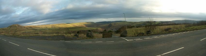
Through the 1990's, further demolition of properties and the lack of a strategic               longer creates a sense of arrival, as identified in the Hyder Open Space Audit
          approach saw the estate diminish in size and left large swathes of purposeless                 (2011).
          land within Penrhys which has interrupted the urban grain. Even further
                                                                                                   2.2.9 Penrhys remains an area that is viewed negatively despite the large majority of
          demolition was planned without any consultation with tenants living in the
                                                                                                         existing and previous residents have expressed their satisfaction with the quality
          properties identified and this led to the formation of a resident Action Group and
                                                                                                         of life in the village. Unemployment however is still very high and there is a
          the Community marching to the Council offices in 1997 to halt the demolition
                                                                                                         problem of worklessness and a need to bring jobs into the community.
          programme.

         Recent History
    2.2.6 The process of community regeneration began with the work of John and Norah
          Morgans and the development of Llanfair Church in February 1992. This saw the
          first Church opened in Penrhys for the first time in 800 years. Shortly after this, in
          1993, a new Penrhys Village Centre was created with the establishment of the
          Penrhys Partnership. In 1996 saw the development and opening of Cartref, a
          sheltered accommodation scheme for six families who enjoy their independence
          within the community. That same year the Canolfan Rhys Arts and Education
          Centre opened .

    2.2.7 The name Penrhys Village was adopted in 2003 as opposed to Penrhys Estate in a
          bid to reinvent itself following major demolition and the resultant fall in crime.
          Penrhys has become a much smaller, quieter community where many of the                   Figure 6: Penrhys Pilgrims annual event at the holy shrine 'Our Lady Of Penrhys'. Penrhys
          residents know one and other. The ability to remain close to extended family and         Partnership
          the community solidarity are amongst the positives that the village prides itself
                                                                                                   2.3 Demographics
          on. This is shown in the findings of the Hyder Open Space report (RCT Homes,
          2011). However, the fall in the number of residents in Penrhys has meant that                 Population
          public services and private businesses have become less viable such as a
          pharmacy, doctors surgery, the local community/shopping centre and even the              2.3.1 At present the total population of Penrhys is estimated at 792. Of RCT Homes' 287
          outdoor market.                                                                                residential properties in Penrhys, just 5 of RCT Homes’ dwellings are empty along
                                                                                                         with 10 long term voids that have fallen into a state of disrepair. A number of the
    2.2.8 When first built the community centre contained a large Spar, newsagents, hair                 Penrhys Partnership residential properties are also empty due to maintenance
          salon, bookmakers, boxing gym, gymnasium, café, bar, chip shop and a large                     issues. This will need to be addressed as part of the overall regeneration
          performance hall. However, over time each of these services was lost and in 2006               proposals. Penrhys has historically fallen victim to high tenancy turnover rates
5         the large community centre at the heart of Penrhys was demolished due to                       however, there are a core group of residents and families that have stood the test
          significant running and maintenance cost that hampered the Council. This has left              of time. Nonetheless, if no positive housing regeneration intervention takes place
          a large lifeless, purposeless area of land at the local centre of Penrhys and no               the population is likely to further decline and result in yet further demolition.

    Design & Access Statement |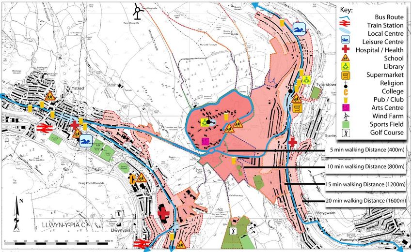
Residents chosen course of action is for inward investment to ensure the
          sustainable long term future of the village.
                                                                                                                                                                 0-15
    2.3.2 The age profile is noticeably young and the average age is much younger than the                          95
          norm within other valley communities. The mean age of the village is just 35.                           (12%)           214                            16-44
                                                                                                               182               (27%)
         Tenure                                                                                                                                                  45-64
                                                                                                              (23%)
    2.3.3 Looking back Penrhys really has not had a fair chance of success. The original
          concept was flawed in a number of ways. Single ‘tenure’ was perhaps the most                                      301                                  65+
          damning social factor, combined with local economic factors, low employment                                      (38%)
          prospects and a ‘Radburn’ layout for the Estate which has largely failed in most
          estates it has been used in throughout the UK.

    2.3.4 Originally there would have been 100% social rented housing in Penrhys.
          Although a number of residents have now purchased their home through the              Figure 7: Chart showing age composition of Penrhys.
          'Right to Buy' scheme the proportion of owner occupied houses is still very low. Of
          the 315 residential properties in Penrhys 287 are owned by RCT Homes, the
          Penrhys Partnership own and manage 16 residential units which are for rent and
          the remaining 12 are privately owned which is just 4% of the total housing stock.                               4%
                                                                                                                 5%                                       RCT Homes
    2.3.5 The remaining community is very settled, but there is no housing progression or
          other options for those that wish to stay/progress/improve their potential in their
          community or adjust their housing needs.
                                                                                                                                                          Penrhys Partnership

                                                                                                                                                          Private

                                                                                                                             91 %

                                                                                                Figure 8: Chart showing the proportion of private & social housing in Penrhys.
6

    Design & Access Statement |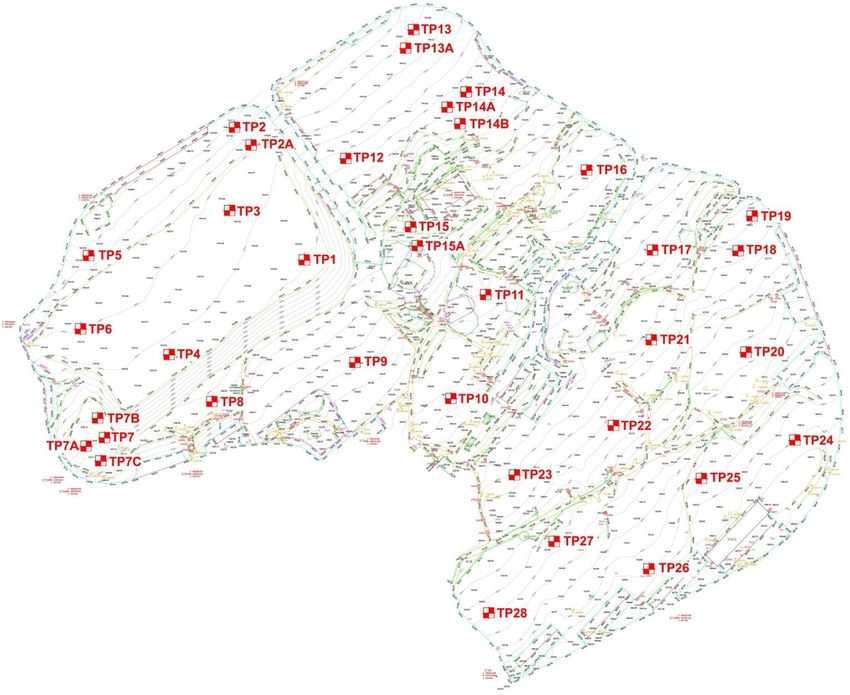
2.3.6 Housing management data indicates that there are issues with high levels of          Table 1: The Welsh Index of Multiple Deprivation
          refused tenancies and the number of vacant properties, which may relate to the
          poor reputation of the estate within the wider locality and the need for action to
          improve this reputation. Improvement of the housing stock and environment and                                                            Wales          RCT CBC
          the introduction of a major private housing programme, within a regeneration                                                            Ranking          Ranking
          initiative, would achieve this.
                                                                                                 Employment                                            5               1

                                                                                                 Education, Skills and Training                       38               5
         Welsh Index of multiple Deprivation
                                                                                                 Health                                               71               5
    2.3.7 The Welsh Index of Multiple Deprivation (WIMD) is the official measure of
          deprivation in small areas in Wales. This data underlines the importance of these
          regeneration proposals. For years unemployment levels in Penrhys have been
          very high and multiple generations of workless families has given rise to a
          'worklessness' mentality. Penrhys is ranked 5th most economically deprived in
          Wales, 1st in Rhondda Cynon Taf (RCT) with regards to employment. In order to
          increase job take up rates in Penrhys Independent Regeneration intend to actively
          seek to create employment opportunities within the village.

    2.3.8 Life chances are measured in relation to levels of Education, Skills and Training
          including Key Stages 2, 3 & 4, absence rates at Primary and Secondary Schools,
          proportion of people entering Higher Education aged 18 -19 and proportion of
          adults aged 25-29/64 with no qualifications. Penrhys is ranked 38th most deprived
          in Wales, 5th in Rhondda Cynon Taf (RCT) with regards to Education, Skills and
          Training.

    2.3.9 There is a direct correlation between the indicators of deprivation described
          above and the standard of health. In Terms of poor health Penrhys is ranked 71st
          most deprived in Wales, 5th in Rhondda Cynon Taf (RCT).

                                                                                               Figure 9: Area map of Tylorstown 1 Lower Super Output Area (LSOA) which Penrhys falls
7
                                                                                               within. Welsh Government (2011).

    Design & Access Statement |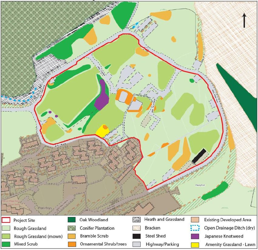
2.4 Planning                                                                               2.4.5 Penrhys is located in the Northern Strategy Area and is within the Settlement
                                                                                                     boundary, indicating that it is regarded as a sustainable location for new housing
         Local Development Plan                                                                      by Rhondda Cynon Taf County Borough Council (ibid.).

    2.4.1 The regeneration of Penrhys directly supports 7 of the 9 Core policies for
          Development in the Northern Strategy Area outlined in the Local Development          Table 2: Core Policy CS 1: Development in the North, RCT LDP
          Plan. Regeneration in Penrhys will have significant benefits to the Northern
                                                                                                 Promoting residential and commercial development in locations which will support
          Strategy Area. Policy AW 1 has identified that between 14,936-15,386 new               and reinforce the roles of Principal Towns and Key Settlements;
          dwellings are required in Rhondda Cynon Taf during the period up to 2021.              Providing high quality, affordable accommodation that promotes diversity in the
          Penrhys was not considered as a strategic development site within the Local            residential market;
          Development plan (LDP) despite offering large areas of Brownfield land within          Ensuring the removal and remediation of dereliction by promoting the re-use of
          the Northern Strategy Area. This represents a significant opportunity to deliver       under used and previously developed land and buildings;
          new housing where it was not anticipated in order to meet the Local Authority's        Encouraging a strong, diverse economy which supports traditional employment and
          housing needs over the next 20 years.                                                  promotes new forms of employment in the leisure and tourism sectors;
                                                                                                 Protecting the cultural identity of the Strategy Area by protecting historic built
    2.4.2 Of all the 20 newly built residential estates within RCT over the last seven years     heritage and the natural environment,
          none are located further north than Tonypandy in the Rhondda Fawr and there            Promoting and enhancing transport infrastructure services to support growth and
          were no large scale developments at all in the Rhondda Fach (Rhondda Cynon Taf         investment, and
          County Borough Council Newly Built Homes Survey, 2011).                                Reducing daily out commuting by private car and promoting sustainable forms of
                                                                                                 travel.
    2.4.3 Perhaps the most direct statement relating to this regeneration project is
          paragraph 4.28; this state that:
                                                                                               Table 3: Policy AW 2 - Sustainable Locations
           "The LDP will provide a policy framework that seeks to secure regeneration
                                                                                                Are within the defined settlement boundary or in the Northern Strategy Area, accord
           and create sustainable communities in the Northern Strategy Area. Through            with Policy NSA 12;
           the provision of new housing, employment opportunities, improvements in
           accessibility and the implementation of large-scale regeneration proposals the       Would not unacceptably conflict with surrounding uses;
           Council will seek to halt depopulation and the process of decline."
           (RCT CBC, 2011a, pp. 30)                                                             Have good accessibility by a range of sustainable transport options;

    2.4.4 During early pre–application discussions with RCT CBC planning officers it was        Have good access to key services and facilities;
          agreed that the density for Phase 1 could be lowered to 20 dwellings per hectare,
          if required, due to the nature of the development and its location. The scheme        Do not permit highly vulnerable development and Emergency Services within Zone C2
          will aim to achieve a compact layout while at the same time ensuring there is         floodplain. Within Zone C development will be permitted where it can be justified that:
8                                                                                                  a) It is necessary to assist the regeneration of a Principal Town or Key Settlement
          adequate space for public and private amenities.
                                                                                                      including the key employment objectives, or where development involves a large
                                                                                                      Brownfield site.

    Design & Access Statement
b) the potential consequences of a flooding event have been considered and found application is for the residential development of land at Hendrefadog, Tylorstown
to be acceptable in accordance with national guidance and meet the definition of and measures approximately 5.7 hectares. The site is located in an elevated
previously developed land. position on the hillside above Tylorstown. The majority of the site was formerly a
local authority housing estate comprising approximately 90 residential properties
Support the roles and functions of the Principal Towns, Key Settlements and Small
until their demolition in March 1998. An informal footpath connecting Penrhys to
Settlements There are no constraints identified in Penrhys in the Adopted Local
Development Plan 2011 Constraints Map. Hendrefadog and Tylorstown shows that there is a desire-line and willingness for
Are well related to existing water, sewerage, waste, electrical, gas and residents to use this route to travel between neighbourhoods. The regular use of
telecommunications infrastructure and improvements to such services will be this track has been confirmed through public consultation. A similar pathway
provided where necessary. connects Penrhys to Llwynypia and Tonypandy. It is essential that these routes
are maintained and improved as part of any development proposals.
National Planning Policy
2.4.6 As well as complying with RCT CBC's Design & Placemaking SPG (2011) this
application has taken into account national policy. In order to deliver a
benchmark scheme in terms of sustainability and wellbeing Independent
Regeneration and its partners will closely follow guidance set out in TAN 8, 12,
13, 16, 21 & 22. The development in Penrhys will also be designed using design
guidance set out within Manual for Streets and will draw precedence from a
number of good examples of urban design, sustainability and delivery.
Related Planning Issues
2.4.7 In order to understand the context in which Penrhys is located it is necessary to
look at any other relevant planning proposals within the area. The LDP has
identified two housing allocations near Penrhys; these are NSA 9.13, Land at
Gwernllwyn Terrace, Tylorstown and NSA 9.19, hospital site, Llwynypia. Both sites
are within 1 mile of Penrhys and are located along walking desire lines between
Penrhys to Tylorstown and Penrhys to llwynypia. The Tylorstown site is 1.11
hectare linear area of Brownfield land on the edge of the village of Tylorstown.
The former hospital site in Llwynypia is the largest of all the non-strategic sites
with an anticipated 190 dwellings (RCT, 2010a, LDP) on the 6.39 ha site.
2.4.8 Outline planning permission has also been granted for the redevelopment of the Figure 12: Map showing Penrhys in relation to LDP local Housing Allocations and
9
site formally known as Hendrefadog (Application Number: 05/1769/13). The planning consents. The map also shows the existing connections to surrounding
neighbourhoods that need to be protected.
Design & Access Statement |1
0
Figure 13: LDP Map showing Penrhys within the Settlement boundary and the surrounding Sites of Important Nature Conservation (SINC). The inset shows Penrhys’ central location within the RCT
local authority area.
Design & Access Statementis Brownfield land and includes the remains of hard surfaced roads, car parking
3 Site Analysis and steps still remain on site. Additionally, a large proportion of the land in
Penrhys is space left over as afterthought by the original housing layout.
3.1 Land Ownership
3.2.4 Given the relatively high proportion of younger residents, there is very little play
3.1.1 When the Council's housing stock in the Rhondda Cynon Taff was transferred to space and gathering space provision. The only remaining park towards the
RCT Homes the Council housing in Penrhys was transferred with the rest of the western edge of the site had the large majority of its play apparatus removed
properties. This also included all the associated open space within the perimeter despite being very well used by local children. A small caged enclosure located on
road that forms the boundary around Penrhys. RCT CBC retained responsibility the site of former flats is used as a sports area by children. Another hard surfaced
for the roads, footpaths and lighting within Penrhys. The Forestry Commission caged area is located by the Arts Centre but is very rarely used. A new landscape
owns the land immediately to the north of the estate. strategy will need to be developed to ensure that new proposals meet the
3.1.2 At present there are some 326 properties in Penrhys, for all uses, of which 288 demands of the community.
are owned by RCT Homes. There are 12 units owner occupied including the Public
house and the former police station. The primary school, the Flying Start Centre,
the Boiler House and the former Buffalo Club are not within RCT Homes'
ownership. The remaining properties fall within the Penrhys Partnership's
ownership. Penrhys Partnership own and manage 3 community buildings, which
houses the Post Office and Shop, Fast Food shop, Training Centre and offices.
3.2 Land Use
3.2.1 There are a wide variety of uses in Penrhys that adequately serve the community.
The majority are located centrally including the local church, shop, post office,
cafe and fast food outlet (See Figure 14). The local infant and primary school is
located just south east of the centre along with a new Flying Start education
centre.
3.2.2 At present there are also a number of vacant residential and commercial
properties available within the Y Ffynon Centre buildings and this will be
addressed as part of the regeneration programme.
Figure 14: A 3D model showing mixed-use within Y Ffynnon Centre at the heart of
3.2.3 The large majority of land undeveloped in Penrhys is Brownfield land where Penrhys.
houses, flats and other community uses once stood. This land has been left to
11
stand with limited landscaping work and in some locations no effort has been
made at all; this is the case with the Phase 1 development site. 100% of the land
Design & Access StatementFigure 15: Land Ownership Map
1
2
Design & Access StatementFigure 16: Land Use map
1
3
Design & Access Statement3.3 Topography
3.3.1 The topographical survey completed by Alpine Land Surveyors provides a very A
detailed picture of not only the topography of the land; it also includes the
location of existing built structures such as walls steps and footpaths and the
technology used also has the ability locate underground utilities (See Appendix 1).
The survey provides contour lines at 1m intervals as opposed to 10m intervals so
that the terrain is accurately represented. This information will allow us to
determine layout and spacing standards so that the maximum number of units
will have south facing views over the valleys and the surrounding environment.
3.3.2 The most uniform sloping areas of land are located across the south of the site
and at the north east corner of the site. Across the centre of the site the land has
been stepped using a number of retaining walls, thus creating areas where the
slope is quite steep and other flatter areas; these were once the location of the
nursery and car parks.
3.3.3 The made up land in the north west of the site is where most of the rubble from
the demolition of the remaining houses was disposed. This has created a large
area of flat land which has the potential to locate larger communal or commercial
buildings. It also has a favourable vantage point over the valleys.
B
A B
14
Figures 17 18 & 19: Contour diagram of Phase 1 development site with section & 3D
model.
Design & Access Statement3.4 Existing Structures
3.4.1 The only remaining building left on the Phase 1 site is a former youth club made
of corrugated metal, this is located on the southern perimeter road. The last use
for the building was for council storage but is now empty and abandoned. The site
survey identified all of the existing roads, hard-standing areas and remaining
footpaths, steps and lamp-posts that were not removed as part of the demolition
works.
3.5 Utilities
3.5.1 In order to reduce costs and retain some of the sites original identity the new Figure 20: Left-over structures in the development site. Photographs taken by author.
development should aim to utilise as much of the existing infrastructure as
possible.
3.5.2 The original aspiration was to utilise the original drainage system that has been
described as a 'work of art' by a drainage engineer, for waste water, however, due
to the former demolition work and compacting the state of the drainage system is
not fully understood. A detailed drainage survey will need to be undertaken in
order to identify the potential of using the existing system. Where this is not
possible a new drainage system will be provided along with a new surface water
management system.
3.6 Ground conditions
3.6.1 As part of the land survey ground conditions were also examined due to the
unknown state of the land following demolition. Terra Firma produced a
Geotechnical & Geoenvironmental report whereby they piled 28 trial pits across
the site, including the flattened made up ground in the north west (Terra Firma,
2011). Samples were also taken to a laboratory for testing. The report found that
the made ground varied in depth and quality throughout the site and
subsequently provided a number of construction piling solutions and was used to
influence the phasing of Phase 1.
15
Figure 21: Land Survey showing contours, existing structures and Trial Pit locations.
Design & Access Statement |3.7 Environmental Characteristics - Important Flora /Fauna
3.7.1 An Ecology Survey of the Phase 1 development site application was undertaken by
Environgauge as part of the planning application requirements and is attached.
Based upon the evidence which has been gathered through this study,
redevelopment of the site will not result in the loss of any habitats of high
ecological value or nature conservation interest. Any site constraints that have
been identified are accompanied by measures to address the issues (See Ecology
Report) .
3.7.2 Immediately to the East of the site is a designated Sites of Important Nature
Conservation (SINC).
Figure 22: Habitat Map of the site and its surrounding context. The map shows that the
majority of the site is now rough grassland with a number of areas of ornamental shrubs
pepper-potted within the site from the previous development.
16
Design & Access Statement |3.8 Background Analysis Conclusions and future residents of Penrhys have the best possible chance of living and
sustaining a happy and healthy future.
3.8.1 For Penrhys, long-term financial stability and redressing the social imbalance are
the two key issues at the forefront of the regeneration process. Here, economic 3.8.3 The regeneration of Penrhys also presents a significant opportunity to deliver new
and social sustainability it could be argued are more important than housing in the Northern Strategy Area and support the principal towns of
environmental sustainability. If significant inward investment is not secured then Ferndale and Tonypandy while at the same time helping the Local Authority meet
Penrhys would continue to decline. Piecemeal investment is simply unsustainable. its housing targets.
"...in certain cases not all circumstances will be ideal and that decisions over
priorities will need to be made on the basis of evidence of need and an
assessment of all material considerations."
RCT CBC (2011a) Local development Plan. Policy 4.29
3.8.2 Despite the fact that economic and social sustainability are foremost important,
Independent Regeneration will go to considerable lengths to ensure that the new
development is highly sustainable and exceeds the energy efficiency standards set
within Wales and will also improve the environmental performance of the existing
housing stock. However, due to the fact that this is a community regeneration
project and not a ‘clean slate’ new build, a number of parameters have already
been established. Certain aspects of design which are usually central to creating
sustainable neighbourhoods need to be stepped down the priority ladder to
ensure that other more pressing issues can be dealt with. In an ideal scenario, a
new sustainable neighbourhood would be designed as a transit-orientated-
development (TOD) located along major transport corridors, with densities of 50
dph+ etc. The decision to create a village, with great intentions, on the
mountainside was made some 50 years ago and cannot be reversed. Whether the
location was right or wrong, it is now in all our interests to ensure that the current
17
Design & Access Statement4 A Vision for Penrhys
The Master Plan has from the beginning of the Penrhys Project, developed a wide and comprehensive approach to complete a highly sustainable regeneration project. The
Strategic Vision for Penrhys needs to be flexible enough to allow for changes so that if and when later studies and detailed plans are undertaken they build upon the general
structure set out in the vision. The regeneration will target social, economic and environmental sustainability and seek to be an exemplar for regenerating failing social housing
estates.
5 Penrhys Regeneration Objectives
In order to achieve the Vision for Penrhys, Independent Regeneration (Penrhys) Limited has identified a number of key regeneration objectives, these are:
to increase the population of the village in order to support existing services and to reinstate lost services;
to facilitate housing progression within Penrhys by providing a spectrum of tenure and type throughout all phases. This will enable residents of Penrhys to climb the social
housing ladder as well as provide a ‘safety net’ in the unfortunate event that people find themselves in difficult circumstances;
to rebalance the age mix within the community, particularly attracting those with equity and dovetail an over 50's supported housing scheme via owner occupation;
reduce the level of unemployment by attracting more people with jobs and introducing new jobs;
to introduce new commercial ventures, fostering social enterprise and significantly increase the number of training opportunities;
to promote environmental sustainability through innovative new buildings and resource management and put Penrhys back at the forefront of sustainability;
to develop Penrhys as a hub for environmental tourism and education by developing an environmental information centre;
to create safe walking routes within the village and improve links to neighbouring communities;
to provide high quality landscaping with green corridors, new parks and public spaces;
to reconnect Penrhys with its cultural heritage by improving links to the religious shrine; and
18
to consult and engage residents throughout each stage of the regeneration programme;
Design & Access StatementFigure 23: Penrhys Spatial Vision Diagram
1
9
Design & Access StatementFigure 24: Penrhys Phase 1 Development Framework
2
0
Design & Access Statement6 Phase 1 Development Objectives:
7 Land use
The objectives for Phase 1 of the regeneration process have been devised following
the urban design appraisal and tissue analysis of the existing development within 7.1.1 At present it is difficult to determine exactly what inward investment
Penrhys along with a thorough site assessment and the priorities established by opportunities will arise in later phases. Independent Regeneration understand
Independent Regeneration. The following objectives were used as a development that this may be lengthy process and that flexibility must be built in to the plan.
brief and points of reference when designing an initial layout for the scheme (see Redressing the imbalance of tenure has however been identified as a priority,
Figure 24). therefore Phase 1 will provide 100% private housing.
7.1.2 RCT CBC have expressed the need for new care home provision within the local
Maximise use of existing utilities and infrastructure. authority and have been working with Independent Regeneration, RCT Homes
and the Local Health Board to establish potential demand. Independent
Maximise number of south facing units. Regeneration have also had advanced talks with care home providers who are
keen to deliver a scheme in a later phase as part of the wider regeneration
Reduce the amount of surface run-off water by introducing a variety of water programme in Penrhys. With 95 residents ‘over 65s’, a care home is a possible
management techniques option, as part of an overall development and could provide another opportunity
for residents to continue their village life around their families. The right size of
Ensure each unit has sufficient natural day-lighting in the home and private facility could also provide a service for a much wider catchment area and in doing
garden to improve quality of life and reduce the need for artificial lighting. so provide a wide range of jobs within the village.
Design infrastructure with minimal cost so that developers incur the cost of
the public private interface.
Create blocks and spaces that are secured by design.
Provide view corridors through the public realm.
Provide spaces for garages and additional car parking (car pooling).
Provide attractive pedestrian corridors to the existing community from the
outset.
21
To create streets not access roads.
Design & Access Statement8 Movement
8.1 Vehicular & Pedestrian Movement
8.1.1 The private housing in phase 1 has been designed in a way that is intended to
purposely integrate and connect the old with the new. The Phase 1 site is in very
close proximity to the existing facilities in the Village centre and this in itself
should encourage walking for daily essentials. The proposed new Green Corridor
to the centre will also encourage walking to the village centre. Other streets have
also been designed to stitch the old and the new together (See Figure 29). The
Phase 1 scheme is perhaps best placed to provide safe and attractive routes to
school. Plans to improve existing routes to school are already being discussed and
will be brought forward as part of the wider regeneration programme.
8.1.2 A hierarchy of streets and open spaces will be used within Phase 1, each with a
different character, in order to provide an element of legibility. Of the junctions
with Heol Pendyrus it is anticipated that only four will be priority junctions, the
rest will be used to maximise pedestrian accessibility or to accommodate
emergency vehicles
8.1.3 By creating streets and not access roads, vehicles and pedestrians can come
together improving the vitality within the street and encouraging social
interaction - a vital part of creating successful communities.
8.2 Cycling
8.2.1 The east-west axis will encourage the use of bicycles to and from the Village
centre. Phase 1 is also in close proximity to existing forestry tracks which are well
used for recreational cycling.
8.2.2 Secure cycle storage will be provided in each new dwelling in Penrhys as part of
promoting alternative modes of transport to the car and to encourage healthier
lifestyles.
22
Design & Access Statement |8.3 Accessibility Table 4: Accessibility / Walkability
8.3.1 Accessibility to local shops and services has been calculated by using ped-sheds.
Distance / Time Service
Ped-sheds look at ‘walkability’ and allow for a more accurate understanding of
actual walking distances and time (Llewelyn Davies, 2000). Measuring accessibility
5 minutes (400m) Penrhys Village Local Centre (Local Shop, Post office, Take-away food,
using concentric rings for catchment areas is useful for giving a general
Church, Library, cafe, Launderette, Boutique)
understanding of accessibility, however, the fact that Penrhys Village is located
Community Organisation (training and events, internet access)
within the Valleys means that the distribution of settlements has primarily taken Infants and Primary School
the form of ribbon development. This means that the use of concentric rings Flying Start Centre
would not give a truly accurate representation of actual walking distances. A Arts Centre
distance of 400m is used to roughly translate to 5 minutes walking time in order Cemetery
to include all members of society (Barton et.al. 2010) and was used to map all of Public House
the shops and services within 5, 10, 15 & 20 minutes. The accessibility findings are Half Hourly Bus Service
Hourly Train Connection
supported by the findings of the Transport Study.
Religious Shrine (St Mary’s Statue *our Lady of Penrhys+ St Mary’s Well)
8.3.2 Catchment viability tables such as the one provided in ‘Shaping Neighbourhoods’ Amphitheatre
(Barton et al. 2010) provide a very useful guide for developing new 10 Minutes Lawn Bowls
(800m) Tennis Courts
neighbourhoods. The South Wales Valleys are unique due to the formation of
Tylorstown Rugby Club
ribbon development along the valley floor and if standard catchment statistics
Forestry Tracks
were used, most of the existing, shops, doctors’ surgeries, dentists, pubs and post Half Hourly Bus Service
offices would be deemed unviable. These services are nevertheless still required 15 minutes (1200m) Rugby Field
even though catchment populations will be reduced. Paddling Pool
Rhondda Golf Club
8.3.3 In order to test the perceptions that Penrhys is inaccessible and remote in adverse
weather conditions Independent Regeneration has sought information from RCT
20 minutes (1600m) Local General Hospital
Homes. As landlord of the large majority of existing properties RCT Homes are Doctors Surgery (with Pharmacy)
perhaps best placed of any organisation to make a statement about accessibility. Supermarket
RCT Homes found that they experience no greater difficulty in accessing and 2 Primary Schools
servicing the Penrhys estate as any other community within the Borough when Library
experiencing heavy winter snow and ice conditions. Penrhys benefits during cold Leisure Centre
periods as it has a school and bus routes which means that main access and egress Football Pitch
5 Public Houses
roads are routinely gritted and cleared. RCT Homes stated that they have
Care Home
experienced access difficulties on less than 10 days in the last 3 years. The
23 Regular Bus Service
majority of time they are able to get up to Penrhys. The findings are also mirrored
Llwynypia Train Station (Half Hourly Service)
by Homeforce. Tylorstown Local Centre (Local shops, Post Office, Take-away food,
Hairdressers)
Design & Access Statement |2
4
Figure 26: Accessibility Map showing local shops and services within walking distance of Penrhys.
Design & Access StatementFigure 27: Images of local services. Photographs taken by
author.
Top: Y Ffynon Centre (Penrhys Village Centre); Forestry
tracks; Public transport.
Middle: Local General Hospital; Canolfan Rhys Arts &
Education Centre; Tylorstown Leisure Centre.
25
Bottom: Penrhys Golf Course; Llanfair Uniting Church.
Design & Access StatementTable 5: List of Bus Services
8.4 Public Transport
Service Operator Origin Via Destination Frequency
8.4.1 The Treherbert to Cardiff rail line runs along the valley floor providing a half
(Mon - Fri)
hourly service up and down the Rhonddda Fawr. A Rail-Link bus service provides
155 Stagecoach Porth Ynysir, Ferndale 3 journeys
an hourly connection between Maerdy to Ystrad Rhondda train station via
Stanleytown, daily
Penrhys and vise-versa.
Pontygwaith,
8.4.2 Penrhys is connected to half hourly bus services via the number 171 and the 172 Tylorstown,
services which connect Penrhys to the Valley floor. The existing 171 bus service Penrhys roundabout
already completes a full circuit of the Heol Pendyrus perimeter road around 171 Stagecoach Maerdy Ferndale, Clydach Vale Every 30
Penrhys despite the far eastern side being demolished. Regular bus stop intervals Tylorstown, minutes.
are still in place but all of the bus stops in Penrhys will need to be restored. These Penrhys Estate, 07:26
to 17:47
will need to be attractive and clean in order to encourage the use of public Ystrad,
transport. Llwynypia
Tonypandy
8.4.3 The existing 171 bus service currently does a loop around Penrhys on the
172 Stagecoach Aberdare Ferndale, Porthcawl 06:07, 07:36,
perimeter road and the location of where bus stops once stood is still evident. 08:36, 08:51,
Penrhys roundabout,
Attractive new bus stops will be located in similar locations improving access for 09:36 then
Sarn Sainsbury's,
new residents and visitors for Phase 1 and later phases. One bus stop will be hourly until
Royal Glamorgan
located at the bottom of the site and the other will be located on the top road, 17:36, 18:43
Hospital,
just to the west of the development site. The bus stop on the top road will be
Bridgend
positioned here in order to provide accessibility to new residents and because it is
902 Thomas Ystrad Penrhys roundabout, Maerdy 07:49, then
located adjacent to the potential new housing and or tourism use identified in the every hour
Coaches Rhondda Tylorstown,
Penrhys Spatial Vision. Figure 28 Shows that the 2 new proposed bus stops until 17:49
Ferndale
comprehensively cover the Phase 1 development and future development phases
Rail Arriva Maerdy Ferndale, Ystrad Train Every hour.
as well improving the choice for existing residents. Originally, there was a bus
Link Trains Tylorstown, Station 07:00 to
stop in the village centre. The potential of locating a new bus stop in the village
Wales Penrhys roundabout 19:00
centre at a later stage will also be investigated in order to increase the number of
people visiting the centre as opposed to bypassing it on the perimeter road.
26
Design & Access Statement8.5 Road Network
8.5.1 Penrhys is served by Penrhys Road, B4512 which is a very important route for
those travelling between the two valleys. The recently completed Porth Relief
Road has significantly alleviated traffic problems in the Rhondda Fach and as a
result has reduced travel times between Penrhys and Porth Significantly. The LDP
has included plans to extend this road up the remainder of the Rhondda Fach
along the route of the former railway line.
8.6 Parking
8.6.1 The majority of dwellings are likely to have one or more parking space on plot
with a garage. On-street parking will also be used to accommodate resident and
visitor parking needs. The communal open spaces will also be utilised for parking.
Residents adjacent to the development raised concerns over the future of their
current well used parking facilities, particularly at the edge of the central open
space. A number of landscaping and car parking solutions will be drawn up and
the residents will continue to be consulted as more detailed plans are required.
Figure 28: Location of existing and proposed bus stops with 200 metre buffer zones.
27
Design & Access Statement |Figure 29: Relationship between the new and existing developments.
2
8
Design & Access Statement9 Character
9.1 Urban Grain
9.1.1 Due to the fact that the existing urban grain, street network and block structure
has failed, as found in the urban design appraisal and tissue analysis, future
phases, including Phase 1 will aim to provide an altogether new urban structure
based on proven urban design principles. However, the development will aim to
maintain some of the original characteristics of Penrhys. By re-using and re-
connecting to existing roads and footpaths where possible the east-west structure
will be maintained. Future infill development will also be used to re-define the
street and enhance the street-scene where possible by locating frontages on the
on the street.
29
Figure 30: The new development will form a new character area.
Design & Access Statement9.2 Layout & Aspect
9.2.1 As with most housing in Rhondda Cynon Taf urban development tends to follow
the topography; this is what gives the valleys its beautiful distinctive character.
Part of what makes the valleys scene so interesting is that houses are often
located in unusual places. The original layout of Penrhys generally follows the
shape of the land and this is evident when looking at the main east-west axis.
However, the original design failed to maximise the potential of its location on the
elevated south facing slope. Phase 1 will ensure that this potential is maximised
by using a similar terracing approach as used along the valley floor while at the
same time reducing block sizes in order to break up monotony and increase the
number of options for pedestrian movement.
Figure 31: Phase 1 Development site is
largely dictated by the topography of the
site. Also showing location of site section.
30
Figure 32: Site Section showing that the slope has been used to maintain south facing views over the valleys.
Design & Access Statement |9.3 Scale & Massing
9.3.1 The site area identified within the red line boundary is 4.2 hectares. With the 107
dwelling shown in the Development Framework this provides a density of 25.5
dwellings per hectare (dph) which is well within the guidelines outlined in pre-
application consultation discussions with the planning department. Penrhys is not
confined by the cramped space of the valley floor, therefore Phase 1 offers
favourable plot sizes with generous amounts of associated open space. based on
the UK average household size the 107 new homes has the potential to introduce
257 new residents into the village taking the total population to back up to over a
1,000 for the first time since the demolition programme.
9.3.2 The phase 1 development framework has been designed with flexibility in mind.
However, the initial framework has also taken into account building types and
scale in order to give an indication of a mix of private tenure options.
9.3.3 Building heights have also been considered in order to create legible streets and
open spaces. Building heights generally rise from the bottom of the site to the top
in order to ensure that even with linear streets dwellings can still have a south
facing view, thus giving a terracing effect. Building heights around the central
green space are also increased in order to define the large open space and
introduce some sense of hierarchy.
9.4 Dwelling Dimensions
Table 5: Dwelling Dimensions
Lower Limit Upper Limit
Length 7m 13m
Figure 33: Distribution
Width 4m 8m of house type and
variation of building
31
Height 6m 10m
heights to provide
legibility and street
hierarchy.
Design & Access Statement |9.5 Street Dimensions
9.5.1 Street widths will be reduced where possible to ensure that the street scene is
maintained with the slope of the land while at the same time ensuring that
overlooking south facing views of the valleys are achievable. Spacing also allows
for suitable daylighting for dwellings and private garden space.
Section Location
32
Figure 34: Typical Street Section showing dimensions. Scale 1:100
Design & Access Statement3
3
Figure 35: Typical street Plan showing change of materials & street furniture. Scale 1:100
Design & Access Statement9.6 Appearance & Materials
9.6.1 Independent Regeneration want to blur the boundary between the old and new
as much as possible despite introducing larger, modern properties. RCT Homes'
major new external re-cladding programme will significantly change the aesthetic
appearance of Penrhys and this work is taking place at a perfect time of the
regeneration process. The new cladding in Penrhys will consist of smooth
rendered pastel colours. New housing will be required to use a similar palette of
colours where possible.
9.6.2 Developers will be encouraged to use the most energy efficient materials
available to reduce the carbon footprint of the buildings. Dwelling designs will
need to be agreed by Independent Regeneration and satisfy Planning and building
regulation requirements.
9.6.3 It is anticipated that all south facing roofs will have solar panels attached which
will have an impact on the appearance of the development. As part of the
regeneration proposals plans are being drawn up for the existing RCT Homes
housing stock to be fitted with solar panels. Solar panels will be located on south
facing visible roof slopes. Penrhys is not located in a visually sensitive
conservation area and therefore this proposal is in line with the Council's
Supplementary Planning Guidance (2011c).
34
Figure 36: Impression of what Penrhys will look like when re-cladding is complete.
Design & Access StatementFigure 37: Images to show the types of materials that will be used in Penrhys.
Top Left: Example of new housing style to match render. Newhall, Harlow.
Top Right: Example of Bin Stores to be used in Phase 1.
Bottom Left: Discreet change of surface materials used to determine different
35 space users in shared surface street. Upton, Northampton.
Bottom Right: Typical image of solar panels to be used on roofs.
Design & Access Statement |10 Environmental Sustainability homes and the use of system based renewable technologies in order to minimise
environmental externalities. Independent regeneration will investigate the
10.1 Vision potential for using of a variety of water management solutions that will add to the
quality of the public realm. Independent Regeneration and its partners will use
10.1.1 Penrhys was seen to be at the forefront of energy efficiency in Wales when first the following headings to set tangible sustainable objectives that will need to be
built and the regeneration of Penrhys aims to be a leader in sustainable agreed in order to be used as a measurement of success.
regeneration by seeking to introduce environmental technology and sustainable Land Use:
resource management. Re-use and transformation of 'Brownfield' land into attractive residential areas
10.1.2 The development will accord with the sustainable energy strategy set out by the with high quality public realm.
Welsh Government and will form part of our sustainable development objectives Use existing road infrastructure
for the site. The strategy is based on the following hierarchy: Maximise the use of existing utilities wherever possible.
1. Minimise the demand for energy Energy:
2. Supply energy efficiently All houses will meet at least Code Level 4 of the Code for Sustainable Homes
3. Use renewable energy Maximise number of south facing units for solar energy gain and natural lighting.
Each unit will be required to include at least one form of renewable energy.
Potential wind power.
Water & Sewage:
Minimise the use of surface run-off
Maximise the use of existing drainage network
Potential for anaerobic digestion on site.
Potential for Hydro-electricity using water and the slope of the land.
Transport:
Reduce the need for people to travel by car
All houses are located within 5 minutes of the village centre and the school
Figure 38: TAN 22 clearly sets out Welsh Government’s priorities in terms of reducing Potential for car pooling
Carbon Emissions Maximise cycle parking
10.2 Environmental Goals Waste:
36 10.2.1 Making this project an exemplar in Low Carbon and Sustainable Energy is one of
10.2.2 Thoroughly sorted waste in a practical system to maximise recycling wherever
our fundamental objectives and we aim to deliver a number of benchmark
possible.
sustainability projects. Independent Regeneration will look to energy efficient
potential for Envac vacuum waste collection system or equivalent.
Design & Access Statement |10.3 Biodiversity
10.3.1 100% of the land identified in Phase 1 is Brownfield and is of low ecological value.
This will be transformed into a new residential area with associated parks and
landscaping. EnvironGauge have undertaken an ecological appraisal and Phase 1
Habitat survey that will accompany the Planning Application alongside the Design
& Access Statement. The report identifies any mitigation measures that will be
required prior to work starting on site.
10.3.2 The existing fenced communal garden area to the west of the site contains a
cluster of planted trees This garden will be retained and incorporated into the
new development and new semi-natural landscaped gardens will enhance
biodiversity within the Phase 1 site.
10.4 Energy Efficiency & Carbon Reduction
10.4.1 Independent Regeneration's aspirations are that all of the new Homes in Penrhys
will achieve at least Level 4 of the Code for Sustainable Homes. Code assessors
will be used in accordance with guidance to ensure that scores actually meet the
Figure 39: Historic map showing high density development on the development site.
requirements as stated for each criteria at both design stage and on completion.
Independent regeneration will also seek to deliver at least one Code Level 6 Home
and deliver a house that meets the Passive House or Passivhaus standard.
10.4.2 Independent Regeneration will, where possible, engage local housebuilders and
contractors and encourage them to be adventurous and test new technologies so
that they develop their understanding of providing energy efficient homes.
Independent regeneration will target those housebuilders looking to build pilot
schemes in order to expand their level of awareness and skill and experience in
providing high quality, energy efficient homes and neighbourhoods.
10.4.3 Restoring the 10 remaining long term voids in Penrhys for affordable housing as
part of the Section 106 Agreement will make the residential blocks as a whole
more efficient through reducing heat loss. By refurbishing existing stock and
strengthening the viability of the village as opposed to demolishing and replacing
37 with new build we will also reduce the carbon footprint significantly.
Design & Access Statement |You can also read