Development of an expanded earthquake and ground motion catalogue for New Zealand
←
→
Page content transcription
If your browser does not render page correctly, please read the page content below
Development of an expanded
earthquake and ground motion
catalogue for New Zealand
J.A. Hutchinson, R. Lee & B. Bradley
University of Canterbury, Christchurch

C. van Houtte & A. Kaiser
GNS Science, Lower Hutt.

L. Wotherspoon
The University of Auckland, Auckland.

ABSTRACT
In the last two decades, New Zealand (NZ) has experienced significant earthquakes, including the
2010 M 7.2 Darfield, 2011 M 6.2 Christchurch, and 2016 M 7.8 Kaikōura events. Amongst these
large events, tens of thousands of smaller earthquakes have occurred. While previous event and
ground-motion databases have analyzed these events, many events below M 4 have gone
undetected. The goal of this study is to expand on previous databases, particularly for small
magnitude (M
Dozens of earthquakes are detected on a daily basis. While the majority of earthquakes have small
magnitudes (< 4), there have been several large and devastating ruptures since 2010. These include the 2010
M 7.2 Darfield, 2011 M 6.2 Christchurch, and 2016 M 7.8 Kaikōura events. The 22 February 2011 M 6.2
Christchurch earthquake was responsible for at the least an estimated NZ$40 billion in damages to
Christchurch city (Noy et al., 2016), and was itself an aftershock of the M 7.2 Darfield earthquake, which
occurred on 3 September, 2010. The aftershock sequence of the 2011 Christchurch earthquake led to the
discovery a previously unmapped fault system, extending to a depth of approximately 10 km (Bannister et
al., 2011). Significant aftershocks proceeded with the 13 June 2011 Mw 6.0 and 23 December 2011 Mw 5.9
Christchurch earthquakes. An examination of these events and other significant earthquakes have informed
the drive behind developing seismic hazard models based on ground-motion predictions, fault distributions,
and site characteristics (e.g. Bradley, 2019; Dempsey et al., 2020; de la Torre et al., 2020). To further inform
and improve on these models, a robust earthquake catalogue is essential.
For nearly two decades, continuous records of earthquakes have been recorded, located, and catalogued in
NZ with the GeoNet project. These records can be easily accessed and downloaded via an FDSN webservice
with popular tools such as the ObsPy module (Krischer et al., 2015; Wassermann et al., 2010) for the Python
programming language. The information for tens of thousands of events can be accessed using the GeoNet
Quake Search tool: https://quakesearch.geonet.org.nz. Despite countless hours spent cataloguing these
events, many can still go undetected, particularly in regions with sparser geographic coverage by seismic
networks. For this reason, we propose the implementation of recent computational techniques for the
detection and location of small magnitude earthquakes. The discovery of additional earthquakes (and
corresponding seismic zones and/or faults) will in turn lead to improvements of regional and national seismic
hazard predictions.
With the freely available GeoNet FDSN seismic waveform catalogue, we develop an approach to
automatically detect and locate earthquakes, while computing local magnitudes (ML). These events will be
catalogued alongside the currently available GeoNet dataset and will eventually include regional centroid
moment tensor (CMT) solutions, focal mechanism solutions, and moment magnitude (MW) measurements.
Further, we plan to relocate events and update regional seismic tomography with a variety of approaches.

2   DATABASE OVERVIEW
The overarching goal of this project is to develop an earthquake and ground-motion intensity measure (IM)
database that is regularly updated and easily accessed and understood. The catalogue will span all
instrumentally recorded events until present and allows for expansion via additional tables and columns. We
have modeled the overall structure of the database on the NGA-West2 format of Ancheta et al. (2014).
Several tables comprise this database, which are summarized in Figure 1. They are listed as follows:
earthquake sources, propagation paths, station site information, and ground-motion IM details. Together,
these tables provide the necessary information which can be used for ground-motion prediction as a
component of seismic hazard analysis. This section provides an overview of each table and breaks down the
information presented in each column.

Paper 61 – Development and implications of an expanded national earthquake catalogue for New Zealand
NZSEE 2021 Annual Conference
Figure 1: Proposed database relationship chart. Table names are presented at the top of each box. Column
names are listed below the table names. Bolded names indicate the key identifiers for that table. Arrows
indicate the general input/output relationship between tables. Descriptions for each table and their columns
are provided in sections 2.1 – 2.6.

2.1 Site table
The site table contains basic station information, as well as site response data.
   net, sta | Network and station name.
   lat, lon | Station latitude and longitude coordinate in decimal degrees.
   elev | Station elevation, in meters above sea level.
   site_class | Site classification by rank (A is best, D is worst)
   Vs30 | 30-m averaged shear-wave velocity (m/s).
   Tsite | Fundamental site periods (s)
   Z1.0, Z2.5 | Depths (in km) to shear-wave velocities of 1.0 and 2.5 km/s, respectively.
   Q_Vs30 | Quality rating of Vs30 measurement (see Kaiser et al. (2017))
   Q_Tsite | Quality rating of Tsite measurement (see Kaiser et al. (2017))
   D_Tsite | Method used for determining site period (see Kaiser et al. (2017))
   Q_Z1.0 | Quality rating of Z1.0 measurement (see Kaiser et al. (2017))

Paper 61 – Development and implications of an expanded national earthquake catalogue for New Zealand
NZSEE 2021 Annual Conference
2.2 Phase arrival table
The phase arrival table includes information about earthquake phases that are associated with located
earthquakes.
   arid | Arrival identification number.
   datetime | Time of phase arrival.
   net, sta, chan | Seismic network, station, and channel where the arrival was detected.
   phase | Phase of the arrival (e.g., P- or S-phases).
   evid | Event identification number.
   t_res | Time residual of the observed arrival from the predicted arrival (seconds)

2.3 Earthquake source table
The earthquake source table includes location and magnitude information for recorded events. These data
will be collated from both the available GeoNet catalogue, global catalogues, as well as our internally
developed catalogue.
   evid | Event identification number.
   datetime | Origin time of the event.
   lat, lon, depth | Origin latitude and longitude of the event in decimal degrees, with depth in km below sea
   level.
   loc_type, loc_grid | Location method or catalogue used for the event and when applicable, the location
   grid used for location.
   mag, mag_type, mag_method, mag_unc | The magnitude and magnitude type of the event (e.g. direct
   MW vs ML corrected to MW) and method used to calculate it, as well as the uncertainty.
   tect_type, tect_method | The tectonic type of the event (crustal, interface, or slab) and the method used to
   determine it
   ndef, nsta | The number of picks and stations used in locating the earthquake
   t_res, precision | When applicable, the origin time residual in seconds and the decimal precision of the
   hypocenter in kilometers.
   relocated | Whether the associated event has been relocated (yes or no).

2.4 Station magnitude table
The station magnitude table contains local and corrected local magnitudes for source-receiver pairs.
   magid | Magnitude identification number.
   evid | Event identification number associated with the source-receiver pair.
   net, sta, z_chan, e_chan, n_chan | Network, station, and 3-component channels used to determine
   magnitude.
   mag | Uncorrected magnitude.
   mag_type | Magnitude type of the uncorrected magnitude.
   mag_corr | Corrected local magnitude.

Paper 61 – Development and implications of an expanded national earthquake catalogue for New Zealand
NZSEE 2021 Annual Conference
mag_corr_method | Method used to correct local magnitude. Currently using equations from Rhoades et
   al. (2020).
   amp | Peak amplitude of the signal in mm.
   relocated | Whether the associated event has been relocated (yes or no).

2.5 Propagation path table
The propagation path table contains source – receiver information, such as distance and azimuth.
   evid | Event identification number.
   net, sta | Network and station name.
   r_epi, r_hyp | Epicentral and hypocentral distances between station and event (km).
   az, b_az | Azimuth from the event to the station and back-azimuth from the station to the event.
   toa | Takeoff angle from the event to the station. Currently all toas are derived from those reported in the
   GeoNet database.
   relocated | Whether the associated event has been relocated (yes or no).
   rrup, rjb | Shortest distance to the rupture plane and Joyner-Boore distance, the shortest distance to the
   surface projection of a rupture plane (km). These are roughly equivalent to r_hyp and r_epi, respectively.

2.6 Ground motion intensity measure tables
The ground motion table provides specific information about IMs for each event across stations with
recorded data. IMs include peak-ground-acceleration (PGA), peak-ground-velocity (PGV), and the pseudo-
spectral-accelerations at vibration periods ranging from T = 0-10 s. When possible, ground motions are
classified with a quality score from 0-1 for each record (as long as it is part of a 3-component seismogram).
This is achieved via the ground-motion classifier neural network (GMC), developed by Dupuis et al. (2020).
This catalogue is split into several tables, which depend on the component (000, 090, ver, rotD50, and
rotD100). The columns listed here are for the flat-file version of the database tables.
   gmid | Ground motion identification number.
   evid | Event identification number.
   net, sta, loc | Network, location (number associated to different instruments at a site/station), and station
   name.
   ev_lat, ev_lon, ev_depth, mag, mag_type, tect_type | Event latitude, longitude, depth (km), magnitude,
   magnitude type, and tectonic type.
   relocated | Whether the associated event has been relocated (yes or no).
   Rrup, Rjb | Shortest distance to the rupture plane and Joyner-Boore distance, the shortest distance to the
   surface projection of a rupture plane (in km). These are roughly equivalent to r_hyp and r_epi,
   respectively.
   ZTOR| Depth to the top of the rupture (in km).
   Vs30 | 30-m averaged shear-wave velocity (m/s).
   Tsite | Fundamental site periods (s).
   Z1.0, Z2.5 | Depths (in km) to shear-wave velocities of 1.0 and 2.5 km/s, respectively.
   PGA, PGV | Peak ground acceleration (g) and velocity (cm/s).

Paper 61 – Development and implications of an expanded national earthquake catalogue for New Zealand
NZSEE 2021 Annual Conference
SA(T) | Pseudo-acceleration response spectra (spectral acceleration, g) for various periods, T.
    CAV, AI | Cumulative absolute velocity (g*s) and Arias intensity (m/s).
    Ds575, Ds595 | Significant duration (s) for different energy thresholds (5-75% and 5-95%).
    score_X, score_Y, score_Z | Classification score (generally from 0-1) on the quality of the GM for X, Y,
    and Z channels.
    f_min_X, f_min_Y, f_min_Z | Minimum viable frequency (Hz) of the GM for the X, Y, and Z components.

3    METHODOLOGY FOR AN IMPROVED EARTHQUAKE CATALOGUE
An essential component of this project is to expand the number of available events, and improve on locations
and moment tensors for the earthquake catalogue. By lowering the magnitude of completeness of the
earthquake catalogue, we can obtain a larger number of events and recorded ground motions, which is
essential to understand systematic ground motion features that can be used to improve ground motion
prediction. This section outlines our approach to expanding and improving on the earthquake catalogue.

3.1 Automated location procedure
Automatic detection of earthquakes is a necessary approach when dealing with an enormous dataset. The
standard approach has been to use a simple short-term/long-term average (STA/LTA) search to find peak
signals that stand out from background noise on seismograms. Unfortunately, seismic records can be quite
noisy, which often masks the earthquake signal. Because signals are often missed (due to a low STA/LTA
ratio) or are falsely identified due to spikes in noise, an analyst must painfully review seismograms for the
best results. This practice is time-consuming and strongly dependent on the analyst.
With recent advances in neural network and machine learning, we can apply an approach to identifying the P
and S-phases on less-than-ideal data. We implement EQTransformer (Mousavi et al., 2020), a deep-learning
model that simultaneously detects and picks both P and S phases. This method applies weighting to attention
layers of specific portions of a detected waveform in order to attain accurate arrival times in combination
with the trained model.
Following earthquake phase detection and picking, the arrivals are associated as events. This association is
based on detection times across multiple stations within a moving window of 15 seconds, requiring at least 4
stations to be considered an event.
The associated arrivals are used to locate the earthquake in a 3-D velocity structure. First, we interpolate
between data points from the New Zealand-wide V2.2 seismic velocity model (Eberhart-Phillips et al.,
2020), so that we have a grid spacing of 10 km in horizontal, and 4 km in the vertical direction. The velocity
grid is used to calculate separate P and S travel-times for each station in the New Zealand national network
(and including the IRIS station SNZO). Travel-times are solved for with PyKonal, the Eikonal-based Python
package developed by White et al. (2020). Finally, the associated arrival times and 3-D travel-time tables are
used to solve for the most likely location using a modified application of the maximum intersection (MAXI)
method (Font et al., 2004), which provides time residual statistics as a means of evaluating the precision of
the solution.
The complete daily event and arrival catalogues are used to compute ML, which is written out to a separate
database. In addition, we use the ML to MW relationship established by Ristau et al. (2016), and improved by
Rhoades et al. (2020), to report a corrected ML, which accurately translates to the MW scale. Event
information is also compiled in QuakeML XML files for convenient, portable delivery.

Paper 61 – Development and implications of an expanded national earthquake catalogue for New Zealand
NZSEE 2021 Annual Conference
3.2 Relocation and local seismic tomography improvements As mentioned in the Introduction, we intend to test various relocation and seismic tomography methods, including SIMUL2014 (Thurber and Eberhart-Phillips, 1999) and hypoTD (Guo and Zhang, 2017). SIMUL2014 derives local tomography from earthquake travel times differences. Earthquake raypaths from events outside of the study area can be implemented into the solution, and the program requires little configuration in order to function correctly. hypoTD is a triple-difference hypocentre relocation program that derives solutions from catalogues containing absolute travel time, travel-time difference, and cross- correlation difference data. Event-pair and station-pair double difference data can be combined into double- pair double difference data to ascertain absolute locations with more accuracy than either individual method, improving upon the frequently cited HypoDD (Waldhauser and Ellsworth, 2000) and TomoDD (Zhang and Thurber, 2003) methods. 3.3 Regional moment tensor As a final step in developing an expanded earthquake catalogue, we intend to add to, and hopefully improve on, the regional CMT data. A probabilistic approach to computing source inversions is provided by the Grond package (Heimann et al., 2018), which is part of the Pyrocko suite of Python packages (Heimann et al., 2017). This method is highly configurable, allowing the user to control several inputs such as waveform data, GNSS data, and Green’s function stores (which are calculated externally). Forward modelling is used to invert for a solution over thousands of iterations, while jointly bootstrapping to generate meaningful statistics. The data is reported in a HTML-based document and can be used to quickly assess whether a CMT solution has been accurately determined for an event. For this project, initial tests on MW > 5+ events have been successful. At lower magnitudes (and at greater distances from the source), however, seismograms are often contaminated by background noise. This problem could potentially be alleviated by a noise removal approach, such as with the DeepDenoiser neural network (Zhu et al., 2018)(Zhu et al., 2019). Unfortunately, in our exploration to date, the software currently struggles in removing noisy signals at the low frequencies required for CMT inversions (approximately 0.01 – 0.05 Hz) over signal lengths exceeding a 30 second time-window. 4 DISCUSSION Expanded earthquake and ground-motion catalogues for use in ground-motion modelling as part of the National Seismic Hazard Model update are currently in the early stages of development. The entire GeoNet earthquake database from 2003 – August 2020 has been converted to the format shown in Figure 1 and described in Section 2.3. From this catalogue, we have computed ground motion qualities for all earthquakes with M >= 4. Example low- and high-quality ground motions are shown in Figure 2. This catalogue will be further expanded to include ground motion IMs and will be implemented with the automated catalogue. Paper 61 – Development and implications of an expanded national earthquake catalogue for New Zealand NZSEE 2021 Annual Conference
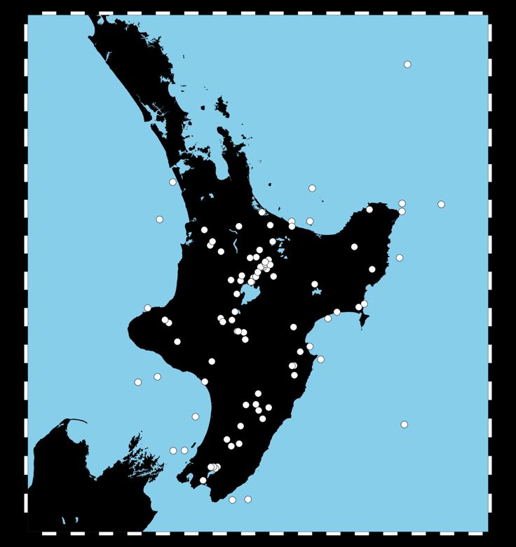
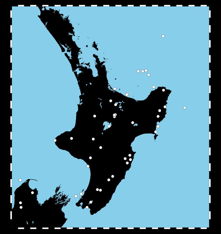
Figure 2: An example high quality ground motion detected by the GMC (top) vs a poor quality ground
motion (bottom).

For a comparison between the GeoNet earthquake catalogue and the automated location procedure (Section
3.1), we have selected data from the first week of January 2011, the year of the MW 6.2 Christchurch
earthquake. As an example, on 2 January 2011, 87 events are provided in the GeoNet catalogue. Our
automated approach identified and located 110 events (Figure 3). Of these events, 55 have closely matched
origin times within 10 seconds. Many stations were not included in this test, particularly from the South
Island. Further matches will be possible with refinement of the association and location parameters and the

Paper 61 – Development and implications of an expanded national earthquake catalogue for New Zealand
NZSEE 2021 Annual Conference
inclusion of all stations with phase detections. Over half of the GeoNet solutions for this date have operator
assigned depth values, while our results provide depth constraint based on location within a 3-D velocity
structure. As an added advantage, our location method also includes computation of the corrected ML
(Rhoades et al., 2020) as part of the automated process.

Figure 3: Comparison of GeoNet earthquake epicentres (left) to the new automated catalogue (right) for 2
January 2011. Note that many of the stations were not used for the automated solutions, but will be included
as the project matures.

5   CONCLUSION
The expanded earthquake and ground motion catalogues are in the earliest stages of development. As
procedure is firmly implemented and thoroughly tested, we plan to analyze the back-catalogue of data from

Paper 61 – Development and implications of an expanded national earthquake catalogue for New Zealand
NZSEE 2021 Annual Conference
2003 until 2020. Once completed, we plan to implement regular updates on a weekly or monthly basis to the
established catalogue. The complete earthquake catalogue will expand on our understanding of regional
hazards, with ground motion intensity measures providing a means of assessing site response to various
styles and distances from rupture.
Further objectives include extending the regional CMT catalogue to lower magnitudes and to develop
detailed regional seismic tomography models. A greater number of CMT solutions will inform fault rupture
models. Higher resolution seismic tomography will lead to more accurate locations and inform hazard
models.

6    REFERENCES
Ancheta, T. D., Darragh, R. B., Stewart, J. P., Seyhan, E., Silva, W. J., Chiou, B. S. J., Wooddell, K. E., Graves, R. W.,
  Kottke, A. R., Boore, D. M., et al. (2014). NGA-West2 database. Earthquake Spectra, 30(3), 989–1005.
  https://doi.org/10.1193/070913EQS197M
Bannister, S., Fry, B., Reyners, M., Ristau, J., and Zhang, H. (2011). Fine-scale relocation of aftershocks of the 22
  February Mw 6.2 Christchurch earthquake using double-difference tomography. Seismological Research Letters,
  82(6), 839–845. https://doi.org/10.1785/gssrl.82.6.839
Bradley, B. A. (2019). On-going challenges in physics-based ground motion prediction and insights from the 2010–2011
  Canterbury and 2016 Kaikoura, New Zealand earthquakes. Soil Dynamics and Earthquake Engineering, 124, 354–
  364. https://doi.org/10.1016/j.soildyn.2018.04.042
Dempsey, D., Eccles, J. D., Huang, J., Jeong, S., Nicolin, E., Stolte, A., Wotherspoon, L., and Bradley, B. A. (2020).
  Ground motion simulation of hypothetical earthquakes in the upper North Island of New Zealand. New Zealand
  Journal of Geology and Geophysics. https://doi.org/10.1080/00288306.2020.1842469
Dupuis, M., Schill, C., Lee, R., and Bradley, B. (2020). A neutal network for ground motion quality classification from
  New       Zealand     earthquakes    of    variable    magnitudes     and     tectonic  types.    Retrieved      from
  https://ir.canterbury.ac.nz/handle/10092/101432
Eberhart-Phillips, D., Bannister, S., Reyners, M., and Henrys, S. (2020). New Zealand Wide model 2.2 seismic velocity
  and Qs and Qp models for New Zealand. https://doi.org/10.5281/ZENODO.3779523
Font, Y., Kao, H., Lallemand, S., Liu, C. S., and Chiao, L. Y. (2004). Hypocentre determination offshore of eastern
  Taiwan using the maximum intersection method. Geophysical Journal International, 158(2), 655–675.
  https://doi.org/10.1111/j.1365-246X.2004.02317.x
Guo, H., and Zhang, H. (2017). Development of double-pair double difference earthquake location algorithm for
  improving        earthquake    locations. Geophysical    Journal     International,   208(1),     333–348.
  https://doi.org/10.1093/gji/ggw397
Heimann, S., Kriegerowski, M., Isken, M., and Cesca, S. (2017). Pyrocko-An open-source seismology toolbox and
  library.                      Retrieved                       from                       https://gfzpublic.gfz-
  potsdam.de/pubman/faces/ViewItemFullPage.jsp?itemId=item_2280895_2
Heimann, S., Isken, M., Kühn, D., Sudhaus, H., and Steinberg, A. (2018). Grond: A probabilistic earthquake source
  inversion              framework.               Retrieved               from               https://gfzpublic.gfz-
  potsdam.de/pubman/faces/ViewItemFullPage.jsp?itemId=item_3615907_6
Kaiser, A., Van Houtte, C., Perrin, N., Wotherspoon, L., and Mcverry, G. (2017). Site characterisation of GeoN et stations
  for the New Zealand strong motion database. Bulletin of the New Zealand Society for Earthquake Engineering, 50(1),
  39–49. https://doi.org/10.5459/bnzsee.50.1.39-49
Krischer, L., Megies, T., Barsch, R., Beyreuther, M., Lecocq, T., Caudron, C., and Wassermann, J. (2015). ObsPy: a
  bridge for seismology into the scientific Python ecosystem. Computational Science & Discovery, 8(1), 014003.
  https://doi.org/10.1088/1749-4699/8/1/014003
de la Torre, C. A., Bradley, B. A., and Lee, R. L. (2020). Modeling nonlinear site effects in physics-based ground motion
   simulations of the 2010–2011 Canterbury earthquake sequence. Earthquake Spectra, 36(2), 856–879.
   https://doi.org/10.1177/8755293019891729
Mousavi, S. M., Ellsworth, W. L., Zhu, W., Chuang, L. Y., and Beroza, G. C. (2020). Earthquake transformer—an
  attentive deep-learning model for simultaneous earthquake detection and phase picking. Nature Communications,
  11(1). https://doi.org/10.1038/s41467-020-17591-w

Paper 61 – Development and implications of an expanded national earthquake catalogue for New Zealand
NZSEE 2021 Annual Conference
Noy, I., Parker, M., and Wood, A. (2016). The Canterbury rebuild five years on from the Christchurch earthquake. Reserve
  Bank of New Zealand Bulletin, 79(3), 3. Retrieved from https://www.questia.com/library/journal/1G1-452290686/the-
  canterbury-rebuild-five-years-on-from-the-christchurch
Rhoades, D. A., Christophersen, A., Bourguignon, S., Ristau, J., and Salichon, J. (2020). A Depth-Dependent Local
  Magnitude Scale for New Zealand Earthquakes Consistent with Moment Magnitude. Bulletin of the Seismological
  Society of America. https://doi.org/10.1785/0120200252
Ristau, J., Harte, D., and Salichon, J. (2016). A revised local magnitude (ML) scale for New Zealand earthquakes. Bulletin
   of the Seismological Society of America, 106(2), 398–407. https://doi.org/10.1785/0120150293
Thurber, C., and Eberhart-Phillips, D. (1999). Local earthquake tomography with flexible gridding. Computers &
  Geosciences, 25(7), 809–818. https://doi.org/https://doi.org/10.1016/S0098-3004(99)00007-2
Waldhauser, F., and Ellsworth, W. L. (2000). A double-difference earthquake location algorithm: method and application
 to the northern Hayward fault, California. Bulletin of the Seismological Society of America, 90(6), 1353–1368.
 https://doi.org/https://doi.org/10.1785/0120000006
Wassermann, J., Barsch, R., Beyreuther, M., Behr, Y., Megies, T., and Krischer, L. (2010). ObsPy: A Python Toolbox
 for Seismology. Seismological Research Letters, 81(3), 530–533. https://doi.org/10.1785/gssrl.81.3.530
White, M. C. A., Fang, H., Nakata, N., and Ben-Zion, Y. (2020). PyKonal: A python package for solving the eikonal
 equation in spherical and cartesian coordinates using the fast marching method. Seismological Research Letters, 91(4),
 2378–2389. https://doi.org/10.1785/0220190318
Zhang, H., and Thurber, C. H. (2003). Double-difference tomography: The method and its application to the Hayward
  Fault,    California.   Bulletin   of  the     Seismological   Society  of   America,      93(5),    1875–1889.
  https://doi.org/10.1785/0120020190
Zhu, W., Mousavi, S. M., and Beroza, G. C. (2019). Seismic Signal Denoising and Decomposition Using Deep Neural
  Networks.      IEEE     Transactions   on    Geoscience     and    Remote     Sensing,  57(11),    9476–9488.
  https://doi.org/10.1109/TGRS.2019.2926772

Paper 61 – Development and implications of an expanded national earthquake catalogue for New Zealand
NZSEE 2021 Annual Conference
You can also read