DigitalGlobe Satellite and Product Overview - JACIE Workshop - September 2017 - USGS
←
→
Page content transcription
If your browser does not render page correctly, please read the page content below

DigitalGlobe Satellite and Product Overview
                                    JACIE Workshop – September 2017

Tokyo, Japan| 6 November 2016 | Worldview-4 | 30cm Resolution   DigitalGlobe Proprietary and Business Confidential   1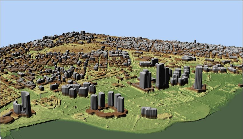
DigitalGlobe: What We Do

DigitalGlobe…
•   Collects the best commercial satellite images
    of the earth in the world
    - 5 satellites capturing imagery at true 30-50 cm
      resolution with exceptional positional accuracy
    - Up to 16 bands of V/NIR and SWIR spectral data +
      image-enhancing CAVIS
    - 90+ PB of imagery back to 1999, 70 TB of new imagery
      collected each day
    - Future DG constellation (Scout/Legion/WV-150) will
      further diversify our capabilities
•   Provides offline imagery and hosted online
    subscriptions via DG Cloud Services
•   GBDx Platform - for exploiting full spectral
    imagery + OS + 3rd party data
                                                    DigitalGlobe Proprietary. ©DigitalGlobe. All rights reserved.   2
DigitalGlobe: What We Do (cont.)

DigitalGlobe…
•   Provides adjacent imagery and data processing options
    - DigitalGlobe Radiant – New Services /Analytic Branch of
      DigitalGlobe
    - Combining with MDA soon adding satellite and radar
      capabilities
    - Variety of High Accuracy Global Elevation Products –
      (3D, DSM, DTM, Point Cloud , etc.)
    - Tomnod / GeoHive crowdsourcing
    - Value-added information and analytic product offerings

      …in order to…
      Create and maintain a digital inventory of the Earth
      …to then...
      Provide multi-INT, predictive analysis to answer specific
      customer questions
                                                                  DigitalGlobe Proprietary. ©DigitalGlobe. All rights reserved.   3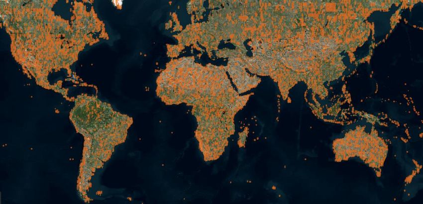
DigitalGlobe’s 5-Satellite Constellation
    ~4,000,000 km2 collected EVERY DAY
         13,200,000,000,000 pixels

     All True 30-50 cm Spatial Resolution
     Multi- and Super-Spectral Capabilities
                                       DigitalGlobe® Proprietary and
4                                               Business Confidential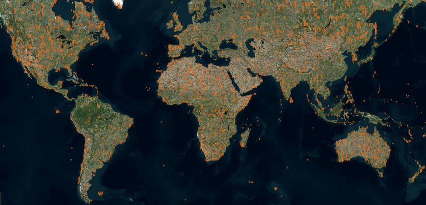
Last 3 Days
      5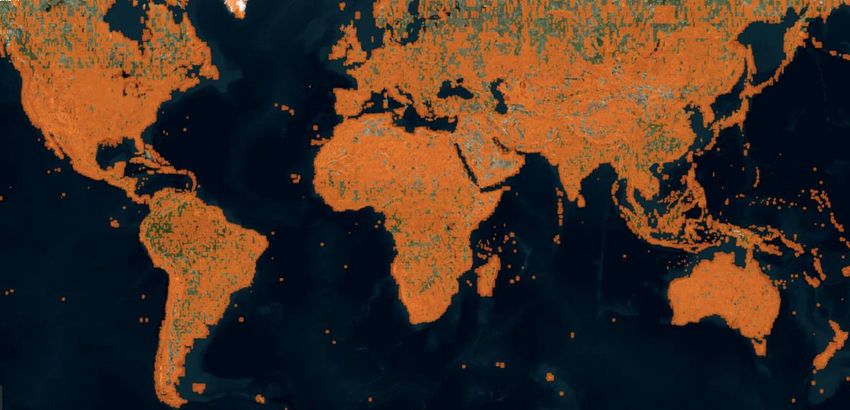
Last 14 Days
      6
Last 3 Months
      7
WorldView-4 –
Capability Overview

                      Orbit:                  617 km, 1:30 pm sun sync
                      Resolution /            0.31 m / Panchromatic
                      Spectral bands:         1.24 m / 4 Multispectral
                      Nadir swath:            13.1 km
                      Line rates:             12k/3k lps
                                              20k/5K lps
                                              24k w/MS aggregated in-track
                      Global capacity:        640,000 sq km/day
                      Geolocation spec:       5.0 m CE90 (w/o GCPs)
LM Heritage Bus
                      Design life:            7 years
  High agility        Expected life:          10-12 years
   platform           Propellant life:        15-50 years for 770-500 km
                      Reliability:            Ps ≥ 0.53 @7 years
Exelis Instrument
                      Mass:                   2510 kg (454 kg propellant)
 High resolution
  panchromatic        Array / battery:        3.75 kW / 312 Ahr
+ 4 Multispectral     Image storage:          3.2 Tbits
      bands           Image downlink:         800 Mbps (695 + EDAC)
                                              Simultaneous w/imaging

                                        DigitalGlobe Proprietary and Business Confidential   8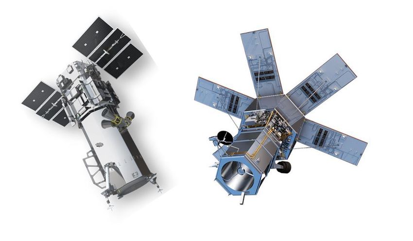
WorldView-4 more than doubles our 30cm capacity

    •   WorldView-4 collections are ramping to build an Archive for
        customer ordering

                       By flying in tandem “1 + 1 = more than 2”

           WorldView-3                                             WorldView-4

                            WorldView-4 frees up WorldView-3 for
                                 additional SWIR collections
9       APAC Engage - WorldView-4                      9/25/2017   DigitalGlobe Proprietary and Business Confidential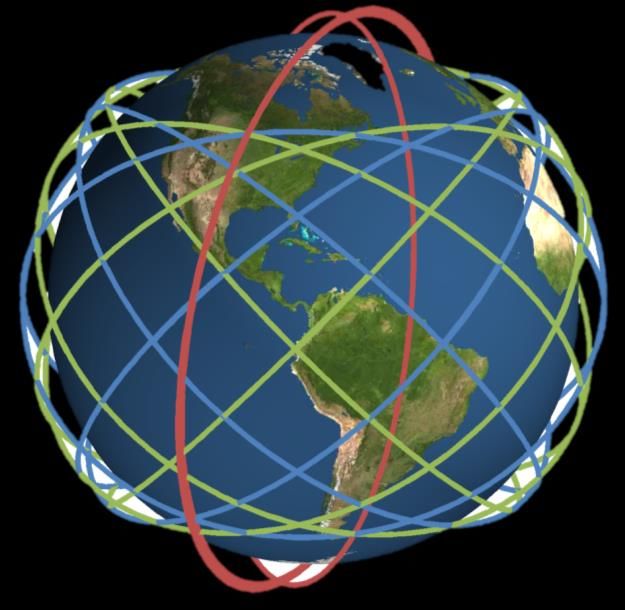
Our Future DG Constellation Will Diversify our Capabilities
     Preliminary capabilities to be refined with customer and vendor input

                    • Constellation developed via Joint Venture with TAQNIA Space &
                      KACST
  Scout             • 6 spacecraft on orbit in 2018/19 timeframe
                    • ~80cm ground sampling distance (GSD)
                    • Mid-latitude orbits (tbd)

                    •   Will replenish WorldView-1/2
                    •   6 spacecraft on orbit in 2020/21 timeframe
  Legion            •   ~35-50cm GSD
                    •   Mix of sun-synchronous and mid-latitude orbits

                    •   Will replenish WorldView-3/4
WorldView-          •   1-2 spacecraft estimated to orbit in 2025/26 timeframe
   150              •   ~30cm GSD
                    •   Sun-synchronous orbit (tbd)
                                                                                      10
           Emerging view; final specifications to be refined.
Our DG Constellation Roadmap Will Extend Our
Industry Leadership Well into the Next Decade
Satellite ’13 ’14 ’15 ’16 ’17 ’18 ’19 ’20 ’21 ’22 ‘23
WorldView-1
GeoEye-1
WorldView-2
WorldView-3
WorldView-4
Scout Constellation
Legion Constellation
WorldView-150
On Orbit 2025/26
Spacecraft on orbit Planned spacecraft
11Scout and Legion will be on Mid-Latitude Orbits Which
will Significantly Enhance our Revisit Capabilities
Current WorldView constellation is in Future constellation mixes sun-sync and
sun-sync orbits mid-latitude orbits for greater revisit
WorldView Orbit – red Scout Orbit – blue
Legion Orbit – green
WorldView Orbit – red
With Scout + Legion, revisit improves by more than 10x
Orbit tracks shown are a preliminary illustration of Scout and Legion at mid-lat orbits, final specifications are yet to be defined. 12DigitalGlobe Elevation
See a better world.
Libya| 0.5m | Vricon – Digital Surface ModelDigitalGlobe’s Elevation Suite
1 Traditional
Stereo Imagery –
DIY Elevation
Advanced
2
Elevation Series
(AES) – Full
service Project
Specific Digital
Elevation Models
Vricon Wide area Rapid
Delivery 3D and Elevation
3 – Mutiview
Photogrammetry Derived
from Archive
14 9/25/2017 DigitalGlobe Proprietary and Business ConfidentialDigitalGlobe’s Elevation Suite
4 NTT Advanced World
Elevation (AW3D) –
‘Off the Shelf’ 5m
Global Elevation
Models
& High-Res Enhanced
DSMs/DTMs globally
available at 50cm, 1m
and 2m resolutions
15 9/25/2017 DigitalGlobe Proprietary and Business ConfidentialThe Geospatial Big Data Platform
(“GBDX”)
Bring innovation & compute to the data…
Location
Intelligence
DigitalGlobe
Library
GBDX
Open
Source
Content
Other
Commercial Subscription
Imagery Access
Sources
…to extract location intelligence at mission
relevant speeds & scale
DigitalGlobe® Proprietary and
16 Business ConfidentialDG Recommendations for USG Support
Spatial
• Need USG help re: the relaxation of spatial resolution and data collection
restrictions
₋ Including 3.7m for SWIR deliverables
₋ Allow the ability to collect SWIR data globally and not just certain areas of the
globe
₋ 15-20cm is another standard for imagery globally and the USG should consider
aspects for spatial resolution relaxation
• Some commercial satellite imagery firms are resampling imagery from
80cm to 50cm
₋ The USG could help industry by maintaining MTF targets for sub-meter
resolution and NIIRS interpretation.
DigitalGlobe Proprietary. ©DigitalGlobe. All rights reserved. 17DG Recommendations for USG Support
Spectral
• USG can continue to assist in maintaining programs for radiometric
calibration including SWIR
₋ USG should continue to offer access to test/cal-val ranges; control data, DEMs
etc. for satellite collection
Temporal
• DigitalGlobe will be introducing new revisit capability with inclined orbits
₋ The USG could help to initiate a Study with universities to ensure the image
quality for mapping and spectral analysis missions and what parameters can
specifically help with programs such as USDA NAIP, USGS 3DEP, etc.
DigitalGlobe Proprietary. ©DigitalGlobe. All rights reserved. 18DG Recommendations for USG Support
Global support
• When commercial firms introduce new technologies to the marketplace:
₋ Industry needs help from the USG to help expedite any required USG approval processes
₋ Regulatory restrictions require us to severely degrade the quality of imagery for customers,
despite having requested permission to sell full-resolution 3.7m SWIR imagery (for fire
assessment, etc.) more than three years ago.
₋ USG needs to put more focus on evaluating and adding these new technology products as
alternatives to traditional methods that cost the U.S taxpayer multiple times as much.
• Concept of cyber security
₋ Industry can benefit from better guidance from USG to insure that delivery of value-added
information /output products cannot fall into the wrong hands leading to reverse-engineered;
₋ What can USG do to help commercial data firms protect original source data?
• The U.S. Census, USDA and USGS have global-focused missions
₋ Would be beneficial for USG agencies to help promote benefits of SWIR band technology and
other commercial capabilities jointly.
• Remote sensing has changed the concepts of map making
₋ The USG should help industry from being constrained by use of certified surveyors for imagery
use.
₋ The USG can continue to help by supporting independent evaluation of various sensors - both
domestic and foreign sensors and imagery
DigitalGlobe Proprietary. ©DigitalGlobe. All rights reserved. 19Summary
• DigitalGlobe’s imagery, platform, and analytic capabilities help to
address USG and other global customer application needs and
project requirements
- DigitalGlobe satellite, aerial, and open-source data
- High-speed, multi-partner processing ecosystem and crowd sourcing
capabilities at massive scale (GBDX)
- Variety of high-res, high-accuracy elevation products (Vricon, AES, AT3W)
- Value-added analytic capabilities and information products
• DigitalGlobe stands ready to work with & support USG Agency
program activity
Brett Thomassie
Director, U.S. Federal Civilian Govt. Programs
Bthomassie@digitalglobe.com
(303) 588-4129
DigitalGlobe Proprietary. ©DigitalGlobe. All rights reserved. 20You can also read