Disastrous Mechanism of Water Burst by Karst Roof Channel in Rocky Desertification Mining Area in Southwest China
←
→
Page content transcription
If your browser does not render page correctly, please read the page content below

Hindawi
Geofluids
Volume 2022, Article ID 7332182, 9 pages
https://doi.org/10.1155/2022/7332182

Research Article
Disastrous Mechanism of Water Burst by Karst Roof Channel in
Rocky Desertification Mining Area in Southwest China

          Jie Suo,1 Qirong Qin,1 Wenqiang Wang,2,3 Zhenhua Li ,2,3 Cunhan Huang,2,3 Youlin Xu,4
          and Zuguo Chen5
          1
            School of Geoscience and Technology, Southwest Petroleum University, Chengdu, 610500 Sichuan, China
          2
            School of Energy Science and Engineering, Henan Polytechnic University, Jiaozuo, 454000 Henan, China
          3
            Collaborative Innovation Center of Coal Work Safety and Clean High Efficiency Utilization, Jiaozuo, 454000 Henan, China
          4
            Institute of Mining Engineering, Guizhou Institute of Technology, Guiyang, 550003 Guizhou, China
          5
            Xintian Coal Mine, Yonggui Energy Development Co., Ltd., Qianxi, 551500 Guizhou, China

          Correspondence should be addressed to Zhenhua Li; jzlizhenh@163.com

          Received 22 April 2021; Revised 7 February 2022; Accepted 5 March 2022; Published 18 March 2022

          Academic Editor: Jia Liu

          Copyright © 2022 Jie Suo et al. This is an open access article distributed under the Creative Commons Attribution License, which
          permits unrestricted use, distribution, and reproduction in any medium, provided the original work is properly cited.

          With the development of coal mining in rocky desertification mining area in Southwest China, water burst is becoming an
          important disaster in coal mine. In order to grasp the evolution characteristics of water gushing channels in coal mining in
          rocky desertification mining area, the 1402 working face in Xintian Coal Mine is taken as the research object, and the
          occurrence of aquifers on the roof of the working face is analyzed, and the water filling path of the aquifers is explored.
          Besides, the evolution characteristics of water passage in coal seam mining are comprehensively analyzed, by the methods of
          physical similarity simulation, numerical simulation, and microseismic monitoring. The results show that the key water
          resource is the atmospheric precipitation, which enters the mine through the original karst fissure and mining-induced fissure.
          With the continuous advance of working face, the fracture height of overburden increases gradually. Specifically, when the
          advancement distance of working face exceeds 135 m, the water-conducting cracks in the overlying strata develop to the
          bottom boundary of the Yulongshan limestone aquifer, and then, the mining-induced fracture and aquifer are conducted;
          when the working face advances 190 m, the overall overburden mining fissure is divided into fissure opening zone and fissure
          closed zone. Meanwhile, most of the microseismic events occur in the middle part of the karst roof, and the maximum height
          of microseismic event is 40 m away from the bottom boundary of the Yulongshan limestone, during the advancing process of
          the working face. When the mining fissure is connected with the original karst fissure, atmospheric precipitation enters the
          aquifer through the original karst fissure and enters the gob of working face through the mining fissure. The research results
          provide the references for prediction and prevention for the water burst disaster in rocky desertification mining area in
          Southwest China.

1. Introduction                                                        When mining coal seams in karst mining areas, roof karst
                                                                       water seriously threatens the safe and efficient mining of coal
As one of the most important coal bases in Southwest China,            in mines [6, 7]. Therefore, it is of great significance to study
Guizhou is known as the “Southwest Coal Sea” [1, 2]. At the            the evolution characteristics of water gushing channels in
same time, it is also the largest and most concentrated area           karst roof of mining areas, which is beneficial for guiding
of karst distribution in China. The exposed area of limestone          coal mining in rocky desertification mining area in South-
reaches 73% of the total area of the province [3, 4]. The              west China.
underground karst fissures are highly developed in this area.               Many scholars at home and abroad have done lots of
Most of the atmospheric rainfall are not stored on the sur-            research work on the development height and characteristics
face, which flows into the underground karst aquifer [5].               of the water-conducting fracture zone in the karst coal roof.
2                                                                                                                    Geofluids

In terms of the development characteristics and laws of the      tion technology to obtain the development height of water-
water-conducting fractured zone, researchers represented         conducting fracture zone in fully mechanized caving mining
by Liu Tianquan [8] have summarized and obtained the             under thick loose layer and weak overburden. In terms of
empirical formula for the development height of the water-       water flow height prediction, Shi et al. [23, 24] combined
conducting fractured zone through years of field research         principal component analysis (PCA), genetic algorithm
and analysis; Qiao et al. [9] systematically summarized the      (GA), and optimized Elman neural network to establish
research progress of aerosol water from four aspects, namely,    PCA-GA-Elman for the height prediction of water flow frac-
the formation mechanism of roof aerosol water, disaster-         ture zone development. Based on neural network algo-
causing mechanism, water disaster prediction and early           rithms, Z. H. Li et al. [25] selected mining thickness,
warning, and key prevention and control technologies; Yang       mining depth, working face inclination length, coal seam
and Xu [10] comprehensively employed the methods of the-         inclination, and overlying rock structure characteristics as
oretical analysis, similar material tests, and numerical simu-   the main influencing factors for the height of the water-
lation to obtain the evolution law of the water-conducting       conducting fissure zone. Based on the particle swarm
fracture zone in a large mining height face; Lai et al. [11]     (POS)-support vector regression (SVR) research method,
used physical similar material simulation experiments, com-      Xue et al. [26] constructed the Ordos Basin Jurassic coal field
bined with the total station and borehole peep monitoring,       water-transmitting fractured zone height prediction model.
3DEC, and SPSS statistical analysis software, and obtained            The above research results have an important guiding
the migration law of overlying strata in coal seam mining,       significance for coal mining under water bodies, but there
the development and evolution of fractures, and the distri-      are few studies on the development height and development
bution characteristics of water-conducting fracture zones;       rules of water-conducting fissures in karst mining areas [27,
Zou et al. [12] used FLAC3D software to calculate and ana-       28]. This paper employs a combination of theoretical analy-
lyze the plastic failure zone, displacement field, and stress     sis, similarity simulation, numerical simulation, and field
field distribution characteristics of the surrounding rock        microseismic monitoring to analyze the source and volume
above the stope before and after the fully mechanized caving     of water inrush from coal seam mining in karst areas.
work passes the fault and obtained the formation mecha-          Through similarity simulation and numerical simulation,
nism of the water channel; Wang et al. [13] used theoretical     the process of connection between the water conduction fis-
analysis and field detection to obtain the characteristics of     sures and the original karst fissures is proved, and the water
the development height of roof water-conducting fractures        inrush model for coal seam mining in karst areas is pro-
under the influence of the key layer structure with the min-      posed, and the coal seam mining in karst mining areas is
ing thickness, and the development height is affected by both     mastered. Therefore, the evolution characteristics of roof
the mining thickness and the key layer structure; Zhang et al.   water gushing channels provide an important reference for
[14–16] used the theory of elastic foundation beams to           safe and efficient coal mining in rocky desertification mining
establish a mechanical analysis model for the height of the      area in Southwest China.
overburden water-conducting fissure zone of the block-
filled stope; Zhu et al. [17] built a coal seam mining model
in the karst cave area and obtained the development charac-      2. Mining and Hydrogeological Conditions
teristics of roof mining cracks during coal seam mining;
Wang et al. [18] used similarity simulation and theoretical      2.1. Water Source of Mine Water Filling. Xintian Mine is
analysis to propose a composite mechanism model of “elas-        located in Qianxi County, Bijie City, Guizhou Province. This
tic thin plate” and “parallel pressure arch” for the migration   area is a typical karst mining area. Mine water is mainly
of overlying strata in high-strength mining under three-         filled with two major water sources, namely, atmospheric
dimensional spatial conditions; Liu et al. [19] used the bore-   precipitation and underground karst water. Atmospheric
hole television system and borehole simple hydrological          precipitation is the main source of replenishment for surface
observation method, combined with similarity simulation          water and underground karst water, which restricts the
and numerical simulation, and obtained the development           dynamic changes in the flow of surface rivers and mines.
characteristics of the overlying water-conducting fissure         According to the meteorological data provided by the Qianxi
zone in fully mechanized caving mining in deep and extra-        County Meteorological Bureau, the annual rainfall in the
thick coal seams. In terms of the height of the water-           mining area is about 940~1090 mm, and the rainy season
conducting fissure zone, Y. P. Zhang et al. [20] used a com-      is from May to September, accounting for about 80% of
bination of field measurement, numerical simulation, and          the annual rainfall. Under normal circumstances, atmo-
similarity simulation to obtain the overburden failure height    spheric precipitation mainly replenishes the Yulongshan
of the deep thick coal seam in the west of Mongolia with the     limestone aquifer through shallow weathering fissures,
large mining height; Guo et al. [21] used the method of on-      structural fissures, and sinkholes. Continuous rainfall
site ground drilling flushing fluid leakage and theoretical        increases the water supply to the underground Yulongshan
analysis methods to obtain the height of the water-              limestone aquifer, so atmospheric precipitation is the direct
transmitting fracture zone in top coal mining under soft         water source for filling water in the shallow limestone aqui-
and hard alternate overburden conditions; Yang et al. [22]       fer of the mine. When the mining fissure is connected to the
comprehensively used downhole borehole water injection           aquifer, the aquifer becomes a direct source of water for the
loss observation, borehole television, and numerical simula-     mine.

Geofluids                                                                                                                        3

    The water richness of the aquifer in the Yulongshan sec-      nal model, the loading value is
tion of the Yelang Formation in the mining area is generally
not strong and extremely uneven. However, affected by the                                  P
                                                                                   qp =     = γp ðH − H l Þ:                  ð1Þ
structure of the fault and lateral fracture zone, the karst is                            F
strongly developed, and the underground karst space is con-
nected with the surface karst, especially during rainfall.           The load value qm on the model is
Atmospheric precipitation and surface water leak along sur-
face creeks and sinkholes to replenish the ground, resulting                                qp     γ ðH − H 1 Þ
                                                                                  qm =            = P           ,             ð2Þ
in a large amount of groundwater enrichment in the lime-                                  CL ⋅ Cγ     CL ⋅ Cγ
stone aquifer in the Yulongshan section, which becomes an
enrichment zone for groundwater. The lower part contains          where qp is the prototype unsimulated rock formation
the limestone of the Changxing Formation with an average
thickness of 35 m. Because there is a water barrier in the        pressure, KPa; H is the mining depth, m; H 1 is the height
middle, and the stratum is not exposed, deep buried, and          of the simulated roof rock formation, m; the thickness of
poor replenishment conditions, the limestone of the               the unsimulated overburden is 280 m, where the average
Changxing Formation is a weak aquifer.                            bulk density of the overburden is 2800 KN/m3; and the
                                                                  load qm applied to the model is 3484 KPa. This load is
2.2. Mine Water Filling Channel. The water-filled channel in       compensated by the pressure of the hydraulic column on
the karst mining area is composed of the original karst fis-       the test bench. Two displacement measuring lines are
sures and mining fissures, which is different from the              arranged on the model, a total of 48 displacement measur-
water-filled channels in ordinary mining areas only by the         ing points, and each measuring point is 10 cm apart. The
mining fissures. The original fissures include weathered            1# measuring line is located at the interface of the lime-
zones, faults, collapse pits, sinkholes, and underground karst    stone top plate of the Changxing Formation, and the 2#
fissures. Mining fissures are the fractures formed by the col-      measuring line is located at the interface of the limestone
lapse of the roof of underground coal mining, forming the         floor of the Changxing Formation. In order to eliminate
water-filling channel of the karst mining area. When the           the influence of the boundary, 30 m coal pillars are left
mining fissures and karst fissures are connected, karst water       on the left and right sides of the model, and the excava-
continuously flows into the well, seriously affecting the safe      tion is carried out gradually from right to left, shown in
and efficient mining of the working face.                           Figure 2.
                                                                      This experiment uses sand as aggregate, calcium carbon-
2.3. Overview of Test Working Face. The 1402 working face         ate and gypsum as cementing materials, and borax as
of Xintian Coal Mine is selected as the test working face,        retarder. According to the calculation method of the simu-
which has a strike length of 147 m and a slope length of          lated strength value of similarity materials, a reasonable ratio
1148 m. The average mining thickness of the coal seam is          of similarity materials in each layer is obtained. According to
3 m, and the average inclination angle is 3°. The working face    the cross-sectional area of the model frame, the thickness of
elevation is +912~+948 m. The working face is located to the      the rock (coal), and the geometric similarity ratio, the weight
north of the three main lanes in the south wing, 1401 mined       of the similarity material of each rock (coal) layer is calcu-
area on the east, 1404 unmined working face on the west,          lated (considering the richness factor of 1.2), and the pro-
1402 bottom extraction lane under 1402 belt transport lane,       portion number and parameters are shown in Table 1.
and original 1# bottom extraction under 1402 track trans-         3.2. Development Characteristics of Water Gushing Channels
port lane. The surface is barren hills, and the buried depth
is more than 340 m, and the mining has little impact on           3.2.1. Fracture Characteristics of Overlying Strata. The min-
the ground. The layout of 1402 working face is shown in           ing method of oblique mining is adopted in the 1402 work-
Figure 1.                                                         ing face. During the mining process, collapse, subsidence,
                                                                  and layer separation occur in sequence above the gob. When
3. Similarity Simulation of Evolution                             the working face advances to 85 m, the overburden fracture
   Characteristics of Water Gushing Channel                       occurs for the fifth cycle. The overburden collapse height is
                                                                  24 m, and the fracture angle on the side of the working face
3.1. Model Design and Establishment. According to the min-        is 55°, which is smaller than the fracture angle at the open
ing geological conditions of the 1402 working face, the           cut. The lower part contains the limestone of the Changxing
buried depth of working face is about 340 m, and the min-         Formation. There are a large number of separation zones,
ing thickness of the coal seam is only 3 m. In consider-          and the mining cracks do not penetrate the limestone of
ation, if the similarity ratio is small, the geometric            the Changxing Formation; when the working face advances
similarity ratio is selected as 1 : 100; and the length, width,   to 150 m, the overburden fracture occurs in the ninth cycle.
and height of the selected similarity simulation test bench       The overburden fracture height is 85 m, and the fracture
are2500 mm × 200 mm × 1300 mm, and the simulated rock             angle on the side of the working face is 56°, and the fracture
layer height is 120 m. According to similarity simulation         angle at the open cut is 60°, and the fracture angle between
principles, the top loading of the model fails to simulate        the two fracture lines is 60°. The strata span is 80.6 m, and
the weight of the rock formation. According to the origi-         the mining fissures have fully developed to the top of the
4                                                                                                                                                        Geofluids

                                                                                    1404 unmined
                                            Stop mining line                         working face

                                            Stop mining line    Advancing                              1402 golf
                                                                 direction

                                            Stop mining line                                           1401 golf

                                               Figure 1: Schematic layout diagram of 1402 working face.

                                             Uniform load (3484 kPa)
                                                                                                                          Loading cylinder
                                                           20 m              10 m      1#line       Model
                                             Mudstone
                                                                                                    front

                                Changxing    Formation     35 m        Displacement
                                                                      measuring point 2#line                                            4# coal seam
             120 m

                                Limestone
                                                               30 m
                                  Sand and mudstone                           4#coal seam
                                                                                         Coal
                       Coal                                                              pillar
                       pillar                                                                       Model
                                                                                                    reverse
                       30 m                               190 m                          30 m
                     Stop mining line                                               Open-off cut

                                   Figure 2: Displacement measuring point arrangement and excavation position.

                                                Table 1: Similarity simulation test ratio and parameters.

                                Thickness       Matching               Compressive strength              Tensile strength            Cohesion          Density (g/
No.      Lithology
                                  (cm)          number                       (MPa)                           (MPa)                    (MPa)              cm3)
         Sand and
1                                  20               655                         29.9                               2.31                 9.91             2.770
         mudstone
2        Limestone                 35               437                         51.4                               5.70                 17.12            2.800
         Sand and
3                                  30               655                         29.9                               2.31                 9.91             2.770
         mudstone
4         4# Coal                   3               773                          3.9                               0.28                 1.23             1.461
         Sand and
5                                  32               655                         29.9                               2.31                 9.91             2.770
         mudstone

model, indicating that the fracture height of the fissures has                              During the excavation of the working face, the over-
reached the Yulongshan limestone floor at this time; when                               burden fracture height is recorded. When the working face
the working face advances to 190 m, the overburden fracture                            advances to 95 m, the overburden fracture height is 45 m,
occurs for the thirteenth cycle. The fracture angle on the side                        and the limestone of the Changxing Formation has been
of the working face is 52°, and the fracture angle at the open                         fractured; when the working face advances to 110 m, the
cut is 60°, and the strata span between the two fracture lines                         Changxing Formation is completely broken; when the
is 132.6 m. The fractured height of the fissure has reached                             working face advances to 135 m, the overburden fracture
the inside of Yulongshan limestone. When the 4# coal seam                              height is 85 m, indicating that the cracks have developed
is excavated, there are 13 periodic roof breaks in the over-                           to the top of the model. Due to the size of the model, with
burden. The first break step is 35 m, and the average periodic                          the further excavation of the coal seam, the height of the
break step is 11.9 m. The mining fissures are connected to                              overburden cracks no longer changes on the model. How-
the Yulongshan limestone aquifer, shown in Figure 3.                                   ever, the limestone of the Yulongshan section gradually
Geofluids                                                                                                                                    5

                                                                                                        80.6 m
                                            Separation
                                               zone
                                                                                               85 m
                                            24 m                      4#
                                   55°                   62.5°       coal                                              60°
                                                                                      56°
                               5th periodic failure                              9th periodic failure

                                     (a) Excavation 85 m                                      (b) Excavation 150 m

                                                                            132.2 m

                                                                  85 m

                                                                                                             60°
                                      52°                                                                            4# coal

                             13th periodic failure

                                                                 (c) Excavation of 190 m

                                                     Figure 3: Periodic weighting of coal seam.

                                                                                coal seam is obtained. When the working face advances to
Mudstone
                                                                                85 m, the 2# survey line is bent and deformed. At this time,
               Fissure           Fissure                                        the limestone floor of the Changxing Formation breaks and
Changxing                                              Fissure
                                                                                sinks. With the continuous advancement of the working
               opening           closure
formation                                              opening
limestone       zone               zone
                                                        zone                    face, the floor sand and mudstone layers are periodically
Sand and
                                                                                broken. When the coal seam is excavated, the maximum
                            Fissure opening
mudstone                         zone
                                                                                subsidence of the 2# survey line is -1332.1 mm.

                             Excavation direction of                            3.2.3. Fissure Field. The sketch map of the distribution of
                                 working face
                                                                                overburden cracks in the 4# coal seam after mining is shown
                                                                                in Figure 4. The overburden fissure field is divided into fis-
           Figure 4: Fissure field in mining 4# coal seam.                       sure opening area and fissure closure area. The opening
                                                                                angle of the overburden rock near the working face and
breaks in actual conditions, and the mining fissures con-                        the open cut is relatively large, and the fissures are more
tinue to expand into the limestone of the Yulongshan                            developed. The water conductivity is strong, and the upper
section.                                                                        fissures in the middle of the gob are closed due to compac-
                                                                                tion, and the water conductivity is poor. After the coal seam
                                                                                is fully mined, the mining fissures have developed to the top
3.2.2. Displacement of Overlying Rock. The displacement                         of the model and are connected to the Yulongshan limestone
change of the limestone roof in the Changxing Formation                         aquifer. The roof water enters the gob through mining fis-
during the mining process of the 4# coal seam is obtained.                      sures. Because it is inclined mining, the karst water in the
When the working face advances to 110 m, the survey line                        gob flows to the working face, which is consistent with the
begins to bend and deform, indicating that the upper part                       water gushing phenomenon that occurs in the actual coal
of the Changxing Formation limestone begins to bend and                         seam mining process.
sink; when the working face advances to 120 m, the maxi-
mum subsidence value of 1# survey line is -507.3 mm, and
the limestone of Changxing Formation breaks and sinks at                        4. Field Measurement of Breaking Height in
this time; with the continuous advancement of working face,                        Overlying Rock
the displacement curve sinks periodically. After the working
face is mined, the maximum sinking value of the 1# survey                       4.1. Layout of Microseismic Monitoring Points. According to
line is -1006 mm.                                                               the general principle that all measuring points form a spatial
    The displacement change of the limestone floor in the                        body, candidate points for the station layout of the micro-
Changxing Formation during the mining process of the 4#                         seismic monitoring system of Xintian Mine have been
6                                                                                                                                                              Geofluids

                        Ground

                                         Signal processor   Signal storage station            Signal acquisition station       Signal amplifier

                           Underground

                                                                            Rail transport          1        2             3
                                                                                                                                                  Integrated
                                                                              roadway                                                              line box
                                                                                        1402      Downhole vibration pickup
                                            1402
                                            1402 goaf
                                                 goaf
                                                                                     working face     1. 2. 3. 4. 5. 6

                                                            Belt transportation
                                                                  roadway
                                                               100 m              50 m       50 m
                                                                            4            5          6

                             Figure 5: Working principle and schematic diagram of measuring point layout.

       Table 2: Optimal plan for measuring point layout.                                      mation limestone floor, 1 m below the Yulongshan limestone
                                                                                              floor, and 45 m above the Yulongshan limestone floor.
N0.        Location
                                               Coordinate                                         During the monitoring period, microseismic events
                                   X                 Y                       Z                mostly occur on the leading working face. Large energy
1     1402 Track roadway     3001528.013         35608039.428           930.590               events exceeding 100 J are mainly concentrated in the middle
2     1402 Track roadway     3001547.067         35608007.589           921.339               of the working face and lagging behind the working face and
3     1402 Track roadway     3001569.681         35607977.316           913.300               occur in the upper part of the gob behind the working face.
                                                                                              According to the microseismic event profile, the maximum
4      1402 Belt roadway     3001407.313         35607944.994           937.110
                                                                                              height of the microseismic event is located at the Yulong-
5      1402 Belt roadway     3001428.630         35607914.794           931.960               shan limestone 125 m away from the 4# coal seam. There-
6      1402 Belt roadway     3001452.382         35607880.289           925.357               fore, the height of the water gushing channel develops to
                                                                                              the Yulongshan limestone, and the water gushing channel
selected. The schematic diagram of the designed layout of                                     is connected to the Yulongshan limestone cave.
measuring points is shown in Figure 5.
    The optimal plan for the location of the measuring point                                  5. Analysis of Mine Water Inflow Process
determined by analysis and measurement calculation is
shown in Table 2.                                                                             After the working face is fully recovered, there is continuous
                                                                                              water gushing to the working face behind the working face.
4.2. Analysis of Microseismic Monitoring Results. The distri-                                 Temporary water pumps are installed on the working face
bution of microseismic events was monitored from Novem-                                       to pump the water to the storage tank of the stop line. After
ber 11, 2019, to January 5, 2020. The microseismic events                                     the precipitation, it is discharged into the underground silo
mostly occurred in front of the work and were mostly biased                                   through the water pump, shown in Figure 6.
towards the 1402 belt lane, and the energy range was in the
range of 0~1000 J. There were only four microseismic events                                   5.1. Analysis of Mine Water Inflow. By analyzing the average
in the mined-out area behind the working face, with energy                                    monthly water inflow from April 2015 to October 2019 and
three times greater than 1000 J.                                                              the atmospheric rainfall data in the area, the relationship
    The cross-sectional view of the microseismic event in the                                 between atmospheric rainfall and mine water inflow is
track lane at 1402 working face is obtained. The microseis-                                   obtained, shown in Figure 7. The change in mine water
mic event gradually decreases in the front of the working                                     inflow is closely related to atmospheric rainfall, indicating
face, but the energy of the event increases as it goes up.                                    that there is a water inflow channel between the mine and
There are three locations in front of the work where the                                      the ground, resulting in an increase in mine water inflow
energy of the microseismic event exceeds 100 J. One of them                                   after atmospheric rainfall.
is the bottom of the Changxing Formation limestone, and
the remaining two are located inside the Yulongshan lime-                                     5.2. Mine Water Gushing Process. Based on the hydrogeolo-
stone. The two locations are 5 m and 45 m away from the                                       gical conditions of the mining area, a conceptual model of
bottom boundary of the Yulongshan rock formation, and                                         karst roof gushing water is proposed, shown in Figure 8.
the highest point is 125 m from the roof of 4# coal seam.                                     There are many bead-shaped sinkholes on the surface. The
    The section view of the microseismic event at the 1402                                    limestone karst fissures in the upper part of the Yulongshan
working face is obtained. During the monitoring period,                                       section are relatively developed, and the karst fissures in the
the upper rock formations at the 1402 working face have                                       lower part are poorly developed. Gas and rain tend to enter
four relatively large vibrations, all with energy greater than                                underground karst caves and karst fissures through sink-
100 J. Moreover, the locations of the incidents are basically                                 holes and surface karst cracks, becoming a potential threat
near the vertical line of the working face. The positions from                                to coal mining. Xintian Coal Mine mainly mines the 4#
bottom to top are as follows: 3 m below the Changxing For-                                    and 9# coal seams. With the increase of the mining space
Geofluids                                                                                                                                                                                                                   7

                                                                   Working face      Reservoir                           Reservoir      Drainage ditch

                                                                                         Drainage pipe
                                                                                        for working face

                                                                                   Artesian tube
                                                                                                                              Artesian tube

                                                                                    Figure 6: Underground gushing and drainage situation.
           The amount of water gushing in the mine (m3/h)

                                                                                                                                                                            The amount of atmospheric precipitation (mm)
                                                            300                                                                                                       300
                                                            270                                                                                                       270
                                                            240                                                                                                       240
                                                            210                                                                                                       210
                                                            180                                                                                                       180
                                                            150                                                                                                       150
                                                            120                                                                                                       120
                                                             90                                                                                                       90
                                                             60                                                                                                       60
                                                             30                                                                                                       30
                                                              0                                                                        0
                                                                  2 4 6 8 10 12 2 4 6 8 10 12 2 4 6 8 10 12 2 4 6 8 10 12 2 4 6 8 10 12
                                                                     2015          2016          2017          2018          2019

                                                                    The amount of water gushing in the mine
                                                                    The amount of atmospheric precipitation

                                                              Figure 7: The relationship between mine water inflow and atmospheric rainfall in Xintian Mine.

                                                                                                                Rain
                                                                                                 Sinkhole

                                                                                                                         Infiltration
                                                                                                                Side                           Water-bearing
                                                                  Strong aquifer                               supply                           karst cave

                                                                                                              Vertical
                                                                  Weak aquifer                                artesian

                                                                  Mudstone Layer

                                                                                        Water storage              Vertical
                                                                  Weak aquifer         space in the goaf           artesian

                                                                                                                                                         Water Tank

                                                                        Figure 8: Conceptual model of water inrush from karst roof in coal mining.
8                                                                                                                            Geofluids

of the 4# coal seam, the mining fissures gradually develop          [2] Z. W. Liu, M. Q. Zhang, and S. R. Wang, “Catastrophe predic-
upwards, and the original fissures further develop and                  tion and treatment technology of karst tunnel,” Second edition,
expand under the influence of mining.                                   Beijing: Science Press, vol., vol. 2007, 2007.
    When the distance between the coal seam and the aqui-          [3] Z. Z. Cao, Y. L. Ren, Q. T. Wang, B. H. Yao, and X. C. Zhang,
fer reaches the critical value of water gushing, the original          “Evolution mechanism of water-conducting channel of col-
karst fissures and mining fissures are connected to form a               lapse column in karst mining area of Southwest China,” Geo-
water gushing channel between the surface-karst cave-                  fluids, vol. 2021, 2021.
working face or gob. When 4# coal seam is mined in Xintian         [4] Y. Xue, J. Liu, P. G. Ranjith, Z. Zhang, F. Gao, and S. Wang,
Mine, the working face is threatened by roof karst water, and          “Experimental investigation on the nonlinear characteristics
the mining work of 9# coal seam is also threatened by roof             of energy evolution and failure characteristics of coal under
karst water.                                                           different gas pressures,” Bulletin of Engineering Geology and
                                                                       the Environment, vol. 81, no. 1, article ???, 2022.
                                                                   [5] J. Liu, Y. Xue, Q. Zhang, H. Wang, and S. Wang, “Coupled
6. Conclusion                                                          thermo-hydro-mechanical modelling for geothermal doublet
                                                                       system with 3D fractal fracture,” Applied Thermal Engineering,
    (1) Atmospheric precipitation in karst areas is the key            vol. 200, article 117716, 2022.
        supply water source for the Yulongshan limestone           [6] P. Hou, Y. Xue, F. Gao et al., “Effect of liquid nitrogen cooling
        aquifer, which enters the mine through the original            on mechanical characteristics and fracture morphology of
        karst fissure and mining-induced fissure. Besides,               layer coal under Brazilian splitting test,” International Journal
        the Yulongshan limestone aquifer is the direct source          of Rock Mechanics and Mining Sciences, vol. 151, p. 105026,
        of water gushing in the mine                                   2022.
    (2) There are ultrahigh-conductivity fracture zones in         [7] Y. Xue, J. Liu, P. G. Ranjith, X. Liang, and S. Wang, “Investiga-
        coal seam mining in karst mining areas. When the               tion of the influence of gas fracturing on fracturing character-
                                                                       istics of coal mass and gas extraction efficiency based on a
        working face advances 135 m, the fissure develops
                                                                       multi-physical field model,” Journal of Petroleum Science and
        to the Yulongshan limestone floor. With the contin-             Engineering, vol. 206, article 109018, p. 109018, 2021.
        uous advancement of the working face, the height of
                                                                   [8] State Coal Industry Bureau, “Coal pillars and coal mining reg-
        the water-conducting fissure zone continues to                  ulations for buildings, water bodies, railways and main shafts,”
        develop upwards. The final monitoring results show              Beijing: Coal Industry Press, vol. 2000, no. 1, pp. 225–233,
        that the development height of water-conducting fis-            2000.
        sure zone is 125 m                                         [9] W. Qiao, Z. W. Wang, W. P. Li et al., “The formation mecha-
    (3) When the 4# coal seam is fully mined, the mining               nism, hazard mechanism and prevention technology of coal
        fissure is connected to the karst fissure, and a water           mine roof separation water damage,” Journal of China Coal
                                                                       Society, vol. 46, no. 2, pp. 507–522, 2021.
        gushing channel is formed between the surface, the
        karst cave, and the working face (or gob). On this        [10] Y. L. Yang and G. G. Xu, “Evolution of water-transmitting
        basis, a conceptual model of karst roof gushing in             fault zone in large mining height working face under Luohe
                                                                       sandstone aquifer,” Coal Mine Safety, vol. 52, no. 3, pp. 30–
        coal mining in rocky desertification mining area is
                                                                       35, 2021.
        proposed
                                                                  [11] X. P. Lai, X. D. Zhang, P. F. Shan, F. Cui, B. W. Liu, and R. Bai,
                                                                       “Development law of water-conducting cracks in overlying
Data Availability                                                      strata in mining of three-soft coal seams under thick loose
                                                                       layers,” Chinese Journal of Rock Mechanics and Engineering,
The data used to support the findings of this study are                 vol. 40, no. 9, pp. 1739–1750, 2021.
included within the article.
                                                                  [12] G. H. Zou, C. Zhang, D. Tian et al., “Research on the formation
                                                                       mechanism of the water channel through the overlying strata
Conflicts of Interest                                                  of the fault group in fully mechanized caving face,” Metals
                                                                       and Minerals, vol. 539, no. 5, pp. 65–70, 2021.
The authors declare that they have no conflicts of interest.       [13] X. Z. Wang, J. L. Xu, H. K. Han, J. F. Ju, and Y. T. Xing,
                                                                       “Stepped development characteristics of roof water-
Acknowledgments                                                        conducting fissure height with mining thickness,” Journal of
                                                                       China Coal Society, vol. 44, no. 12, pp. 3740–3749, 2019.
This work was supported by the National Natural Science           [14] Y. Zhang, S. Cao, T. Wan, and J. Wang, “Field measurement
Foundation of China (52174073, 41972175, and 51774110)                 and mechanical analysis of height of the water flowing fracture
and the Natural Science Foundation of Henan Province                   zone in short-wall block backfill mining beneath the aquifer: a
(222300420007).                                                        case study in China,” Journal of Mining & Safety Engineering,
                                                                       vol. 2018, no. 1, pp. 1–12, 2018.
References                                                        [15] Y. Zhang, S. G. Cao, X. P. Lai et al., “Analysis of the
                                                                       mechanical characteristics of the development of water-
 [1] S. J. Wang, “Discussion on the concept deduction of karst         transmitting fractures in the overlying rock in short-wall
     rocky desertification and its scientific connotation,” China        block mining,” Journal of China Coal Society, vol. 45,
     Karst, vol. 2002, no. 2, pp. 31–35, 2002.                         no. S2, pp. 551–560, 2020.
Geofluids                                                                  9

[16] Y. Zhang, S. G. Cao, X. P. Lai, C. Z. Zhao, and S. Y. Du,
     “Research on development mechanism and control of water-
     conducting fissures in overlying rock in short-wall block-
     filling mining,” Journal of Mining & Safety Engineering,
     vol. 36, no. 6, pp. 1086–1092, 2019.
[17] C. Q. Zhu, D. G. Cui, Z. Zhou, Q. F. Li, and Y. J. Huang, “Sim-
     ilarity simulation of mining fissure development and cave fail-
     ure characteristics in karst mining area,” Chinese Journal of
     Underground Space and Engineering, vol. 15, no. 1, pp. 93–
     100, 2019.
[18] Y. G. Wang, W. B. Guo, E. H. Bai et al., “Study on the charac-
     teristics and mechanism of overlying strata migration in high-
     strength mining,” Journal of China Coal Society, vol. 43, no. s1,
     pp. 28–35, 2018.
[19] Y. F. Liu, S. D. Wang, and X. L. Wang, “Development charac-
     teristics of water conducting fracture zone in overlying strata
     in fully mechanized caving mining in deep and extra-thick coal
     seam,” Journal of China Coal Society, vol. 39, no. 10, pp. 1970–
     1976, 2014.
[20] Y. P. Zhang, Y. G. Zhang, Y. T. Liu, Y. J. Song, and Q. Y. Zhao,
     “Research on overburden failure height of large-cutting height
     fully mechanized face in deep thick coal seam in western
     Mengxi,” China Safety Science Journal, vol. 30, no. 8, pp. 37–
     43, 2020.
[21] W. B. Guo, G. Z. Lou, and B. C. Zhao, “Research on the height
     of water-conducting fracture zone in top coal caving mining
     with soft and hard overlying strata in Lugou coal mine,” Jour-
     nal of Mining & Safety Engineering, vol. 36, no. 3, pp. 519–526,
     2019.
[22] D. M. Yang, W. B. Guo, G. B. Zhao, Y. Tan, and W. Q. Yang,
     “Development height of water-conducting fracture zone in
     fully mechanized caving mining under thick loose layer and
     weak overburden,” Journal of China Coal Society, vol. 44,
     no. 11, pp. 3308–3316, 2021.
[23] L. Q. Shi, H. B. Wu, Y. L. Li, and W. K. Li, “PCA-GA-Elman
     optimization model for predicting the development height of
     water-conducting fracture zone,” Journal of Henan Polytechnic
     University (Natural Science Edition), vol. 40, no. 4, pp. 10–18,
     2021.
[24] L. Q. Shi, H. Q. Xin, P. H. Zhai et al., “Study on the calculation
     of the height of the water conducting fracture zone under the
     condition of large mining depth,” Journal of China University
     of Mining and Technology, vol. 41, no. 1, pp. 37–41, 2012.
[25] Z. H. Li, Y. C. Xu, L. F. Li, and C. Z. Zhai, “Prediction of the
     height of water conducting fracture zone based on BP neural
     network,” Journal of Mining & Safety Engineering, vol. 32,
     no. 6, pp. 905–910, 2015.
[26] J. K. Xue, H. Wang, C. H. Zhao, J. Yang, Z. F. Zhou, and D. B.
     Fang, “Prediction of the height of water-transmitting fissure
     zone and roof water filling mode of Jurassic coalfield in Ordos
     Basin,” Journal of Mining & Safety Engineering, vol. 37, no. 6,
     pp. 1222–1230, 2020.
[27] Y. Xue, J. Liu, X. Liang, S. Wang, and Z. Ma, “Ecological risk
     assessment of soil and water loss by thermal enhanced meth-
     ane recovery: numerical study using two-phase flow simula-
     tion,” Journal of Cleaner Production, vol. 334, article 130183,
     p. 130183, 2022.
[28] Z. Z. Cao, Y. F. Xue, H. Wang, J. R. Chen, and Y. L. Ren, “The
     non-Darcy characteristics of fault water inrush in karst tunnel
     based on flow state conversion theory,” Thermal Science,
     vol. 25, no. 6, pp. 4415–4421, 2021.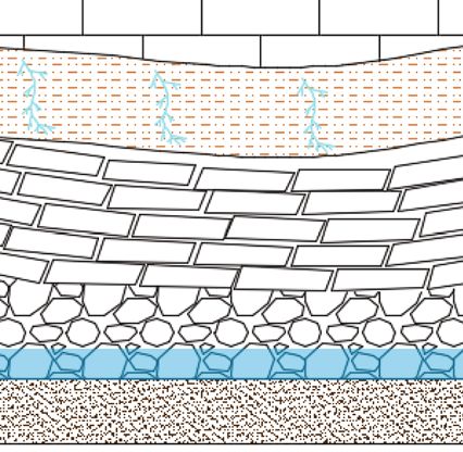
You can also read