Division Street Redevelopment Needs Study Neptune Township Monmouth County, NJ - Prepared by
←
→
Page content transcription
If your browser does not render page correctly, please read the page content below
Division Street Redevelopment Needs Study
             Neptune Township
           Monmouth County, NJ

                    Prepared by

       _______________________________________

           Jennifer C. Beahm, P.P., AICP
           New Jersey License No. 05625
                 Original is Sealed

                                                 Page 1
Table of Contents
                                                                           Page
1.0   Introduction                                                            3
      1.1   Goals and Objectives of the Redevelopment Designation             5
      1.2   Scope of Study                                                    5
      1.3   Redevelopment Process                                             5
      1.4   Report Sections                                                   6
2.0   Study Area Characteristics                                              7
      2.1   Tax Block and Lots & Location Description                         7
      2.2   Regional Setting / Transportation                                 9
      2.3   Existing Zoning                                                   9
      2.4   Relevant Planning Studies                                         10
      2.5   State Planning Area Classification                                11
      2.6   Existing Land Uses                                                11
      2.7   Environmental Assessment                                          12
3.0   Statutory Criteria                                                      13
      3.1   Application of Statutory Criteria                                 14
4.0   Study Area Evaluation                                                   16
      4.1   Study Approach                                                    16
      4.2   Study Findings and Recommendations                                16
5.0   Conclusion                                                              19
6.0   Appendices                                                              20
            Appendix A: C-6 Route 33 East Commercial District Code            21
            Appendix B: Photos of Study Area                                  26
            Appendix C: Enlarged Map of Study Area                            41
            Appendix D: Report of Geophysical Survey for 129 Division Street 43
            Appendix E: Pre-Demolition Asbestos Inspection Report for 129     49
                          Division Street
            Appendix F: Federal Insurance Rate Map Containing Study Area      70
            Appendix G: Survey Of Property, Block 173 Lots 27.01 To 39.01, by 72
                          Leon S. Avakian, Inc.
            Appendix H: Division Street Subdivision Plan, by Neptune Township 74
            Appendix I: New Jersey Police Crash Investigation Reports for     76
                         Streets Near Study Area.

                                                                         Page 2
1.0       INTRODUCTION

This Determination of the Area in Need of Redevelopment Study has been prepared by
CME Associates (“CME’) on behalf of the Neptune Township (“Township”) Planning
Board to determine whether the study area meets the criteria necessary to declare it as
“An Area In Need of Redevelopment.” The subject area (“Study Area”) is identified as
Block 173, Lots 27.01 through 39.01 by the Township’s tax records, with Lot 29 being
excluded as it is currently occupied.

This study serves to formally assess the Study Area to determine whether it should be
designated a Non-Condemnation Redevelopment Area under Section 40A:12A-5 of the
State of New Jersey’s Local Redevelopment and Housing Law (LRHL). If the Study
Area is designated a Non-Condemnation Redevelopment Area, the Township will not be
authorized to acquire property in the Non-Condemnation Redevelopment Area via
eminent domain. Redevelopment, pursuant to NJSA 40A: 12A-1 et. Seq., is a planning
tool used to fulfill the goals of rebuilding abandoned and/or underutilized properties,
increasing tax rateables, improving the local economy, and improving the appearance of
the community. Redevelopment also enables municipalities to provide short (5 years)
and long term (30 years) tax abatement programs.

A particular parcel or area qualifies for redevelopment if it meets at least one criterion of
the eight statutory criteria that are listed in Section 5 of the State’s Local
Redevelopment and Housing Law (LRHL). These criteria and the degree to which the
parcels within this Study Area in the Township meet these criteria are outlined in detail
within Section 3.0 of this Report. In preparation of the study, the following records and
documents were reviewed:

      •   Official Tax Maps of Neptune Township;
      •   Property Survey of Block 173 Lots 27.01 to 39.01, Prepared by Leon S. Avakian,
          Inc., Dated July 20, 2012;
      •   Division Street Subdivision Plan, Prepared by Leanne R. Hoffman, PE, PP, CME,
          Dated March 31, 2014;
      •   Tax records for the Study Area properties;
      •   Aerial photos of the Study Area;
      •   Ownership and sales information;
      •   Neptune Township Master Plan;
      •   New Jersey Police Crash Investigation Reports (Appendix I);
      •   Zoning Map and Ordinance of Neptune Township;

                                                                                       Page 3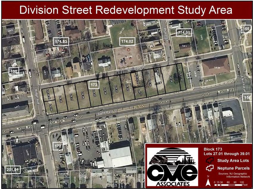
•   NJ DEP data via the NJ GeoWeb tool;
   •   Report titled ”Pre-Demolition Asbestos Inspection Report” for ACM Inspection
       conducted at 129 Division Street, Neptune Township, NJ, prepared by Sky
       Environmental Services, Inc., dated October 18, 2013 (Appendix E);
   •   Report titled “Report of Geophysical Survey” for geophysical investigation
       conducted at 129 Division Street, Neptune Townhip, NJ, prepared by Dynamic
       Earth, dated September 30, 2013 (Appendix D);
   •   FEMA Flood Insurance Rate Maps (Appendix F); and
   •   The New Jersey State Development and Redevelopment Plan.

In addition, an analysis of land use, occupancy based on visual findings and physical
conditions was conducted for each of the properties through on-site observation of the
Study Area.

Recent Redevelopment Law to Consider: Court Decisions
A municipality has broad discretion in designating a particular parcel as being “in need
of redevelopment” pursuant to the LRHL, Concerned Citizens of Princeton, Inc. v.
Mayor and Council of the Borough of Princeton. Recent case law narrowing the
application of criteria (d) and (e) of the LRHL does not disturb the historic and significant
deference given to a municipality’s finding that a particular area is in need of
redevelopment and underscores that such a finding carries great legal significance.

On September 6, 2013, the Legislature amended the LRHL to provide that a
municipality must determine whether an area in need of redevelopment will be subject
to eminent domain at the very beginning of the redevelopment process. Now, when
determining whether an area should be designated as “in need of redevelopment”, the
municipality must indicate whether it is seeking to designate a “Non-Condemnation
Redevelopment Area” or a “Condemnation Redevelopment Area”. The criteria for each
type of area are the same; the only difference is the power to use eminent domain.

Ordinance Regulating Use of Eminent Domain Powers
Neptune Township’s General Ordinance Section 2-62 governs the Township’s use of
Eminent Domain powers. The Section states that the Township may use its authority for
public use or public purpose or “where the public health, safety or welfare has been
determined to be at issue and condemnation is the last and/or best process for
correcting the situation”. The Section also identifies redevelopment areas that are

                                                                                       Page 4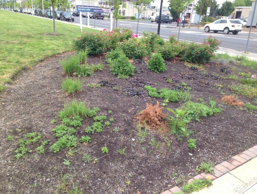
subject to special conditions and exceptions with regard to use of Eminent Domain, and
procedures for implementation of Eminent Domain.

1.1       GOALS AND OBJECTIVES OF THE REDEVELOPMENT DESIGNATION
The goal of this redevelopment designation is to subdivide the fifteen parcels existing
within the Study Area (described in Section 2 below) into twenty-five parcels, of which
seventeen will contain new single-family houses affordable to low- and moderate-
income households, and seven will contain berm and buffer easements separating the
units from State Highway Route 33. The remaining parcel will remain as is, as it is
currently contains an occupied single-family home that will be excluded from
redevelopment.

1.2       SCOPE OF STUDY
This Needs Study is designed to explore the need as well as opportunities to revitalize
the site included within the Study Area through redevelopment projects and involves the
following steps:
      •   Conduct an inventory of the properties included within the Study Area and
          physical characteristics of the same.

      •   Depict to what extent the existing characteristics and conditions meet the criteria
          to determine the need for redevelopment, as outlined within the State statutes.

      •   Propose findings and recommendations relevant to the determination of the need
          for redevelopment of the Study Area.

1.3       REDEVELOPMENT PROCESS
The role of the Governing Body and Planning Board: The redevelopment statute sets
forth a multi-step process that must be observed by the Committee and Planning Board
in order to enable the Township to lawfully exercise the powers which accrue as a result
of employment of redevelopment planning. This process is outlines below.

      •   The Governing Body must authorize, by resolution, an investigation of the
          delineated area to determine whether it meets the criteria in section 5 of
          P.L.1992, c.79 (C.40A:12A-5).

      •   The Planning Board must hold a duly noticed public hearing in order to discuss
          the findings of the investigation and to hear persons who are interested in or

                                                                                        Page 5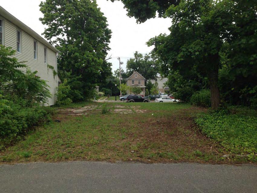
would be affected by the contemplated action.             The results and
          recommendations of the hearing are then referred to the governing body in the
          form of a Planning Board resolution for formal action.

      •   Upon receipt of the recommendation from the Planning Board, the Governing
          Body may act to adopt a resolution designating the area in question, or any part
          thereof, as an area in need of redevelopment.

      •   Upon designation, the Planning Board or Redevelopment Entity is then required
          to prepare a redevelopment plan, which establishes the goals and objectives of
          the municipality and outlines the actions to be taken to accomplish these goals
          and objectives.

      •   The redevelopment plan, after review by the planning board, is referred to the
          governing body.

      •   Upon receipt of the redevelopment plan from the planning board, the governing
          body may act to adopt the plan by ordinance. The adopted plan may become an
          amendment to the municipality’s zoning district map and zoning ordinance or
          may be treated as an overlay to existing zoning. Only after completion of this
          public process is a municipality able to exercise the powers granted under the
          redevelopment statute.

1.4       REPORT SECTIONS
Apart from the Introduction, this Report contains four sections. The first section
describes the Study Area in terms of its location, existing zoning, relevant planning
studies, existing land uses and environmental assessment. The second section reviews
and applies the statutory criteria and sets forth the findings based upon the observed
and analyzed characteristics and conditions. The third section provides an overview
and evaluation of the properties within the Study Area, based upon the field
observations and photographic evidence. The fourth section provides recommendations
to Neptune Township relative to determining the redevelopment needs of the area.
The New Jersey Redevelopment Statute does not require that all properties in the Study
Area be in need of redevelopment; but rather that a majority or generality of properties
meet the criteria for determination. As a result, the area may include individual parcels
that do not reflect any of the eligibility criteria listed in the Statute.

                                                                                     Page 6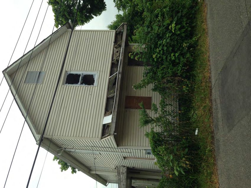
2.0   STUDY AREA CHARACTERISTICS

2.1   TAX BLOCK AND LOTS & LOCATION DESCRIPTION

This report relies upon a property survey prepared by Leon S. Avakian, Inc. (Appendix
G), provided by the Neptune Township, which illustrates the delineations and general
features of the parcels within the Study Area. The Division Street Redevelopment
Needs Study Area (“Study Area”) is comprised of Lots 27.01 through 39.01 on Block
173 in Neptune Township (“Township”), and contains a total of 1.678 acres of through
lots abutting NJ Route 33 (“Rte 33”) and Division Street. All but lots 31, 31.01, 39, and
39.01 are through-lots. Division Street runs parallel to Rte 33 for approximately 860 feet
(the Study Area itself comprises approximately 610 feet of this length), and is bound on
its east and west ends by Atkins Avenue (County Route 5) and Ridge Avenue,
respectively.

Description of Study Area

Properties in the Study Area mostly consist of vacant, unimproved parcels. Per the
Division Street Subdivision Plan (Appendix H), the Township intends to subdivide the

                                                                                     Page 7
existing lots into 25 lots, and to change the existing tax block number from 173 to 512.
The table below outlines our findings for each of the lots under their current lot number,
and indicates the lot numbers into which they will be subdivided. Photos of some of the
lots are included in Appendix B of this report.

Table 1: Property Descriptions

 Current
 Lot   # Proposed Lot
                       Description                                                     Ownership
 (Block  # (Block 512)
 173)
 27.01      18, 20               Vacant                                                Neptune
            16 through 18,
 28                        Vacant, with a dirt/gravel driveway
            20                                                                         Neptune
                           Occupied 2.5 story house, ground floor area
                           approximately 675 s.f., with a 75 s.f. porch. To
 29         15
                           remain. Gravel driveway continues from Lot 28,
                           around back of house, into Lot 30                           Private
                           Vacant, with gravel driveway, continued from Lots
                           28 and 29. Approximate 10 foot planted buffer
 30         13, 14, 21
                           separating current lot 30 from current lot 31 and
                           31.01.                                                      Neptune
 31         22             Vacant                                                      NJDOT
                           Vacant 2.5 story house, ground floor area
                           approximately 750 s.f., with an approximately 100
 31.01      12, 13         s.f. porch. The lot also contains a concrete
                           driveway. Windows boarded up, shattered where
                           exposed.                                                    Private
                           Vacant, with concrete pad either as foundation or
 32         10,11,12,23
                           accessory use                                               Neptune
                                 Vacant, with planted buffers 1.) along fence to Lot
 33         9, 10, 24
                                 32, and 2.) within the lot, by lot line to lot 34     State
                                 Vacant, with dirt driveway and frontage line
 34         7, 8, 9, 24
                                 plantings                                             NJDOT
                                 Vacant, with dirt driveway and frontage line
 35         6, 7, 25
                                 plantings                                             Neptune
 36         5, 6, 25             Vacant                                                Neptune
 37         3, 4, 25             Vacant                                                Neptune
 38         2, 3, 25             Vacant                                                Neptune
                                 Planted flower garden, and sign advertising new
 39
            1, 26                townhomes that are located at Ridge and Embury        State
 39.01      1                    Vacant                                                State

                                                                                                 Page 8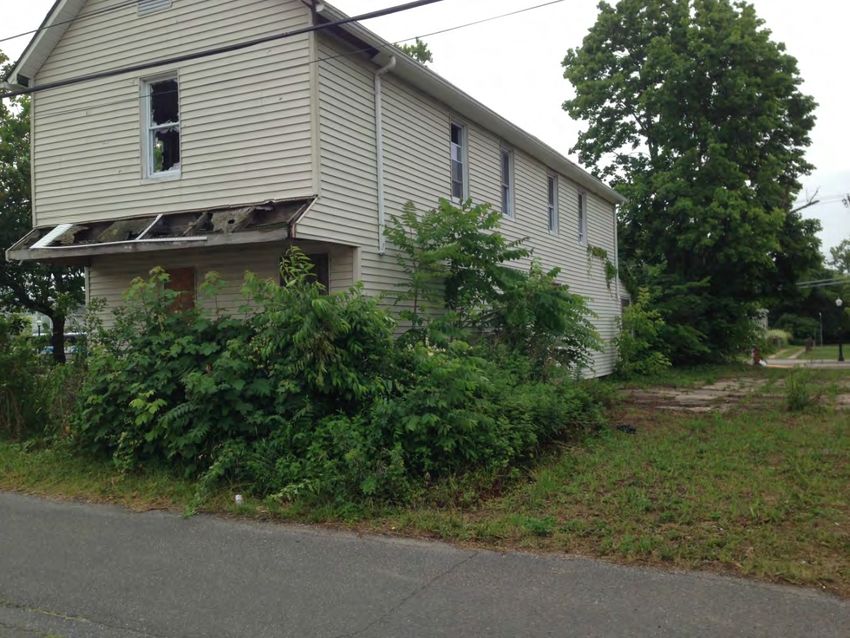
2.2   REGIONAL SETTING / TRANSPORTATION

Neptune Township is located in on the eastern side of Monmouth County. Though it has
over half a mile of coastal frontage, the Township extends inland nearly 5 miles. It
contains approximately 8.8 square miles, and as of the 2010 Census it had a population
of 27,935 persons. Some of its direct neighbors include Bradley Beach, Asbury Park
and Belmar to the East, Wall Township to the South, Tinton Falls Borough to the West,
and Ocean Township to the North.

The Township is intersected by State Routes 18, 33, 66, and 35, and County Roads 17,
5, and 71, among others. Several NJ Transit-operated bus routes pass through the
Township as well. Bus Route 836, for example, operates along Route 33, passing the
Study Area. Other bus routes passing through the Township include 830, 317, 837, 832,
and 317. Rail stations accessible to Neptune residents include the Asbury Park Station
and the Bradley Beach Station along NJ Transit’s New Jersey Coast Line. The
Township’s Senior Center provides transportation services by reservation to local senior
citizens for trips to medical services, food shopping, and other purposes.

2.3   EXISTING ZONING

The zoning of an area indicates uses permitted at a particular property along with
ordinance stipulated standards regarding the building height, lot coverage, parking
requirements etc. In some instances, the zoning ordinances sets forth standards
regarding site design such as lighting and landscaping standards as well as
architectural standards. Neptune is currently zoned into 23 districts. The Study Area is
located in the Township’s C-6 Zoning District.

The purpose of this district stated in the Township’s Land Development Ordinance is to
“[provide] for business uses appropriate to the Route 33 highway corridor of Neptune
Township situated East of Route 18.” The permitted uses listed in the ordinance include
a wide range of retail and professional services, and public and institutional uses.
Residential Uses are not permitted.

Bulk Requirements for this Zoning District are as follows:

                                                                                   Page 9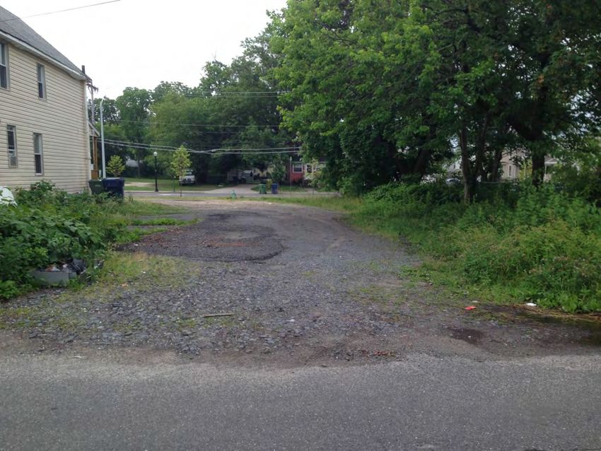
Dimension                       Requirement    Dimension                     Requirement
Minimum Lot Area                15,000 s.f.    Front Yard Setback            15 feet
Maximum Floor Area Ratio        0.6            Side Yard Setback             0/10 feet
Minimum Lot Width               100 feet       Combined Side Yard Setback    25 feet
Minimum Lot Frontage            100 feet       Rear Yard Setback             20 feet
Minimum Lot Depth               100 feet       Maximum Building Coverage     35%
Maximum Total Lot Coverage      80%            Maximum Number of Stories     3
Maximum Building Height         48 feet        Minimum Improveable Area      7,200 s.f.
Minimum Improveable Area:       55 feet
Diameter of Circle

2.4       RELEVANT PLANNING STUDIES

Neptune Strategic Revitalization Plan

The Study Area was included in the Neptune Strategic Revitalization Plan, as part of a
broader study area titled the Crossroads and Southern and Eastern Gateways area.
Recommendations as part of the strategy for improving this area include:

      -   Designating the Route 33 corridor east to Route 71 in need of redevelopment;
      -   Designating remaining properties in need of rehabilitation, which may allow for
          short-term tax abatements on property improvements;
      -   Rezoning to encourage a mix of restaurant, service, retail, and office uses;
      -   Gradually eliminating nonconforming residential uses along the highway;
      -   Establishing building-design standards for future construction to produce a more
          “human scale” environment;
      -   Implementing streetscape improvements to create a more pedestrian friendly
          environment; and
      -   Offering grants, loans, and tax incentives to encourage property owners to
          improve their buildings and to encourage new commercial development on
          vacant lots.

2011 Township of Neptune Comprehensive Master Plan

Neptune Township’s Master Plan sets a range of goals and objectives for the future
development of the Township, a number of which relate to the designation of the Study
Area as In Need of Redevelopment. For example, the Master Plan text notes that the
Township’s 2004 Revitalization Plan discusses Route 33 as an area to target for
redevelopment. The text notes that the corridor contains a number of vacant parcels,
and that “…there is a desire to not create strip commercial and similar auto dependent
only commercial uses, but instead to create a vibrant commercial corridor in close
proximity to residential properties.” Other goals and objectives relevant to the Study
Area and the Township’s vision for developing affordable housing in the area include:

                                                                                     Page 10
• “Provide a variety of housing opportunities for all income levels in appropriate
locations consistent with environmental constraints”
• “Guide the redevelopment and development of the remaining large parcels and
scattered vacant sites within neighborhoods to ensure proposed uses support
existing uses without adverse impact in terms of land use compatibility, traffic,
economic, and aesthetic impacts”
2.5 STATE PLANNING AREA CLASSIFICATION
The New Jersey State Development and Redevelopment Plan (SDRP) classifies
Neptune Township as a Planning Area 1 (PA-1) Metropolitan Planning Area. The
primary objective of the SDRP is to guide development to areas where infrastructure is
available or can be readily extended. The State Plan is intended to provide for much of
the state’s future development, promote growth in cities, and other compact forms,
protect the character of existing stable communities, protect natural resources, redesign
areas of sprawl and revitalize cities and towns.
The PA-1 Metropolitan Planning Areas encompass major urban centers, towns that
developed around commuter rail and highways to metropolitan centers, and shore
towns such as Neptune Township. Most PA-1 Areas enjoy significant public and private
sector investment, and amenities ranging from recreational facilities to educational
institutions and these areas are typically nearly fully developed. Redevelopment in PA-1
communities is the primary form in which land use changes will occur. The State Plan’s
intentions for Metropolitan Planning Areas are:
- Provide for much of the state’s future redevelopment;
- Revitalize cities and towns;
- Promote growth in compact forms;
- Stabilize older suburbs;
- Redesign areas of sprawl; and
- Protect the character of existing stable communities.
2.6 EXISTING LAND USES
The Study Area consists mostly of vacant land. As indicated in Table 1, Lot 29 contains
an occupied, single-family house, and Lot 31.01 contains an abandoned single-family
house. Lots 28 and 30 have a gravel driveway crossing through them, but no other
improvements, and Lot 32 contains a concrete pad of which the purpose or source is
not clear.
Surrounding uses
Page 11Lot 24, at the corner of Atkins Avenue and Division Street, contains a small commercial
building with multiple storefronts including a pharmacy. Parking for this building is
located on Lot 26, also excluded from the Study Area. Properties on the north side of
Division Street include 2.5 story houses that are occupied by single families or multiple,
unrelated tenants, and a small playground. Properties opposite Rte 33 include
residential houses and businesses. Across Atkins Avenue is the Midtown Community
Elementary School, and across Ridge Avenue is Corlies Plaza, a two story office
building.
2.7 Environmental Assessment
We have conducted a preliminary due diligence effort to determine the potential
environmental liabilities, which may be present within, as well as proximate to the Study
Area (e.g. underground storage tanks). According to data available through NJDEP’s
GeoWeb tool, the properties included in the Study Area are not Known Contaminated
Sites, Groundwater Contamination Areas (CKE or CEA), or Underground Storage Tank
Facilities. They do not contain or intersect with wetlands or other environmentally
sensitive water or land areas. According to the Flood Insurance Rate Map developed by
FEMA for this area, the Study Area is located in Flood Zone X, meaning it is outside of
the 500 year flood plain. See the Flood Insurance Rate Map attached in Appendix F.
Neptune had employed the services of private companies in September and October of
2013 to conduct a geophysical investigation and an asbestos-containing materials
(ACM) inspection at 129 Division Street, aka Lot 31.01, where there exists a vacant
single-family house. The ACM inspection confirmed that the kitchen and the front area
of the house contained ACMs, and recommended that these materials be properly
removed and abated prior to demolition of the house. The geophysical investigation
found that the front and side yards of the property contained buried objects containing
or constructed with metal, which the investigators concluded were likely to be piping and
septic tank infrastructure. These reports are attached in Appendices D and E.
Page 123.0 STATUTORY CRITERIA
The laws governing redevelopment by municipalities in New Jersey are set forth in the
Local Redevelopment and Housing Law, which is codified at N.J.S.A. 40A:12A et seq.
This statute grants the governing body of the municipality the power to authorize the
Planning Board to conduct a study to determine whether an area is in need of
redevelopment; to make such a determination following the completion of the study; and
to adopt a redevelopment plan for the designated area. Such an area may be
determined to be in need of redevelopment only if, after an investigation by the Planning
Board and a public hearing for which notice has been given, it is found to meet one or
more of the following conditions:
a. The generality of buildings are substandard, unsafe, unsanitary, dilapidated or
obsolescent, or possess any of such characteristics, or are so lacking in light, air
or space, as to be conducive to unwholesome working or living conditions.
b. The discontinuance of the use of buildings previously used for commercial,
manufacturing or industrial purposes; the abandonment of such buildings; or the
same being allowed to fall into so great a state of disrepair as to be untenantable.
c. Land that is owned by the municipality, the county, a local housing authority,
redevelopment agency or redevelopment entity, or unimproved vacant land that
has remained so for a period of ten years prior to adoption of the resolution, and
that by reason of its location, remoteness, lack of means of access to developed
sections or portions of the municipality, or topography, or nature of the soil, is not
likely to be developed through the instrumentality of private capital.
d. Areas with buildings or improvements which, by reason of dilapidation,
obsolescence, overcrowding, faulty arrangement or design, lack of ventilation,
light and sanitary facilities, excessive land coverage, deleterious land use or
obsolete layout, or any combination of these or other factors, are detrimental to
the safety, health, morals or welfare of the community.
e. A growing lack or total lack of proper utilization of areas caused by the condition
of the title, diverse ownership of the real property therein or other conditions,
resulting in a stagnant or not fully productive condition of land potentially useful
and valuable for contributing to and serving the public health, safety and welfare.
f. Areas, in excess of five contiguous acres, whereon buildings or other
improvements have been destroyed, consumed by fire, demolished or altered by
the action of storm, fire, cyclone, tornado, earthquake or other casualty in such a
way that the aggregate assessed value of the areas has been materially
depreciated.
Page 13g. In any municipality in which an enterprise zone has been designated pursuant to
the “New Jersey Enterprise Zones Act,” P.L. 1983, c.303 (C.52:27H-60 et seq.)
the execution of the actions prescribed in that act for the adoption by the
municipality and approval by the New Jersey Urban Enterprise Zone Authority of
the zone development plan for the area of the enterprise zone shall be
considered sufficient for the determination that the area is in need of
redevelopment pursuant to sections 5 and 6 of P.L. 1992, c.79 (C.40A:12A-5 and
40A-12A-6) for the purpose of granting tax exemptions within the enterprise zone
district pursuant to the provisions of P.L. 1991, c.431 (C.40A:20-1 et seq.) or the
adoption of a tax abatement and exemption ordinance pursuant to the provisions
of P.L. 1991, c.441 (C.40A:21-1 et seq.). The municipality shall not utilize any
other redevelopment powers within the urban enterprise zone unless the
municipal governing body and planning board have also taken the actions and
fulfilled the requirements prescribed in P.L. 1992, c.79 (C. 40A:12A-1 et al.) for
determining that the area is in need of redevelopment or an area in need of
rehabilitation and the municipal governing body has adopted a redevelopment
plan ordinance including the area of the enterprise zone.
h. The designation of the delineated area is consistent with smart growth planning
principles adopted pursuant to law or regulation. In evaluating the above-
referenced statutory criteria, it should be recognized that a redevelopment area
determination cannot be made until all of the properties within a study area are
evaluated against all of the conditions cited above, such that an overall
conclusion can be made with respect to the area.
3.1 APPLICATION OF STATUTORY CRITERIA
The finding that an area is in need of redevelopment is an area-wide determination. As
such, the statutory charge for a positive finding of redevelopment eligibility requires a
demonstration that physical deterioration by the presence of improvements, which are
dilapidated, obsolete and faulty in terms of arrangement, lack of ventilation, light and
sanitary facilities or in any way detrimental to the safety, health, morals or welfare of the
community. An area is also eligible for declaration where there exists land owned by the
municipality that by reason of its location, is not likely to be developed through the
instrumentation of private capital, and also where it can be demonstrated that a
redevelopment declaration would advance Smart Growth planning through consistency
with the intent and policy objectives enumerated under the New Jersey State
Development and Redevelopment Plan (SDRP) for the planning area within which the
study area is situated.
Page 14The conditions evidenced by the Needs Determination Study are measured against the
criteria for designation of an area in Need of Redevelopment and summarized in a
fashion that enables a determination to be made regarding whether one or more criteria
is prevalent among the properties within the Study Area.
Page 154.0 STUDY AREA EVALUATION
4.1 STUDY APPROACH
An analysis of the Study Area’s existing physical characteristics and current developed
uses and structures was conducted using tax records, physical inspection of the facility,
review of aerial photography, official websites and consultation with the Township staff.
4.2 STUDY FINDINGS AND RECOMMENDATIONS
The following section sets forth an evaluation of the study area in order to determine
whether it meets the statutory criteria for an “area in need of redevelopment.” As noted
within Section 2.7 of this Report, a preliminary due diligence effort was conducted to
determine the potential environmental liabilities, which may be present within, as well as
proximate to the Study Area.
Based upon our analysis of existing conditions within the Study Area, it is evident that
the property meets more than one of the “area in need of redevelopment” criteria. It is
recommended that the Neptune Planning Board and Township Committee determine
the Study Area as an area in need of redevelopment based upon the following findings.
1. Criterion “C”: Land that is owned by the municipality, the county, a local
housing authority, redevelopment agency or redevelopment entity, or
unimproved vacant land that has remained so for a period of ten years
prior to adoption of the resolution, and that by reason of its location,
remoteness, lack of means of access to developed sections or portions of
the municipality, or topography, or nature of the soil, is not likely to be
developed through the instrumentality of private capital.
Eight of the fifteen properties in the Study Area are owned by Neptune Township,
according to information obtained through the New Jersey Division of Taxation and
through correspondence with Township officials. Five of the properties are under State
ownership. Additionally, according to the Division Street Subdivision map, NJDOT will
grant easements to the Township for their properties in the Study Area. Most of the
properties in the Study Area appear to remain unimproved due in part to their municipal
and State ownership. Two properties are under private ownership. According to
Township Officials, lots 27.01, 28, and lots 35 to 39 have been vacant since 2003, thus
meeting the 10 year vacancy sub-criterion as well.
2. Criterion “D”: Areas with buildings or improvements which, by reason of
dilapidation, obsolescence, overcrowding, faulty arrangement or design,
lack of ventilation, light and sanitary facilities, excessive land coverage,
deleterious land use or obsolete layout, or any combination of these or
Page 16other factors, are detrimental to the safety, health, morals or welfare of the
community.
And
3. Criterion “E”: Areas with a growing lack or total lack of proper utilization of
areas caused by the condition of the title, diverse ownership of the real
properties therein or other similar conditions which impede land
assemblage or discourage the undertaking of improvements, resulting in a
stagnant and unproductive condition of land potentially useful and
valuable for contributing to and serving the public health, safety and
welfare, which condition is presumed to be having a negative social or
economic impact or otherwise being detrimental to the safety, health,
morals, or welfare of the surrounding area of the community in general.
As noted in Table 1 found in section 2 of this report, twelve of the fifteen lots in the
Study Area are vacant, and are either unimproved or have improvements limited to
gravel driveways and concrete surfaces. It was noted upon visiting the Study Area that
cars were parked on a number of the lots, particularly Lots 34 to 39.01, presumably
trespassing on State and municipal property. Of the two houses existing in the Study
Area, only one of them is currently occupied (Lot 29). The other (Lot 31.01) is vacant,
with doors and windows boarded up (though some remain exposed and/or shattered).
Abandoned houses like the one on Lot 31.01 pose a safety risk if they become home to
illegal squatters, or shelters for other illegal activities. The presence of vacant lots that
attract illegal parking, and vacant houses that are in visible decay, may cause
psychological distress among nearby residents concerned for their own health and
safety, and may reduce the value of surrounding properties. The house on lot 31.01 has
also been found to contain asbestos-containing materials.
In addition, none of the properties, except for Lot 39.01, have sidewalks along Division
Street. The sidewalk at Lot 39.01 is in deteriorated condition, containing large cracks
and missing concrete. The edge of the cart-way on Division Street, particularly along
those lots where cars are parked, contain potholes and other signs of wear. Sidewalks
on the north side of Division Street are worn down as well and are poorly planned,
having inadequate width in addition to hydrants being located in the middle of walkways.
According to Police Crash Investigation Reports (Appendix I) provided by the Township,
there have been multiple motor vehicle accidents on the streets bounding the Study
Area, but it does not appear that the reported accidents are attributable to the conditions
immediately within the Study Area.
The Study Area is in a prime location for land uses that may promote the welfare of
current and future residents. The Study Area is located along a major thoroughfare lined
Page 17with a variety of businesses and public facilities, and it is in close proximity to several
schools and child care facilities.
3. Criterion “H”: The designation of the delineated area is consistent with
smart growth planning principles adopted pursuant to law or regulation.
The Office of Planning Advocacy has developed the definition of Smart Growth Area to
include one of the following classified areas such as Metropolitan Planning Area (PA1),
Suburban Planning Area (PA2), a designated Center, an area identified for growth as a
result of either an initial or advanced petition for plan endorsement that has been
approved by the SPC, a smart growth area designated by the New Jersey
Meadowlands Commission, and a Pinelands Regional Growth Area, Pinelands Village
or Pinelands Town as designated by the New Jersey Pinelands Commission.
The Study Area is located within the PA-1 Area. These are areas that are fully or nearly
fully developed, where redevelopment is the primary tool for bringing about land-use
change. The existing conditions of the subject area as it currently exists provides for
none of the applicable principles. However, the Study Area would support the kind of
smart growth development advocated by the Office of Smart Growth if it were
designated as a Redevelopment Area, and it has existing infrastructure in place for any
future development.
The following are listed as smart growth principles by the Office of Smart Growth:
1. Mixed land uses;
2. Compact, clustered community design;
3. Range of housing choices and opportunity;
4. Walkable neighborhoods;
5. Distinctive, attractive communities offering a sense of place;
6. Open space, farmland and scenic resource preservation;
7. Future development strengthened and directed to existing communities using
existing infrastructure; and
8. Transportation option variety.
The vision for the Study Area, which is to potentially develop affordable housing units,
will promote principles 2, 3, and 4 at the very least, by promoting increased population
density with sound planning, in an area with a mix of commercial services available and
accessibility of public and personal transportation options. Declaring the study area to
be in need of redevelopment would advance the objectives set forth within the SDRP.
Therefore the principles of smart growth are advanced such that the threshold is
reached for satisfaction of this criterion in the study area.
Page 185.0 CONCLUSION
For the reasons articulated in Section 4.0 of this Report, it is recommended that the
Township Committee and Planning Board of the Township of Neptune take the action
necessary as prescribed by the LRHL to declare the parcels noted within the Study
Area in need of redevelopment. Once declared as an Area in Need of Redevelopment,
a Redevelopment Plan can be prepared and implemented to ensure proper utilization
and development of property within the Study Area.
Page 196.0 APPENDICES
Page 20APPENDIX A: C-6 ROUTE 33 EAST COMMERCIAL DISTRICT CODE
Page 21§ 404.09 C-6 – Route 33 East Commercial
A. Purpose. The C-6 Zone District provides for business uses appropriate to the Route 33
highway corridor of Neptune Township situated east of Route 18.
B. Permitted uses.
1. Radio, television & other electronics stores
2. Computer & software stores
3. Musical instrument Stores
4. Music stores (CDs, cassettes, videos, records)
5. Convenience stores
6. Retail bakeries
7. Delicatessens
8. Butcher shops
9. Fish & seafood markets
10. Fruit & vegetable markets
11. Beer, wine & liquor stores
12. Pharmacies & drug stores
13. Cosmetics, beauty supplies & perfume store
14. Food (health) supplement stores
15. Health & personal care stores
16. Family clothing & apparel stores
17. Lingerie and corset stores
18. Swimwear stores
19. Jewelry stores
20. Shoe stores
21. Hobby, toy & game stores
22. Bicycle stores
23. Sporting goods stores (exluding firearms)
24. Arts & craft shops
25. Family book stores
26. Magazine/newspaper stands
27. Florists / flower shops
28. Gift shops
29. Greeting card stores
30. Office equipment, supplies & stationery stores
31. Pet food & pet supplies stores
32. Pet stores
33. Tobacco shops
34. Art dealers
35. Antique shops
36. Commercial banking
37. Savings institutions
38. Bank
39. Credit unions
40. Consumer lending
41. Real estate credit
42. All other nondepository credit intermediation
43. Financial clearinghouse & reserve activities
44. Investment banking & securities dealing
45. Securities brokerage
46. Direct life Insurance carriers
47. Direct health & medical insurance carriers
48. Insurance agencies & brokerages
49. Claims adjusting
50. All other insurance related activities
51. Offices of real estate agents
52. Offices of real estate appraisers
Page 2253. Other activities related to real estate
54. Video tape & disc rental
55. Home health equipment rental
56. Musical instrument rental
57. Private or Public Elementary, Middle or High School
58. Early childhood education center
59. Computer training facility
60. Apprenticeship training
61. Sports & recreation instruction
62. Art, music, dance & martial-arts instruction
63. Offices of physicians (exc mental health)
64. Offices of physicians, mental health
65. Offices of dentists
66. Offices of chiropractors
67. Offices of optometrists
68. Offices of physical, occupational and speech therapists, and audiologists
69. Offices of podiatrists
70. All other outpatient care centers
71. Diagnostic Imaging centers
72. Home health care services
73. Child Care Center
74. Agents, managers for artists & other public entertainers
75. Independent artists, writers & performers
76. Marinas
77. Health and Fitness Club
78. Public Community Centers
79. Public Parks and recreational facilities
80. Community swimming pool, indoor
81. Theater, Motion Picture (indoor)
82. Theater, Performing Arts
83. Civic & social organizations
84. Professional organizations
85. Labor unions & similar labor organizations
86. Drinking places (alcoholic beverages)
87. Food service contractors / catering
88. Full-service restaurants
89. Restaurant
90. Restaurant, take-out
91. Barber & beauty shops, beauty salons & parlors, hairdressers
92. Cosmetic salons & cosmetology services
93. Hotel beauty parlors and beauty shops
94. Manicure salon or nail services
95. Wig grooming service
96. Diet & weight reducing centers
97. Baths (steam, Turkish, vapor, mineral)
98. Depilatory salons (hair removal)
99. Ear piercing services
100. Body piercing services
101. Electrologist's studio
102. Electrolysis studio
103. Massage parlor
104. Scalp treatment
105. Hair replacement
106. Tanning salons
107. Musical instrument repair shop
108. Leather goods repair services
Page 23109. Shoe repair and shoeshine parlors
110. Bicycle repair shops
111. Locksmiths
112. Dry-cleaning & laundry services (excluding coin-op)
113. Tailor and mending of garments
114. Film developing services, retail
115. Pet grooming services
116. Offices of lawyers
117. Offices of certified public accountants
118. Other accounting services
119. Architectural services
120. Landscape architectural services
121. Professional planning services
122. Engineering services
123. Building inspection services
124. Testing laboratories
125. Custom computer programming services
126. Computer systems design services
127. Computer facilities management services
128. Other computer related services
129. Administration & general management consulting services
130. Other scientific & technical consulting services
131. Advertising agencies
132. Other services related to advertising
133. Photography studios & videography services
134. Corporate, subsidiary & regional managing office
135. Office administrative services
136. Private mail centers
137. Quick printing
138. All other business support services
139. Travel agencies
140. Investigation and security services
141. Security systems services (except locksmiths)
142. Municipal facilities
143. Fire department facilities
144. Public safety facilities
145. First aid facilities
146. Board of Education facilities
147. Frozen specialty food manufacturing
148. Newspaper publishers
149. Book publishers
150. Software publishers
151. Film & sound recording studios
C. Conditional uses.
1. Restaurant, drive-through
2. Public Utility Facility
3. Electricity regulating substations
D. Accessory uses.
1. Uses customarily incidental and accessory to a principal permitted use
2. Outdoor Displays and Sales
3. Educational support services
4. Recreational clubhouse, concession stand
5. Outdoor Dining Facility
6. Parking for principal use
7. Telephone communication distribution
8. Coaxial cable communication distribution
Page 249. Emergency services radio communication facilities
10. Natural gas distribution
11. Electric power transmission & distribution
12. Public water supply purveyance & distribution
13. Sanitary sewer lines
E. Bulk regulations. Regulations set forth in Schedule B-1 for the Town Commercial (B-1)
Zone shall govern.
Page 25APPENDIX B: PHOTOS OF STUDY AREA
Page 26Lot 28: Beginning of driveway that wraps around house on Lot 29
Page 27Lot 29: Driveway on either side of house on Lot 29, taken from Lots 29 (top) and 30
(bottom)
Page 28Top: Entrance to house on Lot 29, taken from rear yard. Bottom: Side view of vacant house
on Lot 31.01, from eastern side.
Page 29Lot 30.01: Vacant house, front angled view.
Page 30Lot 30.01: Vacant house, front view (top) western side view (bottom).
Page 31Lot 32: Deteriorated concrete padding extending from vacant house.
Page 32Sidewalk on north side of Division Street
Page 33Pot holes and other signs of deterioration on Division Street
Page 34Pot holes and other signs of deterioration on Division Street, continued
Page 35Damaged sidewalk on Lot 39.01
Page 36Small flower garden on Lot 39
Page 37Small flower garden on Lot 39, continued
Page 38Lot 24: Front of commercial building, taken from Rte 33 (Top) and back of commercial
building, taken from Division Street (Bottom).
Page 39Lot 24: Front of commercial building, taken from Atkins Avenue (Top) and back of
commercial building, taken from corner of Division Street and Atkins Avenue (Bottom).
Page 40APPENDIX C: ENLARGED MAP OF STUDY AREA
Page 41Page 42
APPENDIX D: REPORT OF GEOPHYSICAL SURVEY FOR 129
DIVISION STREET

                                                   Page 43
REPORT OF
GEOPHYSICAL SURVEY
Residential Dwelling
129 Division Street
Block 173; Lot 31.01
Neptune, Monmouth County, New Jersey
Prepared for:
TOWNSHIP OF NEPTUNE
25 Neptune Boulevard
Neptune, New Jersey 07753
Prepared by:
245 Main Street, Suite 113
Chester, New Jersey 07930
______________________________
David Backman, LSRP
Environmental Professional – Project Manager
Project #1017-13-001EC
September 30, 2013
Page 44TABLE OF CONTENTS
Page No.
1.0 INTRODUCTION ............................................................................................. 1
2.0 METHODOLOGY AND LIMITATIONS........................................................ 1
2.1 METAL DETECTOR SURVEY ............................................................... 1
2.2 GROUND-PENETRATING RADAR (GPR) SURVEY ........................... 1
2.3 ELECTRICAL CONDUCTIVITY (EC) SURVEY ................................... 1
2.4 LIMITATIONS .......................................................................................... 2
3.0 FINDINGS & CONCLUSIONS ....................................................................... 2
Township of Neptune i 1017-13-001EC
Page 451.0 INTRODUCTION
Dynamic Earth, LLC (Dynamic Earth) is pleased to present the following summary report of the
geophysical study conducted on September 27, 2013 at 129 Division Street, Neptune, Monmouth County,
New Jersey (hereinafter referred to as the Site). As part of a due diligence inquiry associated with a
potential property acquisition, The Township of Neptune had requested the evaluation of the Site using
geophysical investigation techniques in order to identify if geophysical anomalies consistent with
potential underground heating oil tanks (USTs) associated with current or past structures were present.
The geophysical study is used to identify subsurface anomalies consistent with abandoned potential
heating oil USTs and former septic systems due to the identification of former structures in that portion of
the site.
2.0 METHODOLOGY AND LIMITATIONS
2.1 Metal Detector Survey
Dynamic Earth utilized a Fisher Model TW-6 Twinbox (transmitter/receiver) Metal Detector (TW-6) in
conjunction with a Schoenstadt GA72CD fluxgate magnetometer at the site. The units work similar by
producing a radio signal which creates a secondary current in subsurface metal objects. The secondary
current creates a magnetic field that is detected by the receiver. The unit's audible signal will rise in pitch
and the analog meter will indicate a rise in response when the unit is over a metallic object. The operator
carries devices in a grid pattern over the areas to be scanned. If either device indicates the presence of
metallic objects, the operator will mark the location with spray paint.
2.2 Ground-Penetrating Radar (GPR) Survey
GPR data was collected with a GSSI SIR-300 radar system with 200 mhz antenna. The antenna,
containing both a transmitter and a receiver, is rolled along the ground surface during the GPR survey.
The transmitter radiates short pulses of high-frequency EM energy into the ground. When the wave
encounters the interface between two materials having different dielectric constants (dielectric
permittivity), a portion of the energy is reflected back. The signal is transmitted to a control unit,
displayed on a monitor, and digitally recorded. The system records an image of the subsurface by
plotting two-way travel time of the reflected EM pulse on the vertical axis with the distance traveled
along the ground surface plotted on the horizontal axis. The depth of the reflecting object or stratum is
then determined by using known soil velocity functions and calculating two-way travel time values.
Generally, the potential presence of USTs or other significant subsurface objects are indicated by the
presence of large hyperbolic signatures. Smaller objects such as utilities or other objects are indicated by
the presence of smaller hyperbolic signatures.
2.3 Electrical Conductivity (EC) Survey
Dynamic Earth utilized a Geophex GEM-2 EM conductivity meter (GEM-2) to further evaluate
subsurface anomalies identified through magnetometer surveys or GPR surveys. The GEM-2 is a hand-
held, digital, multi-frequency sensor. The GEM-2 operates in a frequency range of about 300 Hz to 96
kHz, and can transmit an arbitrary waveform containing multiple frequencies. The unit is capable of
transmitting and receiving any digitally-synthesized waveform by means of the pulse-width modulation
technique. Owing to the arbitrary nature of its broadcast waveform and high-speed digitization, the
sensor can operate either in a frequency-domain mode or in a time-domain mode.
Township of Neptune 1 1017-13-001EC
Page 46Depth of exploration for a given earth medium is determined by the operating frequency. Therefore,
measuring the earth response at multiple frequencies is equivalent to measuring the earth response from
multiple depths. Hence, such data can be used to image a 3-D distribution of subsurface objects. Results
from several environmental sites indicate that the multi-frequency data from GEM-2 is far superior in
characterizing buried, metallic and non-metallic targets to data from conventional single-frequency
sensors.
2.4 Limitations
While the geophysical methods used for this study are considered industry standards, certain limitations
are inherent to the technology. Limitations encountered during the investigation included the presence of
the building on site, possible subsurface utilities, the steel reinforced concrete of the sidewalk, vehicles
adjacent to the sidewalk, landscaping, debris and other obstructions. Metal detection and GPR
technology are remote sensing methods and in some instances, due to interference or other geophysical
limitations, do not reveal data which may be indicative of subsurface anomalies. The findings of this
investigation should only be used as a tool in evaluating the possibility that USTs or other hazards are or
were once present on the property and should not be considered a guarantee regarding the presence or
absence of USTs or other subsurface objects.
3.0 FINDINGS & CONCLUSIONS
Electromagnetic (EM) metal detection data were collected throughout the accessible portions of the main
study area along parallel transects separated by five feet in an effort to detect buried steel fuel tanks and
there electrically conductive buried targets. This was followed by radar, metal detection and agnetometry
data collection over all detected anomalies and a radar survey across the accessible portions of the Site in
an effort to detect former tank voids. Dense vegetation along the northwestern site boundary impeded full
access in this area.
Township of Neptune 2 1017-13-001EC
Page 47No buried steel fuel tanks were detected at this property, but two anomalous areas of buried metal (A and
B above) were detected and marked on the ground with spray paint and wire flags. Anomaly A,
approximately 13 by 4 feet in size, had a complex radar signature suggesting the presence of some piping
or other linear structures along with other unidentifiable targets 1.5 to over three feet below grade.
Anomaly B had a more regular radar signature suggesting the presence of a flat-topped area of reinforced
concrete or metal approximately 1 to 2 feet below grade. This would be consistent with the presence of a
small foundation or septic tank/drywell at this location.
No anomalies consistent with the presence of USTs were observed within the study area.
Township of Neptune 3 1017-13-001EC
Page 48APPENDIX E: PRE-DEMOLITION ASBESTOS INSPECTION REPORT
FOR 129 DIVISION STREET
Page 49Pre-Demolition Asbestos Inspection Report
Conducted at:
Residential Building
129 Division Street
Neptune Twp., New Jersey
Performed by:
Leonid Shereshevsky
140 Boulevard
Mt. Lakes, New Jersey
Prepared For:
Mrs. Leanne R. Hoffmann, PE, PP, CME
Director of Engineering & Planning
Neptune Township
25 Neptune Boulevard
Neptune Twp, NJ 07754-1125
Inspection Date:
October 18, 2013
Report Date:
October 24, 2013
____________________________________
Leonid Shereshevsky, Managing Director
USEPA AHERA Asbestos Inspector (88-11591, exp. 03/2014)
Page 1 of 20: (Neptune Twp.): Pre-Demolition Asbestos Inspection at 129 Division St.., Neptune, NJ { Proj. # 13-0109}
Sky Environmental Services, Inc. 140 Boulevard, Mt. Lakes, NJ 07046 * 973-769-6946 *
Page 501.0 INTRODUCTION
Sky Environmental Services, Inc. (SKY) completed a pre-demolition asbestos-containing
material (ACM) inspection of a two-story, residential building, located at 129 Division
Street, Neptune Township, New Jersey. The inspection was performed on October 18,
2013 by SKY’s Michael Koloski, who is an accredited USEPA AHERA Asbestos
Inspector (Certification are provided in Appendix A).
2.0 SCOPE OF WORK
The purpose of this inspection was to verify presence/absence of ACM within the subject
building so that these materials can be properly addressed before the building is
demolished by the Township.
3.0 ASBESTOS TESTING
Methodology
SKY conducted the asbestos inspection in accordance with applicable NJDOL and
USEPA AHERA inspection and sampling requirements such that ACM, if any, can be
identified and abated prior to the onset of any future renovation/demolition work.
Excluded from the survey scope were any materials that may be located below concrete
sub flooring.
The inspection was be performed using the guidelines established by the Environmental
Protection Agency: Asbestos School Hazard Detection and Control Act of 1980 (pg. 96-
270), EPA 1992 Publication Friable Asbestos Containing Materials in Schools,
Identification and Notification published in the Federal Register 40 CFR part 763, May
27, 1992 and EPA’s 1985 Publication: Guidelines for Controlling Asbestos Containing
Materials in Buildings.
Field Observations and Findings
The subject building is a two-story with an unfinished basement, single-family residential
building with a footprint of approximately 1,200 square feet. The information that is
contained in this report is based upon the following:
Page 2 of 20: (Neptune Twp.): Pre-Demolition Asbestos Inspection at 129 Division St.., Neptune, NJ { Proj. # 13-0109}
Sky Environmental Services, Inc. 140 Boulevard, Mt. Lakes, NJ 07046 * 973-769-6946 *
Page 51 A visual inspection by USEPA AHERA accredited asbestos inspector supported by
representative sampling required to comply with EPA protocol for asbestos building
surveys.
Laboratory analysis of bulk samples of various materials collected from
representative building areas that were suspected to contain asbestos. The analysis
was performed by an accredited laboratory using PLM and TEM analysis methods.
The following suspect ACM was observed and therefore tested as part of our inspection:
o Drywall o Asphalt roof shingles
o Plaster (2 layers) o Various floor coverings/mastic
o 2' X 4' ceiling panels o Flue packing
Sampling and Analysis Results:
A total of forty (40) layered bulk samples of the aforementioned suspect materials were
collected and analyzed for the presence/absence of asbestos. The bulk samples which
were collected were relinquished under a full chain-of-custody to an NVLAP/AIHA
accredited laboratory for analysis either utilizing Polarized Light Microscopy (PLM)
method for friable materials or Transmission Electron Microscopy (TEM) method for
non-friable materials. Twenty-two (22) PLM (7 plaster samples were analyzed as 14
samples due to presence of layers) and nineteen (19) TEM samples were submitted to the
laboratory for analysis. The results of laboratory analyses for samples collected along
with the laboratory accreditations are provided in Appendix B.
Page 3 of 20: (Neptune Twp.): Pre-Demolition Asbestos Inspection at 129 Division St.., Neptune, NJ { Proj. # 13-0109}
Sky Environmental Services, Inc. 140 Boulevard, Mt. Lakes, NJ 07046 * 973-769-6946 *
Page 52Asbestos Bulk Sampling & Analysis Results:
According to EPA definition a material that contains greater than 1% of asbestos is classified as ACM. The following table
provides a summary of SES inspection results, sampling and analysis:
RESULTS (%) FIELD-
SAMPLE SAMPLE MATERIAL
ESTIMATED COMMENTS
ID LOCATION DESCRIPTION PLM TEM QUANTITIES
01 Exterior, by Porch Brown asphalt siding -- ND
NA ---
02 Exterior, Near Eave Brown asphalt siding -- ND
White, 3-tab asphalt
03 -- ND
shingles
Shed Roof NA ---
White, 3-tab asphalt
04 -- ND
shingles
Brown, 3-tab asphalt
05 Main Building Roof -- ND NA
shingles
---
Main Building, Porch Brown, 3-tab asphalt
06 -- ND NA
Roof shingles
Linoleum w/multi-color
07 -- ND
2ND Floor, East Side Front patterns
NA ---
Room Linoleum w/multi-color
08 -- ND
patterns
09 Plain Linoleum (Beige) -- ND
2ND Floor, Bathroom NA ---
10 Plain Linoleum (Beige) -- ND
11 Red Linoleum -- ND
2ND Floor, Bedroom NA ---
12 Red Linoleum -- ND
13 Brick Pattern Linoleum -- 8% CHRY
1ST Floor, Front Portion 150 sq. ft. ---
14 Brick Pattern Linoleum -- Not Analyzed
15 Black floor covering -- ND
Top Layer
16 Black floor covering -- ND
17 1ST Floor, Kitchen Beige linoleum -- 12% CHRY
200 sq. ft. Mid layer
18 Beige linoleum -- Not Analyzed
Lt. beige linoleum w/ paper
19 Paper: ND Linoleum: ND NA Top layer in Kitchen only
backing
Page 53
Page 4 of 20: (Neptune Twp.): Pre-Demolition Asbestos Inspection at 129 Division St.., Neptune, NJ { Proj. # 13-0109}
Sky Environmental Services, Inc. 140 Boulevard, Mt. Lakes, NJ 07046 * 973-769-6946 *You can also read