Draft Alternatives Development and Screening Report - Heber Valley Corridor Environmental Impact Statement - UDOT ...
←
→
Page content transcription
If your browser does not render page correctly, please read the page content below
Draft Alternatives
Development and
Screening Report

Heber Valley Corridor
Environmental Impact Statement

Lead agency:
Utah Department of Transportation

June 7, 2022
Contents
1.0     Executive Summary .......................................................................................................................................... 1
        1.1      Alternatives Considered but Not Carried Forward .................................................................................. 2
        1.2      Alternatives Advanced for Further Evaluation in the Draft EIS ............................................................... 3
2.0     Introduction ....................................................................................................................................................... 4
        2.1      Report Purpose and Background Information ........................................................................................ 4
        2.2      Screening Process Overview.................................................................................................................. 5
        2.3      Reasons Why an Alternative Might Be Eliminated during the Screening Process ................................. 6
                 2.3.1 Council on Environmental Quality Regulations and Guidance .................................................. 6
                 2.3.2 Clean Water Act Requirements ................................................................................................. 6
                 2.3.3 Section 4(f) Requirements ......................................................................................................... 8
        2.4      Summary of the Project’s Purpose and Need ........................................................................................ 9
3.0     Alternatives Development and Screening Process ........................................................................................ 10
        3.1      Definition of Study Area Phase ............................................................................................................. 10
        3.2      Development of Preliminary Alternatives .............................................................................................. 10
                 3.2.1 Previous Studies and Plans ..................................................................................................... 12
                 3.2.2 Scoping .................................................................................................................................... 12
                 3.2.3 Initial Alternatives Agency and Public Comment Period.......................................................... 19
                 3.2.4 Summary of Public Comment on Initial Alternatives................................................................ 20
                 3.2.5 Range of Alternatives Considered in the Screening Process.................................................. 24
        3.3      Alternatives Screening Phase............................................................................................................... 36
                 3.3.1 Preliminary Evaluation of Alternatives ..................................................................................... 36
                 3.3.2 Level 1 Screening .................................................................................................................... 37
                 3.3.3 Level 2 Screening .................................................................................................................... 54
4.0     EIS and Preliminary Engineering Phase......................................................................................................... 68
        4.1      New Alternative Names for EIS ............................................................................................................ 69
5.0     References ...................................................................................................................................................... 70

Tables
Table 1-1. Alternatives That Did Not Pass Screening ................................................................................................ 2
Table 1-2. Alternatives That Passed Screening and Will Be Studied in Detail .......................................................... 3
Table 3-1. Initial Alternative Concepts Presented during the Public Comment Period ............................................ 14
Table 3-2. Alternatives Evaluated in Screening ....................................................................................................... 25
Table 3-3. Level 1 Screening Criteria and Measures ............................................................................................... 38
Table 3-4. Level 1 Local Mobility Measures ............................................................................................................. 39
Table 3-5. Level 1 Travel Demand Model Screening Results (Local Mobility)a ....................................................... 40
Table 3-6. Level 1 Heber City Vision and Valued Places Measures ........................................................................ 42
Table 3-7. Level 1 Heber City Vision and Valued Places Screening Results .......................................................... 43

Draft Alternatives Development and Screening Report                                                                                                         June 7, 2022 | i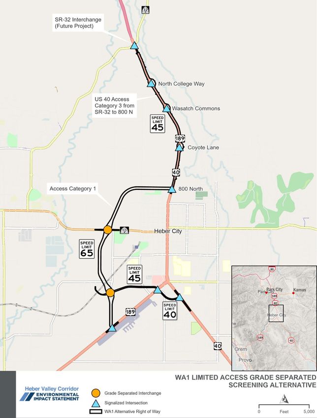
Table 3-8. Level 1 Regional Mobility Measures ....................................................................................................... 46
Table 3-9. Level 1 Regional Mobility Criteria Screening Results ............................................................................. 47
Table 3-10. Final Level 1 Screening Results ............................................................................................................ 48
Table 3-11. Level 2 Screening Criteria and Measures ............................................................................................. 54
Table 3-12. Level 2 Waters of the United States Screening Results ....................................................................... 64
Table 3-13. Level 2 Section 4(f) Screening Results ................................................................................................. 65
Table 3-14. Level 2 Right of Way and Cost Screening Results ............................................................................... 66
Table 3-15. Final Level 2 Screening Results ............................................................................................................ 67
Table 4-1. New Alternative Names for Western Bypasses That Advance to the EIS .............................................. 69

Figures
Figure 2-1. Screening Process Overview ................................................................................................................... 5
Figure 3-1. Needs Assessment Study Area ............................................................................................................. 11
Figure 3-2. Initial Alternatives for U.S. 40 Presented during Public Comment Period ............................................. 16
Figure 3-3. Initial Alternatives for East Bypass Presented during Public Comment Period ..................................... 17
Figure 3-4. Initial Alternatives for West Bypass Presented during Public Comment Period .................................... 18
Figure 3-5. Level 1 Design Layouts for U.S. 40 Improvements and Reversible Lanes ........................................... 26
Figure 3-6. Level 1 Design Cross Sections for U.S. 40 Main Street Alternatives .................................................... 27
Figure 3-7. Level 1 Design Layouts for Couplets ..................................................................................................... 28
Figure 3-8. Level 1 Design Cross Sections for One-way Couplet and Reversible-lane Alternatives ....................... 29
Figure 3-9. Level 1 Design Layouts for East Bypasses............................................................................................ 30
Figure 3-10. Level 1 Design Layouts for Limited-access West Bypasses ............................................................... 31
Figure 3-11. Level 1 Design Layouts for West Bypass Parkways ............................................................................ 32
Figure 3-12. Level 1 Design Layouts for West Bypass Arterials .............................................................................. 33
Figure 3-13. Level 1 Design Layouts for West Bypasses with Roundabouts and Southern Extension ................... 34
Figure 3-14. Level 1 Design Cross Sections for East and West Bypasses.............................................................. 35
Figure 3-15. Overhead Gantry Example from Utah .................................................................................................. 51
Figure 3-16. Level 2 Design Layout for Limited-access West Bypass (WA1) .......................................................... 56
Figure 3-17. Level 2 Design Layout for Limited-access West Bypass with Northern Extension (WA3) .................. 57
Figure 3-18. Level 2 Design Layout for West Bypass Parkway (WB1) .................................................................... 58
Figure 3-19. Level 2 Design Layout for West Bypass Parkway and Realignment of U.S. 189 (WB2) .................... 59
Figure 3-20. Level 2 Design Layout for West Bypass Parkway with Northern Extension (WB3)............................. 60
Figure 3-21. Level 2 Design Layout for West Bypass Parkway with Northern Extension and Realigned
        U.S. 189 (WB4)............................................................................................................................................ 61
Figure 3-22. Level 2 Design Cross Sections by West Bypass Alternative ............................................................... 62
Figure 3-23. Level 2 Design Cross Sections for North 40 and 1300 South ............................................................. 63

ii | June 7, 2022                                                                                                Draft Alternatives Development and Screening Report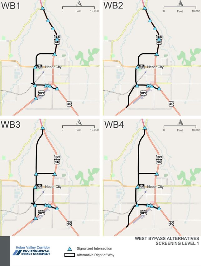
Appendixes
Appendix A.         Agency Alternatives Meeting
Appendix B.         Notifications of Alternatives Meetings and Comment Period
Appendix C.         Virtual Open House Meeting Materials
Appendix D.         In-person Open House Meeting Materials
Appendix E.         Council Presentations
Appendix F.         Stakeholder Working Group Meeting
Appendix G.         Alternatives Comments
Appendix H.         Responses to Alternatives Comments
Appendix I.         Alternatives Suggested by the Public
Appendix J.         Traffic Memorandum

Draft Alternatives Development and Screening Report                             June 7, 2022 | iii
Acronyms and Abbreviations
ac                  acres
CFR                 Code of Federal Regulations
EIS                 Environmental Impact Statement
FAQ                 frequently asked questions
FHWA                Federal Highway Administration
ft                  feet
GIS                 geographic information systems
hub                 intersection of U.S. 40 and U.S. 189 on the south side of Heber City
lf                  linear feet
LOS                 level of service
MAG                 Mountainland Association of Governments
MOU                 Memorandum of Agreement
mph                 miles per hour
NA                  not applicable
NEPA                National Environmental Policy Act
NOI                 Notice of Intent
S.R.                state route
Section 4(f)        Section 4(f) of the Department of Transportation Act of 1966
Section 404         Section 404 of the Clean Water Act
SWG                 Stakeholder Working Group
U.S.                United States
U.S. 189            U.S. Highway 189
U.S. 40             U.S. Highway 40
UDOT                Utah Department of Transportation
USACE               United States Army Corps of Engineers
USC                 United States Code
USDOT               United States Department of Transportation
WOTUS               waters of the United States

iv | June 7, 2022                                                                 Draft Alternatives Development and Screening Report
1.0              Executive Summary
This report summarizes and presents the results of the alternatives
                                                                                What is the purpose of this
development and screening process for the Environmental Impact                  report?
Statement (EIS) for the Heber Valley Corridor Project. The study area for
the transportation needs assessment used for the Heber Valley Corridor          This report summarizes and
                                                                                presents the results of the
EIS is focused on U.S. Highway 40 (U.S. 40) from its intersection with
                                                                                alternatives development and
State Route (S.R.) 32 to its junction with U.S. Highway 189 (U.S. 189) in       screening process for the EIS for
Heber City. It also includes U.S. 40 to the southeast and U.S. 189 to the       the Heber Valley Corridor
southwest.                                                                      Project.

The alternatives development and screening process described in this
report provided critical information about how well each of the project alternatives would satisfy the purpose
of the project and whether it is reasonable and practicable. The criteria used in the screening analysis
resulted in measures that allowed the Utah Department of Transportation (UDOT) to systematically and
objectively identify reasonable alternatives and screen out unreasonable alternatives. The screening criteria
are summarized in Section 3.0, Alternatives Development and Screening Process. The entire alternatives
development and screening process took place over several months and considered agency and public
input.
The environmental review, consultation, and other actions required by applicable federal environmental laws
for this project are being or have been, carried out by UDOT pursuant to 23 United States Code (USC)
Section 327 and a Memorandum of Understanding dated May 26, 2022, and executed by the Federal
Highway Administration (FHWA) and UDOT.

Draft Alternatives Development and Screening Report                                                  June 7, 2022 | 1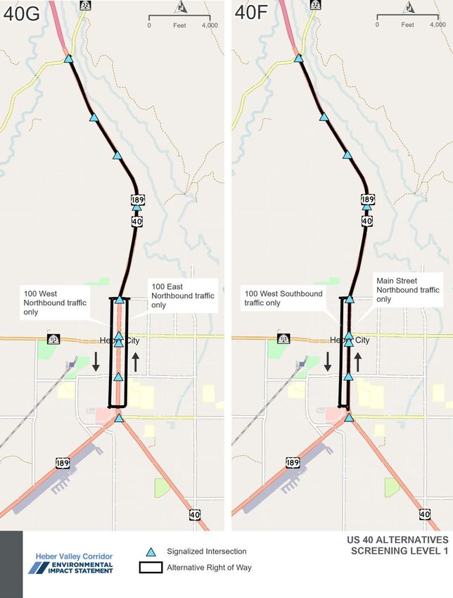
1.1                           Alternatives Considered but Not Carried Forward
UDOT developed 23 alternatives for evaluation in screening based on previous studies, public and agency
input during scoping, and local and regional land use and transportation plans. Of the 23 alternatives
reviewed, 18 did not pass screening. These 18 alternatives failed because they were not reasonable and
practicable, they did not support local or regional traffic mobility, they did not support Heber City’s vision for
its historic town center, or the impacts to key resources were too great compared to other similar
alternatives. The 18 alternatives that did not pass screening are listed in Table 1-1.

   Table 1-1. Alternatives That Did Not Pass Screening
                                                                                         Preliminary    Level 1         Level 2            Passed
   Alternative                                                                           Screening     Screening       Screening         Screening?
                        —     Transit alternative                                            Fail         NA                NA                 No
                        40A   Widen U.S. 40                                                 Pass          Fail              NA                 No
 U.S. 40 Improvements

                        40B   Improve U.S. 40 – roundabouts                                 Pass          Fail              NA                 No
                        40C   Improve U.S. 40 – intersection improvements                   Pass          Fail              NA                 No
                        40D   Improve U.S. 40 – tunneling or bridging                        Fail         NA                NA                 No
                        40E   Reversible lanes                                              Pass          Fail              NA                 No
                        40F   One-way couplet                                               Pass          Fail              NA                 No
                        40G   One-way couplet on 100 West and 100 East                      Pass          Fail              NA                 No
                        EA    East bypass – limited access and grade-separated
 East Bypasses

                              interchanges                                                  Pass          Fail              NA                 No

                        EB    East bypass – parkway and at-grade intersections              Pass          Fail              NA                 No
                        EC    East bypass – arterial route and at-grade intersections       Pass          Fail              NA                 No
                        WA2   West bypass – limited access and grade-separated
                              interchanges and realign U.S. 189                             Pass          Fail              NA                 No

                        WA3   West bypass – limited access and grade-separated
                                                                                            Pass         Pass              Fail                No
                              interchanges with northern extension
                        WC1   West bypass – arterial route and at-grade intersections       Pass          Fail              NA                 No
 West Bypasses

                        WC2   West bypass – arterial route and at-grade intersections
                              and realign U.S. 189                                          Pass          Fail              NA                 No

                        WD1   West bypass – parkway and turbo roundabouts                   Pass          Fail              NA                 No
                        WD2   West bypass – parkway and turbo roundabouts with
                              connection at 1300 South                                      Pass          Fail              NA                 No

                        WS    West bypass with southern extension – arterial route and
                              at-grade intersections                                        Pass          Fail              NA                 No

2 | June 7, 2022                                                                                        Draft Alternatives Development and Screening Report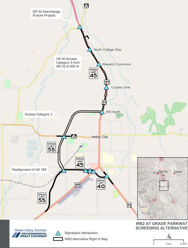
1.2 Alternatives Advanced for Further Evaluation in the
Draft EIS
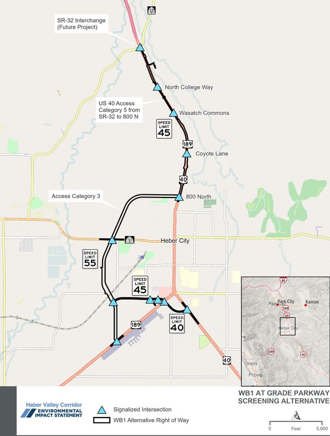
Five alternatives (WA1, WB1, WB2, WB3, and WB4) passed screening and will be studied in detail in the
Draft EIS (Table 1-2). All five alternatives that passed screening were western bypass alternatives. These
western bypass alternatives vary in their connection to U.S. 40 and U.S. 189 and vary in intersection type
and functionality of the road (grade-separated interchanges [WA1] versus signalized at-grade intersections
[WB1, WB2, WB3, and WB4]).
The alternatives that passed the screening process will be further developed to support detailed analysis in
the EIS. The engineering refinement phase will include additional design work to provide details such as
horizontal and vertical alignments, right-of-way needs, intersection design, pedestrian and bicycle
accommodations, access design, and potential drainage designs including stormwater management. Access
design will include road, driveway, or parking lot revisions for properties intersected by an alternative. All five
alternatives will be designed to a similar level of detail.
Table 1-2. Alternatives That Passed Screening and Will Be Studied in Detail
Preliminary Level 1 Level 2 Passed
Alternative Screening Screening Screening Screening?
WA1 West bypass – limited access and grade-
Pass Pass Pass Yes
separated interchanges
WB1 West bypass – parkway and at-grade
Pass Pass Pass Yes
intersections
West Bypasses
WB2 West bypass – parkway and at-grade
Pass Pass Pass Yes
intersections and realign U.S. 189
WB3 West bypass – parkway and at-grade
Pass Pass Pass Yes
intersections with northern extension
WB4 West bypass – parkway and at-grade
intersections with northern extension and Pass Pass Pass Yes
realigned U.S. 189
Draft Alternatives Development and Screening Report June 7, 2022 | 3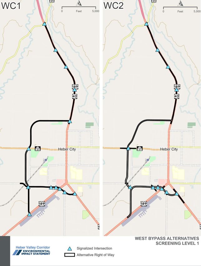
2.0                Introduction
2.1                Report Purpose and Background Information
The purpose of this report is to describe the alternatives development and
                                                                                     What is travel demand?
screening process that was used for the Heber Valley Corridor
Environmental Impact Statement (EIS). The Utah Department of                         Travel demand is the expected
Transportation (UDOT) is preparing the EIS to evaluate transportation                number of transportation trips in
solutions to improve mobility through the Heber Valley and the operation             an area. Travel demand can be
                                                                                     met by various modes of travel,
of U.S. Highway 40 (U.S. 40). Improvements are needed to address
                                                                                     such as automobile, bus,
congestion and delay and to accommodate current and projected travel                 carpooling, walking, and cycling.
demand in 2050. The process consisted of the following five basic
phases:
     1. Developing conceptual alternatives                                           What is a reasonable
                                                                                     alternative?
          a. Public and agency input was sought on conceptual
             alternatives during scoping; see Section 3.2.2, Scoping for a           Reasonable alternates include
             summary                                                                 those that are practical or
                                                                                     feasible from the technical and
     2. Conducting a preliminary evaluation of conceptual alternatives               economic standpoints and using
                                                                                     common sense.
     3. Applying first-level (Level 1) screening criteria and identifying and
        refining alternatives that pass the first-level screening                    What is a practicable
                                                                                     alternative?
     4. Refining alternatives that pass Level 1 screening for Level 2
                                                                                     Practicable means the action is
        screening
                                                                                     available and capable of being
     5. Applying second-level (Level 2) screening criteria and identifying           done after taking into
        alternatives that will be analyzed in detail in the EIS                      consideration cost, existing
                                                                                     technology, and logistics in light
The alternatives development and screening process described in this                 of overall project purposes.
report provides critical information about how well each alternative                 What is a feasible and prudent
satisfies the project’s purpose and whether it is reasonable under the               alternative?
National Environmental Policy Act (NEPA), practicable under the Clean                A feasible and prudent
Water Act, and feasible and prudent under Section 4(f) of the Department             avoidance alternative avoids
of Transportation Act of 1966. For more information regarding the                    using Section 4(f) property and
regulations considered in this screening process, see Section 2.3,                   does not cause other severe
Reasons Why an Alternative Might Be Eliminated during the Screening                  problems of a magnitude that
                                                                                     substantially outweighs the
Process.
                                                                                     importance of protecting the
The Federal Highway Administration (FHWA) has assigned its                           Section 4(f) property. An
responsibilities under NEPA and other federal environmental laws to                  alternative is not feasible if it
                                                                                     cannot be built as a matter of
UDOT for highway projects in Utah, pursuant to 23 United States Code
                                                                                     sound engineering judgment.
Section 327, in a Memorandum of Understanding (MOU) dated May 26,
2022. In accordance with its responsibilities, UDOT is carrying out the
environmental review process for the Heber Valley Corridor Project in lieu of FHWA and serves as the lead

4 | June 7, 2022                                                                Draft Alternatives Development and Screening Report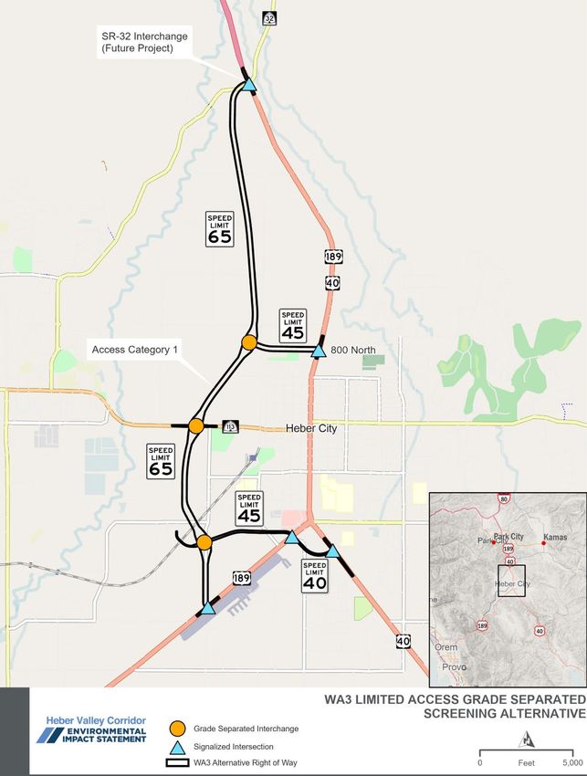
agency in the NEPA process. The assignment of NEPA responsibilities to UDOT does not change the roles
and responsibilities of any other federal agency whose review or approval is required for the project.

2.2              Screening Process Overview
UDOT conducted a three-level (Preliminary, Level 1, and          Figure 2-1. Screening Process Overview
Level 2) screening evaluation of alternatives suggested by
stakeholders and in previous studies (Figure 2-1). Agency
and public inputs (scoping) occurred during the Develop
Conceptual Alternatives phase shown in the figure.
A summary of the public and agency input received during
the formal comment period held during the scoping phase
is provided in Section 3.2.2, Scoping. The release of this
report initiates another formal request for public and
agency input.
As shown in Figure 2-1, the project’s purpose and needs
are the foundation of the alternatives screening process.
After UDOT developed the conceptual alternatives, it
began the screening process with a preliminary evaluation
of conceptual alternatives to determine whether they had
fatal flaws. Alternatives with fatal flaws—for example,
alternatives that are not technically feasible—were
determined to not be reasonable. If an alternative did not
have fatal flaws, it was further developed so that Level 1
screening could be conducted.
Level 1 screening was based on the project’s purpose. The project purpose is to substantially improve
regional and local mobility on U.S. 40 through 2050, provide opportunities for nonmotorized transportation,
and allow Heber City to meet their vision for the historic town center. The alternatives that passed Level 1
screening were determined to satisfy the project’s purpose and were then further refined and evaluated with
Level 2 screening criteria to determine their expected impacts to key resources. Alternatives that do not
satisfy the project’s purpose or that have unacceptable impacts were determined to not be reasonable.
The alternatives development and screening process is designed to be dynamic throughout the EIS process.
If a new alternative or refinement of an alternative is developed or arises later in the EIS process, it will be
considered using the same screening considerations and criteria as the other alternatives, as described in
this report.

Draft Alternatives Development and Screening Report                                                June 7, 2022 | 5
2.3                Reasons Why an Alternative Might Be Eliminated during
                   the Screening Process
This section describes the laws and guidance used to determine whether an alternative might be eliminated
during the screening process.

2.3.1              Council on Environmental Quality Regulations and Guidance
NEPA's implementing regulations define reasonable alternatives as those that meet the project’s purpose
and need and that are technically and economically feasible. According to these regulations and the Council
on Environmental Quality, there are three primary reasons why an alternative might be determined to be not
reasonable and thus eliminated from further consideration.
     1. The alternative does not satisfy the purpose of the project (this is evaluated in the Level 1 screening
        for the Heber Valley Corridor Project).
     2. The alternative is determined to be not practical or feasible from a technical and/or economic
        standpoint and using common sense (this is evaluated in the preliminary evaluation for the Heber
        Valley Corridor Project).
          a. Improve U.S. 40 – tunneling or bridging (40D) was eliminated in preliminary screening for not
             being practical.
     3. The alternative substantially duplicates another alternative; that is, it is otherwise reasonable but
        offers little or no advantage for satisfying the project’s purpose, and it has impacts and/or costs that
        are similar to or greater than those of other, similar alternatives (this is evaluated in the Level 2
        screening for the Heber Valley Corridor Project).
          a. West bypass – limited access and grade-separated interchanges with northern extension (WA3)
             was eliminated in Level 2 screening for high impacts to key resources compared to similar
             alternatives.

2.3.2              Clean Water Act Requirements
Because the area of analysis for the Heber Valley Corridor Project includes federally regulated wetlands or
other waters of the United States, UDOT considered the Clean Water Act Section 404(b)(1) Guidelines for
Specification of Disposal Sites for Dredged or Fill Material (40 Code of Federal Regulations [CFR] Part 230)
and Executive Order 11990, Protection of Wetlands, during the alternatives development phase. The U.S.
Army Corps of Engineers is responsible for determining compliance with the Section 404(b)(1) Guidelines
and may permit only the least environmentally damaging practicable alternative.

6 | June 7, 2022                                                              Draft Alternatives Development and Screening Report
The Section 404(b)(1) Guidelines state that “no discharge of dredged or fill material [to Section 404–
regulated waters] shall be permitted if there is a practicable alternative to the proposed discharge which
would have less adverse impact on the aquatic ecosystem, so long as the alternative does not have other
significant adverse environmental consequences” [40 CFR Section 230.10(a)]. This section of the
Guidelines further states that:
1. For the purpose of this requirement, practicable alternatives include but are not limited to:
i. Activities which do not involve a discharge of dredged or fill material into the waters of the
United States or ocean waters;
ii. Discharges of dredged or fill material at other locations in waters of the United States or
ocean waters[.]
2. An alternative is practicable if it is available and capable of being done after taking into
consideration cost, existing technology, and logistics in light of overall project purposes. If it is
otherwise a practicable alternative, an area not presently owned by the applicant which could
reasonably be obtained, utilized, expanded, or managed in order to fulfill the basic purpose of the
proposed activity may be considered.
3. Where the activity associated with a discharge which is proposed for a special aquatic site
(as defined in Subpart E [of the Guidelines]) does not require access or proximity to or siting within
the special aquatic site in question to fulfill its basic purpose (i.e., is not “water dependent”),
practicable alternatives that do not involve special aquatic sites are presumed to be available,
unless clearly demonstrated otherwise. In addition, where a discharge is proposed for a special
aquatic site, all practicable alternatives to the proposed discharge which do not involve a
discharge into a special aquatic site are presumed to have less adverse impact on the aquatic
ecosystem, unless clearly demonstrated otherwise.
UDOT considered the Section 404(b)(1) Guidelines during two aspects of the screening process. First,
during preliminary evaluation, UDOT determined which alternatives would be practicable. One alternative
(40D) was eliminated as not practicable because of the limitation of available technology, logistics, and high
costs. Second, during Level 2 screening, UDOT evaluated alternatives considering potential wetland
impacts and also refined alternative alignments to try to avoid and minimize impacts to wetlands and other
waters. One alternative was eliminated during Level 2 screening because it would have more-severe
impacts to waters of the United States than other alternatives and offered little to no operational advantages
compared to other alternatives that would have fewer wetland impacts. To achieve final compliance with the
Section 404(b)(1) Guidelines, UDOT will need to demonstrate, through an evaluation of alternatives
considered during screening and those evaluated in detail in the EIS, that the alternative selected in the
project’s Record of Decision is the least environmentally damaging practicable alternative.
Draft Alternatives Development and Screening Report June 7, 2022 | 72.3.3 Section 4(f) Requirements
Section 4(f) of the Department of Transportation Act of 1966 (49 USC Section 303) applies to publicly owned
parks, recreation areas, and wildlife and waterfowl refuges and publicly or privately owned significant historic
properties. The requirements of Section 4(f) apply only to agencies within the U.S. Department of
Transportation (USDOT)—for example, FHWA. Pursuant to 23 USC Section 327 and the NEPA Assignment
Memorandum of Understanding between FHWA and UDOT dated May 26, 2022, UDOT is responsible for
meeting Section 4(f) requirements for FHWA.
Section 4(f) prohibits USDOT agencies (and in this case UDOT) from approving the use of any Section 4(f)
land for a transportation project except as follows:
• First, the USDOT agency can approve the use of a Section 4(f) property only if it makes a
determination that (1) there is no prudent and feasible alternative that would avoid the use of the
Section 4(f) property and (2) the project includes all possible planning to minimize harm to that
property; or
• Second, if there is no feasible and prudent avoidance alternative
What is a de minimis impact?
and all remaining alternatives have Section 4(f) uses, the
approved alternative would cause least overall harm in light of For publicly owned public parks,
Section 4(f)'s preservation purpose; or recreation areas, and wildlife and
waterfowl refuges, a de minimis
• Third, the USDOT agency can approve the use of Section 4(f) impact is one that would not
property by making a de minimis impact determination for the use adversely affect the activities,
of that property. features, or attributes of the
property.
UDOT considered the Section 4(f) requirements during two aspects of the For historic sites, a finding of
screening process. First, during preliminary evaluation, UDOT determined de minimis impact means FHWA
that some concepts (for example, building a tunnel under Main Street) has determined that the project
would not be prudent and/or feasible. Second, during Level 2 screening, would have “no adverse effect”
on the historic property.
UDOT evaluated alternatives considering potential use of Section 4(f)
properties and refined alternative alignments to try to avoid and minimize
impacts to those properties. No alternatives were eliminated during Level 2 screening because of the
severity of Section 4(f) uses that would be required. To achieve compliance with the Section 4(f) regulations,
UDOT will need to demonstrate through an evaluation of alternatives remaining after screening that either
(1) the alternative selected would have a de minimis use of Section 4(f) resources or (2) there is no feasible
and prudent alternative that would avoid the use of Section 4(f) resources, and the project alternative
selected demonstrates the least overall harm and includes all possible planning to minimize harm to
Section 4(f) resources.
8 | June 7, 2022 Draft Alternatives Development and Screening Report2.4 Summary of the Project’s Purpose and Need
The primary criterion for determining whether an alternative is reasonable, feasible and prudent, and
practicable is whether it meets the purpose of and needs for the project. For the Heber Valley Corridor
Project, UDOT’s purpose is to improve both regional and local mobility on U.S. 40 from State Route
(S.R.) 32 to U.S. 189 and provide opportunities for nonmotorized transportation while allowing Heber City to
meet their vision for the historic town center.
The evaluation of transportation needs in the Heber Valley is focused on
What is the PM peak hour?
U.S. 40 because it is the only principal arterial in the valley that conveys
regional traffic through the length of the valley. U.S. 40 presents The PM peak hour is the 1-hour
challenges for local and regional mobility today and in the future. The period afternoon (PM) during
transportation needs are related primarily to traffic during peak periods, which there is the greatest
number of vehicles on the road
which is forecasted to get worse with increasing population and economic
system.
activity. The following deficiencies have been identified in the study area:
• The character and function of U.S. 40 change from a 65-miles-
per-hour (mph), limited-access freeway north of town to a 35-mph Main Street in Heber City with
signalized intersections. Vehicle throughput (the number of vehicles per day) on U.S. 40 is traded for
increased access within Heber’s historic core, resulting in congestion and delay.
• U.S. 40 is currently operating at failing conditions (level of service F) from 100 North to 100 South
during the PM peak hour, and these conditions will continue to get worse through 2050.
• Signalized intersections on U.S. 40 are currently operating at acceptable conditions, but many are
expected to operate at failing conditions during the PM peak hour by 2050 if no improvements are
made.
• Southbound travel time on U.S. 40 from S.R. 32 to U.S. 189 during the PM peak hour will double by
2050 if no improvements are made.
• Queue lengths (vehicles backed up waiting to get through an intersection) during the PM peak hour
will increase and spill back to other intersections and onto U.S. 40 north of town where the posted
speed is 55 mph, resulting in safety concerns.
• There is limited designated infrastructure and lack of connectivity with existing infrastructure for
nonmotorized transportation in the Heber Valley. This lack of accommodations creates a low-comfort
experience for all but the most confident pedestrians and bicyclists.
In addition, Heber City’s general plan, Heber City Envision 2050 (Heber City 2020), identifies the following
deficiencies:
• Increased traffic on Main Street has disrupted the traditional feel with increased noise and
pedestrian safety concerns.
See the Purpose and Need Technical Report (UDOT 2021) for more information regarding the project
purpose and need (available on the project website at hebervalleyeis.udot.utah.gov).
UDOT developed criteria to measure each alternative’s ability to satisfy the project’s purpose. If an
alternative would not satisfy the project’s purpose, it is proposed to be eliminated from further consideration.
See Section 3.3.2, Level 1 Screening, for a description of the purpose criteria used in Level 1 screening.
Draft Alternatives Development and Screening Report June 7, 2022 | 93.0 Alternatives Development and Screening
Process
3.1 Definition of Study Area Phase
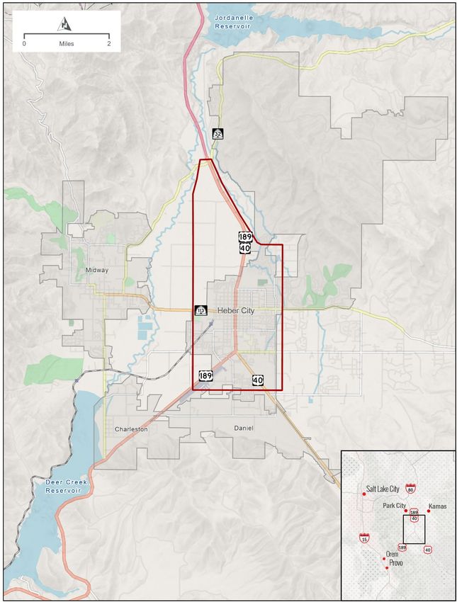
The first step was to define the project’s study area. UDOT defined the study area as the area that
encompasses the problems identified in the purpose and need statement and within which a proposed
alternative would be expected to meet the project’s purpose. Travel demand modeling was used to
determine the effectiveness of proposed alternatives on U.S. 40 and the geographic extent of effective
alternative alignments. That is, it was also used to determine how far away an alternative could be from
U.S. 40 and still meet the project’s purpose to relieve local and regional travel demand.
Traffic modeling found that if a proposed alternative is too far from
What types of traffic are
U.S. 40, it would not benefit regional and local mobility because it would
present on Main Street?
not draw enough traffic off U.S. 40 (drivers would avoid out-of-direction
travel and excessive travel times). To reduce congestion on U.S. 40, an Local traffic is traffic that starts
alternative needs to be within about 1 mile east or west of the U.S. 40 and ends within the Heber
Valley. This traffic type was 50%
mainline. Based on modeling results, UDOT also determined that this
of the traffic on Main Street in
location is important for moving local traffic, which is the dominant traffic 2019.
type using U.S. 40 (about 50% of traffic on Main Street in 2019 is local
Regional traffic is traffic that
traffic). starts or ends in the Heber
Regional traffic and through-traffic are 20% and 30%, respectively, of the Valley, typically long-distance
commuters or visitors. This traffic
traffic on Main Street; however, both types of traffic are sensitive to out-of-
type was 20% of traffic in 2019.
direction travel. Modeling determined that drivers would continue to use
Through-traffic is traffic that
U.S. 40 if an alternative route is too far away. To reduce freight traffic on
travels through the Heber Valley,
the Main Street segment of U.S. 40 (a project purpose to meet originating and ending at
Heber City’s Vision), an alternative must also be located nearby and locations outside the valley. This
provide convenient connections to U.S. 40 and U.S. 189 to serve freight traffic type was 30% of traffic in
traffic. Figure 3-1 shows the study area in which alternatives would benefit 2019.
both local and regional traffic (as determined by travel demand modeling).
3.2 Development of Preliminary Alternatives
The next phase in the alternatives development and screening process was identifying a list of preliminary
alternatives. To be considered a preliminary alternative, an alternative had to be applicable to the study area
defined above and had to present a type of solution that could meet the project’s purpose and identified
transportation needs.
UDOT developed the preliminary alternatives based on previous planning studies and through the EIS
scoping and outreach processes. The preliminary alternatives were developed with input from existing
transportation plans, the public, local municipal governments, and resource agencies. The input was
collected during the EIS public scoping periods (an early scoping period from August 26 to October 3, 2020,
and a formal scoping period from April 30 to June 14, 2021) and in stakeholder interviews.
10 | June 7, 2022 Draft Alternatives Development and Screening ReportFigure 3-1. Needs Assessment Study Area Draft Alternatives Development and Screening Report June 7, 2022 | 11
3.2.1          Previous Studies and Plans
UDOT identified potential alternatives from the following previous transportation plans and studies:
     •    Heber City Downtown Study (Downtown Redevelopment Services, no date)
     •    Heber City Envision 2050 (Heber City 2020)
     •    Transportation Plan 2017 (Heber City 2017)
     •    Wasatch County General Plan 2001–2016 (Wasatch County 2010)
     •    Heber City Highway Bypass Study (PEC, no date)
     •    Heber Valley Parkway Planning Study, conducted for UDOT, Mountainland Association of
          Governments (MAG), Heber City, and Wasatch County (Avenue Consultants 2019)
     •    2019–2050 Wasatch Regional Transportation Plan (MAG 2019)
     •    2019–2050 Statewide Rural Long-range Transportation Plan (UDOT 2019a)

3.2.2          Scoping
NEPA scoping is a formal EIS outreach and coordination process to                What is scoping?
determine the scope of issues to be addressed and to identify significant
                                                                                 NEPA scoping is a formal EIS
issues related to the proposed action. UDOT used the scoping process to          outreach and coordination
identify and review the purpose of and need for the project and                  process to determine the scope
alternatives to consider in the EIS. UDOT used several methods to                of issues to be addressed and to
involve agencies and the public during the development of alternatives,          identify significant issues related
including meetings, open houses, a project website, and newsletters to           to the proposed action. UDOT
                                                                                 conducted an early scoping
advertise and allow reviews of project materials.
                                                                                 process in 2020, prior to initiating
                                                                                 the EIS. Another formal scoping
Early Scoping                                                                    process was conducted when
                                                                                 UDOT published the notice of
UDOT conducted an early scoping process to solicit public and agency             intent to prepare an EIS in May
input to develop the project purpose and need statement, identify a              2021.
preliminary range of alternatives, and identify potentially significant
environmental issues. The Early Scoping Summary Report summarizes
public and agency input and identifies the alternatives that were suggested during the early scoping process
from August 26 to October 3, 2020.

12 | June 7, 2022                                                           Draft Alternatives Development and Screening Report
Scoping and Notice of Intent
The Scoping Summary Report summarizes public and agency input gathered during the formal scoping
period, which lasted 45 days from April 30 to June 14, 2021. The Notice of Intent (NOI) was published during
the formal scoping period on May 11, 2021. The NOI and formal scoping presented the following preliminary
alternatives for comment:
• No action
• Improvements to U.S. 40 such as adding lanes and intersection improvements
• Improvements to existing roads other than U.S. 40
• A one-way-couplet system
• A new bypass west of U.S. 40
• A new bypass east of U.S. 40
• Transportation System Management (TSM)
• Transit
As discussed in the Scoping Summary Report, during the EIS scoping processes in 2020 and 2021, UDOT
received close to 400 comments, and some comments suggested additional concepts and potential
alternatives for UDOT to consider in the EIS. These comments addressed alternative locations, alternative
configurations, travel modes, safety, construction costs, construction methods, and logical termini (the
logical endpoints for the improvements to U.S. 40). Where applicable, UDOT incorporated the scoping
comments to develop and refine a range of preliminary alternatives. The additional concepts for alternatives
suggested during scoping included the following:
• Improvements on U.S. 40, including:
o Intersection improvements such as wider intersections and roundabouts
o Tunnel under U.S. 40 within the Heber City limits
o Bridge over U.S. 40 within the Heber City limits
• New locations for a new bypass west of U.S. 40
• New locations for a new bypass east of U.S. 40
Initial Alternative Concepts
From the basic concepts identified during scoping, UDOT developed the ideas into 17 distinct alternative
concepts and published them for public review and input. These 17 alternative concepts are described in
Table 3-1 and shown in Figure 3-2 through Figure 3-4. To allow objective screening, all of the proposed
alternative concepts were developed to an equal level of detail. UDOT solicited input on the 17 initial
alternative concepts at meetings and during the public comment period, which ran from October 5 to
November 4, 2021. See Appendix B, Notifications of Alternatives Meetings and Comment Period, for the
notifications for the public meeting, and Appendix C, Virtual Open House Meeting Materials, and
Appendix D, In-person Open House Meeting Materials, for the supporting materials displayed at the public
meetings that describe the 17 alternative concepts.
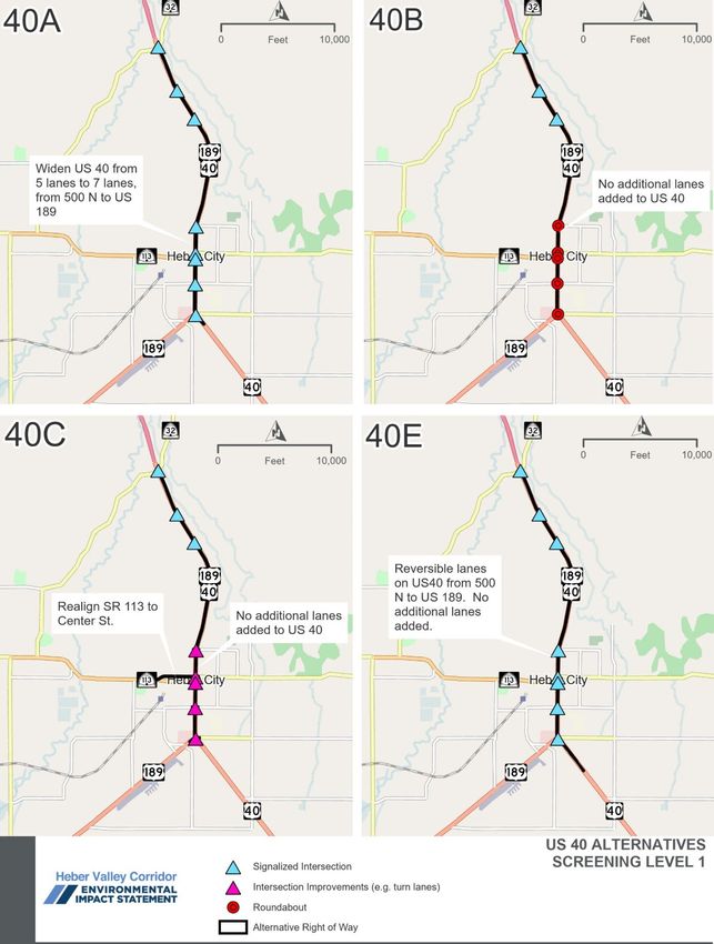
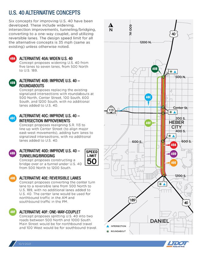
Draft Alternatives Development and Screening Report June 7, 2022 | 13Table 3-1. Initial Alternative Concepts Presented during the Public Comment Period
Alternative Description
— Transit alternative The Wasatch County Transit Study (MAG 2020) identified a combination of local services
in the Heber Valley connecting Heber City, Midway, and Charleston; a Park City
commuter route from Heber City; a Wasatch County to Utah County commuter route from
Heber City to the Vineyard FrontRunner Station in Orem; and vanpool services from
Heber City to Orem and Park City, starting with dial-a-ride service in Midway and
Heber City.
Improvements on U.S. 40 (Figure 3-2)
40A Widen U.S. 40 Concept proposes widening U.S. 40 from five lanes to seven lanes from 500 North to
U.S. 189.
40B Improve U.S. 40 – roundabouts Concept proposes replacing the existing signalized intersections with roundabouts at
500 North, Center Street, 100 South, 600 South, and 1200 South, with no additional lanes
added to U.S. 40.
40C Improve U.S. 40 – intersection Concept proposes realigning S.R. 113 to line up with Center Street (to align major east-
improvements west movements) and adding turn lanes to signalized intersections, with no additional
lanes added to U.S. 40. The traffic signal for 100 South would be removed with this
concept.
40D Improve U.S. 40 – tunneling or Concept proposes constructing a bridge over or a tunnel under U.S. 40 from 500 North to
bridging 1200 South.
40E Reversible lanes Concept proposes converting the center turn lane to a reversible lane from 500 North to
U.S. 189, with no additional lanes added to U.S. 40. The center lane would be used for
northbound traffic during the morning and southbound traffic during the afternoon.
40F One-way couplet Concept proposes splitting U.S. 40 into two roads between 500 North and 1000 South.
Main Street would be for northbound travel, and 100 West would be for southbound
travel.
East Bypasses (Figure 3-3)
EA East bypass – limited access and Concept proposes a highway-type facility offset from 1200 East (Mill Road) with three
grade-separated interchanges interchanges: Center Street and the north and south connections to U.S. 40. Speed limit
would be 65 mph.
EB East bypass – parkway and at Concept proposes a parkway-type facility offset from 1200 East (Mill Road) with seven
grade intersections intersections at key locations. Speed limit would be 55 mph.
EC East bypass – arterial route and Concept proposes an arterial-type facility on 1200 East (Mill Road) with intersections at all
at grade intersections cross streets (12 total). Speed limit would be 45 mph.
West Bypasses (Figure 3-4)
WA1 West bypass – limited access and Concept proposes a highway-type facility with six interchanges at major connections:
grade-separated interchanges U.S. 40 (2), U.S. 189 (2), S.R. 113, and 1300 South. Speed limit would be 65 miles per
hour (mph).
WA2 West bypass – limited access and Concept proposes a highway-type facility with six interchanges at major connections:
grade-separated interchanges U.S. 40 (2), U.S. 189 (2), S.R. 113, and 1300 South. Speed limit would be 65 mph.
and realign U.S. 189 Concept includes the realignment of U.S. 189.
WB1 West bypass – parkway and Concept proposes a parkway-type facility with eight intersections: U.S. 40 (2), U.S. 189
at-grade intersections (2), S.R. 113, 1300 South, Industrial Parkway, and 300 West. Speed limit would be
55 mph.
(continued on next page)
14 | June 7, 2022 Draft Alternatives Development and Screening ReportTable 3-1. Initial Alternative Concepts Presented during the Public Comment Period
Alternative Description
West Bypass (Figure 3-4) (continued)
WB2 West bypass – parkway and Concept proposes a parkway-type facility with eight intersections: U.S. 40 (2), U.S. 189
at-grade intersections and realign (2), S.R. 113, 1300 South, Industrial Parkway, and 300 West. Speed limit would be
U.S. 189 55 mph. Concept includes the realignment of U.S. 189.
WC1 West bypass – arterial route and Concept proposes an arterial-type facility with intersections at all cross streets (nine total):
at-grade intersections U.S. 40 (2), U.S. 189 (2), 1300 South, S.R. 113, Industrial Parkway, 300 West, and
S. Daniels Road. Speed limit would be 45 mph.
WC2 West bypass – arterial route and Concept proposes an arterial-type facility with intersections at all cross streets (nine total):
at-grade intersections and realign U.S. 40 (2), U.S. 189 (2), 1300 South, S.R. 113, Industrial Parkway, 300 West, and S.
U.S. 189 Daniels Road. Speed limit would be 45 mph. Concept includes the realignment of
U.S. 189.
WD1 West bypass – parkway and turbo Concept has turbo roundabouts at seven key locations. Speed limit would be 55 mph.
roundabouts
Draft Alternatives Development and Screening Report June 7, 2022 | 15Figure 3-2. Initial Alternatives for U.S. 40 Presented during Public Comment Period 16 | June 7, 2022 Draft Alternatives Development and Screening Report
Figure 3-3. Initial Alternatives for East Bypass Presented during Public Comment Period

Draft Alternatives Development and Screening Report                                          June 7, 2022 | 17
Figure 3-4. Initial Alternatives for West Bypass Presented during Public Comment Period

18 | June 7, 2022                                                       Draft Alternatives Development and Screening Report
3.2.3            Initial Alternatives Agency and Public Comment Period
On September 30, 2021, UDOT held an alternatives meeting to present the conceptual alternatives to
resource agencies. Representatives from the U.S. Environmental Protection Agency, U.S. Army Corps of
Engineers, U.S. Bureau of Reclamation, Utah Reclamation, Mitigation, and Conservation Commission, and
Utah Division of Wildlife Resources were in attendance. See Appendix A, Agency Alternatives Meeting, for
the presentation and meeting summary.
UDOT held two public meetings to present the conceptual alternatives for public review and comment.
A virtual public meeting was held on October 5, 2021, on Zoom, and the presentation was followed by a
question-and-answer session. An in-person open house was held on October 6 at the Heber Valley
Elementary School, and an opportunity to review materials and speak directly with UDOT was provided. The
same information was presented at both meetings. The materials presented are available in Appendix C,
Virtual Open House Meeting Minutes, and Appendix D, In-person Open House Meeting Materials. A 30-day
public comment period ran from October 5 to November 4, 2021.

Notification
The following methods were used to notify the general public of the October public meetings, the materials
available for review, and how to comment:
     •     Advertisements were placed in the following publications:
           o     Wasatch Wave, September 22 and 29, 2021
           o     The Salt Lake Tribune, September 19, 2021
           o     Deseret News, September 17, 24, and October 1, 2021
     •     Notifications and reminders were posted on the Heber Valley Corridor Project website:
           hebervalleyeis.udot.utah.gov.
     •     Notifications and reminders were posted on UDOT’s social media sites:
           o     Facebook on September 16 and 24; October 1, 5, 6, 8, 13, 18, 19, 21, and 29; and
                 November 1 and 4, 2021
           o     Instagram on October 2 and 6, 2021
           o     Paid video advertisements on Instagram intermittently from October 5 to November 4, 2021
           o     Twitter on September 16; October 1, 5, 6, 13, 18, 19, 21, 25, and 29; and November 1 and 4, 2021
     •     An email notice was sent to the Heber Valley Corridor Project mailing list on September 14 and 24;
           October 1, 5, 6, 8, 15, and 29; and November 3 and 4, 2021.
     •     Printed flyers were hung at the following locations:
           o     Dairy Keen                            o   Sinclair
           o     Heber City offices                    o   Smith's grocery store
           o     Heber City Police Department          o   Wasatch County Administrative Building
           o     Natural Grocers                       o   Wasatch County Library
     •     A UDOT press release was sent to local media outlets on September 27, 2021.
Copies of the notification materials listed above are included in Appendix B, Notifications of Alternatives
Meetings and Comment Period.

Draft Alternatives Development and Screening Report                                                 June 7, 2022 | 19
City and County Council Presentations Prior to the alternatives public comment period, UDOT presented at two city council meetings, one county council meeting, and one interlocal government meeting. UDOT presented to the Midway City Council on September 7, 2021; the Wasatch County Council on September 8, 2021; the Heber City Council on September 21, 2021; and the Wasatch County Interlocal Meeting on September 22, 2021. The presentations for the council meetings were the same and included an overview of the project’s purpose and need, a list of the alternatives under consideration, information about the upcoming public meetings, an overview of the process, and how to comment. UDOT encouraged councils and the public to submit comments on alternatives and alternatives screening criteria. A copy of the presentations is included in Appendix E, Council Presentations. Stakeholder Working Group Meetings UDOT developed a stakeholder working group (SWG) that includes 18 representatives who represent trucking, agriculture, open lands, emergency services, schools, residents, developers, local government staff, and businesses. The group serves as a communication conduit to the community and helps inform UDOT’s decision-making process. The fourth SWG meeting was held during the initial alternatives comment period on October 28, 2021, at the Heber City Police Department (with a virtual option via Zoom). Nine SWG members and eight project team members attended. A presentation was given, including an update on the revised purpose and need statement, an overview of the screening process, an overview of the alternative concepts under consideration, a summary of comments received to date, and information regarding how to comment. After the presentation, SWG members asked questions and provided comments. The presentation and notes from the meeting are included in Appendix F, Stakeholder Working Group Meeting. The SWG will continue to meet at major milestones throughout the EIS process. 3.2.4 Summary of Public Comment on Initial Alternatives The initial alternatives public comment period for the Heber Valley Corridor EIS began on October 5 and concluded on November 4, 2021. All comments that were received during this period are included in Appendix G, Alternatives Comments. UDOT reviewed each comment and assigned it a number. Appendix G includes a list of commenters presented chronologically according to the order in which they commented and the corresponding comment number. A single comment might include several issues. A summary of the comments is included below, and more details are provided in Appendix G. UDOT reviewed comments received after the formal alternatives comment period and before the development of the Draft EIS and will consider them during the development of the Draft EIS. All comments received will be considered. The public will continue to have opportunities to provide input throughout the Heber Valley Corridor EIS environmental review process, and public comments will continue to be solicited throughout the project. 20 | June 7, 2022 Draft Alternatives Development and Screening Report
During the alternatives public comment period, UDOT received about 670 individual comment submissions
from the public and agencies. Common themes included the following:
     •     An east bypass has never been part of the plan; a west bypass has been planned.
     •     An east bypass would reduce the quality of life in existing neighborhoods.
     •     An east bypass would reduce safety for students at four schools in the Mill Road area.
     •     A bypass should be placed where it would affect the fewest people.
     •     The west side is much less developed (fewer homes and schools).
     •     Something needs to be done about congestion.
     •     Congestion on Main Street is preferable to affecting so many homes and neighborhoods.
     •     The north fields and south fields should be preserved. Please don’t impact the fields.
     •     A west bypass would impact natural resources (wetlands, creeks, aquifer, and/or wildlife).
     •     A bypass should connect to U.S. 40 farther to the north (River Road/S.R. 32) for a long-term
           solution. Development will continue to the north.

Suggestions for new alternatives or modifications to existing alternatives included the following:
     •     New alignments for bypass and one-way-couplet alternatives
     •     Different locations for bypass alternatives to connect to U.S. 40 and/or U.S. 189
     •     Different locations for and types of connections to the local road network for bypass alternatives
           (that is, specific type of interchange or intersections at specific locations)
     •     Regulating truck traffic
     •     Constructing a frontage road or median barrier on U.S. 40 (north of Heber City)
     •     Widening U.S. 40 and U.S. 189 south of Heber City, or installing a median barrier
     •     Spot improvements (for example, new traffic signals and pedestrian crossings)
     •     Lowering the speed limit or implementing traffic-calming measures on Main Street
     •     Combining different alternatives
     •     Building an oil pipeline or a railway to haul crude oil (to eliminate oil tanker truck traffic)

UDOT sorted the comments suggesting new or modified alternatives and split or combined them into about
40 unique suggestions. UDOT reviewed each suggestion for new alternatives or modifications to existing
alternatives to determine if they should be evaluated further in the screening process. The reasons not to
carry suggestions through the screening process included the following:
     •     Included in No-action Alternative
     •     Does not meet project objectives
     •     Outside the study area
     •     Outside the scope of the EIS
     •     Not technically feasible
     •     Will be considered during alternatives development (the comment suggested a design detail that
           could be incorporated into an alternative but did not suggest a standalone alternative)

Draft Alternatives Development and Screening Report                                                          June 7, 2022 | 21
You can also read