Draft Report of GEO XVI - Group on Earth Observations
←
→
Page content transcription
If your browser does not render page correctly, please read the page content below
XVII GEO Plenary – 4-5 November 2020                                      GEO-XVII-xx.x

                            Draft Report of GEO XVI
                    This Document is submitted to Plenary for decision.

 Wednesday, 6 November 2019
 Meeting convened at 09:00 am
 OPENING SESSION
 Chair: Mr. Pengde Li, Deputy Director General, China Geological Survey, Ministry of
 Natural Resources, People’s Republic of China.

 1.1   Welcome from Australia
 Mr Stuart Minchin, Chief, Environmental Geoscience Division, Geoscience Australia,
 warmly welcomed all delegates to Canberra, and prefaced his remarks by paying respect
 to traditional peoples of the Canberra Region. He noted that communities had met in
 region for thousands of years, exchanging insights, and thus it was appropriate for GEO
 to be hosting its Plenary and Ministerial in Canberra. He extended a welcome to the local
 chief and descendants of the indigenous Namur people in their native language. He then
 went on to express that Australia was proud to host this major event with over 1,400
 registered delegates taking part in various activities of GEO Week 2019. He emphasized
 that the focus this year was on Earth observations (EO) investments in Digital economy,
 which was intended to show that investments are just that: they provide return to
 governments, businesses and individuals through forming an important part of
 economic activity. Additionally, discussions were set to highlight tangible actions
 towards achieving sustainable development with EO, and several new events would be
 introduced throughout the week, such as the Pacific Island Programme designed to
 enable GEO to engage with this group of nations for the first time. Other events held in
 parallel with GEO Week 2019 included co-hosting with the UN Environment Programme
 (UNEP) the Working Group on Big Data and Digital Ecosystems for the Planet, as well as
 the Regional Committee of UN Global Geospatial Information Management for Asia and
 the Pacific (UN-GGIM-AP). The Industry Track running in parallel with the GEO Plenary
 was another innovation, providing an opportunity for the private sector to network with
 GEO Members and Participating Organizations. He noted that the Exhibition area would
 be open to public with school children be especially encouraged to come and visit,
 stimulating the next generation to think of careers in the fields of EO applications and
 geospatial information. He concluded by explaining that the GEO Plenary Week 2019
 “Earth Dreaming” logo was designed by local artist Dion Devow and that the meaning of
 the various components were as follows: the white dots within the central blue region
 were islands in the sea surrounding Australia; the multi-coloured dots surround the blue
 region represented the different peoples of Australia; the dots aligned between the open
 hands illustrates that the Earth and its inhabitants are all connected, with the hands
 symbolizing that we are guardians of the planet and its resources.
XVII GEO Plenary – 4-5 November 2020 GEO-XVII-xx.x
1.2 Opening Remarks
Plenary Chair Pengde Li representing Dr. Wei Huang, the Lead Executive Committee
Co-Chair, China, thanked Mr Minchin and expressed his sincere appreciation to
Australia for the thoughtful arrangements made in preparation for GEO Week 2019. He
also wished to thank to Co-Chair Mr. Mmboneni Muofhe, South Africa, for his hard work
as Lead Co-Chair over the past year, and also welcomed to Mr Jim Reilly as new Co-chair
for the United Sates. Mr Li also expressed his heartfelt thanks to GEO Members and
Participating Organizations for their long-term efforts and contributions to the
development of GEO and the progress of Earth observations. He welcomed in particular
the businesses and sub-national organizations that had joined GEO as Associates this
year, making GEO a more inclusive and more energetic community.
Mr Li remarked that GEO had achieved much in implementing its Strategic Plan since
the last Ministerial Summit in Mexico City, and would make even greater efforts to
deliver on the Work Programme for 2020-2022. He added that the development of
national Earth observation systems had made steady progress and the role of regional
Earth observations systems had become more prominent. These efforts have laid a solid
foundation for the implementation of GEOSS. With the concerted efforts of all
stakeholders, GEO was firmly committed to the three engagement priorities, becoming
more focused on global agendas and challenges and producing more practical results in
response to local needs. Further, he noted that Earth observations are undergoing a
significant evolution through constant integration with new digital technologies. With
the support of such technologies, Earth observations are making continuous advances,
Earth observations instruments becomes more practical and easy to use, and related
industries are thriving with greater social and economic benefits.
Mr Li commented that the GEO Week 2019 included a series of wonderful activities,
focusing on key topics of GEO and main concerns from all stakeholders. In particular, he
noted that fruitful results had been achieved at the 12th AOGEO Symposium held just
prior to GEO Week 2019 with over 200 participants from 35 countries, including
Mongolia, Myanmar, Nepal, Philippines, Sri Lanka, Thailand and Vietnam convening in
Canberra. Collaboration across the region was set to accelerate this year as AOGEO
launched three Integrated Priority Studies in Mekong River Basin, Pacific Island States
and Himalayan Mountains, to co-design and co-produce solutions with end users. For
the studies, new data, both in-situ and satellite, were being made openly available by
China, Japan and the Republic of Korea.
Mr Li also highlighted that the Industry Track activities and events being held during
GEO Week 2019 represented a unique opportunity for GEO delegates to interact with the
private sector. The Ministerial Summit at the end of the week would highlight
achievements of GEO in recent years and be presented to Ministers from the
perspectives of policy, science, business and other stakeholders. Ministers would be then
welcomed to provide guidance and make commitments for the future development of
GEO.
Mr Li concluded his remarks by emphasizing that GEO is a community in which
Members and Participating Organizations gather together to provide public services of
Earth observations for the shared aim of promoting sustainable economic and social
development and building a community with a shared future for mankind. China will, as
2 / 54XVII GEO Plenary – 4-5 November 2020 GEO-XVII-xx.x
always, devote its efforts to building a better and more capable Global Earth Observation
System of Systems (GEOSS). It was his hope that that all stakeholders would work
closely together to grasp the opportunities and address challenges brought by the digital
economy to create an even brighter future for GEO.
Co-Chair Patrick Child, Deputy Director-General, Research and Innovation, European
Commission (EC), welcomed all delegates to GEO-XVI Plenary and thanked Australia for
hosting GEO Week 2019 along with the marvellous organization preceding the event. He
commented that the week represented a milestone in the life of GEO, and thanked the
Secretariat Director, Gilberto Camara and the GEO Secretariat for their support. He also
thanked the members of the Executive Committee and the Co-Chairs for fostering a
spirit of collegiality that was inspirational. In particular, he thanked the lead Co-Chair
from South Africa, Mr Mmboneni Muofhe, for his calm but progress-oriented leadership
through the year. Mr Child was pleased to see that feedback from the GEO-XV Plenary
the previous year in Kyoto had been taken on board, evidenced by the current Plenary
agenda which made space for substantive discussion around the three GEO priority
engagement areas. In particular, he was glad that a session on climate issue had been
included to help GEO make progress on with key actors in area of climate change, such
as the UN Framework Convention on Climate Change (UNFCCC) and the
Intergovernmental Panel on Climate Change (IPCC). He emphasized the importance of
devoting time to discussing how to make GEO more results oriented, having a focus on
what GEO can actually do to produce outputs that will make GEO more relevant to the
broader community. Other innovations for GEO Week 2019, such as Australia’s vision to
host the industry track were seen as positive, presenting an opportunity to make
progress in dealing with Earth observation challenges across region.
Mr Child next presented three key messages, which were:
1) New setting in the European Commission as of 1st December.
The new president of the Commission, Ursula von der Leyen, has presented her priorities,
three of which were relevant for the Plenary meeting, including: a European Green Deal,
a Europe fit for the digital age, and a stronger Europe in the world.
Under the “European green deal” a strong emphasis will be put on preserving
Europe’s natural environment which is very relevant to many societal benefit
areas of GEO;
The priority “a Europe fit for the digital age” is very compatible with the
objectives of the theme of the GEO week on the way Earth Observation can
contribute to the digital economy;
Regarding the “Role of Europe in the world”, GEO is definitively an ideal
platform to network and connect with international partners. So, the
overarching priorities of the new Commission provide opportunities for GEO
in Europe.
He explained that the way the Commission will be organised is also quite promising in
view of future actions of the Earth Observation community. The portfolio of the
Commissioner in charge of Internal market will include two important topics: the digital
economy & space with the Copernicus programme. The portfolio of the Commissioner in
charge of innovation and youth will include Horizon Europe the future EU Research &
3 / 54XVII GEO Plenary – 4-5 November 2020 GEO-XVII-xx.x
Innovation Framework Programme which will support the European GEO contribution.
He also informed Plenary that, as the new Commission had only recently been put into
place, it was unfortunately not possible to secure the participation of the Commissioner
in this Ministerial Week. However, the GEO community should be reassured that the EC
will continue supporting GEO under its new arrangement
2) Welcome content of the Plenary agenda concentrating on GEO priorities
Mr Child remarked that, after the successful organization of the Kyoto Plenary which
included discussion with key stakeholders in the three GEO priority areas, it was very
encouraging to see this effort continued on the occasion of this Plenary. It was the hope
of the EC that the discussion in the climate session would enable progress towards
linking GEO better with key actors in the climate domain. Indeed, there is a need to
make the role of GEO more official as a unique international actor in the domain of
Earth Observation, that can provide information and data for the Climate community.
He noted that the EC was looking forward to see the proof of concept of the GEO
Knowledge Hub (GKH) that would be presented under point 6 of the agenda by the GEO
Secretariat Director. The EC believed that GEO needed build on this demonstration to
evolve GEOSS towards a result-oriented initiative. The Commission is prepared to
support such an evolution through a concrete and financeable implementation plan
3) Highlights on 2019 progress by Commission together with European Partners in
implementing GEO and future steps included:
The Copernicus programme is a major contributor in Europe to the GEOSS. Its
popularity among users worldwide is increasing significantly. Important
improvements on easy and fast data access were implemented in 2019. Five
Copernicus data information and access system platforms (DIAS) are now fully
operational and accessible for users;
One example of 2019 Copernicus achievement is through the exploitation of
the Sentinel-5P satellite mission that comes now to maturity and is the first
Copernicus satellite dedicated to monitoring our atmosphere. Very accurate
maps are now produced on a regular basis from this mission showing a range of
trace gases that affect air quality such as carbon monoxide, nitrogen dioxide
and ozone;
The EuroGEO regional initiative is also progressing well end entering now in
its operational phase with the launching of the Horizon 2020 project e-shape,
an investment of 15 M€ in support to EuroGEO. e-shape currently includes 27
cloud-based pilot applications under 7 thematic areas (agriculture, health,
renewable energy, ecosystem, water, disasters, and climate) to address societal
challenges, foster entrepreneurship and support sustainable development;
Meanwhile, the preparation of the Programmes - to be implemented under the
next Multiannual Financial Framework of the European Union (2021-2027) -
has progressed well. An agreement of principle was found between the
European Commission, the European Council and Parliament on the future
Framework Programme on Research and Innovation in which both the support
to Copernicus and to GEO are included. At the same time a similar agreement
of principle was found regarding the future EU space programme, which
includes the operations of the Copernicus Programme during the time frame
2021-2027.
4 / 54XVII GEO Plenary – 4-5 November 2020 GEO-XVII-xx.x
Mr Child concluded his remarks by reconfirming the strong commitment of EU to the
work of GEO, and wishing everyone a successful Plenary and encouraging the entire
community to work towards taking GEO to a new level.
Co-Chair Mmboneni Muofhe, Republic of South Africa, SA, welcomed all delegates to
the Plenary meeting, and thanked Australia for its excellent preparation and venue.
Reflecting on work over past year, Mr Muofhe wished to acknowledge and congratulate
the community for the active role everyone has played in advancing GEO. Having set its
engagement priorities through the Mexico City Declaration, GEO was able to now come
and report on progress made towards their achievement. He thanked Australia for the
fact that the Plenary agenda spoke to those priorities, and wanted to acknowledge in
particular role that Australia had been playing in establishing Digital Earth Africa (DE-
Africa). South Africa was proud to be a key partner in driving forward DE-Africa, noting
that development of its own open data cube (ODC) would allow South Africa to provide
added value services and products for the nation, thereby demonstrating that GEO can
downscale its work to the appropriate level for impact. He noted that the AfriGEO
secretariat had been established in Kenya which should enable the Regional initiative to
move forward.
Mr Muofhe went on to explain that, in his view, the engagement priorities identified in
the Mexico City Declaration are even more relevant today, and it is therefore essential
that we push GEO to achieve these goals. The digital economy can be an important part
of that process, given the value and power of data, availability and access, and analytics
which can allow us to meet objectives for mitigation and adaption to climate change,
food security, and environmental protection. Indeed, a focus on role of the commercial
sector – evidenced by the interest generated around the Industry Track – could be
leveraged by power of GEO and the way in which the community collaborates and
cooperates. In other words, a joint effort is needed if GEO is to achieve its goals. He
commented that the strength of a chain was a function of its weakest link. Care must be
taken not to leave anyone behind, thus need to build capacity in developing countries
was ever present and it was good that awareness of this issue was being raised with the
Ministers on Friday. He was also looking forward to learning about progress towards a
results-oriented GEOSS, reminded Plenary that there was a need to see that GEOSS
delivered actual impacts, not just activities. In his view, the demonstration of the GKH
proof-of concept was a step towards building on the possibilities that we can exploit as
GEO moves towards delivering impacts. Building on what has happened last year in
Kyoto, the Plenary presentations should also point to how GEO moves forward on
making its impacts felt globally.
This is the reason we are here. He concluded by stating that GEO must not wake up too
late to respond to the urgent needs of society for Earth observations to assist with
evidence-based decision-making.
Co-Chair Jim Reilly, Director US Geological Survey (USGS), United States of America,
welcomed all delegates to GEO Week 2019. Mr Reilly noted that he was representing Mr
Neil Jacobs, Acting Administrator of the National Oceanic and Atmospheric
Administration (NOAA) who is the designated GEO Principal for the US and had been
detained by urgent business in Washington, DC. Mr Reilly noted that it was gratifying to
see the GEO community expanding to include more of the global community as GEO
5 / 54XVII GEO Plenary – 4-5 November 2020 GEO-XVII-xx.x
examined the ever-expanding roles of Earth Observation in supporting the critical
functions and services necessary to manage everything from natural resources to hazards
assessments and mitigations. In his view, it was evident that good science is necessary to
develop good policy, and the challenge lay in defining the requirements for the Earth
observation systems that would deliver the foundational knowledge required to advise
policy makers as they consider the challenges in our communities. Given the advances in
Earth Observations, analytical tools and characterization, the underlying concept of the
Global Earth Observation System of Systems (GEOSS) is more important today than ever.
GEO must work towards strengthening its cooperation in delivering analysis-ready data,
and this means not only including more of the international community but also the
private sector participants. There is still a lot of work to do on establishing a globally
integrated network of comprehensive environmental systems but collectively, GEO will
continue the journey to an integrated science approach to answering society’s pressing
challenges.
Mr Reilly recalled that the USGS is one of the participants and consumers in the GEOSS
architecture, and, together with NASA, was committed to continued operation of the
Landsat series of satellites, just as it had over the past 47 years, delivering the longest
time-series of land imaging data in existence, all freely available. He noted that Landsat
had from its inception been conducted in partnership with the international community,
and that he would be visiting a ground station in Alice Springs operated in partnership
with Australia to celebrate this long-standing, important relationship. He continued by
observing that the US government uses Earth Observations for everything from hazards
detection and mitigation to resource characterization. As just one example, USGS,
NOAA, and NASA work together to provide hazard assessments, disaster
characterization, humanitarian assistance to wildfire-prone regions of the United States.
Last year the state of California alone saw more than 7500 fires that burned more than 1.6
million acres of land. The losses associated with these fires included lives lost and net
economic impacts of approximately $72 billion. But beyond this, the US also works with
its international partners to further our understanding of Earth system dynamics at local
to global scales.
Mr Reilly remarked that we are at an inflection point where the publicly-funded
observations are being supplemented by a rapidly expanding array of services from the
commercial sector. Combining commercial observations with the major advances taking
place in data systems will revolutionize information capabilities and allow stronger
support to society in developing a truly digital economy. He therefore encouraged GEO
to partner with these sectors to accelerate the delivery of new and comprehensive Earth
observation-driven decision-support services. He expressed his pleasure to note that the
focus of this GEO Week is on the Pacific Islands region, and looked forward to an
expanding role in GEO for the Pacific Island countries and territories, not only in terms
of science capabilities but also global participation.
In conclusion, Mr Reilly thanked the government of Australia for hosting GEO Week
2019, noting that the US and Australia have long had a robust and vibrant relationship
based on shared values of democracy, commercial interests, and cultural affinities. He
anticipated, over the course of our Plenary and Ministerial sessions, a reaffirmation of
GEO’s commitments to bridge the Earth Observation divide, begin the journey into the
6 / 54XVII GEO Plenary – 4-5 November 2020 GEO-XVII-xx.x
digital economy, and cement joint commitments to growth and security of the broader
international community we all serve.
Secretariat Director, Mr Gilberto Camara, thanked the government of Australia for both
its excellent organization and hosting of GEO Week 2019, and welcomed the GEO Co-
Chairs and all Plenary delegates. He noted that a series of important events was
happening during the week, some of which were occurring for the first time such as the
Industry Track, providing the GEO community with the opportunity to engage face-to-
face with the commercial sector. He thanked the leadership of UNEP, and UN-GGIM-AP
for co-organizing their strategic meetings in cooperation with GEO, bringing a greater
diversity of participants to GEO Week 2019 than in previous years.
He then reminded participants of the fact that, just 20 years ago, it was not at all the case
that Earth observations were freely available and accessible. Brazil began a policy of
providing open access to its archives of Earth observation data, a trend that was then
formalized at the GEO-IV Plenary in Cape Town, South Africa when the USGS
announced that its entire archive of Landsat data would be made openly and fully
accessible for all. He cited a study commissioned by the United States Geological Survey
(USGS) in 2017 which showed that is estimated value of Landsat archives to the world’s
economies was US$ 3.45 billion. A similar story had taken place with the Copernicus
programme, in which the European Commission worked hard to adopt a policy of open
and free access to Sentinel data. These events paved the way for huge amounts of Earth
observations for Africa to soon be made available via a public cloud as part of the Digital
Earth Africa project. Just 10 years ago, this type of arrangement was not foreseeable, and
it is amazing that these amounts of data are now available, along with software to handle
it. Mr Camara emphasized that this turn of events demonstrated the power of GEO, and
that it was essential that GEO continue to move with times and changing technologies.
He concluded his remarks by stating that GEO was going forward quickly, due to
concerted work of all, and by expressing his appreciation that the GEO community had
embraced idea of moving towards a results-oriented GEOSS.
1.3 Welcoming of new Members, Participating Organizations and Associates
The Secretariat Director, Mr Gilberto Camara welcomed the new GEO Member
governments:
Guatemala;
El Salvador;
Sierra Leone;
Tonga.
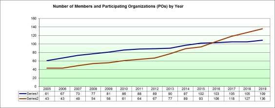
Total GEO Membership: 109
He then welcomed the Participating Organizations joining GEO:
African Smart Cities Foundation;
Caribbean Institute for Meteorology and Hydrology (CIMH);
Conflict and Environment Observatory (CEOBS);
Cooperación Latino Americana de Redes Avanzadas (RedCLARA);
Economic Community of West African States (ECOWAS);
Mercator Ocean International;
7 / 54XVII GEO Plenary – 4-5 November 2020 GEO-XVII-xx.x
Open GeoHub Foundation (OpenGEOHub);
Sustainable Development Solutions Network (SDSN);
World Food Programme (WFP).
Total GEO Participating Organizations: 136
Finally, Mr Camara welcomed newly accepted private sector entities in the GEO
Associate category:
Acclimatise Group Ltd;
Beijing Piesat Information Technology Co (Piesat);
Environment Systems Research Institutes Inc (ESRI);
ICES: International Centre for Earth Simulation Foundation;
PCI Geomatics;
Space Enabled Research Group MIT Media Lab;
Space Will Info Co Ltd (SpaceWill);
SuperMap Software;
Terradue;
The Centre for Ecological Research and Forestry Applications (CREAF);
Trimble.
Total GEO Associates: 11
1.4 Approval of Agenda
Outcome: The agenda was approved, with no modifications.
1.5 Approval of Draft Report of GEO-XV Plenary
Outcome: The draft report was approved, with no modifications.
1.6 Opening Keynote Presentation
Mr Sameh Wahba, The World Bank, gave a presentation on Geospatial Technologies for
Resilient & Sustainable Cities & Economies. He outlined the major trends shaping our
world today include urbanization & demographics, climate change, conflict and
technology. With 60% of the world’s population predicted to live in major city
metropolitan areas by 2030, the future is urban where 80% of the planet’s activities will
be taking place. In this context, he noted that, according to the Economist (2017), data is
to this century what oil was to the previous one. New technologies are making it possible
for Earth observation data (drones, satellites, cell phones, crowd sourcing) to be
processed and analyzed “good, fast and cheap”, a 3-way nexus that has never before been
feasible. Especially in the urban context, geospatial technologies are enabling better
planning, better service delivery, strengthened resilience and revenue enhancement. He
then went on to illustrate how these new technologies were being put to use via several
case studies, such as crowdsourcing being used to create flood maps for Dar Es Salaam,
Tanzania; drone mapping used to study urban and territorial dynamics in Zanzibar; data
from multiple observation platforms being combined to analyse retrofitting possibilities
for resilient housing in Saint Lucia, Guatemala; and rapid city scan techniques using
publically available data used to mainstream resilience in urban planning for
Ulaanbaatar, Mongolia.
8 / 54XVII GEO Plenary – 4-5 November 2020 GEO-XVII-xx.x
Mr Wahba concluded by noting that the World Bank was working collaboratively with
several cities to operationalized a mix of diagnostics and products under a four pillar
framework:
Institutional Arrangements: the ability to develop/sustain public policies,
regulations and governmental structures that support activities related to
geospatial concepts. Similarly, it refers to the role that local government has to
promote the growth of the geospatial environment;
People: creating awareness about the capacity needed for human resources and
identifying gaps in those resources with respect to geo-spatial abilities
(production, maintenance and use of spatial data);
Data: assessments of current situation of data availability, quality and policies
related to formats, analysis and geospatial information exchange;
Systems: the infrastructure (software and hardware) required to support a
Municipal Spatial Data Infrastructure (MSDI). Its key components are the
adequacy, the functionalities and the user interface of city-level Geoportals
that combine GIS and tabular data with spatial references.
1.7 Introduction of the Canberra Ministerial Declaration
Mr Stuart Minchin outlined the process followed by the Ministerial Working Group to
develop the Canberra Declaration, which included interaction with GEO Principals at
several stages. The principle themes of the Declaration included:
1. Acknowledge the progress made. Appreciation of the extensive efforts;
2. Investments in the Digital Economy and critical role of Earth Observations;
3. Importance of the inclusion of Developing Island Nations;
4. Note and realise the benefits for Regional, National, Sub-National, individual
communities and businesses;
5. Ensure benefits also available for all countries;
6. Continue to realize and contribute to the success of the GEO Strategic Plan
2016-2025. Build on efforts to support international policy agendas.
The next steps include a resolution for Minister to meet again in four years to:
assess GEO’s progress towards the goals, objectives and priorities; and
consider new challenges and themes to guide consideration of GEO’s future
beyond the term of the current Strategic Plan.
Before closing the session, the Chair made the announcement that, thanks to a visit from
the Secretariat Director in April this year, the China National Space Administration
(CNSA) had taken the decision to provide free and open access to 16m resolution satellite
data from its Gaofen satellites. Specifically, access to three types of data with coverage
outside China will be provided: historical records; daily updated Wide-Field-of-View
(WFV) images; and global coverage data. Additionally, China will provide PIE online
software for the better use of WFV data with a swath of 800 km. The data platform
CNSA-GEO, hosted by the Huawei Cloud, allows registered users around the world to
freely discover and download the WFV data. Users can use the data without restrictions
as long as they cite the source of the data. The Plenary expressed its appreciation for this
announcement with a round of applause.
9 / 54XVII GEO Plenary – 4-5 November 2020 GEO-XVII-xx.x
2 ACTION ON CLIMATE CHANGE
2.1 Session Objectives: The main objective of the session was for GEO Principals to
provide guidance on actions for GEO to accelerate its efforts to address climate
change including supporting countries in their implementation of the Paris
Agreement.
The session consisted of an introductory keynote talk by an invited speaker, followed by
a moderated open discussion with GEO Members. The session was closed with a
summary of the discussions.
The Speakers included:
Mr Patrick Child, Deputy Director-General, Directorate-General for Research
and Innovation, European Commission;
Mr Nga Puna, Director, Tu’anga Taporoporo - National Environment Service,
Cook Islands;
Mr David Oehmen, Associate Programme Officer for Digital Strategy and
Innovation, United Nations Framework Convention on Climate Change
(UNFCCC) secretariat;
Mr Steven Ramage, Head of External Relations, GEO Secretariat (providing
support to the facilitator and speakers).
Based on the discussion paper prepared by the GEO Secretariat, Mr Child invited
delegates to focus their interventions on:
The role of GEO to improve the use of EO for monitoring and understanding of
climate change;
Engaging with key partner institutions, such as IPCC and UNFCCC;
Best approaches on the use and application of EO in support of Member
actions on climate change;
Enhancing the GWP for the use of EO to inform and monitor mitigation and
adaptation;
Prioritising action for the GEO Secretariat on climate change.
Mr Puna delivered his opening keynote by presenting the perspectives and issues of the
Cook Islands, 15 islands spread out in 240 square kilometres of ocean that have faced
climate change for a long time. Mr Puna acknowledged the importance of data collection
and monitoring for Small Island Developing States (SIDS) in the Pacific and the ambition
to be part of GEO in order to be able to monitor changes and future-proof or climate-
proof the environment policies that his government is expected to deliver.
Mr Puna said he was impressed with the display of technologies and solutions presented
at the GEO Week. Mr Puna highlighted the fact that SIDS, such as the Cook Islands
have little margin of error in the face of climate change. The increased occurrence and
severity of king tides and beach erosion is already a reality in these countries, against the
overall lack of early warning systems.
Mr Puna then asked the audience a challenging question: “what would you do if you
knew you could not fail?”, and in concluding his intervention he made a plea to the GEO
community “not to leave anyone behind” and support the efforts of the Cook Islands and
all SIDS as Earth observations can provide small nations the right perspective and
10 / 54XVII GEO Plenary – 4-5 November 2020 GEO-XVII-xx.x
instruments to fight the climate change battle and take care of the environment for
future generations.
Following the keynote talk, the session facilitator Mr. Child then opened the floor to
discussions and interventions from GEO Members.
Australia noted the existing experience in using Earth observation data in support of
climate change action, and in particular the building of a robust monitoring system for
Australia’s greenhouse gas (GHG) inventory system. One of the main innovations was
the use of Landsat data for carbon stock monitoring. Australia used free and open
Landsat data to monitor changes in forest cover and then linked that observation data
with an advanced ecosystem model. The idea of linking the Earth observation radar with
important datasets and modelling to help draw out the implications of the Earth
observations data was really important in the case of Australia, where data on forests
were lacking. This is a common situation in many developing countries. The Australian
experience is a living proof of the value of Earth observation data.
Furthermore, another valuable example is the Global Forest Observation Initiative (GFOI)
that has produced detailed methods guidance standards to assist countries in developing
their measuring and reporting capabilities in the context of reducing emissions from
deforestation and forest degradation, and foster conservation, sustainable management
of forests, and enhancement of forest carbon stocks (REDD+) in conjunction with the
guidance provided by the IPCC.
Regionally, other relevant initiatives include forest monitoring through the Asia Pacific
Rainforest Summit that Australia helped establish these last few years, and the ongoing
establishment of the International Partnership for Blue Carbon where Earth observation
data can be important.
The Netherlands informed the GEO community about the Global Commission on
Adaptation, an initiative by several international organisations and supported by the
Dutch government, aimed to share knowledge on climate change adaptation. The
Netherlands suggested GEO to explore collaboration with the Global Commission on
Adaptation also with a view to engage in the Climate Adaptation Summit in October
2020.
China noted the ongoing efforts to achieve global CO2 emission reductions and the goals
set in Nationally Determined Contribution (NDC), including through developing GHG
satellites techniques. China has launched TanSat, GAOFEN series TF 5, and
meteorological satellite series, which makes China the country with the largest GHG
satellite constellation. In addition, China is soon launching high-resolution TanSat CO2
data which will make a contribution to global CO2 observations. A new GHG satellites
called Atmospheric Environmental Monitoring Satellite(AEMS) will be also launched in
2021, which will be followed by another high-precision GHG satellite in 2023.
China welcomes cooperation with other space agencies to reduce the uncertainty of the
national GHG emission inventory reporting. Cooperation with Japanese and American
space agencies is already ongoing, and this represents a good example of how to use the
space techniques for GHG monitoring.
11 / 54XVII GEO Plenary – 4-5 November 2020 GEO-XVII-xx.x
International cooperation especially under GEO will provide guidance to promote
emission reduction strategies and track changes in the natural carbon cycle caused by
anthropogenic activities and climate variability.
The European Commission noted that the European Union (EU) is deeply engaged in
supporting the global effort in the domain of climate change for the benefit of Europe
and also for the benefit of the world. The European Commission’s overall expectations
from GEO include, firstly, continuing the efforts to collect, make available and upscale
Earth observation climate knowledge already existing in GEO members. With that it will
be possible to support the EU engagement regarding environmental sustainability, as
well as combating and adapting to climate change. These engagements are reflected in
the priorities of the new EU governance with the new European Commission’s President-
elect Ursula von der Leyen.
In practical terms, GEO should allow the EU member states and other countries to track
progress with regard to the Paris Agreement goals. To achieve this, GEO should
accelerate its effort to ensure an increased recognition of the value of Earth observations
in the IPCC and the UNFCCC, in particular producing a GEO information document that
would address specific needs of the IPCC, beyond the effort that is already taking place,
and in particular taking advantage of the recent IPCC special reports. GEO should be
prepared to support countries in meeting their NDCs, not by doing the work that the
countries should do but supporting them with technologies and information.
The European Commission encouraged GEO members to participate in side events and
exhibitions at the UNFCCC, the Conference of the Parties (COP) and the Subsidiary
Body for Scientific and Technological Advice (SBSTA) meetings. The European
Commission informed the audience that they will be present at COP25 taking place in
Madrid, Spain.
The European Commission supports an in-depth assessment of the relevant GEO Work
Programme (GWP) activities so that those resources can be made more visible.
Furthermore, the GWP should be drafted with the participation of key stakeholders,
going beyond the existing closed circle and involving parties like the Cook Islands. In
particular, GEO should focus its action around the use of Earth observations for impact
assessment and adaptation.
Finally, support should be given to GEO members so that they can approach their
national delegates and experts in the UNFCCC and the IPCC to promote the GEO added-
value role; in this context it would be very useful to prepare a standard briefing that
could be used by GEO members to contact their national counterparts in IPCC and
UNFCCC.
Greece noted that it is our duty as the GEO community to do all that is possible to
ensure that we pass a better and safer planet and environment to the next generation
who are increasingly mobilized and have asked for immediate climate action, at the same
time warning us that they will be watching us.
One great way as a community to build upon this momentum is to demonstrate that we
have great respect for our world’s cultural heritage. To this end, Greece has proposed to
the UN Climate Action Summit, an additional action needed to protect natural and
cultural monuments that are threatened by anthropogenic climate change. The proposal
12 / 54XVII GEO Plenary – 4-5 November 2020 GEO-XVII-xx.x
has been supported by WMO and UNESCO. It was presented in New York by the Prime
Minister of Greece who will organize a Summit to invite world leaders to endorse the
Greek initiative to the UN. The Secretary General of the UN, Antonio Guterres, has
already included the Greek proposal together with the group of emblematic proposals of
interest to the UN.
The Greek proposal provides a strong opportunity to the Global Earth Observation
System of Systems (GEOSS) and GEO, especially now that the regional GEOs have
agreed to be pioneers of this important issue, allowing us to work together on common
activities, co-design, traversing all three GEO engagement priorities and targeting the
use of Earth observations for the monitoring, the preservation of our planet’s cultural
heritage both natural and man-made. It is anticipated that such a proposal would
strengthen cohesion within GEO and create unique opportunities for collaboration
between the regional GEOs with a focus on protecting our past in order to create a better
future for everybody.
France recalled that the science message is very clear: countries are not on track to
achieve the temperature targets set by the Paris Agreement. As climate marches around
the world led by active youth remind us of our responsibilities towards future
generations, we need to define concrete and integrated responses from global to local to
fight climate change based on the best available scientific knowledge.
That is why, the EU launched the Copernicus Climate Change Service as an operational
service in June 2018, and why the Space Climate Observatory was launched by President
Macron in June 2019 by 26 space agencies and organizations that signed a Joint
Declaration of Interest. The Space Climate Observatory is aiming at studying and
monitoring the impacts of climate change, especially at local scales, using satellite-based
Earth observation tools in combination with field data and models. In this way it will
complement and extend existing initiatives, boosting them at national and local scales.
So in the framework of best approaches of the use of Earth observations in support of
member actions on climate change the Space Climate Observatory could therefore be
included in the list of opportunities to be supported.
Japan considers that the 2019 refinement of the IPCC Guidelines for National GHG
Inventories was a great step forward for the GEO community, in which the role of
satellite observation data, including that of GOSAT2 of Japan, is now recognised as one
of the ways to measure global GHG emissions. Japan is grateful for the efforts by the
GEO community in terms of integrating Earth observations according to the IPCC
Guidelines. At the same time, it is up to our future efforts to try to integrate the satellites
as observation data into the methodology to measure and assess global GHG. Japan
pointed out that the GEO community needs to keep on working in this area including
the response to the first global stocktake of the Paris Agreement in 2023.
The United Kingdom informed the meeting that the UK planned to host a side event
alongside COP25 on the role of Earth observations to support efforts in tackling climate
change. The event will cover four main themes: measuring ice from space; oceans, and
using Earth observations to measure marine climate variables including ocean
acidification; natural hazards and climate change, and the relationship between those
and what Earth observations can do to help.
13 / 54XVII GEO Plenary – 4-5 November 2020 GEO-XVII-xx.x
The UK also noted that an important theme for GEO is nature-based solutions and how
Earth observation can support work not only in measuring climate change, but also
looking to mitigate the impacts of climate change using natural solutions.
Following the interventions from the floor, the session facilitator Mr. Child then
introduced the second speaker, Mr Oehmen from the UNFCCC secretariat.
Mr Oehmen opened his talk by reminding the audience that high quality Earth
observations are the foundation for solid decision making on future action on climate
change. The Paris Agreement was mandated based on the best available scientific
information. Observation is pivotal to providing the alerts on global temperatures
related to the 1.5 and 2 degree C temperature limits under the Paris Agreement, as well as
other climate indicators to assess progress on the Paris Agreement goals.
Under the UNFCCC, the SBSTA is the place where scientific information is brought into
the process and discussed, particularly under the research and systematic observation
agenda item, including the research dialogue and the Earth Information Day. The
UNFCCC secretariat works closely with a number of international and regional
organizations to enable information exchange at the science-policy interface.
Mr Oehmen added that GEO has a unique role to play in serving the Paris Agreement.
The Global Climate Observing System (GCOS) Essential Climate Variables provide a
basis for decision making at all levels on action for both mitigation and adaptation as
well as assessing progress. First of all, GEO is well positioned to support the provision of
ECVs, particularly for the terrestrial domain. Also, GEO could support Parties and the
broader community in the provision of socioeconomic variables. One recommendation is
for GEO to develop a set of essential socioeconomic variables, with the same concept as
ECVs and with appropriate quality control and in the context of FAIR (Findable,
Accessible, Interoperable, Reusable) data sharing principles.
Secondly, Mr Oehmen noted that, to reach its goals, the Paris Agreement outlines a
“cycle”:
Countries provide a national climate target every 5 years (current NDCs will be
altered or updated in 2020); these communicated targets are “nationally
determined”, but must be stronger than the previous targets;
With their NDC, Parties will also provide a long-term low GHG-emission
development plan;
Countries then undertake action to meet the targets identified in their NDCs
(with developing countries receiving appropriate support);
Starting in 2024 and every subsequent 2 years, countries report on action taken
through a transparent reporting process;
Starting in 2023, there will be a global stocktake to look at collective progress
towards the goals; the stocktaking recommends ways to be more ambitious in
the next cycle;
Following each global stocktake, countries will take the recommendations and
their experiences home, and then, provide more ambitious targets in the next
round.
14 / 54XVII GEO Plenary – 4-5 November 2020 GEO-XVII-xx.x
In their NDCs, Parties are responsible for identifying indicators to track progress.
Against this background, Mr Ohemen pointed out that GEO could explore how to
support Parties identify and track indicators, particularly for adaptation.
Thirdly, Mr Oehmen informed the Plenary that, in a recent paper the Least Developed
Countries Expert Group (LEG) and the Adaptation Committee, two constituted bodies
under the UNFCCC, identified gaps and needs for countries to integrate science in
adaptation planning and implementation. Four gaps/needs relevant for this discussion
are:
The capacity of national, subnational and sector experts to work effectively with climate
data and climate change scenarios in adaptation planning and decision making;
Availability and accessibility of climate data and climate change scenarios to underpin
effective adaptation planning and implementation, taking into account the specific
needs at the national, subnational and sectoral level;
Capacity to develop, analyze and define baselines;
Capacity to undertake comprehensive risk and vulnerability assessments covering all key
sectors and systems at the national, subnational and sectoral level.
Therefore, to track progress in the reduction of vulnerability from National Adaptation
Policies (NAP) implementation – any indicator must have a baseline for adaptation to
monitor change; be framed in a manner that policy makers understand; be responsive to
the physical science, e.g. temperature, support planning; be ample and consistent, such
that trend lines can be established to assess progress; be aggregated to assess collective
progress.
Mr Oehmen raised a number of questions for the GEO community. In particular, he
asked to consider how GEO can support Parties use Earth observation information better
to provide a baseline for NAPs and NDCs as well as support implementation and
tracking long-term progress.
Finally, Mr Oehmen stated that we are moving into a new age of satellite imagery. Space
4.0 represents a new era for the space sector, characterised by a new playing field. This
era is unfolding through interaction between governments, private sector, civil society
and politics. Information from satellites will be fully integrated with other observations
and data. It will be processed using big data analytics and artificial intelligence (AI) to
produce real-time, high-resolution, relevant information for society to provide
collaborative data-driven and transformational risk-informed decision-making tools for
policy and investment, while also monitoring ambition progress. Mr Oehmen asked how
GEO can mobilize this information to support the Paris Agreement and at the same time
enable global wellbeing, sustainability and equity.
In closing his intervention, Mr Oehmen encouraged the GEO community to reach out to
support this important work, find opportunities to bring the open data, knowledge and
services needed to promote the implementation of the Paris Agreement at global,
regional and national level. He also informed the audience that all efforts are being taken
to ensure the full execution of side events at COP25 despite the recent change of venue.
Mr Child then took into account some of the comments that were submitted through
sli.do, including the need to: use GEO monitoring systems to track impacts of climate
15 / 54XVII GEO Plenary – 4-5 November 2020 GEO-XVII-xx.x
change in the Arctic; use Earth observations to help with the necessary transition in
particular of energy-intensive industries; focus Earth observation work on adaptation;
and make better use of data knowledge and systems.
Mr Child opened the floor again for interventions.
The representative of the Sustainable Development Solutions Network (SDSN) TReNDS
group addressed the issue of coordination between GEO and the IPCC. The IPCC has
recently reconstituted the Task Group on data. The representative of SDSN is an ex
officio member and noted that the Task Group is meeting in Montreal Canada at the
same time as this GEO Plenary and will be addressing key issues related to data from the
IPCC assessments. The recommendation is that the GEO Secretariat initiates a
discussion about coordination with the Task Group on data.
Australia spoke to the importance of Earth observations in helping agriculture and food
security in a changing climate. Three propositions were presented alongside concrete
examples. First, Earth observations are crucial to understanding and properly managing
natural resources, including agricultural production. Research by the Australian
Government - Agricultural Research Bureau, looking at the impacts of variability and
change, linked decades of admin survey data to Bureau of Meteorology’s weather data
and applied advanced machine learning to find out that the shifting climate conditions
entirely explained a complete pause in agricultural productivity growth for a decade
from 1995, and that adaptation so far has not managed to fully re-establish previous
productivity levels.
The second proposition is that Earth observation remote sensing capabilities are
improving rapidly, and this offers all sorts of improved decision support. These include
on-farm decision support, as well as off-farm or wider decision support such as
understanding the pattern of biosecurity spread through understanding plantation
density in vineyards and bananas for example, which also helps with compliance and
trust in the system.
Thirdly, while agriculture researchers appreciate the benefits of improved real-time
information and decision support, the step changes, the major gains are going to occur
when Earth observations are combined with information and data from other sources to
deepen our understanding of the system, the complex natural systems we live in and the
social and economic systems that are intertwined with them. For instance, it would be a
game changer in Australia to have reliable regional long-term weather forecasts. For
farmers struggling with that, improved parametric insurance would be fabulous and
enable them to manage risks that they can't currently manage. Proper quantification
assessment of a wide range of ecosystem services would be a great value to public and
private decision makers including through the design and implementation of improved
policy programs; this would include the management of environmental water. And lastly,
improved evidence-based understanding of the impacts of climate variability and change,
and how these might be managed to mitigate, is central to the future of agriculture
around the world and associated food systems. Taking that evidence base and then
putting it into public models and forecasts and scenarios of climate change and impacts
under different GHG emissions trajectories is crucial to understanding the relative merits
of different pathways and motivating sensible global action.
16 / 54XVII GEO Plenary – 4-5 November 2020 GEO-XVII-xx.x
2.2 Panel session outcomes and recommendations
At the end of the session the facilitator Mr Child noted that there is a strong interest and
mobilisation in the GEO community to become more directly involved and more directly
relevant in the debate on climate change. The following outcomes highlight some of the
ways to take action, that were distilled from the talks and the interventions:
International cooperation and new sensors are increasingly important for
national GHG inventory;
There should be a focus on supporting developing countries through guidance
on the use of Earth observations for climate action, upscaling and/or sharing
existing knowledge;
There should be a focus on increasing the recognition of GEO within the
UNFCCC, and engagement with other partners such as the IPCC, the Global
Commission on Adaptation and the Space Climate Observatory;
Additional stakeholders should be included in the GWP development;
There should be a focus on Earth observations in support of the Arctic, Clean
Energy, Cultural Heritage, and Adaptation, particularly for the Agriculture
sector;
The GEO community present at COP25 will include: the UK, Germany, Japan,
EC, Kenya, Chile, Spain, and other Members.
3 ACTION ON DISASTER RISK REDUCTION
3.1 Session Objectives: Principals provide guidance on the actions that GEO
needs to take to accelerate its efforts to support implementation of the
Sendai Framework for Disaster Risk Reduction.
This session was organized with an introductory keynote talk by an invited speaker,
followed by a moderated open discussion with GEO Members. The session was closed
with a presentation by a representative from a GEO Participating Organization followed
by a summary of the discussions.
The speakers included:
Mr Yoshiyuko Chihara, Deputy Director-General, Research and Development
Bureau, Ministry of Education, Culture, Sports, Science and Technology
(MEXT), and GEO Principal of Japan;
Ms Lisa Robinson, Head of Advisory at British Broadcasting Corporation (BBC)
Media Action;
Ms Tiziana Bonapace, Director Information and Communications Technology
and Disaster Risk Reduction Division, UN Economic and Social Commission
for Asia and the Pacific (UNESCAP);
Mr Steven Ramage, Head of External Relations, GEO Secretariat (providing
support to facilitator and speakers).
Ms Robinson was representing BBC Media Action, which is an NGO and the BBC’s
international development charity. Ms. Robinson gave the opening keynote to the
session which focused on “Five mistakes of communicating risk”. The talk focused on
how GEO can accelerate its impacts in disaster risk reduction, and make effective use of
17 / 54XVII GEO Plenary – 4-5 November 2020 GEO-XVII-xx.x
the data that the GEO community generates and uses. More specifically, there was a
focus on the role of communication in reducing disaster risk. Ms. Robinson's talk mainly
focused on communication to the public, as this is the focus of BBC Media Action, but
can equally be applied to governments and decision makers.
The talk focused on five mistakes that are typically made when communicating risk. The
mistakes are:
Assume that information leads to action;
Skimp on audience research;
Create a snazzy product with no solid plan for change;
Avoid conversation; and
Be dull.
The first mistake ‘Assume that information leads to action’ is related to the Sendai
Framework for Disaster Risk Reductions Priority for Action 1: Understanding Disaster
Risk. It touched on the need to be realistic about what actions we expect the information
we create and provide to result in and why it is difficult for these actions to take place.
Mistake one also focused on cognitive bias in responding to a disaster event, and the
challenges of the social constructs that we inhabit. Disaster risk reduction requires a
systematic approach and although difficult should be considered as part of the
communication processes.
Mistake 2 ‘Skimp on audience research’: people and the environments in which they live
are extremely complicated. Investing in understanding people and the environment, and
how the two interact is crucial to understanding them. Demographic information is
helpful but it is only part of the picture. Understanding what motivates people and their
priorities allows you to identify ways to help motivate them and make plans which may
be outside normal messaging campaigns.
Mistake 3 ‘Create a snazzy product with no solid plan for change’: There is a place for
apps, maps, and other products and they are key to how we communicate risk, however
they need to be linked to a solid plan for change. Ms Robinson reminded the audience
that communication about risk is not a product, rather it is a process.
Mistake 4 ‘Avoiding conversations’: Discussions around risk reduction happen at
multiple levels, the personal/individual level and the community/governance level. We
need to be having these often difficult conversations before a crisis happens. Sharing
information also brings with it the risk of sharing misinformation, this is not a new
concept, but one that is more prevalent nowadays. The proactive provision of
information avoids the creation of knowledge voids, which are at risk of being filled with
misinformation.
Mistake 5 ‘Be dull’: Talking about disaster risk reduction doesn’t have to be dull,
especially if we are trying to communicate potentially abstract or complex issues to busy
people. Communication should be engaging and relatable to peoples’ daily lives.
Ms Robinson finished off her talk by summarizing that we are all in the same boat it
often takes a joint effort by media professionals and technical experts, and that we
should work together to communicate disaster risk reduction for action.
18 / 54You can also read