BUSINESS GUIDE 2 ISSUE 1 - GIM International
←
→
Page content transcription
If your browser does not render page correctly, please read the page content below
THE GLOBAL MAGAZINE FOR GEOMATICS
                                                            WWW.GIM-INTERNATIONAL.COM

                                          INTERNATIONAL
                                          ISSUE 1

                                         BUSINESS GUIDE

                                                                                  2021

                           INDUSTRY SURVEY: CAUTIOUS OPTIMISM
                                       EMERGING FROM COVID-19
                                      THE FUTURE OF GEOSPATIAL
                  UNLOCKING POTENTIAL: GEO-TRENDS FOR BUSINESS
                                   TECH DRIVERS FOR SURVEYING

01_cover.indd 1                                                                 28-01-21 11:18
E300 Pro
                                       E300 Pro is a new generation product by eSurvey
                                       GNSS. The durable IP67 design makes it possible to
                                       work in various of environments. Multi constellation

GNSS                                   and frequency tracking always gives a Fixed solu-
                                       tion for your job. Thanks for the small-size design,

RECEIVER
                                       E300 Pro is suitable for different applications such
                                       as car and machine control.

www.esurvey-gnss.com                                              info@esurvey-gnss.com

Copyright c e-Compass Science & Technology Inc. All rights reserved.
CONTENTS
DIRECTOR STRATEGY & BUSINESS DEVELOPMENT P. 7 Reader Survey – Cautious Optimism in Geospatial
Durk Haarsma
FINANCIAL DIRECTOR Meine van der Bijl
Industry Despite Coronavirus
TECHNICAL EDITOR Huibert-Jan Lekkerkerk
This year’s annual GIM International industry survey was conducted in late
CONTRIBUTING EDITORS Dr Rohan Bennett, 2020. After a year in which the COVID-19 pandemic turned everyday life
Frédérique Coumans upside down in many parts of the world, it seems more important than ever
CONTENT MANAGER Wim van Wegen to gauge the mood of the geospatial business. Encouragingly, despite all the
COPY-EDITOR Lynn Radford, Englishproof.nl trials and tribulations caused by coronavirus, there are plenty of bright spots
MARKETING ADVISOR Feline van Hettema helping to keep spirits high in the mapping and surveying profession. This
CIRCULATION MANAGER Adrian Holland article outlines the key findings from the survey.
DESIGN ZeeDesign, Witmarsum, www.zeedesign.nl
GIM INTERNATIONAL
GIM International, the global magazine for geomatics, is
P. 13 Emerging from COVID-19
published bimonthly by Geomares. The magazine and related The geospatial industry has been more fortunate than others during the
e-newsletter provide topical overviews and accurately presents COVID-19 pandemic. In fact, there are some exciting opportunities relating
the latest news in geomatics, all around the world. to accelerating the digital transformation so that businesses can adapt to
GIM International is orientated towards a professional and the ‘new normal’, as well as economic stimulus packages with a greater
managerial readership, those leading decision making, and has emphasis on green growth. This article, by Andrew Coote of ConsultingWhere,
a worldwide circulation. examines these and other influences that are likely to shape the future of the
geospatial industry.
SUBSCRIPTIONS
GIM International is available bimonthly on a subscription
basis. Geospatial professionals can subscribe at any time via
https://www.gim-international.com/subscribe/print. P. 17 The Future of Geospatial: Are We Everyone’s Friend or Do
Subscriptions will be automatically renewed upon expiry, unless They Not Know We Exist?
Geomares receives written notification of cancellation at least Vanessa Lawrence has been assisting senior government officials from both
60 days before expiry date. developing and developed countries during the last five years. She sheds a
light on the future of geospatial coming from her experience as a consultant
ADVERTISEMENTS in an environment where most senior government officials and senior
Information about advertising and deadlines are available in directors of organizations do not normally recognize terms like ‘geospatial
the Media Planner. For more information please contact our
information’, ‘our geospatial community’ or even ‘the GIS team’.
marketing advisor: feline.van.hettema@geomares.nl.
EDITORIAL CONTRIBUTIONS
All material submitted to Geomares and relating to P. 21 Unlocking Potential: Emerging Geospatial Trends for
GIM International will be treated as unconditionally assigned Business
for publication under copyright subject to the editor’s The latest version of the Future Trends in Geospatial Information Management
unrestricted right to edit and offer editorial comment. Geomares report by UN-GGIM captures technological and non-technological
assumes no responsibility for unsolicited material or for the developments and signposts opportunities for change. David Henderson and
accuracy of information thus received. Geomares assumes, in James Norris have identified opportunities for organizations and businesses
addition, no obligation to return material if not explicitly
to adapt and advance their geospatial maturity in the coming years.
requested. Contributions must be sent for the attention of the
content manager: wim.van.wegen@geomares.nl.
P. 26 Key Global and Technology Drivers Impacting Surveying
FIG commission chairs, near the halfway point in their terms, reflect on
the global and technological drivers influencing their work. This article
outlines how the work across the FIG commissions supports the Sustainable
Geomares Development Goals. The discussion is also informed by global reports such as
P.O. Box 112, 8530 AC Lemmer,
The Netherlands the UN-GGIM’s Future Trends in Geospatial Information Management and the
T: +31 (0) 514-56 18 54 RICS Futures Report 2020.
F: +31 (0) 514-56 38 98
gim-international@geomares.nl
www.gim-international.com
No material may be reproduced in whole or in
part without written permission of Geomares.
Copyright © 2021, Geomares, The Netherlands
All rights reserved. ISSN 1566-9076
P. 5 Editorial Note
P. 13, 33 and 42 Q&A
P. 34 Company Profiles
THE GLOBAL MAGAZINE FOR GEOMATICS
WWW.GIM-INTERNATIONAL.COM
ADVERTISERS
To subscribe to GIM International go to www.gim-international.com/subscribe INTERNATIONAL
E-Survey 02 Tersus 22 ISSUE 1
BUSINESS GUIDE
2021
ComNav Technology 04 ImpulseRadar 27
Teledyne Optech 06 Hi-Target 30
Phase One 11 Harxon 36 COVER STORY
RIEGL 12 Geo-allen 36
Geo-matching 13 SBG Systems 38
European Space Imaging captured this image over Paris, France, with WorldView-3 in April 2020
South Surveying 15 GinTec 38 during the first phase of COVID-19 lockdowns. The image was acquired in the effort to assist EU public INDUSTRY SURVEY: CAUTIOUS OPTIMISM
EMERGING FROM COVID-19
Shanghai Huace 19 Zoller + Fröhlich 43 institutions and media outlets with visual overviews of deserted tourist hotspots, airports and highways THE FUTURE OF GEOSPATIAL
UNLOCKING POTENTIAL: GEO-TRENDS FOR BUSINESS
Schneider Digital 19 TI Asahi 44
to assist decision-making aimed at addressing the economic and logistical impacts of the pandemic.
TECH DRIVERS FOR SURVEYING
01_cover.indd 1 28-01-21 11:18
BUSI NESS GUI DE 2 0 2 1 | INTERNATIONAL | 3
03_contents.indd 3 28-01-21 13:24

editorial notes

                           Looking beyond
                           Our aim with this year’s GIM International Business Guide is to give
                           you a glimpse of tomorrow’s geospatial industry. Needless to say, this
                           is a very difficult time to be trying to predict the future, and yet we are
                           all eager to know when we will be able to visit our friends and family
                           again, eat out at a restaurant, attend a concert or festival and travel
                           wherever we want. For many of us, professional life has almost come
                           to a standstill due to the COVID-19 pandemic – or at the very least our
                           world has shrunk as we are restricted to working from home, with no
                           tradeshows or business trips and contact with colleagues and business
                           contacts limited to videoconferencing at best.

                           ‘Forewarned is forearmed’ as the saying goes, and that is fully in line
                           with what we try to accomplish at GIM International. By keeping you
                           – our readers – informed, we aim to give you a head start in preparing
                           for the future… whatever it may bring. So in this Business Guide we
                           attempt to look beyond the end of the pandemic, to paint a picture of
                           where the industry is heading and what the longer-term consequences
                           of this crisis might be. Based on the responses in our yearly reader
                           survey, we can conclude that cautious optimism prevails over
                           pessimism about the coronavirus crisis thanks to some bright spots
                           keeping spirits high (see page 7). David Henderson and James Norris
                           from the UK’s Ordnance Survey have written about one of UN-GGIM’s
                           most important reports in their article titled ‘Unlocking Potential:
                           Emerging Geospatial Trends for Business’ (page 21). Additionally,
                           Andrew Coote has envisaged the geospatial industry after COVID-19
                           (page 13) and Vanessa Lawrence shares her predictions for the future
                           of geospatial data (page 17). After reading this edition, you should
                           have a clearer – and well-founded – idea of what probably lies ahead.

                           This is a good opportunity for me to proudly introduce our new
                           technical editor, Huibert-Jan Lekkerkerk, who is a trained professional
                           with extensive experience in both geomatics and hydrography. In fact,
                           Huibert-Jan is a teacher, an analyst and a consultant all rolled into one
                           and he has been a member of our editorial board for several years.
                           Following the retirement of our senior editor Tjeu Lemmens last year,
                           Huibert-Jan has agreed to join us in supporting our readers in their
                           professional lives by bringing them the latest news and developments
                           in geomatics technology. Huibert-Jan will be a regular contributor to
                           GIM International from now on, so if you want to suggest ideas for
                           articles, you can contact him on info@hydrografie.info. I wish Huibert-
                           Jan all the best in his new role!

                           In the context of looking beyond, I would like to conclude by wishing
                           you all the best for 2021 – both personally and professionally – from
                           everybody here at GIM International. May health and prosperity go
                           hand in hand as we leave the challenging times behind us and seize
                           new opportunities that lie ahead!

                                                            Durk Haarsma,
                                                            director strategy & business
                                                            development
                                                            durk.haarsma@geomares.nl

                                                                                                         busi ness gui de 2 0 2 1 |   international | 5

05_editorialnotes.indd 5                                                                                                                        28-01-21 11:18
TELEDYNE OPTECH AND TELEDYNE CARIS

                                                                            Image by Ocean Surveys, Inc.

                 Geospatial solutions
                 designed to capture
                 the bigger picture
                 Through the breadth and scope of unified sensors, processing
                 and fusion capabilities we can provide analytics for both land
                 and water for holistic data whenever you need it.

Discover more at                                                          TELEDYNE OPTECH
                                                                          Everywhereyoulook
                                                                                                 TM

www.teledynegeospatial.com

Copyright © 2021 Teledyne CARIS / Teledyne Optech. All rights reserved.
Product Preview

        Harxon TS112
                                                                                               Pentax G7N
                                                                                                                                           The Pentax G7N is a GNSS smart
                                                                                                                                           antenna that will debut in spring
                                                                                                                                           2021 as the latest model in the
                                                                                                                                           Pentax GNSS receiver family.
                                                                                                                                           Based on a powerful GNSS engine
                                                                                                                                           with precise point positioning
        Harxon’s TS112 smart antenna family adopts Harxon’s latest positioning                                                             (PPP) capability, the G7N
        technology and offers scalable positioning solutions with increased GNSS                                                           integrates an inertial measurement
        availability, reliability and accuracy for demanding applications such as              unit (IMU), wireless datalinks and web UI system management for a
        agricultural machine autosteering, even in harsh environments. Each model of           complete field solution. The G7N has 555 channels for full tracking of all
        the TS112 family embeds a Harxon X-Survey technology 4in1 multifunctional              major satellite constellations for fast fixed RTK initialization. The IMU
        GNSS antenna that integrates 4G, Bluetooth and Wi-Fi in one compact unit.              complements the position solution with full 3D orientation that provides tilt
        This high-gain GNSS antenna features multi-point feeding technology, ensuring          and azimuth for more efficient and accurate surveying. The integrated
        ultimate RTK centimetre-level positioning accuracy. The TS112SE, as the most           wireless datalinks include a global cellular modem, a full-band UHF radio,
        affordable solution of the three, provides flexible positioning solutions via          Bluetooth and Wi-Fi for cable-free operations. Two hot-swappable batteries
        standalone positioning or dual-frequency precise point positioning (PPP) with          provide continuous operation and an SD card provides additional memory
        accuracy from sub-metre to centimetre level while using the SAPA precise               up to 32GB. Traditional serial communication, external power and UHF
        augmentation service. The SAPA precise augmentation service works as a                 antenna are included with ports on the bottom of the G7N. The innovative
        reliable and economical alternative positioning option with wide service coverage      mechanical design of the G7N features a small and lightweight
        in application environments that have poor LTE network coverage. The TS112             magnesium alloy housing, certified to IP67 standards for all-weather use.
        integrates a high-precision GNSS module with multi-band GNSS receiver and              Furthermore, the product design facilitates superior access to the battery
        delivers RTK-level positioning accuracy for precision agriculture equipment and        ports, SIM card and SD card slots for easy insertion or removal in the field.
        machine control. It also integrates 4G and a UHF radio modem for flexible              Configuration and status can be easily reviewed and changed from the
        correction transmission in the field. The TS112 PRO employs a future-ready             on-board web UI that is accessible from any PC, tablet or smartphone via
        NovAtel OEM GNSS module, offering global centimetre-level positioning utilizing        Wi-Fi. The web UI also allows wireless firmware upgrade and data transfer.
        TerraStar satellite-delivered correction services without the need for network         Overall, the G7N combines multiple sensors for a robust and accurate
        infrastructure. Harxon’s TS112 PRO also supports NTRIP service, so in                  RTK solution for the land survey and GIS markets, with easy wireless
        application environments where it is not feasible to use a base station, the           access and flexibility as a base, rover or repeater.
        NTRIP differential corrections could be transmitted to a rover using 4G networks
        and enable users to achieve ultimate centimetre-level positioning accuracy.

                                                                                            Zoller + Fröhlich LaserControl
           ImpulseRadar                                                                     9.2
                                                                                                                                               Zoller + Fröhlich (Z+F) is one of
                                                         Whether for GPR novices or                                                            the world’s leaders in 2D and
                                                         experts, ImpulseRadar’s                                                               3D laser measurement
                                                         instruments provide a quick,                                                          technology and continues to
                                                         precise and dependable way                                                            develop innovative solutions for
                                                         to investigate the subsurface                                                         the surveying industry. Z+F
                                                         and maximize in-field                                                                 LaserControl Office and Scout
                                                         productivity and decision-                                                            are the optimal solution to work
                                                         making capabilities. The           efficiently and fully with the laser scanners of Z+F. A range of filters,
                                                         company’s thoroughly               measurement and registration tools enable high-differentiate processing of scan
                                                         modern range offers                data and are the key to filter, register and colour 3D point clouds. Thanks to the
                                                         industry-leading                   large selection of export formats provided by Z+F LaserControl, data can be
                                                         performance with real              imported and further processed in all common 3D software applications. Just as
                                                         benefits that will drive           important as very high-accuracy measurements is the precise registration of
                                                         results across a wide range        point clouds and thus the avoidance of gaps in projects. In Z+F LaserControl,
                                                         of application areas. Contact      users have several registration options. In addition to classic target registration,
                                                         ImpulseRadar to learn more         point cloud algorithms can also be registered together with Cloud-to-Cloud and
                                                         about its state-of-the-art         Plan-to-Plan (with the Scantra plug-in). These registration options are included
                                                         GPR solutions, including           in Z+F LaserControl Office (Premium) and Z+F LaserControl Scout. The new
                                                         PinPointR, CrossOver and           version of Z+F LaserControl 9.2 ensures a whole range of optimizations. In
                                                         Raptor.                            addition to the new light scatter compensation, there are many new tools in
                                                                                            Scout and Office that increase the workflow efficiency with the point clouds.

                                                                                                                                     busi ness gui de 2 0 2 1 |   international | 7

07_productpreview.indd 7                                                                                                                                                    28-01-21 11:37
INDUSTRY SURVEY 2021: BRIGHT SPOTS HELP TO KEEP SPIRITS HIGH

        Geospatial Industry
        Cautiously Optimistic
        Despite Pandemic
        This year’s annual GIM International industry survey was conducted the twilight of 2020. After a year in which
        the COVID-19 pandemic turned everyday life upside down in many parts of the world, it seems more important
        than ever to gauge the mood of the geospatial business. Encouragingly, despite all the trials and tribulations
        caused by coronavirus, there are plenty of bright spots helping to keep spirits high in the mapping and
        surveying profession. This article outlines the key findings from the survey.

        While some industries soared to new heights         iMpact of coVid-19                                 Unsurprisingly, the survey shows that the
        due to behavioural shifts caused by the             This year’s industry survey received responses     pandemic is affecting the business of almost
        pandemic, other sectors have taken a severe         from professionals in no less than 115             all mapping and surveying companies across
        hit. The global outlook is unclear, although        countries and with a wide variety of job titles,   all verticals worldwide. Many surveyors have
        financial analysts state that governmental          including consultant (31.3%), researcher/          experienced a decrease in activity due to
        stimulus measures – for instance in the USA         academic (17.8%), manager (16.5%),                 a reduced volume of work. Projects have
        and European Union – together with the              government official (9.7%) and technician          been delayed, postponed or even cancelled.
        expected upturns once the pandemic has              (7.8%). They also covered the broad spectrum       Revenues have fallen by 20%, 30% or even
        passed its peak will lead to new prosperity.        of sectors in which geospatial applications are    more due to the coronavirus restrictions. One
        “Vaccines will bring economy near recovery          used: 49.7% of the respondents are involved        respondent states that their business has
        by end of 2021” was the headline in Forbes          in land management, 39.6% in building &            been brought to a standstill.
        magazine in December 2020. Let’s hope it            construction, 35.4% in infrastructure, 27.3%
        comes true.                                         in urban planning and 14.3% in agriculture.        Similar challenges are being experienced
                                                                                                               around the world. Remote working is difficult
                                                                                                               when much of the activities involve field
                                                                                                               work, such as to collect spatial data. A survey
                   Better                                                                        41.4%         engineer from Hong Kong echoes this: “In
           1
                                                                                                               the construction industry it is hard to work
                                                                                                               from home. You can’t pour the concrete at
                   Much better                                                                   25.4%         home to ‘remote construct’ a project.” “It has
           2
                                                                                                               been pretty bad for us in the UK,” comments
                                                                                                               another respondent. “We don’t have any
                   Same                                                                          23.4%         projects in our area because of the pandemic,
           3
                                                                                                               so many people are leaving and resources
                                                                                                               are going to waste.” A consultant from
                   Worse                                                                           8.8%
           4                                                                                                   Bolivia states: “There are a lot of delayed or
                                                                                                               cancelled projects. We have seen a shift in the
                                                                                                               allocation of funds, from land administration
                   Much worse                                                                      1.1%
           5                                                                                                   to COVID-19.” A land survey professional
                                                                                                               from India sums up his position as follows:
          What are the expectations of the prospects in the surveying market in 2021 compared with the past    “Being confined to home has turned me in a
        couple of years?                                                                                       keyboard consultant.”

      8|       international | business guide 2021

08-09-10-11_industrysurvey.indd 8                                                                                                                                28-01-21 11:19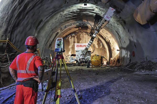
By Wim van Wegen, GIM International               feature

        Meanwhile, many companies are struggling
        to find a balance between productivity and
        employee well-being, as indicated by a
        manager from a survey company in the USA:
        “It has been hard to keep the crews on track
        and productive; we are all scared we may
        be causing harm by being exposed and then
        taking the virus home with us.” Other effects
        being felt by geospatial professionals include
        longer stints away from home due to travel
        restrictions, quarantine both onshore and
        offshore, and uncertainty of contract work.

        Wide range of expectations
        While it can be difficult to remain optimistic
        during such challenging times, a positive
        mindset always helps. A considerable number
        of survey participants are doing their best
        to see the upside of the current temporary             Governments across the world are initiating major national infrastructure projects. (Image courtesy:
        lull in activity. As a geospatial consultant         Züblin Spezialtiefbau)
        from Bulgaria puts it: “We now have time
        to think about innovation. On the edge of
        crisis, throughout the history of humankind
        there have been a lot of good examples
        of innovations that change directions to
        success.” A consultant from South Africa
        takes a similar view: “COVID-19 has made
        me rethink and refocus my business.” A
        software developer from Ireland states that his
        company has used the opportunity to make a
        positive shift to new technology and smarter
        working. Likewise, a consultant from Canada
        has seen positive change at his company:
        “The circumstances favour changes and have
        pushed the adoption of new technologies.”
        These and other positive responses from the
        survey participants provide a ray of hope in
        the short term.

        Although a considerable number of
        respondents are only cautiously optimistic
        about the future and prefer to take a ‘wait-
        and-see’ approach, many other industry
        professionals seem to already be focusing on
        the brighter future that will follow when the
        pandemic is finally over. In fact, the mood             GIS is increasingly shifting towards apps on mobile devices which enable faster data capture and
        among some matches the same positive vibe            information processing.
        reflected in last year’s industry survey. This
        optimism is supported by the fact that various
        governments are initiating major national            infrastructure and research & development             the high number of cross-border initiatives to
        infrastructure projects, in effect investing their   projects. Although that initiative is not directly    monitor and contain the spread of the virus
        way out of the crisis rather than intensifying it    linked to the coronavirus pandemic, it                have further highlighted its importance. For
        by making cutbacks. For example, during the          nevertheless offers interesting opportunities         example, governments require highly detailed
        first wave of the pandemic the UK government         for mapping and surveying companies.                  maps to be able to organize the nationwide
        announced a multi-billion-pound road and                                                                   programmes. A survey consultant from
        railway investment plan to stimulate the             Worldwide need for geodata                            Indonesia experts this to drive the demand
        nation’s economic recovery. Meanwhile, in the        Geospatial data already forms the essential           for reliable geodata, creating excellent
        Netherlands, the government has launched a           information layer for many public services,           opportunities for companies specialized in
        €20 billion national growth fund to invest in        but the rapid spread of the pandemic and              data capture, processing and visualization.

                                                                                                                                           busi ness gui de 2 0 2 1 |   international | 9

08-09-10-11_industrysurvey.indd 9                                                                                                                                                 28-01-21 11:19
feature

        Moreover, the pandemic has put our
        industry firmly in the public eye. Hence, one                      UAS for Mapping and 3D Modelling                                             40.3%
                                                                    1
        US-based surveying manager involved in
        the autonomous driving business foresees a
        post-pandemic realization of how important                         GNSS Receivers                                                               40.0%
                                                                    2
        spatial data is for various other markets and
        industries. A geomatics academic draws the
        same conclusion, commenting: “There are so
                                                                           Total Stations                                                               25.4%
                                                                    3
        many challenges facing different parts of the
        world which can be solved by our profession,
                                                                           Terrestrial Laser Scanners                                                   23.2%
        thus presenting opportunities to show our                   4
        relevance and importance.”

                                                                           Mobile Mappers                                                               22.7%
        Digitalization will play an important role                  5
        in helping the industry to make the most
        of the brighter future that lies ahead, as a               In what type of hardware systems do organizations plan to invest in 2021?
        surveyor from Canada points out: “Once the
        pandemic is over and there is a return to near
        normal, I believe the industry will continue            year’s industry survey reveals, such solutions       MoBile connectiVitY
        to grow through the increasing adoption of              are high up on the wish list of a significant        According to the respondents, mobile
        technology.” A researcher from Croatia sees             number of mapping and survey companies.              connectivity is another of the technological
        the current circumstances as fuelling new                                                                    developments having the greatest impact
        initiatives and opportunities: “The pandemic            It is a relatively small step from autonomous        on today’s surveying profession. Several
        has shown that spatial information is essential         vehicles to robots. There are already examples       professionals point out that GIS as an end
        for so many human activities. The ongoing               of robots being used in construction and             product is increasingly shifting towards apps
        development of technology and new concepts              mining, among other applications, as part of         on mobile devices which enable faster data
        (digital twins) will boost development and              a complete surveying workflow or an as-built         capture and information processing. Needless
        business.” A researcher from Malaysia agrees:           reality-capture workflow with a high degree          to say, the key benefit of app-based mobile
        “I expect that the integration of BIM and               of autonomy. Therefore, the robotization             mapping is convenience; such solutions
        surveying applications will mature.”                    trend is generally expected to accelerate. Not       support easier and more user-friendly
                                                                everyone sees this as a positive development,        surveying, especially in hard-to-reach areas
        roBotics                                                however. An academic from Malawi makes               and when accuracy demands are not too
        The survey confirms that developments                   the following prediction: “Surveying will            high. “Mobile is king for getting geospatial
        in the field of autonomous systems are                  increasingly be controlled by robots. One day,       into the hands of users,” states a New
        expected to continue to drive progress in               a person will only be required for verification,     Zealand government official, summarizing
        scanning technologies, including processing.            and eventually verification will be done by          the popularity of such apps. However, a
        For example, the miniaturization trend in               robots too. With machine learning/artificial         surveying manager from the United Arab
        advanced sensor technology means that                   intelligence/computer vision coupled with            Emirates sees this as posing a potential threat
        high-performance scanning equipment is                  robotics, the number of workers in the               to the reputation of the profession: “Although
        getting smaller all the time, which is opening          companies will greatly reduce. The money will        the technologies will get better, the quality
        up new applications related to autonomous               be invested in buying equipment rather than          of the end products will deteriorate since
        vehicles and mobile mapping systems. As this            paying salaries.”                                    more and more individuals without solid
                                                                                                                     technical/theoretical surveying background
                                                                                                                     will get involved (for cost-saving reasons)
                     GIS Software                                                                    41.9%           by the decision-makers who don’t possess
             1
                                                                                                                     the technical knowledge to properly support
                                                                                                                     decision-making on these issues.” On the
                     Point Cloud Processing Software                                                 38.0%           upside, a Belgian respondent working for
             2
                                                                                                                     a large manufacturer of survey equipment
                                                                                                                     and software states: “I see parallels with the
                     Photogrammetric Imagery Processing Software                                     34.4%           iPhone… the iPhone hardware gets better, but
             3
                                                                                                                     it is the app ecosystem that drives adoption
                                                                                                                     and value-add. We will see the same in
                     CAD Software                                                                    25.5%
             4                                                                                                       surveying. The ever-improving sensors will
                                                                                                                     bring new applications.”

                     Remote Sensing Imagery Processing Software                                      22.9%
             5                                                                                                       artificial intelligence
                                                                                                                     A survey company manager from Romania
             In what type of software do organizations plan to invest in 2021?                                       sees a strong connection between the rise

     10 |        international | business guide 2021

08-09-10-11_industrysurvey.indd 10                                                                                                                                     28-01-21 11:19
of mobile devices and artificial intelligence indispensable tools. On the software side, positive about the longer term: “Geospatial
(AI): “More and more on-board artificial the top-ranking purchases lined up for technology is being recognized as an efficient,
intelligence is embedded in these devices 2021 are GIS software, photogrammetric accurate and cost-effective technology by
and the 5G technology will allow them to imagery processing software and point-cloud administrators, planners and decision-makers,
collect and process files data and provide the processing software. so we can expect its use to increase.”
basic deliverables from the field.” Judging
by the frequency with which AI is mentioned While many companies still intend to invest in While there is no denying that the COVID-19
in this year’s survey, many others agree with new survey equipment and software systems pandemic is currently creating economic
him that this is an important development in this year, some of them have understandably headwinds for many of us, we can conclude
the surveying profession. “The automated put their purchasing plans on hold due to that the outlook for the geospatial industry
processing of collected data simply offers the economic impact of COVID-19. This has remains very promising.
so many opportunities,” observes one somewhat hampered the preparedness to
professional from the Netherlands. In a invest compared with a year ago. However,
broader software and IT context, several based on the respondents’ feedback in the
respondents believe that the innovations made survey, it is likely that the situation will return
in software for mass data processing will lead to pre-COVID-19 levels once the economy has
to large-scale adoption of photogrammetric bounced back.
and remote sensing processes. Again, AI ABOUT THE AUTHOR
plays a key role here. conclusion Wim van Wegen is head of content
The overall industry mood can perhaps of GIM International. in his role, he is
groWtH opportunities and inVestMent best be illustrated by a consultant from responsible for the print and online
In terms of hardware trends and investment Nepal who, despite having lost his job due publications of one of the world’s
plans for 2021, the respondents’ answers to the economic effects of the coronavirus leading geomatics trade media
indicate that many organizations are keen to pandemic, nevertheless remains optimistic: brands. He is also a contributor of
invest in mobile mapping systems, whether as “A geospatial component is being added columns and feature articles, and often interviews
unmanned aerial vehicles (UAVs or ‘drones’) to every part of technology. So there is renowned experts in the geospatial industry. Van Wegen
or ground-based systems. Total stations – increasing usage in a variety of fields beyond has a bachelor degree in european studies from the nHl
the surveyor’s workhorse – and GNSS just disaster management and infrastructure. university of applied sciences in leeuwarden, the
receivers are also part of many investment Hence, I strongly believe that future is very netherlands.
plans, so it seems that these classics remain geospatial.” A researcher from India is likewise
busi ness gui de 2 0 2 1 | international | 11
08-09-10-11_industrysurvey.indd 11 28-01-21 11:19RIEGL
Innovation in 3D
Laser Scanning Sensors & Systems
for UAS/UAV, terrestrial, mobile, airborne,
and industrial surveying applications
Stay connected with RIEGL
www.riegl.com
Austria | USA | Japan | China | RIEGL WORLDWIDE | Australia | Canada | United Kingdom5 QUESTIONS TO...
5 Questions to... Hansjörg Kutterer, DVW
Innovative developments based on data infrastructures, for example. Moreover, highly appreciated. Crowdsourcing offers
quantum physics will lead to further advanced data processing is required the opportunity to collect data that is
disruption of our professional field over which comprises things like deep learning either outside the scope of public agencies
the coming decade, predicts Hansjörg techniques. I also expect that innovative or could offer an alternative to existing
Kutterer who, besides being president of developments based on quantum physics administrative data that is only available
DVW, is also a professor of geodetic Earth will lead to further disruption of our with a licence. The DVW organization
system science. GIM International asked professional field over the coming decade. encourages any initiative that advances the
him five questions relating to the Quantum sensors such as optical clocks fields of geodesy, geoinformation and land
challenges and opportunities in the will provide accurate height differences management.
geospatial industry, now and in the future. over large distances, and quantum
computers will further speed up time- In terms of meeting your goals, what is the
2020 was an extraordinary year. How has the consuming computations. biggest challenge for your organization in
COVID-19 pandemic changed the way the the next five years?
industry operates, and which other factors Is the surveying profession able to attract As a university professor I am very aware
are influencing the geospatial business? enough qualified personnel? of the increasing need of the professional
The pandemic was and is extremely The number of qualified personnel is community for enhanced capabilities in
influential on our professional life. At becoming increasingly crucial for the further the digital transformation, in smart and
very short notice, we had to considerably development of the surveying profession. integrated systems, in the widespread
change our approaches from on-site and Despite the broad appeal of our professional application of our contributions, and in
immediate to remote and fully virtual field and the high number of vacancies, interdisciplinary work. This needs to be
settings. Fortunately, we could benefit there is still a lack of public visibility and further implemented in the curricula over
from the ongoing digital transformation. thus limited awareness among potential the coming years, including effective digital
The existing digital infrastructure and candidates. For this reason, there have settings and dedicated competence-
established procedures based on digital been various activities in Germany over oriented techniques. Actually, this is also
communication and collaboration tools the years aimed at reaching and attracting linked to DVW’s activities, albeit from the
could be used in order to overcome more young people to the industry. perspective of a non-profit organization.
obstacles caused by the pandemic. Thus, it For example, the Instagram campaign As DVW, we offer professional expertise,
was possible to provide effective substitutes #weltvermesserer has been launched in conferences, post-graduate training, highly
in the given situation, such as digital 2021 by a consortium consisting of all skilled working groups, and – last but not
meetings, digital conferences or digital national stakeholders, including the private least – an attractive networking platform
teaching. Nevertheless, both technical sector, administration, science and all for our members, essentially based on
capacities and personal capabilities relevant professional organizations. Both volunteering. This needs to be sustainably
needed rapid upgrades. Actually, the the expected impact of this campaign and maintained and further developed.
accelerated digitalization is both an the increasing interdisciplinary nature of our
opportunity and an obligation for the professional community will provide a good
geospatial business, as work can generally basis for tackling this sizeable challenge Hansjörg Kutterer has been
be continued on a digital basis but very successfully. president of the German Society for
often relies on digital geospatial data. Geodesy, Geoinformation and Land
What is your policy on crowdsourcing and Management (DVW) since 2016. He
Which new technologies do you foresee open data? has strong expertise and long-term
becoming important to your work? Due to my academic role and my volunteer high-level experience in various
This is going to be the decade of position within DVW, my answer is fields of geodesy and geo-
continuous Earth observation based on twofold. Open data policies are mandatory information, both in academia and
a sustainably maintained infrastructure for a more comprehensive scientific, administration. Since 2018, he has
and a comprehensive open-data policy. administrative or private exploitation of been a university professor of
The European Copernicus system may existing and newly incoming data. This geodetic Earth system science at
serve as an example. Rapidly increasing definitely refers to all stakeholders who Karlsruhe Institute of Technology
amounts of heterogeneous geospatial data rely on geospatial data. Data generated (KIT). Prior to that, one of his roles
are obtained within very short time spans. and used in science and education must was as director general of the
These new opportunities are accompanied be open and available through efficient German Federal Agency for
by the strong need for effective data digital data infrastructures. Sustainable Cartography and Geodesy (BKG).
management using integrated research open-data initiatives and programmes are
BUSI NESS GUI DE 2 0 2 1 | INTERNATIONAL | 13
13_qa.indd 13 28-01-21 11:38WHAT WILL SHAPE THE GEOSPATIAL INDUSTRY?
Emerging from
COVID-19
The geospatial industry has been more fortunate than others – such as hospitality and tourism – during the
COVID-19 pandemic. In fact, there are some exciting opportunities relating to accelerating the digital
transformation so that businesses can adapt to the ‘new normal’, as well as economic stimulus packages with a
greater emphasis on green growth. Furthermore, the health sector, which has long failed to exploit the
potential of geospatial, has started to recognize its value. This article examines these and other influences
that are likely to shape the future of the geospatial industry.
The COVID-19 pandemic has provided a look to the Far East. Countries such as South can we not trust our legislators to put in
warning about the very real risk of new crises Korea enacted legislation allowing government place such temporary measures for health
of an unforeseen nature emerging in the use of data from smartphones, social media emergencies?
future. At a time when healthcare systems are and ride-sharing apps to help understand and
under unprecedented pressure, geospatial control the spread of infection. Experience Digital tranSforMation
solutions have proved essential in crisis with SARS and, more recently, MERS led The most profound long-term change is
management by supporting analysis of how to democratic governments in the region likely to be the acceleration of the digital
the virus is being spread and by whom, as overcoming privacy concerns and enacting transformation, not only as underpinned
well as logistical challenges such as where laws to authorize emergency use of such data by European Union declarations, but
personal protective equipment (PPE) is being for public health purposes. In the West, we recognized globally. The rise of Zoom seems
manufactured and what supply chain is already trust our governments to collect and to have made companies more accepting of
required to get it to where it is needed. use – in strictly protected ways – vast amounts remote working almost overnight, resulting
of our personal data during population in a significant structural impact on the
perSonal privaCY vS puBliC HealtH censuses. The way they anonymize such configuration of cities and public transport
As various public inquiries look at what their data is well established and effective. So why, networks. The increasingly pervasive use of
own nations could have done better, they will in the developed democracies of Europe, the term ‘artificial intelligence’ (AI) to underpin
all use of advanced software engineering,
whilst a troubling misappropriation of the
term, does point to where geospatial can
contribute to adapting to such change. An
increasing interest in geoAI in the finance
sector, for instance, will be part of a move
to make better use of alternative sources of
data for ‘decisioning’ on investment options.
Another facet of digital transformation will
be the increased use of drones. Surveyors
may not be allowed to visit sites to undertake
their work and crews cannot travel to a site
together, but sending up a drone is OK. With
less air traffic, aerial surveys around the
busiest airports have also become easier.
SoCial anD eConoMiC DaMage
As the world emerges from the pandemic, the
Figure 1: Three-year forward growth by sector. (Source: ConsultingWhere) huge social and economic costs will start to
14 | international | business guide 2021
14-15-16_covid19.indd 14 28-01-21 11:19By Andrew Coote, ConsultingWhere feature
hit individual businesses and their employees. construction projects because of changes Earth observation data. Alongside this, the
It has clearly been necessary for governments to living patterns. People’s desire for more implementation of the global Financial Action
to substantially increase sovereign debt for outside living space will see the depopulation Task Force (FATF) recommendations will
job retention and other business support of cities over the next decade and the rise mean financial institutions will have to report
schemes, but that money will have to be paid of smaller developments in satellite towns. on climate-related risks as part of the stress
back. Interest rates are currently low and the The office-space needs will change for most tests imposed by regulators. In general, there
repayment periods for strong economies are geospatial companies due to the shift towards is currently a relatively poor understanding
relatively long. However, the danger is that the ‘WeWork’ model to preserve community of the location of the assets invested in by
inflationary pressures will grow as suppliers spirit and as face-to-face meetings are financial institutions. This will need to improve
rack up prices to recover losses suffered held less frequently and closer to home. to meet these requirements. The Spatial
during the pandemic. This change will be accompanied by the Finance Initiative is a good source of further
conversion of large swathes of office space for information on this potentially huge market for
Recent announcements of pay freezes for residential or other uses. geospatial companies. It will require complex
public-sector workers are a foretaste of cuts integration of Earth observation and human
in public investment and tax rises. With Silver linings geography (statistics, mobility, address)
public-sector organizations accounting for Nevertheless, the clouds hanging over the and the application of machine learning to
an estimated 50% of supply-side geospatial infrastructure sector have a silver lining. The huge quantities of data. ConsultingWhere
companies’ sales, this will affect revenues. For European Union Green Deal will drive massive is currently authoring a joint report with the
instance, there will probably be a slowdown investment in projects that have a positive Satellite Application Catapult on this subject
in digital twin projects, which are often environmental profile. This is not only good for due for release in early 2021.
sponsored by city authorities, as discretionary the planet, but is also likely to stimulate the
spending is cut with the diversion of resources need for wide-ranging environmental impact Market opinion
to social care. The situation is likely to be assessments. The greening of agriculture In the summer of 2020, ConsultingWhere
exacerbated by a reduction in new, large will create the need for ever-more precise conducted an opinion survey to test sentiment
busi ness gui de 2 0 2 1 | international | 15
14-15-16_covid19.indd 15 28-01-21 11:19in the industry on prospects over the next
few years. The respondents were mostly
UK-based and represented about 100
separate organizations with a reasonably
even spread, from small and medium-sized
enterprises (SMEs) to large multinationals.
This was the third in a series of surveys
and revealed some interesting results.
COVID-19 is currently having a significant
impact on the markets in which the
respondents operate. Only 33% expected
revenue growth in 2020, compared to 47%
expecting their revenues to grow in 2021
and 70% in 2022. In the pre-COVID-19
survey in early 2020, 62% were expecting
substantive growth over each of the following
three years. Figure 2: Changes in predicted growth between 2017 and mid-2020. (Source: ConsultingWhere)
SeCtoral ContraStS
Based on the survey, there has also been energy, transport and telecoms all show out of their comfort zone to engage customers
a sharp change in the patterns of expected that growth levels have been cut from their in new sectors and exploit the wide range of
growth by sector. The survey indicates that pre-COVID-19 levels but by much less than new technological advances coming out of the
more stable private sectors such as energy, their more cyclical counterparts. Each expects research community. If the industry does not
telecoms and water are still expected to to remain positive in terms of overall market adapt quickly, for sure others will move in to
expand, as are central government, health opportunity. Even within this seemingly ‘eat our lunch’.
and emergency services. On the other homogenous grouping, there are subtle
hand, sectors which are typically more differences in the underlying responses.
sensitive to consumer behaviour are More respondents indicated that growth in
expected to contract – particularly retail but transport was likely to be greater than 10%,
also construction, property and consumer better than in any of the other three sectors. FURTHER READING
mapping. Figure 1 summarizes the findings, This may reflect the potential for increased https://ec.europa.eu/isa2/news/eu-member-states-
organized from left to right in increasing geospatial involvement in the growing sign-berlin-declaration-digital-society_en
confidence in future growth. Sectors with market of delivery and collection businesses https://www.fatf-gafi.org/
relatively high sensitivity to consumer resulting from the move towards online https://spatialfinanceinitiative.com/
behaviour predominate on the left of the shopping. www.consultingwhere.com/lms20/
chart, whilst those markets with lower reliance
on consumer disposable incomes are shown puBliC SeCtor
on the right. Only the health sector has a higher average
growth rate post-COVID-19 than before it. ABOUT THE AUTHOR
tiMeline CoMpariSon The central government sector has held onto andrew Coote is principal
When the three recent surveys are viewed some of the gains that had been accrued consultant for ConsultingWhere. He
together, signs of the disruption to the upward since 2017 but is down on the pre-COVID-19 has over 30 years’ experience in the
trend in confidence become more clearly expected growth rate. This is likely to reflect development and use of information
visible. Figure 2 compares the average similar factors as healthcare in terms of systems, specializing in the
expected growth rate by sector across the increased focus on well-being outcomes. management of location-enabled
three surveys. In the 2017 survey, only two Pessimism on local government expenditure applications. He has held senior management positions
sectors were expected to contract – central endures. in both the public and private sector in the uK and
government and local government – whereas africa. His expertise lies in strategy development and
a broad array of sectors are now expecting ConCluSion implementation, return on investment and market
to suffer reduced demand over the next In summary, it is likely that the geospatial assessment. recent strategic assignments have taken
three years, some of which had high growth industry will prosper from the changes – both him to east asia, eastern europe, southern africa,
expectations in 2020. temporary and permanent – that are occurring australasia, north and south america and the Middle
as the world emerges from the pandemic. To east for customers including the World bank, european
private SeCtor use the current jargon, many businesses will union, esri, land information new Zealand and
This data throws new light on the prospects need to ‘pivot’ their business models to focus ordnance survey.
for the more stable private sectors. Water, on different sectors. This will involve moving
16 | international | business guide 2021
14-15-16_covid19.indd 16 28-01-21 11:19By VANESSA LAWRENCE feature
The Future of Geospatial:
Are We Everyone’s
Friend or Do They Not
Know We Exist?
The perspective the author brings to the ‘future of geospatial’ is taken from spending the last five years
assisting senior government officials from both developing and developed countries and also briefing senior
members of board rooms of some of the largest organizations in the world. They have all wished to think
through how the added dimension of location could make a difference to their decision-making.
Whilst we in the sector use terms such as to tackling emergencies. We covered its role information is now seen as a vital part of
‘geospatial information’, ‘our geospatial in industries, including construction, the a national and organizational information
community’ or even ‘the GIS team’, most property market, utilities, insurance, defence infrastructure.
senior government officials and senior and security, navigation, waste and asset
directors of organizations do not normally management, and logistics. Our discussion Fitting in
recognise these terms. They are looking at turned to its use at global scale, to assist So where do we fit in the future? Firstly, we
either enhancing the information infrastructure understanding and to tackle some of the know geospatial is an economic contributor.
of their country or their organization, or they biggest issues facing the globe: environmental The geospatial industry globally was valued
are looking at the competitive advantage to issues such as climate change, food security, at £300bn by GeoBuis Report (2019).
be gained from using extra data sources that identifying poverty and inequality and According to recent economic research, an
other competing organizations have not yet underpinning the measuring and monitoring economic uplift can be expected to occur
discovered. of United Nations Sustainable Development by organising geospatial information within a
Goals (SDGs). national spatial data infrastructure (NSDI) or
The boundaries between ‘geospatial’ and so a similar infrastructure. In a study undertaken
many other disciplines, in most users’ minds, By the end of the conversation, the phrase by the Boston Consulting Group (BCG) and
are simply non-existent. We too may need to that I first used when writing for GIS Europe a report by the UK Geospatial Commission
break down these boundaries more than we magazine in 1993 – ‘everything happens (2018), it was estimated that the fiscal
have done to date, in order to attract interest somewhere’ – was ringing in his head together uplift could total up to £14bn for the United
in what we do. And not just in the boardroom; with the understanding that geospatial Kingdom alone.
young graduates around the globe are flocking
to data science and space roles, but are
they equally attracted to geospatial? The
answer currently is ‘no’ as so many still do not
understand the power of our work and the
benefit to society it can bring.
Everything happens somewhere
Talking to a professor of data science
who ‘zoomed’ me recently, he had little
knowledge of geospatial, let alone that it
underpinned some of the biggest decisions
taken each day. We discussed its use in
government and their operations from Figure 1. The changing symbiotic relationship of the geospatial, space and AI industries over time.
managing resources, administering services, (Image Courtesy: Location International Ltd 2020.)
busi ness gui de 2 0 2 1 | international | 17
17-18-19_thefuturevanessa.indd 17 28-01-21 11:20calculations can be made per second,
assisting the terabytes of data within any
locational data stack to be easily analysed –
and consistent results to be provided to the
decision-maker.
It can therefore be concluded that the
geospatial community, the space community
and the AI community have a symbiotic,
mutually reinforcing relationship. Geospatial
information provides the context to the work
of the space and the AI industry and hence I
predict the geospatial community will grow in
importance as the benefits it brings to space
and AI is increasingly recognised.
Geospatial information in a digital
Figure 2: The Seraphim Capital Small Satellite Constellation Map. (Image Courtesy: Seraphim Capital society
2020) The UK Geospatial Commission (2020) stated
In ‘Unlocking The Power of Location: the UK’s
Geospatial Strategy 2020 to 2025’ that “by
We also know that we overlap considerably remote sensing community. But irrespective 2025, the UK will have a coherent national
with the space industry as well as the data of how versatile these platforms are, they location data framework underpinning a
science and AI industry (Figure 1). Each year, generally still only generate data that is not ‘in flourishing digital society” which highlights
we become more beneficial to them as the context’. the importance of geospatial information to
interoperability and open systems approach a country; and many similar statements are
around the globe is being increasingly It is only the combination of their outputs with referenced around the globe. Drawing on the
adopted across our industry. multiple other pieces of locational information recognition of this importance, together with
from ‘other providers’ which makes the space- the symbiotic relationship with other growth
The space industry is seeing significant based data become useful information for the sectors and the fact that ‘everything happens
growth in the Earth observation sector often decision-maker. These ‘other providers’ may, somewhere’ is vital to solving some of the
backed by venture capital investment (Figure at one end of the spectrum, be humans using globe’s biggest challenges. It is therefore
2). The ever-increasing number of and the their mobile phones in a passive locational necessary to consider how our community
move to smaller sized-satellites, downloading sense or, at the other end, highly accurate, should evolve for it to prosper – and not be
not only traditional bandwidths but now also authoritative geospatial data from either a subsumed into adjoining communities.
small-sat radar and video imagery together government or the private sector.
with the introduction of high-altitude platforms Clearly, aligning ourselves with our
(HAPs) that not only use solar energy but With the addition of AI algorithms to geospatial neighbouring communities will ensure that
now also hydrogen fuel, is revolutionizing the decision-making processes, millions of we are recognised for the benefits we can
bring. But there are many questions that
need to be answered for us to be successful.
These include such questions as: Should we
promote our role more within the measuring
and monitoring of the globe’s grand challenges
so that we are an attractive community to
join? Should we consider perhaps using not
only ‘geospatial professional’ but also ‘geodata
scientist’ within our vocabulary? Should our
graduate courses have greater intensity of
focus on computer science than they do
today? Should we simplify our messages,
so more people understand that ‘geospatial’
underpins everyone’s daily lives?
Over the past 10 years, geospatial has been
successfully used to tackle serious decisions
in many industries from manufacturing to
Figure 3: The future focus of those working in geospatial measured by relative importance. (Image the finance markets and, of course, more
Courtesy: Location International Ltd 2020.) recently, underpinning much of the analysis
18 | international | business guide 2021
17-18-19_thefuturevanessa.indd 18 28-01-21 11:20FEatUrE
undertaken in the COVID-19 pandemic. With a subject area measuring and monitoring
However, the awareness of the impact the biggest issues facing the globe which is
geospatial makes has always been similar to no longer hampered by being ‘technology led’,
‘Intel inside’ our computers but without even a that already adopts international protocols and
label to identify ourselves! This has to change standards and is needed by adjacent growth
for our identity not to be lost to other subject industries, it is clear that the community will
areas. continue to thrive.
Due to our historical roots, technology has However, our success is conditional on us
often been the lead focus for the geospatial all being able to express and rationalise what
community. Today, we need to ensure that the we do, why we do it, for whom we do it and
focus is changed to one that emphasises the how we do it. This has to be in language that ABOUT THE AUTHOR
impact we can have organizationally, using everyone understands and is simple to grasp, dr vanessa lawrence Cb FriCs is
globally adopted standards and ensuring our starting perhaps always with the phrase that working internationally as a senior
people have the skills to meet the growth of is now 27 years old, ‘everything happens advisor to governments, inter-
geospatial, as more data becomes available somewhere’. governmental organizations
from so many sources (Figure 3). including the World bank and large
private-sector organizations. she is a
non-executive director of several major scientific
FURTHER READING organizations in the uK and abroad. From 2000-2014,
- geobuis report (2019), https://geoguiz.com/geobuiz-report-2019. she was the director general and Ceo of ordnance
- uK geospatial Commission (2018), https://www.gov.uk/government/publications/ survey, britain’s national mapping authority and from
geospatial-commisssion-annual-plan-2019-2020. 2011-2015, she was a founding co-chair of the united
- uK geospatial Commission (2020), unlocking the power of location: the uK’s geospatial nations Committee of experts on global geospatial
strategy 2020 to 2025. information Management (un-ggiM).
busi ness gui de 2 0 2 1 | international | 19
17-18-19_thefuturevanessa.indd 19 28-01-21 11:20You can also read