East Coast Life at the Boundary - Living, learning and thriving - Resilience to Natures Challenges
←
→
Page content transcription
If your browser does not render page correctly, please read the page content below
East Coast
Life at the Boundary
   - Living, learning and thriving -

  Resilience to Natures Challenges
     Natural Hazard Research Forum
                  2019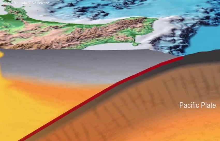
Our partners

•   Hawke’s Bay Civil Defence Emergency            •   Massey University
    Management Group/Hawke’s Bay Regional          •   Earthquake Commission (EQC)
    Council                                        •   Ministry of Civil Defence & Emergency
•   Tairāwhiti Civil Defence Emergency                 Management
    Management Group/Gisborne District             •   Greater Wellington Regional
    Council                                            Council/Wellington Region Emergency
•   Natural Hazard Research Platform/ Resilience       Management Office
    to Nature’s Challenges                         •   Manawatu/Wanganui CDEM Group
•   GNS Science                                    •   National Aquarium of New Zealand
•   National Institute of Water and Atmospheric •      University of Auckland
    Research (NIWA)                                •   Quake CoRE
Our programme

•    Makes it easy & exciting to learn more about natural hazards and how
     they affect us living on the East Coast
•    Supports & shares scientific research focusing on hazards associated with
     the Hikurangi subduction zone and living at the coast

•    Covers four regions – Gisborne, Hawke’s Bay, Tararua &
     Wairarapa/Wellington
Why do we do it?

        He aha te mea nui o te ao.
    He tāngata, he tāngata, he tāngata
     What is the most important thing in the world?
          It is people, it is people, it is people.
Education &                        Risk
                              Research
                                                          engagement                      reduction

Note: These are only
examples of some of the      Hikurangi subduction earthquakes and slow slip behavious: GNS led MBIE funded

projects that are carried               Kura e tai āniwhaniwha: Massey led Quake CoRE funded
out through the East Coast
LAB programme.                         Quicker, safer tsunami evacautions: GNS led NHRP funded

For more information                Participatory technology for citizen science: AUT led RNC funded
check out our website:
                                        Hikurangi response planning: ECLAB led MCDEM funded
www.eastcoastlab.org.nz
What do we rely on?
Your support & willingness to:
• Ask for advice
• Carry out relevant research
eg. co-created research outcomes
• Share your research
• Help fund usResilience to Natures Challenges
Natural Hazard Research Forum
2019The Project
The Project
                                        2018/2019   2019/2020   2020/2021

                Bay of Plenty CDEM

                  Tairāwhiti CDEM

                 Hawke’s Bay CDEM
              Manawatu-Whanganui CDEM
              Wellington CDEM
              MCDEM
Our journey and why we use science
GNS Science credible
Hazard Workshop Stakeholder Workshops Response Planning
scenario
2018 2019 2019
2018
RiskScape data
• National Disaster Resilience Strategy- Objective 1: Understand risk scenarios
• Science informs impact which enables emergency planners to plan for
consequences
• Science helps to justify response planning and funding by highlighting risk and
why investment in risk reduction activities is so importantWhat science do we use
1. Science scenario: Credible magnitude 8.9 earthquake and tsunami
• Incl. qualitative impact assessments (expert panel approach)
2. RiskScape modelling
• Uses GNS Science scenario (for impact), and
• Tsunami evacuation maps (for exposure)
3. Social science research
• To inform our work e.g. risk communication workshop
…but, we also help to create research-
• HRP is being researched to inform risk communication understandings eg. Survey of
our introductory project videoWhat works/learnings/future opportunities
1. Science scenario: Credible magnitude 8.9 earthquake and tsunami
• Scenario very engaging for all stakeholders- impact maps showing tsunami
inundation and earthquake MMI’s ost useful
• Showing inundation at NZ scale useful to avoid disengagement if
stakeholders determine assets ‘safe’
• Use tsunami evacuation zones more at regional scales to demonstrate
that it is one scenario of many
• Multiple models showing variations in output beneficial to show how
impacts can change and that just one scenario of manyWhat works/learnings/future opportunities
2. RiskScape modelling
• RiskScape numbers useful to further understanding of impacts and grab
attention
• Definitive/absolute numbers based on one scenario can narrow focus
• Presentation of data is important- maps of impact easier to digest by
stakeholders rather than tables (quickly attain situational awareness
• We need to continue to collaborate on model outputs
3. Social science research
• Social science helps inform us of human behaviour- great for use for
education, engagement and communicationRecommendations
• Communication of uncertainty is important
• Contextual visuals help to understand impact, one example of
bridging the gap between the scientist and ‘layman’
• Data has so much power to educate but it needs to be communicated
in the right way
• Keep communication lines open throughout science delivery
• Let’s continue to collaborate!Thank you For more information visit: eastcoastlab.org.nz/hikurangiresponseplan
You can also read