Empty' space in Central European medieval towns through an interdisciplinary perspective
←
→
Page content transcription
If your browser does not render page correctly, please read the page content below
Urban History (2020), 1–21
        doi:10.1017/S0963926820000760

        S U RV E Y A N D S P E C U L AT I O N

        ‘Empty’ space in Central European medieval
        towns through an interdisciplinary perspective
        Paweł Cembrzyński1*             and Maciej Radomski2†
        1
          Cluster of Excellence ROOTS, Christian-Albrechts-Universität zu Kiel, Leibnizstraße 3, 24118 Kiel,
        Germany
        2
          Institute of Archaeology and Ethnology PAS, Al. Solidarności 105, 00-140 Warsaw, Poland
        *Corresponding author. Email: pawelcembrzynski@op.pl

            Abstract
            Empty, abandoned or covered with vegetation – such areas were inherent to the medieval
            urban space, yet remain overlooked in research. Here, we describe three major types of
            ‘empty’ space of various origins and functions in Central European towns and suggest
            how these types can be investigated and interpreted through an interdisciplinary approach
            combining archaeological, written, pictorial and cartographical sources. We propose a
            simple interdisciplinary protocol to trace empty spaces in the urban context. This study
            will help to change our perception of medieval urban space into one that is more dynamic
            and heterogeneous than commonly believed.

        Introduction
        In 2008, the archaeologist M.L. Smith, looking from a global perspective, pointed
        out that pre-modern urban areas were never fully built up.1 She used the term
        empty space to describe areas created as zones in which construction was prohib-
        ited or which were the temporary and unintended result of destruction, clearance
        and abandonment. They might be permanently empty (like plazas) but might
        also be empty on a seasonal or temporary basis. These short-term empty spaces
        (in the order of years or decades) could be used as playing spaces, meeting grounds,
        squatter settlements or zones of economic value such as gardens. The issue
        of ‘empty’ space in Central and northern European towns has generally been
        overlooked due to the dominance of traditional images of the town, as an
            †
             This research was financed by the grant Fuga 5 (2016/20/S/HS3/00084) provided by the National
        Science Centre. We would like to thank Urszula Sowina, Tomasz Związek, Łukasz Miszk, Kamil Kopij,
        Radosław Gliński, Joanna Sudyka and Beata Możejko for their invaluable advice. We are also grateful to
        Małgorzata Chorowska, Tomasz Cymbalak and Armand Baeriswyl for permission to publish illustrations.
        We would like to thank both referees and the editor for valuable comments.
           1
            M.L. Smith, ‘Urban empty spaces. Contentious places for consensus-building’, Archaeological Dialogues,
        15 (2008), 216–31.
        © The Author(s), 2020. Published by Cambridge University Press. This is an Open Access article, distributed under the
        terms of the Creative Commons Attribution-NonCommercial-ShareAlike licence (http://creativecommons.org/licenses/
        by-nc-sa/4.0/), which permits non-commercial re-use, distribution, and reproduction in any medium, provided the
        same Creative Commons licence is included and the original work is properly cited. The written permission of
        Cambridge University Press must be obtained for commercial re-use.

Downloaded from https://www.cambridge.org/core. IP address: 46.4.80.155, on 17 Jul 2021 at 10:14:20, subject to the Cambridge Core terms of
use, available at https://www.cambridge.org/core/terms. https://doi.org/10.1017/S0963926820000760
2       Paweł Cembrzyński and Maciej Radomski

          urban-architectural complex enclosed by walls and fully developed both physically
          and conceptually, which has existed since the Middle Ages.2 Nevertheless, the
          problem of ‘empty’ space has been noticed and discussed by several authors.
          Important observations were made by J. Piekalski from an archaeological perspec-
          tive in his book about medieval urbanization in Central Europe.3 He emphasized
          that the urban fabric inside town boundaries was not created in a single action, but
          was developed slowly over time as vacant land was taken up for building purposes.
          Some of those undeveloped areas stayed empty for a long time. Such empty spaces
          could be found between older urban cores in polycentric towns or on the periph-
          eries of built-up areas around the market square and main streets in planned char-
          tered towns. Case-studies of peripheral intramural areas in Freiburg im Breisgau
          (Germany) and Bern (Switzerland) were provided by A. Baeriswyl.4 He noticed
          that peripheral areas were built up a few decades after the towns were established,
          while before that they belonged to communes or were used as private gardens. The
          reverse process, of urban decline, was described M. Untermann5 who emphasized
          that archaeologists do not concentrate enough on evidence of decline, which results
          in a lack of data for further analysis. He provided several examples of how a town
          could shrink and change functions of land by recreating urban layout or changing
          terrain into gardens. The issue of urban decline and contracting urban space in
          English towns was addressed in the volume Towns in Decline AD 100–1600, in
          which G. Astill drew attention to the importance of tracing abandonment in a larger
          spatial context, not limited to a single plot,6 while K.D. Lilley proposed tracking
          deserted land through urban morphology analysis. He also established why certain
          parts of towns became vacant, showing that it was not always a result of decline
          but of changes in the social and economic composition of urban centres.7
             In the light of this research, we identified a gap in the common understanding
          of medieval urban space – the un-built areas. We call these types of space ‘empty’
          to stress the contrast between them and the densely built-up zones of a medieval
          town. As these places were mostly peripheral, negligible and difficult to trace, they
          have not been studied as a separate research problem, which makes them ‘empty’
          also in terms of their historiographical treatment. They are, however, important
          for understanding the dynamic of changes and contemporary perceptions of
          urban space. In our survey, we introduce three categories of ‘empty’ space
          found inside towns’ physical boundaries: (1) emptiness (places without any traces
          of permanent utilization), (2) deserted/abandoned spaces and (3) green spaces
             2
              R. Eysymontt, ‘Zróżnicowanie form zagospodarowania przestrzeni w murach śląskiego miasta
          średniowiecznego. Konfrontacja źródeł pisanych i ikonograficznych’, Kwartalnik Historii Kultury Materialnej,
          63 (2015), 225.
             3
              J. Piekalski, Von Köln nach Krakau. Der topographische Wandel früher Städte (Bonn, 2001).
             4
              A. Baeriswyl, Stadt, Vorstadt und Stadterweiterung im Mittelalter. Archäologische und historische
          Studien zum Wachstum der drei Zähringerstädte Burgdorf, Bern und Freiburg im Breisgau (Basel, 2003).
             5
              M. Untermann, ‘Schrumpfungsprozesse in der spätmittelalterlichen Stadt’, in A. Lampen and A. Owzar
          (eds.), Schrumpfende Städte. Ein Phänomen zwischen Antike und Moderne (Cologne, Weimar and Vienna,
          2008), 91–107.
             6
              G. Astill, ‘Archaeology and the late-medieval urban decline’, in T.R. Slater (ed.), Towns in Decline AD
          100–1600 (Aldershot, 2000), 214–34.
             7
              K.D. Lilley, ‘Decline or decay? Urban landscapes in late-medieval England’, in Slater (ed.), Towns in
          Decline, 235–65.

Downloaded from https://www.cambridge.org/core. IP address: 46.4.80.155, on 17 Jul 2021 at 10:14:20, subject to the Cambridge Core terms of
use, available at https://www.cambridge.org/core/terms. https://doi.org/10.1017/S0963926820000760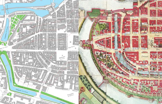
Urban History             3

        (areas covered with utility crops, such as gardens, fields, vineyards, etc.). We aim
        first to establish how the three categories of ‘empty’ space can be traced through
        an interdisciplinary approach based on combining different categories of histor-
        ical sources (material, written, pictorial), second to discuss the applicability of
        such an approach, third to discuss how the issue of ‘empty’ space should be
        addressed in urban studies and fourth how addressing it can change our view
        of medieval urban space.

        Chronological and geographical scope
        In order to achieve these aims and demonstrate the ubiquity of the phenomenon,
        we used examples from a period between the thirteenth and seventeenth centur-
        ies, studying towns of various sizes, in different locations and displaying varying
        degrees of urban culture from a region of Central Europe including today’s
        Germany, Poland and Czechia. Medieval urban centres in this region shared a
        common legal and spatial model, which emerged in the Holy Roman Empire
        and was subsequently transferred to the east to the kingdom of Bohemia,
        Pomerania, Silesia, Poland, Hungary and beyond.8 Their spatial organization
        was characterized by an urban layout divided into regular plots, which were
        grouped in blocks, with central market spaces and physical town boundaries,
        whether it was the regular urban grid of a Lokationsstadt or the more asymmet-
        rical structure found in older towns. Most of those towns developed in similar
        ecological conditions in a temperate climate, meaning that their interaction
        with the environment in terms of water supply, waste disposal, protection from
        weather conditions and access to resources would have been similar. Both the
        spatial layout and the environmental conditions would have been comparable,
        regardless of the size of the settlement, which means that the proposed method
        of studying ‘empty’ space can also be applied to smaller towns with a lower
        level of urbanization and a less-developed legal culture. We have also drawn add-
        itional examples from western and northern Europe. The extended chronological
        perspective is dictated by the long duration of spatial structures of medieval
        towns. Unlike Smith, we do not consider spaces like squares or streets, because
        although technically ‘empty’, they were planned as deliberate and permanent
        features of a town.

        Methods and sources
        ‘Empty’ space is an immanent, albeit elusive, part of the urban structure, which can
        be reconstructed using material, written, pictorial and cartographic sources, and
        by employing archaeological methodologies (including auxiliary disciplines such
        as archaeobotany and geoarchaeology), history and combined approaches such as
        urban morphology. The following section will characterize each method, and its
        advantages and disadvantages in reconstructing the urban structure.

          8
           E.g. Piekalski, Von Köln; R. Bartlett, The Making of Europe: Conquest, Colonization, and Cultural
        Change, 950–1350 (Princeton, 1993); K.D. Lilley, Urban Life in the Middle Ages 1000–1450 (New York,
        2002), 83–92.

Downloaded from https://www.cambridge.org/core. IP address: 46.4.80.155, on 17 Jul 2021 at 10:14:20, subject to the Cambridge Core terms of
use, available at https://www.cambridge.org/core/terms. https://doi.org/10.1017/S0963926820000760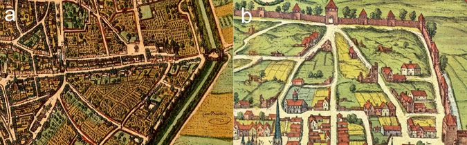
4        Paweł Cembrzyński and Maciej Radomski

          Archaeology
          Archaeology studies urban space through analysis of chronology and functions of
          material remains. The crucial issue is the precise reconstruction of a chronology.
          The relative chronology of a site is established from the stratigraphic relations
          between archaeological contexts (stratigraphic units) i.e. layers and structures.9 It
          can be developed into an absolute chronology by analysing chronological markers
          found in layers (e.g. coins providing a terminus post quem for the formation of
          a particular archaeological context)10 or by dendrochronological or radiocarbon
          dating.11 However, archaeologists often date stratigraphic units on the basis of a
          chronology derived from artefacts (pottery, stove tiles or small finds such as pieces
          of clothing, etc.) established during previous studies. Because of its near ubiquitous
          presence, pottery is most widely used. As its chronology is never very accurate, it
          gives information about the long time intervals in which it was used rather than
          specific dates.12 The chronology of an archaeological site might vary therefore
          from a very accurate sequence of changes to a broad idea about when things
          happened. Nevertheless, it is crucial for establishing how long a studied area was
          deserted or undeveloped. A functional reconstruction of urban space is based on
          tracing remaining constructions, analysing portable material culture found in
          their context, finding analogies from previous research and ethnography and
          performing specialist laboratory analysis (e.g. of slags in case of furnaces, craft
          by-products, etc.). The absence of any indication of activity in archaeological layers
          might suggest the presence of ‘empty’ space, but it is not conclusive evidence.
          Finding traces of agriculture and horticulture is important in identifying green
          spaces, which can be done by applying geoarchaeological and paleoenvironmental
          techniques to study the composition and structure of soil.13 Such microscopic
          analyses may completely change the understanding of stratigraphic sequences,
          and, therefore, the interpretation of urbanization processes. Unfortunately, they
          are rather rarely employed in urban excavations.

          Urban written sources and topographical reconstruction
          The majority of written sources used to study urban space were produced for or by
          municipal authorities. Their character and content depended on the administrative
          structure and organization of the town, which varied depending on time, location
          and the size of the town in question. Usually, the larger the town, the bigger and
          more specialized its administration was, and the spheres of urban life that it docu-
          mented were more diverse. Over time, urban archives (kept by civic officials) gath-
          ered various types of acts and deeds (charters, privileges, correspondence with other
          centres and central government), court and administrative records (criminal, trade
              9
              E.C. Harris, Principles of Archaeological Stratigraphy (London and New York, 1989).
              10
               B. Scholkmann, H. Kenzler and R. Schreg (eds.), Archäologie des Mittelalters und der Neuzeit.
          Grundwissen (Darmstadt, 2016), 96.
             11
               M. Carver, ‘Aims and methods. Part 1. Scopes and agenda’, in M. Carver and J. Klápště (eds.), The
          Archaeology of Medieval Europe, vol. II: Twelfth to Sixteenth Centuries (Aarhus, 2011), 15–48.
             12
               C. Orton and M. Hughes, Pottery in Archaeology, 2nd edn (Cambridge, 2013), 219–34.
             13
               R.I. Macphail and P. Goldberg, Applied Soils and Micromorphology in Archaeology (Cambridge, 2017),
          ch. 9.

Downloaded from https://www.cambridge.org/core. IP address: 46.4.80.155, on 17 Jul 2021 at 10:14:20, subject to the Cambridge Core terms of
use, available at https://www.cambridge.org/core/terms. https://doi.org/10.1017/S0963926820000760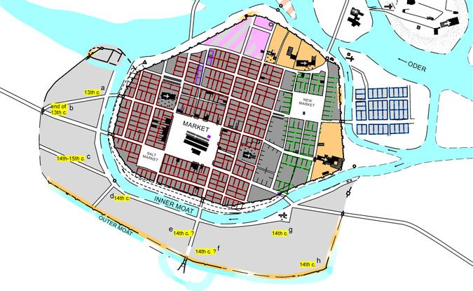
Urban History             5

        and property transactions, tax, building and development surveyors’ registers,
        accounts, wills, testaments and inventories, financial bills, ordinances, etc.).14
        Urban charters, registers of real-estate transactions, tax rolls and building surveys
        are especially useful for reconstructing urban space. With the exception of charters,
        they mostly consisted of short, formulaic notes written in Latin or vernacular
        languages.
            Most information about urban space found in municipal sources concerns single
        plots – the basic unit of both a town’s spatial structure and its governing and tax-
        ation systems. Establishing whether recorded plots were built up, undeveloped,
        abandoned or derelict might be crucial for distinguishing between the three cat-
        egories of ‘empty’ space. Therefore, it is necessary to identify the usage of the
        words commonly employed to describe urban plots. Analysis of this terminology
        shows the limited potential of written evidence, as the terms used had multiple
        meanings and were applied differently depending on a location, time, local admin-
        istrative traditions and even an individual clerk’s education and proficiency in Latin
        and vernacular languages. A plot might be described with one of the following
        nouns: curia, area, hereditas, domus, terra, fundus, hof, erbe.15 Town charters, pro-
        ducts of non-urban chanceries, written mainly in Latin most often used curia to
        mark plots given to burghers as a dwelling, ownership of which was associated
        with the possession of urban citizenship and was dependent upon the payment
        of annual rent. The term, therefore, encompassed a measured plot ready for devel-
        opment with all the buildings to be constructed on it in the future and all the bur-
        dens and privileges associated with it. In Bohemia area was used with the same
        meaning and in the same context as curia. Although the word curia was generally
        employed to denote a measured plot ready for development, in the same records it
        could also be used to denote a palace, a mansion or another kind of property
        belonging to noblemen or clergy, in or outside a town.16 Sometimes, especially
        in German towns, it also indicated a town hall (praetorium, Rathaus) or a royal,
        ducal palace. Nonetheless, it was used to mark space, which was, or at least should
        have been, built up. Vernacular terms used in urban records in much the same con-
        text as curia were hof and erbe. They both described a plot, which was the heredi-
        tary dwelling of burghers (connected with possessing urban citizenship). The first
        word is an exact German translation of curia, with all the variant meanings of the
        Latin one. The latter term literally means ‘inheritance’ (lt: hereditas). In Wrocław it
        was used in records of real-estate transactions. A plot referred to as an erbe was the
        basic unit in land exchange as it marked hereditary rights to a piece of land. It could
        also be leased to someone for building a house (hus, heus) – in that situation, the land
        and the house belonged to different owners.17 The erbe was also the basic unit in tax
        rolls of other Silesian urban centres. However, in land transaction records of Silesian
        towns the erbe was rarely applied; instead, the term hus (heus) – meaning a house –
        was much more common and was used to describe the whole property – both land
           14
            A. Bartoszewicz, Urban Literacy in Late Medieval Poland (Turnhout, 2018), 89–174.
            U. Sowina, ‘Średniowieczna działka miejska w świetle źródeł pisanych’, Kwartalnik Historii Kultury
           15

        Materialnej, 43 (1995), 323–31; M. Goliński, ‘Działka miejska w śląskich źródłach pisanych (XIII–XVI w.)’,
        Kwartalnik Historii Kultury Materialnej, 43 (1995), 333–42.
          16
            Sowina, ‘Średniowieczna działka’, 329.
          17
            Goliński, ‘Działka miejska’, 336.

Downloaded from https://www.cambridge.org/core. IP address: 46.4.80.155, on 17 Jul 2021 at 10:14:20, subject to the Cambridge Core terms of
use, available at https://www.cambridge.org/core/terms. https://doi.org/10.1017/S0963926820000760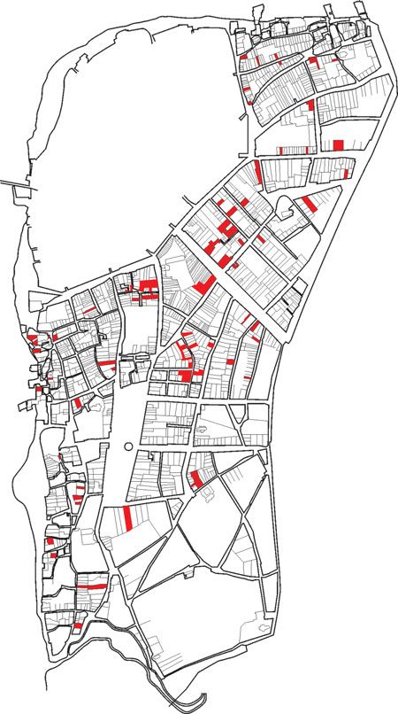
6        Paweł Cembrzyński and Maciej Radomski

          and buildings together.18 The same practice was widespread in the administrative
          records of Polish towns. There, the Latin word domus (house) often marked a
          built-up plot in real-estate transactions, encompassing both land and buildings.19
          The Latin term area (synonyms terra, fundus) was the most universal and had
          the broadest meaning.20 In all the regions of this study, it denoted a dwelling
          plot, although it could be used to mark both a measured building plot and one
          which was already built up.21 In the records of the small town of Kamionka
          (Poland), clerks described built-up dwelling plots with the term domus, while gen-
          erally reserving the word area for those which were empty or deserted.22 However,
          there were inconsistencies in usage. In one note, the same plot was named first as
          area and in the next sentence as domus.23 In the urban registers of Old Warsaw
          (Poland), its clerk used predominantly the term domus when the object of a prop-
          erty transaction was a built-up plot. Nevertheless, sometimes this clerk described
          the same type of property with the phrase domus et area (a house and a plot).24
          In a few cases, he also employed the phrase area cum edificiis (a plot with buildings
          on it),25 which probably meant that there were buildings other than a house on this
          particular plot. Therefore, these terms are useful in identifying actual empty areas
          only when some descriptive words were added, for example phrases such as area
          vacua, area vacans (an empty plot) seem to indicate plots with no buildings.
             Because of the variations in the terminology and its usage, it is not feasible to
          identify ‘empty’ space in towns without thorough analysis of the context and
          more importantly different types of evidence. The written sources can provide a
          starting point and help to identify areas of particular interest, which should then
          be compared and examined using archaeological data and techniques.

          Pictorial sources
          Pictorial sources, especially post-medieval town views, provide direct information
          about a town’s topography, the shape and form of buildings, the road networks,
          etc. The first realistic views and plans of towns started to appear in late medieval
          Italy.26 The sixteenth century brought the introduction of the bird’s-eye view,
          which depicted towns in a form something between a plan and a profile.
          Presenting distinctive spatial and material features of individual sites, these new
          images reveal a complex urban system of infill buildings, monuments, squares,

              18
               Ibid., 341.
               Sowina, ‘Średniowieczna działka’, 328–9.
              19
             20
               ‘ELexicon of the Polish medieval Latin’, http://scriptores.pl/elexicon/en/, accessed 15 Jul. 2019; ‘The
          dictionary of medieval Latin in Czech lands’, http://lb.ics.cas.cz/, accessed 15 Jul. 2019.
             21
               Sowina, ‘Średniowieczna działka’; Goliński, ‘Działka miejska’.
             22
               A. Sochacka and G. Jawor (eds.), Księga sądowa miasta Kamionki w ziemi lubelskiej 1481–1559
          (Lublin, 2009), nos. 57, 58.
             23
               Ibid., no. 78.
             24
               Archiwum Główne Akt Dawnych (AGAD), SW 529, fols. 54, 147v, 233.
             25
               AGAD, SW 529, fols. 172, 174v.
             26
               P.D.A. Harvey, ‘Local and regional cartography in medieval Europe’, in J.B. Harley and D. Woodward
          (eds.), The History of Cartography, vol. I: Cartography in Prehistoric, Ancient, and Medieval Europe and the
          Mediterranean (Chicago and London, 1987), 464–501.

Downloaded from https://www.cambridge.org/core. IP address: 46.4.80.155, on 17 Jul 2021 at 10:14:20, subject to the Cambridge Core terms of
use, available at https://www.cambridge.org/core/terms. https://doi.org/10.1017/S0963926820000760
Urban History             7

        roads, walls and various landscape features.27 Although renaissance depictions were
        often quite realistic, it is vital to remember that sometimes their authors intended to
        idealize or allegorize the represented world. Streets and squares shown on town
        views were often cleared of people, and shapes of buildings were changed to
        form a better composition.28 Town views might also have been instruments of
        propaganda sponsored by governments or commercial ventures, designed to pre-
        sent an urban centre in a particular way.29 Moreover, it is difficult to use them
        for tracing changes in a specific urban space as engraved plates were often re-used
        for years and old views became a source for new pictures.30
           Among the landscape features that were commonly depicted were gardens, fields
        and unbuilt-up areas, etc., which might provide evidence of existing ‘empty’ space
        or indicate where it might have occurred. Moreover, they also provide clues about
        how urban space was perceived at the time, suggesting that contemporaries did not
        necessarily view towns as homogeneous densely built-up areas.

        Urban morphology
        Urban morphology is a research method that identifies different types of urban
        landscapes through study of their morphological characteristics, formation and
        transformation of urban fabric and spatial patterns.31 It combines fieldwork and
        map analyses. Maps made by professional surveyors in the nineteenth century
        are one of the principal sources, as they were the first accurate plans to register
        structures existing before the changes of the industrial revolution and the twentieth
        century.32 The method, as Lilley summarized it,33 consists of four stages. The first is
        preparation of a town plan derived from the earliest most accurate map. The second
        stage is the process of plan analysis which involves defining ‘plan units’: plots and
        streets that share similar morphological character (size, shape, etc.). These units are
        the basis for further analysis of historical evidence. In the third stage, the historical
        material (archaeological structures, urban tax registers, etc.) is integrated into the
        town plan and is used to provide a relative chronology of topographical features.
        In stage four, the individual plan units and their morphological histories are all
        pieced together to create a map of the changing urban landscape. Retrospective
        analysis of available town plans (although these are not always accurate) can be
        applied to help establish the chronology of the changes.
           In the case of ‘empty’ space, urban morphology can help with tracing areas that
        were unoccupied (or covered with vegetation) for a long time and which continued

           27
             H. Ballon and D. Friedman, ‘Portraying the city in early modern Europe: measurement, representation,
        and planning’, in D. Woodward (ed.), The History of Cartography, vol. III: Cartography in the European
        Renaissance. Part 1 (Chicago and London, 2007), 680–7.
           28
             P. Burke, Eyewitnessing: The Uses of Images as Historical Evidence (London, 2001).
           29
             Ballon and Friedman, ‘Portraying the city’, 680–1.
           30
             Ibid., 691.
           31
             K.D. Lilley, ‘Urban morphology’, in B. Kitchin and N. Thrift (eds.), International Encyclopedia of
        Human Geography (Amsterdam, 2009), 66.
           32
             K.D. Lilley, ‘Mapping the medieval city: plan analysis and urban history’, Urban History, 27 (2014), 7–
        10.
           33
             Ibid., 12–14.

Downloaded from https://www.cambridge.org/core. IP address: 46.4.80.155, on 17 Jul 2021 at 10:14:20, subject to the Cambridge Core terms of
use, available at https://www.cambridge.org/core/terms. https://doi.org/10.1017/S0963926820000760
8 Paweł Cembrzyński and Maciej Radomski
to be visible much later in the urban layout. In contrast to densely built-up centres
with regular narrow plots, what was once ‘empty’ space manifests itself on modern
plans as areas with different street patterns, not necessarily regular, with larger
buildings, but also as land covered with vegetation, gardens and wastelands.
Emptiness
The first type of ‘empty’ space is emptiness: terrains that had never been built up
and for which there is no indication of any permanent human activity. This kind of
‘empty’ space was ephemeral and could quickly disappear, which makes it difficult
to trace. We assume that the emptiness was created when a new town was founded
in order to ensure a reserve of building land for future development. It can be iden-
tified through a large-scale urban morphology analysis and on a smaller scale
through circumstantial evidence.
Empty areas as building reserves
Piekalski assumed that empty areas occurred on the peripheries of built-up zones and
were treated as building reserves. Their existence has been observed in Central
European chartered towns, which were often founded on uninhabited land. The
nucleus of these towns, its communal and commercial centre, was a market square
(German Ring).34 According to the accepted model of urban development,35 the mar-
ket square was the first delimited element of a new regular urban layout, around which
the first burghers settled, while subsequent newcomers occupied main and later side
streets. Since the creation of a new town required a border to be established separating
the town’s area from outside,36 this was probably done at an early stage.37 As the town
gradually developed (assuming that not all the plots inside the boundaries were inhab-
ited when it was chartered), all unoccupied areas could be considered as empty. To
establish their extent and the dynamics of urban development, it is necessary to
trace the chronology of the oldest artefacts and structures in an urban area.
The gradual development of an urban layout is visible in Wrocław (Poland). On
a cadastral plan of the city made in 1902–12,38 we can distinguish differences in the
J. Piekalski, ‘Centrum średniowiecznego miasta jako problem badawczy archeologa’, in J. Piekalski and
34
K. Wachowski (eds.), Średniowieczny Śląsk i Czechy. Centrum średniowiecznego miasta. Wrocław a Europa
Środkowa (Wrocław, 2000), 12–15; C. Buśko, ‘Rynek – centrum średniowiecznego Wrocławia’, in Piekalski
and Wachowski (eds.), Średniowieczny Śląsk, 234–43.
35
Z. Pudełko, Zagadnienie wielkości powierzchni średniowiecznych miast Śląska (Wrocław, 1967);
J. Widawski, Miejskie mury obronne w państwie polskim do początku XV wieku (Warsaw, 1973);
T. Kozaczewski, Rozplanowanie, układ przestrzenny i rozwój miasta średniowiecznego (Wrocław, 1973);
Piekalski, Von Köln; R. Eysymontt, Kod genetyczny miasta. Średniowieczne miasta lokacyjne Dolnego
Śląska na tle urbanistyki europejskiej (Wrocław, 2009).
36
M. Rębkowski, ‘Boundary of a town and boundaries in a town. Spatial divisions of chartered towns in
thirteenth-century Pomerania in the light of archaeological sources’, Quaestiones Medii Aevi Novae, 16
(2011), 151.
37
V. Razím, ‘K některým otázkám vymezení hranic středověkého města’, Archaeologia Historica, 25
(2000), 43.
38
Eysymontt and Goliński (eds.), Historical Atlas of Polish Towns, vol. IV, 13: Wrocław (Wrocław, 2017),
map 2.
Downloaded from https://www.cambridge.org/core. IP address: 46.4.80.155, on 17 Jul 2021 at 10:14:20, subject to the Cambridge Core terms of
use, available at https://www.cambridge.org/core/terms. https://doi.org/10.1017/S0963926820000760Urban History 9
Figure 1. Comparison of cadastral plan from 1902–12 with view from 1562 (R. Eysymontt and M. Goliński
(eds.), Historical Atlas of Polish Towns, vol. IV, 13: Wrocław (Wrocław, 2017), map 2; Barthel and Georg
Weihner (1562), copy of J. Partsch (1826), https://commons.wikimedia.org/wiki/File:Breslau1562
Weihner.jpg, accessed 26 Mar. 2020).
structure of the medieval parts of the town. The inner city, around the market
square, consists of densely built-up city blocks varying slightly in shape. The
area on the peripheries (close to the external fortifications) is characterized by
larger blocks with a looser structure. The view from 1572 depicts similar differences
in the urban plan (Figure 1). M. Chorowska studied the process that led to these
differences,39 using archaeological data and metrological and architectural analyses
of street blocks and tenements. The town’s development started at the beginning
of the thirteenth century, when the communal town (German Lokationsstadt,
Grundungstadt) was established with a regular layout next to the early medieval
settlement.40 The oldest houses were concentrated around the market square,
which was established during the first decades of the thirteenth century.
Tenements behind that first ring of plots remained empty until they were inhabited
during the first half of the thirteenth century. The areas directly adjacent to the first
established town border were not occupied before the second half of the century.
The process was repeated again after 1261 when lands located to the south and
the west of the central core were incorporated into the town by surrounding
them with the second fortification line.41 The chronology of archaeological remains
discovered in that newly enclosed area indicates that its development was even
39
M. Chorowska, ‘Regularna sieć ulic. Powstanie i przemiany do początku XIV w.’, in J. Piekalski and
K. Wachowski (eds.), Ulice średniowiecznego Wrocławia (Wrocław, 2010), 67–89.
40
J. Piekalski, Prague, Wrocław and Krakow: Public and Private Space at the Time of the Medieval
Transition (Wrocław, 2014).
41
Ibid., 59.
Downloaded from https://www.cambridge.org/core. IP address: 46.4.80.155, on 17 Jul 2021 at 10:14:20, subject to the Cambridge Core terms of
use, available at https://www.cambridge.org/core/terms. https://doi.org/10.1017/S096392682000076010 Paweł Cembrzyński and Maciej Radomski
Figure 2. Wrocław – central urban layout from the thirteenth century and chronology of archaeological
remains in the area incorporated in 1261. (a) Mikołajska 25–6 (P. Janczewski, ‘Zmiany zagospodarowania
przestrzeni dawnej działki mieszczańskiej przy ul. św. Mikołaja 25–26 we Wrocławiu’, Śląskie Sprawozdania
Archeologiczne, 44 (2002), 301–13); (b) – Św. Mikołaja 48 (C. Lasota, J. Piekalski and I. Wysocki, ‘Działki
mieszczańskie przy ul. Św. Mikołaja 47/48 i 51/52 na Starym Mieście we Wrocławiu’, Śląskie Sprawozdania
Archeologiczne, 43 (2001), 345–64); (c) – Św. Antoniego (C. Buśko and J. Piekalski, ‘Stratygrafia
nawarstwień w obrębie ulicy Św. Antoniego we Wrocławiu’, Śląskie Sprawozdania Archeologiczne, 37
(1996), 243–53); (d) – Kazimierza Wielkiego 27a (C. Buśko and J. Niegoda, ‘Badania archeologiczno-
architektoniczne przy ul. Kazimierza Wielkiego 27A we Wrocławiu’, Śląskie Sprawozdania Archeologiczne,
43 (2001), 577–83); (e) – Świdnicka 21/23 (L. Berduła, ‘Wyniki badań architektoniczno-archeologicznych
we Wrocławiu przy ul. Świdnickiej 21/23’, Silesia Antiqua, 36/7 (1994), 77–94); (f) – Widok (J. Piekalski, ‘Z
badań zewnętrznej strefy Starego Miasta we Wrocławiu, Plac Teatralny i ul. Widok’, Śląskie Sprawozdania
Archeologiczne, 41 (1999), 307–24); (g) – Wierzbowa 2–4 (P. Konczewski, Działki mieszczańskie w
południowo-wschodniej części średniowiecznego i wczesnonowożytnego Wrocławia (Wrocław, 2007)); (h) –
Nowa 2a (J. Romanow, ‘Wyniki badań archeologiczno-architektonicznych prowadzonych w latach 1998 i
2000 na terenie posesji 2a przy ulicy Nowej we Wrocławiu’, excavations report in archive of The
Voivodeship Conservator of Historical Monuments in Wrocław) (plan based on M. Chorowska, C. Lasota,
T. Kastek and J. Połamarczuk, ‘Map 5 Wrocław around 1300’, in R. Eysymontt and M. Goliński (eds.),
Historical Atlas of Polish Towns, vol. IV, 13: Wrocław (Wrocław, 2017), modified by authors).
slower, with some spaces remaining empty for a longer time. The oldest artefacts on
particular sites are post-thirteenth century (Figure 2). The existence of ‘empty’
space for building reserves probably resulted in the different layout of the outer
parts of the town, characterized by irregular urban blocks and the presence of tene-
ments and houses with gardens in the later period.
Prague New Town (Czechia) developed similarly to Wrocław. Its foundation in
1346, just outside the gate of Prague Old Town, was a part of a larger programme of
Emperor Charles IV, who created his capital city as a symbol of his rule and
power.42 The area for the new town was reclaimed by the emperor and partially
P. Crossley and Z. Opačić, ‘Prague as a new capital’, in B. Drake and J. Fajt (eds.), Prague: The Crown of
42
Bohemia, 1347–1437 (New York, 2005), 59–73.
Downloaded from https://www.cambridge.org/core. IP address: 46.4.80.155, on 17 Jul 2021 at 10:14:20, subject to the Cambridge Core terms of
use, available at https://www.cambridge.org/core/terms. https://doi.org/10.1017/S0963926820000760Urban History 11
Figure 3. Prague New Town – a fragment of the imperial cadastral plan from 1842 (Czech Office for
Surveying, Mapping and Cadastre, www.cuzk.cz).
cleared of older settlements and farmlands. A new urban layout with large market
squares was created in connection with the existing road network. Its whole
area (360 ha) was surrounded by a defensive wall soon after the foundation.
According to architectural and morphological analyses, initial development of
the town took place around those squares and main streets, leaving large parts of
the enclosed urban space unoccupied.43 In the southern part of the town, a few
ecclesiastical institutions were established, receiving substantial quantities of land
inside the town walls. This spatial structure seems to have been long lasting. A
very accurate cadastral plan from 1842 (Imperial Stabile Cadastre), made before
major changes in the urban layout,44 depicts substantial, irregular blocks of green
spaces and large buildings located mostly in peripheral zones, close to the town
walls (Figure 3). The green spaces might be interpreted as gardens, some of
which originated after the partial destruction of the town during the Swedish
siege of 1648.45 Others were, however, much older, being mentioned in the written
records in the late Middle Ages.46
Identifying emptiness on a smaller scale
In both cases, the large-scale approach based on chronological analysis of urban
development gives us only a broad idea where the un-built zone was located.
However, determining the precise extent of emptiness is challenging. Pictorial
43
V. Lorenc, Nové Město Pražské (Prague, 1973).
V. Lorenc, ‘Několik poznémek k půdorysu Nového Města pražského’, Staletá Praha, 3 (1967), 118,
44
129–30.
45
V. Ledvinka and J. Pešek, Praha (Prague, 2000), 334.
46
V.V. Tomek, Základy Starého Místopisu Pražského II. Nové Město Pražské (Prague, 1870), 14.
Downloaded from https://www.cambridge.org/core. IP address: 46.4.80.155, on 17 Jul 2021 at 10:14:20, subject to the Cambridge Core terms of
use, available at https://www.cambridge.org/core/terms. https://doi.org/10.1017/S096392682000076012 Paweł Cembrzyński and Maciej Radomski
sources, for example, the numerous town views of Braun and Hogenberg, depict
densely built-up centres gradually merging into ‘rural’ peripheries. We cannot be
certain, however, that those areas were empty. It might simply reflect contemporary
conventions of representing urban space. Moreover, town views are generally late
and show well-established towns, in which the initial emptiness had already been
developed. Nor do written sources offer much evidence, as generally there are no
fiscal or real-estate records for the initial period of towns’ functioning. To identify
emptiness in an archaeological context, a very accurate chronology is necessary. As
noted above, this is not always available, as the intervals of an archaeological chron-
ology might be longer than the existence of ‘empty’ space. However, analysing some
types of indirect evidence may help with its identification. Patterns of refuse dis-
posal serve as a good example. Some refuse was disposed of where it was created
(e.g. production waste), but some was removed to other places (cesspits).47 For
instance, in Esslingen (Germany), in Mühlenstrasse, archaeologists identified
dumping grounds for latrine filling dated to the fifteenth and sixteenth centuries
in the area behind the built-up housing zone.48 The refuse layers were partially cov-
ered with sand sediments formed by flooding,49 which may be the reason why the
area was uninhabited. In many parts of Lübeck, archaeologists recorded a layer
dated to the twelfth and early thirteenth centuries, which contained large amounts
of refuse with no specific concentration. In subsequent strata, however, there were
no comparable traces of refuse.50 Similar observations were made in Braunschweig.
Of the artefacts dated to 1065–1200, 19 per cent were discovered in latrines, 41 per
cent in various types of pits and 39 per cent in settlement layers. For assemblages of
artefacts from 1200 to 1350, the period of the town’s intensive growth, the pattern
was different: 76 per cent were found in latrines, 8 per cent in pits and 10 per cent
in layers.51 One possible interpretation is that in the period when the town was not
densely built up there were no specific places for waste disposal, but later, when the
urban fabric became denser and perceptions of urban space changed, new cleaning
regulations were introduced.
Employing geoarchaeological and paleoenvironmental techniques can be very
helpful in identifying emptiness or cultivated land and all other macroscopically
invisible forms of land utilization. For example, studies conducted in Antwerp
(Belgium) revealed that for a profile in which two stratigraphic units were identified
during excavations, microstratigraphic analysis identified seven. These included
area covered with cut grass (interior of a building?) and traces of possible pasture.52
47
M.B. Schiffer, ‘Archaeological context and systemic context’, American Antiquity, 37 (1972), 156–65.
48
A. Seidel, ‘Ausgrabungen an der Mühlenstraße in Esslingen’, Archäologische Ausgrabungen in
Baden-Württemberg 2014 (2015), 256–7.
49
Ibid.
50
M. Gläser, ‘Die Infrastrukturen der Stadt Lübeck im Mittelalter und in der frühen Neuzeit’, in
M. Gläser (ed.), Lübecker Kolloquium zur Stadtarchäologie im Hanseraum IV: Die Infrastruktur (Lübeck,
2004), 190.
51
H. Rötting, ‘Zur Infrastruktur der fünf Städte Braunschweig’, in Gläser (ed.), Lübecker Kolloquium zur
Stadtarchäologie im Hanseraum IV, 251.
52
B. Wouters, K. Milek, Y. Devos and D. Tys, ‘Soil micromorphology in urban research: early medieval
Antwerp (Belgium) and Viking age Kaupang (Norway)’, in B. Jervis, L.G. Broderick and I. Grau Sologestoa
(eds.), Objects, Environment, and Everyday Life in Medieval Europe (Turnhout, 2016), 284–5.
Downloaded from https://www.cambridge.org/core. IP address: 46.4.80.155, on 17 Jul 2021 at 10:14:20, subject to the Cambridge Core terms of
use, available at https://www.cambridge.org/core/terms. https://doi.org/10.1017/S0963926820000760Urban History 13
Deserted/abandoned spaces
Emptiness was connected with urban growth, but ‘empty’ space was also formed in
the reverse process: that is, the shrinkage of built-up areas. Parts of a town could be
deserted and abandoned as a result of natural disasters (e.g. fires), depopulation
(due to plagues, starvation, migration or transformation of the economy) or
changes in land management.
Destruction
Urban fires, frequent in a pre-modern town, are visible as layers of burned residues.
In the case of wooden buildings, the layers often consist of large quantities of
burned construction clay (daub), pieces of carbonized wood and ash. Combusted
masonry structures leave bricks that might be re-burned and deformed and stones
and mortar with surfaces tinted with brown or red colour. All artefacts that were
inside burning buildings display some marks of fire, like deformation in the case
of pottery.53 Such artefacts were discovered in Bern (plot Brunngasse 7/9/11).
The chronology of the archaeological material suggests that the plot was unoccu-
pied between the fifteenth and seventeenth centuries.54 It corresponds with infor-
mation about the fire in 1405, which severely destroyed this part of Bern.55 The area
was not rebuilt after the fire, probably as a result of a crisis and depopulation due to
the Black Death in the fourteenth century (Figure 4).56
Abandonment
It is also possible to register abandonment that was unconnected with the rapid
destruction of the built environment. In Offenburg (Germany), in the area adjacent
to the town wall, archaeologists discovered relics of houses and accompanying
infrastructure which they dated to the period from the thirteenth to the fifteenth
century. At a specific point, all those buildings were demolished, leaving cellars
filled with rubble. The absence of artefacts and remains from the later period sug-
gest that the area was unoccupied until the end of the seventeenth century.57 A
similar situation occurred in Freiburg im Breisgau (Germany), where archaeologists
found abandoned plots on Gauchstraße and on Grünwälderstraße. In both cases,
existing buildings were torn down and cellars were filled with rubble and earth.
Both places stayed abandoned until the eighteenth to nineteenth centuries.58
53
A. Baeriswyl, ‘“Die gröste brunst der stat Bern” – der Stadtbrand von 1405’, in E.J. Beer, N. Gramaccini,
C. Gutscher-Schmidt and R.C. Schwinges (eds.), Berns grosse Zeit, Das 15. Jahrhundert neu entdeckt (Bern,
1999), 36–40.
54
A. Boschetti-Maradi, ‘Bern, Brunngasse 7/9/11. Die Rettungsgrabungen 1989’, Archäologie im Kanton
Bern: Fundberichte und Aufsätze, 5A/5B (2004), 305–32.
55
Baeriswyl, ‘“Die gröste brunst der stat Berne”’.
56
Baeriswyl, Stadt, Vorstadt, 235–8.
57
B. Köpfer, ‘Archäologische Untersuchungen auf dem Areal der ehemaligen Wagner-Brauerei in der
Altstadt von Offenburg’, Archäologische Ausgrabungen in Baden-Württemberg 1998 (1999), 261–4.
58
M. Untermann and S. Kaltwasser, ‘Archäologische Untersuchungen in der Altstadt von Freiburg i. Br.’,
Archäologische Ausgrabungen in Baden-Württemberg 1989, 17 (1990), 299–303; M. Untermann, ‘“Us hüser
sol man nit gärten machen” Städtische Wüstunge’, in H. Haumann and H. Schadek (eds.), Geschichte der
Downloaded from https://www.cambridge.org/core. IP address: 46.4.80.155, on 17 Jul 2021 at 10:14:20, subject to the Cambridge Core terms of
use, available at https://www.cambridge.org/core/terms. https://doi.org/10.1017/S096392682000076014 Paweł Cembrzyński and Maciej Radomski
Figure 4. Bern – burned areas inside town walls (A. Baeriswyl, Stadt, Vorstadt und Stadterweiterung im
Mittelalter. Archäologische und historische Studien zum Wachstum der drei Zähringerstädte Burgdorf, Bern
und Freiburg im Breisgau (Basel, 2003), Abb. 170).
Another case is Visby on Gotland. Since the fourteenth century, it had been losing
its position as a major trading post, its population was declining and in the 1520s it
was destroyed during the conflict for the Danish throne.59 The abandonment is vis-
ible on a sixteenth-century view of Visby by Braun and Hogenberg, which depicts
the town centre surrounded by deserted areas with some ruins (Figure 5b).
Problems of inconclusive and missing evidence
The examples described above were long term and large scale. Astill pointed out,
based on evidence from British towns, that decline can be observed only on a larger
scale, concerning multiple plots, blocks or a neighbourhood.60 Such large-scale
shrinkage occurred only in towns affected by serious events that led to changes
in space utilization. But in many places, there were various local changes, like aban-
donment of single plots or smaller fires. The main reason why they are difficult to
trace is that the intramural space was limited and valuable. In towns not affected by
an economic crisis, buildings or infrastructure that were destroyed were quickly
repaired or rebuilt.61 In Central Europe, monarchs often granted a tax-free period
to towns devastated by fires or floods to facilitate restoration of the ruined urban
Stadt Freiburg im Breisgau, vol. I: Von den Anfängen bis zum ‘Neuen Stadtrecht’ von 1520 (Stuttgart, 1996),
494–6.
59
P. Dollinger, The German Hanse (Stanford, 1970).
60
Astill, ‘Archaeology’, 217.
61
T.R. Slater, ‘Towns in decline in the British Isles, 1300–1700’, in Lampen and Owzar (eds.),
Schrumpfende Städte, 87.
Downloaded from https://www.cambridge.org/core. IP address: 46.4.80.155, on 17 Jul 2021 at 10:14:20, subject to the Cambridge Core terms of
use, available at https://www.cambridge.org/core/terms. https://doi.org/10.1017/S0963926820000760Urban History 15
Figure 5. Fragments of the town views from Braun and Hogenberg, Civitatis orbis terranum. (a) – Cologne
1572; (b) – Visby 1598 (views from http://historic-cities.huji.ac.il, accessed 30 Jul. 2019).
fabric.62 Similarly, town councils tried to keep the area within the walls fully devel-
oped by ordering owners of plots to build a house within a certain time after acquir-
ing the land and then to maintain it properly.63 In Wrocław, in 1506, even the
bishop was ordered to rebuild his property under the threat that his plot would
be repossessed by the town council.64
Exploring the potential of written sources for evidence of small-scale shrinkage,
we tried to identify words that might suggest abandonment. The phrases such as
area vacua, area vacans (an empty plot), area deserta, hereditas deserta, domus
deserta (deserted, empty), area desolata (deserted, empty) are particularly signifi-
cant and interesting. The first two seem to be used to mark plots with no buildings.
The attributive deserta (desertata), however, suggests rather a plot, which was aban-
doned, deserted, left without an owner.65 It could be built up, even if only with
derelict buildings. In Wrocław, hereditas deserta was used in the context of the
town’s expenses and losses, while listing plots with no owners, bringing in no
income, so vacant in a legal, proprietary sense.66 In the Old Warsaw urban records,
the phrase manus defuncta sive desertata was used to mark an escheat to the dukes
of Mazovia.67 Councillors of Kamionka gave ‘a plot deserted for nineteen years and,
hence, bringing no income’ (‘aream eam a decem novem annis desertam et ita ne
censibus…devolutam et spectantam’) to a burgher with the condition that he would
develop it.68 In the last example, the plot was empty or derelict, but the word
deserta was used by a clerk to signify that it was without an owner and thus bring-
ing in no income, rather than being simply unbuilt-up. The adjective desolatus is
more ambiguous as it could mean both being physically empty and without an
owner.69 The term area deserta was mentioned several times in written records
62
U. Sowina, Woda i ludzie w mieście późnośredniowiecznym i wczesnonowożytnym (Warsaw, 2009), 389
n. 160.
63
H. Schröteler-von Brandt, Stadtbau- und Stadtplanungsgeschichte (Wiesbaden, 2014), 51.
64
S.B. Klose, Darstellung der inneren Verhältnisse der Stadt Breslau vom Jahre 1458 bis zum Jahre 1526
(Breslau, 1847), 236.
65
http://scriptores.pl/elexicon/en/; http://lb.ics.cas.cz/.
66
Goliński, ‘Działka miejska’, 340.
67
AGAD, SW 529, fol. 64.
68
Sochacka and Jawor (eds.), Księga sądowa, no. 57.
69
Sowina, ‘Średniowieczna działka’, 329; http://scriptores.pl/elexicon/en/; http://lb.ics.cas.cz/, ‘desolatio’.
Downloaded from https://www.cambridge.org/core. IP address: 46.4.80.155, on 17 Jul 2021 at 10:14:20, subject to the Cambridge Core terms of
use, available at https://www.cambridge.org/core/terms. https://doi.org/10.1017/S096392682000076016 Paweł Cembrzyński and Maciej Radomski
Figure 6. Localization of plots described as area deserta according to reconstructions of V.V. Tomek
(redraw of plan from V.V. Tomek, Mapy staré Prahy k letům 1200, 1348 a 1419 (Prague, 1892), localization
based on V.V. Tomek, Základy starého místopisu Pražského II. Nové Město pražské (Prague, 1870)).
from Prague New Town. Thanks to reconstruction of urban space made by V.V.
Tomek,70 it was possible to map those deserted plots (Figure 6). However, no spe-
cific distribution is observed, as they appear all over the town in different years dur-
ing the fourteenth and fifteenth centuries. They might mark fluctuations of the
urban structure, but, unfortunately, with no other type of evidence available to
study them, it is only a conjecture.
70
V.V. Tomek, Mapy Staré Prahy k letům 1200, 1348 a 1419 (Prague, 1892).
Downloaded from https://www.cambridge.org/core. IP address: 46.4.80.155, on 17 Jul 2021 at 10:14:20, subject to the Cambridge Core terms of
use, available at https://www.cambridge.org/core/terms. https://doi.org/10.1017/S0963926820000760Urban History 17
Ambiguous green spaces
The third category of ‘empty’ space is the most diverse and complex as it includes
literally undeveloped areas (green wastelands) and those which were cultivated.
Moreover, green spaces could be both purposefully planned elements of the
urban structure and results of an impromptu or temporary utilization of
available land. In the latter case, they occupied spaces pertaining to one of the
other categories (emptiness or abandonment). Whatever their origin was, large
unbuilt-up areas within town walls provided crops or space for temporary infra-
structure (e.g. lime kilns, brickyards, sandpits) and communal activities (e.g.
festivities, militia training). However, they could be easily converted into building
plots. Therefore, because of their potential for development and peripheral
position, both spatially and formally, they share the character of the previous
categories of ‘empty’ space.
Gardens on plots
The existence of gardens in towns since their foundation is rather obvious, but
unfortunately little is known about them.71 In Central European chartered towns,
burghers commonly received not only a plot but also a garden.72 The latter was
indicated in written sources by the Latin term (h)ortus or the German garten.73
Gardens were usually located on the peripheries of the towns, but sometimes
urban registers recorded them also in rear parts of dwelling plots, behind houses.
Domus cum orto (a house with a garden) was a common object of registered
real-estate transactions.74 Archaeological studies of the dwelling plot organization
suggested that gardens were typically found to the rear of the property.75 This
spatial structure is visible in the case of abandoned towns that existed only for a
short period of time, where the remains of buildings are concentrated to the
front of plots, while their posterior areas are empty, suggesting the presence of gar-
dens.76 With time, in developing urban centres, buildings were expanded into back-
yards and plots were often divided as the available building space shrank. Finally,
parcels became fully built up, with no space for gardens. However, there are inci-
dental examples of the reverse process – the transformation of a built-up space
into a green one. In Freiburg, some derelict houses and developed plots were
71
A.C. Zeven, ‘The history of the medieval vegetable garden of the common man and woman: the poor-
ness of descriptions and pictures’, Schriften zu Genetischen Ressourcen, 22 (2003), 155–66.
72
M. Bogucka and H. Samsonowicz, Dzieje miast i mieszczaństwa w Polsce przedrozbiorowej (Wrocław,
Warsaw, Cracow, Gdańsk and Łódź, 1986), 95.
73
U. Sowina, Water, Towns and People. Polish Lands against a European Background until the Mid-16th
Century (Frankfurt am Main, 2016), 113.
74
E.g. A. Bartoszewicz (ed.), Księgi ławnicze Starej Warszawy z lat 1453–1535 (Warsaw, 2020), nos. 50,
59, 61, 3507.
75
C. Buśko, ‘Z badań wewnętrznego rozplanowania działki mieszczańskiej na Śląsku’, in K. Wachowski
(ed.) Kultura średniowiecznego Śląska i Czech: Miasto (Wrocław, 1995), 91–8.
76
E.g. F. Biermann, C. Herrmann and A. Koperkiewicz, ‘Alt-Wartenburg/Barczewko. Interdisziplinäre
Erforschung einer spätmittelalterlichen Stadtwüstung im Ermland (Nordostpolen)’, Zeitschrift für
Archäologie des Mittelalters, 44 (2016), 115–48; M. Krzepkowski, M. Moeglich and P. Wrocniecki (eds.),
Dzwonowo. Średniowieczne zaginione miasto. Tom I. Środowisko naturalne, zarys dziejów, badania niein-
wazyjne (Wągrowiec, 2017).
Downloaded from https://www.cambridge.org/core. IP address: 46.4.80.155, on 17 Jul 2021 at 10:14:20, subject to the Cambridge Core terms of
use, available at https://www.cambridge.org/core/terms. https://doi.org/10.1017/S096392682000076018 Paweł Cembrzyński and Maciej Radomski
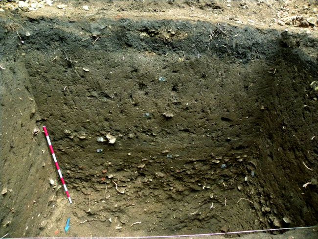
Figure 7. Prague New Town - ‘garden layer’, Opatovická Street no. 160 (photo by T. Cymbalak).
converted and used as gardens (often with added utility structures and buildings),
much to the annoyance of the town council.77
Large green spaces
Urban peripheries, especially in larger towns, were covered with vegetation, as
depicted on sixteenth-century views of, for example, Aachen, Duisburg and
Frankfurt am Main by Braun and Hogenberg.78 Cologne serves as a great example.
In the prospect view dated 1572, between the inner and the outer lines of fortifica-
tion, there are large, irregular, urban blocks marked with a regular pattern, which
represent green spaces (Figure 5a).79 Those areas were vineyards and gardens that,
according to the written records, existed in the outer part of the city from the
Middle Ages up to the nineteenth century. The first survey conducted in the seven-
teenth century registered that they covered about 30 per cent of the intramural
land.80 Their existence was an effect of Cologne’s specific urban development.
That post-roman city had been extended on a small scale several times until in
Untermann, ‘“Us hüser sol man nit gärten machen”’, 495.
77
78
See views on http://historic-cities.huji.ac.il/historic_cities.html, accessed 2 Mar. 2020.
79
W. Herborn, ‘Köln’, in W. Behringer and B. Roeck (eds.), Das Bild der Stadt in der Neuzeit 1400–1800
(Munich, 1999), 256–63.
80
W. Herborn and J. Koster, ‘“Vineae infra muros”: Zur Topographie und Größe stadtkölnischer
Weingärten’, in L. Clemens and B. Flug (eds.), Weinbau zwischen Maas und Rhein in der Antike und
im Mittelalter (Mainz, 1997), 421–79.
Downloaded from https://www.cambridge.org/core. IP address: 46.4.80.155, on 17 Jul 2021 at 10:14:20, subject to the Cambridge Core terms of
use, available at https://www.cambridge.org/core/terms. https://doi.org/10.1017/S0963926820000760You can also read