Enhancing Burkina Faso Regional Connectivity - World Bank 2019
←
→
Page content transcription
If your browser does not render page correctly, please read the page content below
Public Disclosure Authorized                                                     Public Disclosure Authorized   Public Disclosure Authorized   Public Disclosure Authorized

                                               Enhancing Burkina Faso Regional

               An Economic Corridor Approach
                                                                  Connectivity
                                                        2019
                                                        World Bank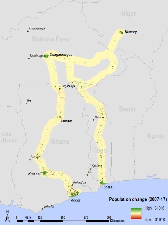
Acknowledgements

This report was prepared by Aiga Stokenberga (Transport Economist, IAFT4) and Mathilde Lebrand (Economist, INFCE)
under the leadership of Anca Cristina Dumitrescu (Lead Transport Specialist, IAFT4).

Assistance with road quality data assembly was provided by Eddy Bynens (Consultant). Lisa Warouw (Program Assistant,
IAFT4) and Desta Wolde Woldearegay (Program Assistant, IAFT2) provided coordination and logistical support.

External inputs and comments were provided by Ulrike Wood-Sichra, Senior Research Analyst at the International Food
Policy Research Institute (IFPRI), and by Melia Ungson, Swetha Ramaswamy, Katherine Quintero, and Grace Fenton of
Fraym.

The team would also like to express their gratitude to Megha Mukim (Sr. Urban Economist, SAFU1), Matias Herrera Dappe
(Sr. Economist, IAFT2), and Mustapha Benmaamar (Lead Transport Specialist, IAFT3) for their comments on the draft final
report, and to Soukeyna Kane (Country Director, AFCW3), Aurelio Menendez (Practice Manager, IAFT4), and Nicolas Peltier
(Practice Manager, IAFT3) for overall guidance.

On October 28, 2019, the study was presented to stakeholders from Burkina Faso, Togo, and Niger in an all-day workshop
held in the World Bank offices in Ouagadougou, Burkina Faso. This served the purpose of relaunching the Lomé-
Ouagadougou-Niamey regional project and resulted in rich discussions on project-level priorities as well as broader transport
and trade facilitation priorities in the three countries on the following sub-topics: road infrastructure investment needs;
logistics platforms (ports, border crossings, internal clearance terminals); transport sector reforms; and Customs reforms.
The team would like to thank Cheick Diallo (Sr. Transport Specialist, IAFT4), Monica Moldovan (Young Professional, IAFT3),
Olivier Hartmann (Sr. Private Sector Specialist, ETIRI), Jean Kanyamuhanda (Consultant, IAFT3), Lucien Barro (Consultant,
SAFU1), and Helene Karambiri (Program Assistant) for their contribution organizing the event, delivering the presentation
and guiding the discussions.

                                                                                                                                1
Abbreviations and Acronyms

ASYCUDA       UNCTAD Automated System for Customs Data
AU            African Union
CAGR          compound annual growth rate
CMC           Corridor Management Committee
ECOWAS        Economic Community of West African States
FAOSTAT       Food and Agriculture Organization Corporate Statistical Database
FCFA          Central African Franc
GDP           Gross Domestic Product
GIS           Geographic Information Systems
GoT           Government of Togo
GPS           Global Positioning System
ICD           inland container depot
IFPRI         International Food Policy Research Institute
ISRT          Inter-State Road Transit
ISTG          Inter-State Road Transit of Goods
JICA          Japan International Cooperation Agency
LPI           Logistics Performance Index
LTNDP         Long-Term National Development Plan (Ghana)
mt            Metric tons
NDPC          National Development Planning Commission (Ghana)
NEPAD         New Partnership for Africa's Development
NRTTFC        National Road Transport and Transit Facilitation Committee
NSDF          National Spatial Development Framework (Ghana)
OSBP          One-Stop Border Post
OTRAF         Burkina Faso Road Transporters Organization (Organisation des Transporteurs Routiers du Faso)
PAMOSET       Projet de Modernisation du Secteur des transports et facilitation du commerce sur le Corridor Abidjan-
              Ouagadougou
PDES          Social and Economic Development Plan (Niger)
PNDES         National Plan for Economic and Social Development (Burkina Faso)
PPP           public-private partnership
REC           Regional Economic Community
ReSAKSS       Regional Strategic Analysis and Knowledge Support System
RTFCC         Regional Trade Facilitation and Competitiveness Development Policy Credit
SCADD         Strategy for Accelerated Growth and Sustainable Development (Burkina Faso)
SCAPE         Strategy on Accelerated Growth and Employment Promotion (Togo)
SPAM          Spatial Production Allocation Model
TEU           twenty-foot equivalent unit
US$           United States Dollar
USAID         United States Agency for International Development
WAEMU         West African Economic and Monetary Union (Union Economique et Monétaire Ouest Africaine)
Contents

Executive summary........................................................................................................................................................................... 2
1. Context........................................................................................................................................................................................ 8
2. Objective and methodology ........................................................................................................................................................ 9
3. Regional and National Economic and Transport Policy Priorities .............................................................................................. 10
4. Transport and logistics characteristics of the corridors .............................................................................................................. 13
    4.1. The corridors and their role in trade .................................................................................................................................... 13
   4.2. Trade composition and partners ……………………………………………………………………. ………...……………………19

    4.3. Corridor infrastructure condition and soft gaps ................................................................................................................... 21
    4.4. Transport costs on the corridors ......................................................................................................................................... 26
5. The corridors’ socioeconomic characteristics and economic potential ...................................................................................... 29
    5.1. Characteristics and economic importance of the corridor immediate vicinity ...................................................................... 30
    5.2. Economic lagginess of sub-national regions in the study area ........................................................................................... 30
    5.3. Economic potential of sub-national regions in the study area ............................................................................................. 37
         5.3.1. Agglomeration potential and economic dynamism ...................................................................................................... 38
         5.3.2. Agricultural potential .................................................................................................................................................... 40
         5.3.3. Manufacturing potential ............................................................................................................................................... 43
         5.3.4. Summary………………………………………………………………………………………………………………………….44

6. Expected economic impacts of corridor investments and policies ............................................................................................. 45
    6.1. Regional-scale impacts: Insights from the application of a spatial general equilibrium model............................................ 47
    6.2. National and sub-regional impacts in Burkina Faso: Evidence from spatial accessibility analysis ..................................... 52
7. Policy implications and conclusions .…………………………………………………..………………………………………...……….56

References ………………………………………………………………………………………………………………………………..….. 59

ANNEX 1 The region's infrastructure condition ………………………………………………………………………………...………….61

ANNEX 2 Economic lagginess and potential of regions within the study area: detailed rankings ……………………...………….. 61

ANNEX 3 Ongoing and proposed investments and reform policies ……………………………………………….……………..……. 68

ANNEX 4 Background and assumptions for the spatial economic model and detailed results ……………………………...……… 69

ANNEX 5 Detailed results of the spatial accessibility analysis ………………………………………………………………...………...73

                                                                                                                                                                                                       1
Executive summary
Regional integration and international connectivity via economic corridors play an essential role in reducing the
isolation of West Africa’s landlocked countries such as Burkina Faso. Connectivity is key for poverty alleviation and
welfare in the more economically lagging regions and for unlocking the economic potential of agricultural areas and cities.
As suggested by their respective national development strategies, Burkina Faso as well as the three neighboring countries
considered in this study (Niger, Ghana, and Togo) all recognize the importance of transport corridor and rural infrastructure
investment in advancing development goals, economic transformation, and poverty reduction. The objective of this study is
to help define specific transport investment and complementary policy priorities.
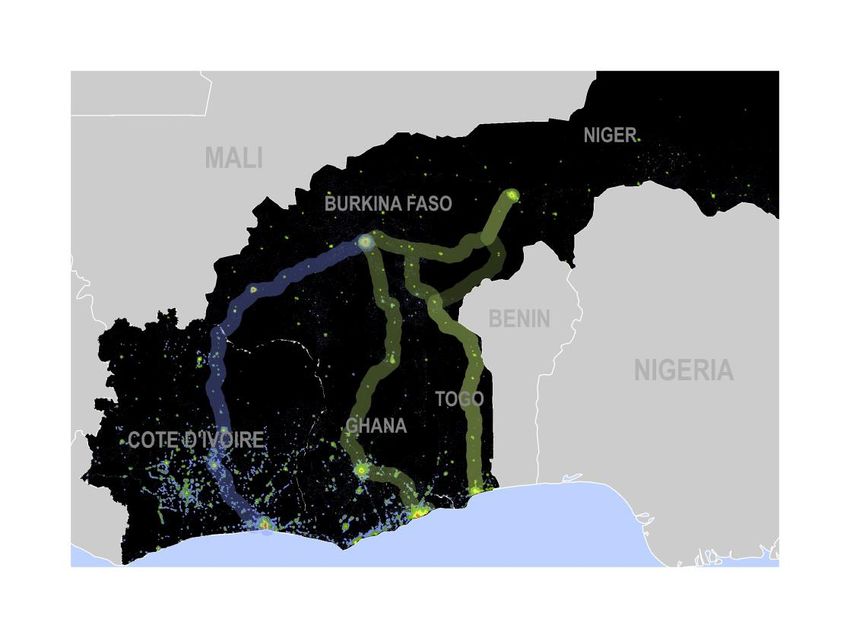
Burkina Faso’s main international corridors are the Ouagadougou-Lomé road corridor connecting it to Togo, the
Ouagadougou-Tema (Ghana) road corridor, and the Ouagadougou-Niamey (Niger) road corridor, as well as the
Ouagadougou-Abidjan (Cote d’Ivoire) road and rail corridors. In addition, the Niamey-Lomé (Niger-Togo) eastern road
corridor that also crosses Burkina Faso and uses the Burkina Faso-Togo border crossing at Ponio represents a potentially
important alternative corridor for landlocked Niger’s international trade.
Each of the corridors plays a unique role in regional integration, national trade, and sub-national rural and urban
development, by providing connectivity to consumption centers, economic production zones, and/or economically
lagging areas. The importance of a corridor at the regional versus national versus sub-national level informs the investment
and complementary policy interventions that should be prioritized to maximize the corridor’s overall impact. As summarized
in Table 1, nearly all the corridors in scope have regional importance, being included in the Economic Community of West
African States (ECOWAS) and West African Economic and Monetary Union (WAEMU) lists of priority corridors based on factors
such as their role in connecting the region’s capital cities, transit and trade volumes, and population catchment.
The national perspective suggests that the Ouagadougou-Lomé corridor is very important for Burkina Faso’s
imports, serving as the artery for about 40 percent of all cargo entering the country, while the Ouagadougou-Abidjan
road and rail corridors play an equally crucial role in allowing Burkina Faso’s exports to reach global markets. On
the other hand, Tema-Ouagadougou is of far greater importance for Ghana’s external and internal trade flows compared to
Burkina Faso, serving as the main axis connecting Ghana’s northern regions to the more prosperous southern production
areas and the port of Tema. In the case of Niger, the Niamey-Ouagadougou-Lomé corridor plays a significant role in the
country’s external trade, carrying 15-20 percent of Niger’s import transit, while the role of the Niamey-Lomé eastern corridor
through Burkina Faso is more aspirational, the route representing an alternative, albeit unutilized, trade artery for Niger.
Machine learning based analysis conducted for this study, which estimates the concentration of economic activity
in the corridors’ immediate vicinity, sheds additional insights on their national-level importance. The Ouagadougou-
Lomé 20-km buffer (radius) area represents a significant generator of economic activity for both Burkina Faso and Togo and
concentrates an important share of the two countries’ populations. Similarly, the extended Niamey-Ouagadougou-Lomé
corridor, linking Niger to Burkina Faso to the port of Lomé in Togo, is of major economic importance for Niger, despite the
short length of the corridor located in its territory. The 20-km buffer area of the corridor concentrates as much as 28 percent
of Niger’s Gross Domestic Product (GDP) and 7 percent of its population. For Burkina Faso, the respective figures are even
higher – 40 percent and 21 percent – while for Togo they reach 72 percent and 65 percent. In comparison, the Ouagadougou-
Tema corridor buffer area is of somewhat greater importance for Ghana, accounting for 39 percent of its population,
compared to 15 percent in the case of Burkina Faso. However, in terms of the concentration of economic activity (GDP), the
corridor’s buffer area is of comparable importance to both countries. Finally, the eastern route of the Niamey-Lomé corridor
in Burkina Faso’s territory remains sparsely traveled and populated, with little economic activity generated in its direct area
of influence. In contrast, the portion of the corridor located in Niger’s territory accounts for a major share of that country’s
GDP (28 percent) and population (7 percent).
Burkina Faso, similarly to its landlocked neighbor Niger, continues to rely on exports of a limited scope of (primarily)
unprocessed commodities and minerals. It runs a significant trade imbalance with not only the rest of the world but also
its neighbors. The trade imbalance vis-à-vis regional and global trading partners has direct implications for the landlocked
countries’ international transport and trade costs, given the need for transport prices on northbound (full) cargo flows to also
2
compensate for the southbound (mostly empty) flows. Identifying the economic potential that could be unlocked in each
country at the sub-national level, thus reducing the trade imbalance over time, provides yet another lens through which
corridor investment and complementary intervention priorities can be defined. Analysis conducted for this study using high-
resolution agricultural and other spatial data reveals that, significant untapped production potential exists in the entire study
area. The agricultural crop production potential is estimated at 12.84 million metric tons worth US$3.19 billion per year in
Burkina Faso alone, compared to 7.47 million mt (US$2.05 billion) currently utilized. Among Burkina Faso’ sub-national
regions crossed by the corridors in scope, current agricultural production and assessed potential production is highest in the
Center-East located on the Ouagadougou-Lomé route, where currently about 560,000 mt of agricultural crops worth US$157
million are produced annually, with the potential to reach 940,000 mt (US$237 million).1 The consideration of not only
agricultural production but also manufacturing and agglomeration dynamics at the sub-national level suggests greater overall
economic potential in Ghana (except its Northern region) and Togo, the western regions of Burkina Faso, and individual
regions in Niger that border Nigeria (see Figure 16). In Burkina Faso, Haut-Bassins on the route of the Ouagadougou-Abidjan
corridor emerges as the region with consistently high estimated economic potential, regardless of the dimension. The Central
region (home to Ouagadougou and the origin of the Ouagadougou-Lomé and Ouagadougou-Tema corridors) and Plateau-
Central (on the Ouagadougou-Niamey axis) also appear to present high potential along most indicators. Investments in
transport infrastructure in these regions would presumably have a higher economic return than in those where economic
potential is assessed to be low.

When considering the economic “lagginess” of the sub-national regions, as defined by high poverty rates and low
economic activity, the need for connective investment and complementary policy interventions appears to be
greatest in the predominantly low-density parts of the study area, such as Burkina Faso’s North region. However, it is
high also in the relatively densely populated regions of Niger that are close to the capital city and the Niamey-Lomé/Niamey-
Ouagadougou corridors – Tillaberi and Dosso – as well as in the Plateaux region in central Togo that is traversed by the
Ouagadougou-Lomé and the Niamey-Lomé corridors.

The region’s trunk road infrastructure is in fair-to-good condition on most sections, although large gaps remain on
corridors such as the eastern link between Lomé and Niamey. Several factors that add to cost of transport remain also
in terms of the “soft” aspects of transport and trade facilitation, including lingering freight sharing agreements that reduce the
competitiveness of transport service provision, little use of direct contracting of trucking services, low level of
professionalization of the overall trucking and logistics industry, and inefficiencies in border crossing and Customs processes
despite some recent investment in the physical border crossing facilities. Trucking costs absorb the largest share (>60
percent) of the total corridor transport costs for imports into Burkina Faso, while ports and border crossings/inland terminal
clearances represent another 20 percent and 15 percent, respectively. The Ouagainter internal clearance terminal in
Ouagadougou has seen impressive improvements in both cost and time in recent years; however, only slight improvements
on all corridors have been observed in the transport leg. In terms of the port leg, Lomé saw significant time and cost
reductions, in contrast to Tema or Abidjan.

The study develops several scenarios of corridor interventions that address the above inefficiencies to quantify the
expected impacts in terms of real income growth (via growth in trade) and domestic market accessibility. To do so,
it applies two complementary analytical tools, or “lenses”: a spatial general equilibrium model and a Geographic Information
System (GIS) based analysis.

             Regional and Sub-National Real Income Growth Impacts: Opportunities for better integration with foreign
             markets and subsequent economic gains are not even across sub-national regions within countries; they
             are driven by factors such as the potential to produce tradable goods (agricultural, manufacturing, etc.) and the
             region’s connectivity to the main transport corridors. Using a spatial general equilibrium model, we test six scenarios
             of corridor intervention “packages” to assess the expected impacts on real income growth at the District level in
             Burkina Faso and Niger, the study area’s two landlocked countries, using data on the District-level land area,
             number of employees, sectoral shares of employees, and transport costs. Four of the scenarios focus exclusively
             on corridor infrastructure improvement – (1) the Niamey-Lomé eastern corridor section in Burkina Faso, (2) the
             Niamey-Lomé/Niamey-Ouagadougou corridor section in Niger, (3) the Ouagadougou-Lomé/Niamey-Lomé corridor

1 Monetary   value of production calculated by IFPRI using past average international prices.

                                                                                                                                       3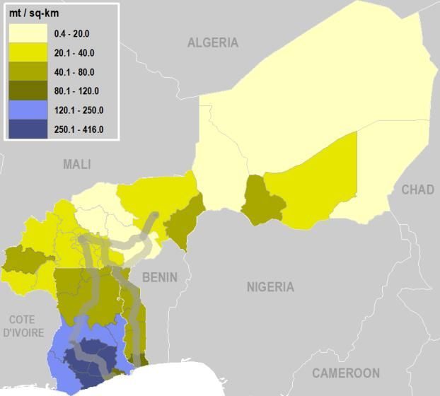
section in Togo, and (4) the three investments combined. The final two scenarios consider: (5) the combination of
all three corridor infrastructure improvements and the halving of the transport fixed costs, such as through improved
competition and transparency in the trucking services market and (6) the combination of all three corridor
infrastructure improvements and the halving of international border and port costs, such as through improved port
efficiency that reduces the truck turnaround times when picking up cargo.

The model results suggest that Niger in particular can be expected to benefit from infrastructure
investment on the transport corridors that link it to Burkina Faso and further to the port of Lomé, with real
incomes to increase by between 0.17 percent (assuming the improvement of the corridor section in Togo) and 0.52
percent (assuming the improvement of the corridor section in eastern Burkina Faso). In the case of Burkina Faso,
the expected real income growth is much more modest, except in the case of the improvement of the
Ouagadougou-Lomé/Niamey-Lomé corridor section in Togo which would increase Burkina Faso’s real income by
about 0.12 percent. This latter result is intuitive given the superior importance of the Ouagadougou-Lomé corridor
in Burking Faso’s external trade flows and the high economic potential of the areas the corridor crosses (e.g. the
Center-East region).

However, the most important observation from this analysis is that complementary interventions that make
the transport sector more efficient and reduce border and port costs would substantially amplify the
income gains from corridor infrastructure improvements for both Niger and Burkina Faso. The gains would
be particularly high for Burkina Faso with the complementary reductions in the fixed costs of the transport leg,
increasing real incomes by 1.39 percent, compared to 1.32 percent in the case of complementary reductions in the
fixed border and port costs. For Niger, the result is inverse: halving of the border and port costs (in addition to the
infrastructure improvements) would increase real incomes by 2.57 percent, compared to 2.32 percent if assuming
the complementary reductions in the fixed costs of the transport leg. Under all scenarios, Niger, on average, is
expected to benefit more than Burkina Faso, the difference in income gains being the smallest in the case of the
Ouagadougou-Lomé/Niamey-Lomé corridor improvement in Togo.

The real income gains will be unevenly distributed also at the sub-national level: in each of the two
countries, real income growth would be five to six times higher in the District that will gain the most
compared to the District that will gain the least. Only the Districts with high potential to produce tradable goods
and those that are well-connected will get the most out of corridor investments: for example, in the absence of good
quality roads between the locations of export production, especially agriculture, and the main corridors, the impacts
of corridor infrastructure investment on exports will remain limited. A more comprehensive, integrated policy
approaches will more effectively support local value creation and development of areas along the corridors,
preventing the wider economic benefits from being spatially concentrated only in the main corridor nodes.

Domestic Market Access Impacts: Corridor and adjacent road improvement will also have more localized
economic impacts, through improved access to domestic markets for consumers and producers. To
quantify these impacts for Burkina Faso specifically, we test four scenarios through the application of GIS-based
accessibility analysis. The first three scenarios build upon each other, considering (1) the improvement of the
Niamey-Lomé eastern corridor section in Burkina Faso, (2) in addition to the improvement of a portion of the
Niamey-Ouagadougou axis in Burkina Faso, (3) in addition to the improvement of the secondary and tertiary roads
connecting these two corridor sections. The final scenario considers the improvement of road sections in southern
Burkina Faso that provide a connection between the Ouagadougou-Tema and the Ouagadougou-Lomé corridors.

At present, 54 percent of the country’s population is estimated to live within 2 hours of motorized travel to
the nearest major city (market), while 5 percent live 5 or more hours away – the country’s North and East
region, the latter crossed by the Niamey-Lomé eastern corridor, are characterized by particularly low accessibility.
The analysis finds that the improvement of the Niamey-Lomé eastern corridor section in Burkina Faso would result
in a significant reduction in travel time to the nearest major local market for about 19,000 people; the added
rehabilitation of the eastern half of the Niamey-Ouagadougou axis would increase the number of beneficiaries to
nearly 64,000, while the added improvement of the more minor roads connecting these two corridors would make
the biggest difference, nearly doubling the figure to 119,000. Finally, the improvement of the road connecting the

                                                                                                                          4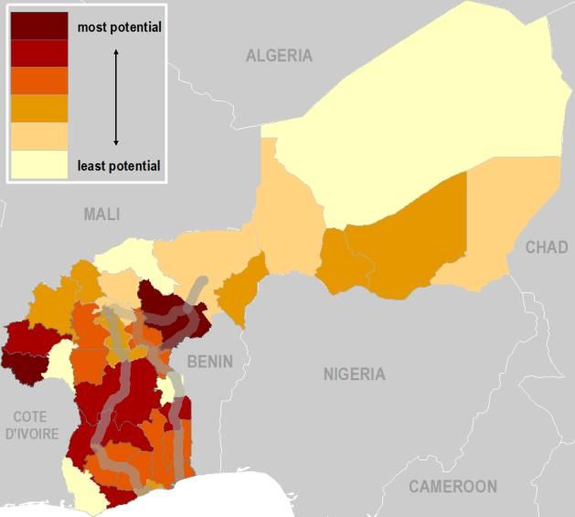
Ouagadougou-Tema and the Ouagadougou-Lomé corridors in southern Burkina Faso would significantly reduce
         travel time to a major city for about 34,000 people, hence, double the number of beneficiaries as expected from
         the improvement of the Niamey-Lomé eastern corridor.

         In addition to the market accessibility benefits for the local consumers, the improvement of the Niamey-
         Lomé eastern route in Burkina Faso would result in a significant reduction in travel time to market for an
         annual volume of about 5,200 mt of staple crops – rice, maize, millet, and sorghum (12,000 mt if assuming
         full utilization of production potential), with an annual market value of US$650,000 (US$2 million). The added
         improvement of the Niamey-Ouagadougou corridor would increase this figure to 30,000 mt (69,300 mt), worth
         US$3.7 million (US$11.2 million), while the addition of improvements of the roads connecting the two corridors
         would raise it to 47,000 mt (>100,000 mt), worth US$5.7 million (US$16.2 million). Good accessibility to local
         markets is yet more important for the incomes of the agricultural producers growing perishable agricultural produce
         such as fruits and vegetables, given that it can rapidly lose value in the absence of a well-integrated cold chain and
         risks to be damaged if transported for long hours. The improvement of the Niamey-Lomé eastern route would
         significantly reduce travel time to market for 475 mt of perishable produce annually, worth about US$136,000 (or
         640 mt worth US$187,000 if assuming the utilization of the full production potential). The added improvement of
         the Niamey-Ouagadougou route would increase those figures more than five-fold, to over 2,500 mt worth
         US$770,000 (or 4,000 mt worth US$1.2 million). Finally, the added improvement of the connecting roads would
         bring nearly double the volume and value of produce closer to market compared to the scenario in which only the
         main corridor sections in eastern Burkina Faso are rehabilitated. In contrast to the market accessibility benefits for
         consumers, the improvement of the roads connecting the Ouagadougou-Tema and Ouagadougou-Lomé corridors
         in southern Burkina Faso would have less of an impact on market accessibility for agricultural produce – either
         staple crops or perishable goods – compared to the improvement of the Niamey-Lomé eastern corridor.

To conclude, depending on the perspective applied, the investment and policy priorities that emerge differ to some
extent. Analysis of the national-scale relevance of each of the corridors highlights the particularly high economic importance
of the Ouagadougou-Lomé and the extended Niamey-Ouagadougou-Lomé corridors for three of the region’s economies
(Niger, Burkina Faso, and Togo), in contrast to the Niamey-Lomé eastern corridor which does not move significant trade
volumes nor generates much economic activity in its direct vicinity in Burkina Faso; it therefore does not appear to be a
priority corridor for improvement from Burkina Faso’s national perspective. The Ouagadougou-Tema corridor is a major trade
artery for Ghana and a concentrator of economic activity in both Ghana and Burkina Faso; therefore, its future improvement
would directly benefit local production in both countries. Further, the sub-national perspective suggests that investment in
the Ouagadougou-Tema or the Ouagadougou-Lomé corridors in particular would allow developing the high production
potential of several sub-national regions of Ghana, Togo, and Burkina Faso. Improvement of the Ouagadougou-Lomé
corridor would be especially important for unlocking the high agricultural potential of Burkina Faso’s Center-East region and
of the southern- and northern-most regions of Togo. Finally, investment in the Niamey-Lomé eastern corridor and the
Niamey-Ouagadougou route may be prioritized more if applying the economic lagginess metric and the need to “link in”
economically fragile areas.

To realize either the trade or the domestic market access benefits of corridor improvements, complementary
interventions will be essential to maximize the value of the corridor infrastructure investments. Complementary
border crossing and port efficiency improvements as well as reductions in the fixed costs of transport will significantly
enhance the real income gains that can be expected from corridor infrastructure improvement. Local production capacity of
tradable goods must be strengthened through providing last-mile links to sub-national regions with high production potential,
and the trunk corridor infrastructure investment accompanied by investment in rural access and ancillary facilities like
agricultural consolidation and processing centers, to allow agricultural value chains and higher value-added agricultural
sectors to prosper. In other words, a key challenge for Burkina Faso and its neighbors is to transform the transport corridors
into fully integrated economic corridors, complementing high-quality trunk corridor infrastructure and functioning border
crossings with well-developed production and logistics chains that allow tapping the full agricultural and manufacturing
potential and promote trade with global and sub-regional markets.

                                                                                                                                  5
Table 1: Summary of regional, national, and sub-national relevance of the corridors

                                                                                       Corridor role in connecting high-potential or
 Corridor         Regional importance            National importance                                                                         Impacts of scenario interventions
                                                                                       lagging sub-national regions

                                                 ~30-35% of imports enter BFA
                                                 through this corridor; over 55% of
                                                                                       BFA:
                                                 BFA exports travel on this corridor
                                                                                       Ag. potential: Haut-Bassins, Centre-Ouest, and
 Ouagadougou-     ECOWAS and WAEMU               (cotton)                                                                                    Not assessed (corridor has been studied in detail
                                                                                       Cascades; Agglomer. potential: Haut-Bassins,
 Abidjan          priority corridor                                                                                                          as part of previous World Bank operations)
                                                                                       Centre-Ouest, and Cascades; Manuf. potential:
                                                 Serves CVI’s internal trade
                                                                                       Centre
                                                 (domestic traffic ~90% of Port of
                                                 Abidjan traffic)

                                                 ~25% of imports enter BFA
                                                                                       BFA:
                                                 through this corridor                                                                       Domestic market accessibility impacts:
                                                                                       Agglomer. potential: Centre-Sud (rapid increase in
                  ECOWAS corridor
                                                                                       the share of urbanized land); Manuf. potential:
                                                 A gateway corridor for GHA (80-                                                             Rehabilitation of N20 and N25 in southern BFA
                                                                                       Centre
                  Corridor 20-km buffer          90% of cargo on the corridor has a                                                          (connecting the corridor to nearby regions): BFA:
 Ouagadougou-
                  zone:                          GHA origin and destination)                                                                 Significant reduction in travel time for 34,000
 Tema                                                                                  GHA:
                  29% of BFA/GHA                                                                                                             people; 4,600 mt of staple crops (7,900 mt if
                                                                                       Ag. potential: Greater Accra, Upper East, Eastern;
                  combined population and        Corridor 20-km buffer zone:                                                                 assuming full utilization of ag. potential) with an
                                                                                       Agglomer. potential: Brong Ahafo, Northern, and
                  41% of their GDP               GHA: 39% of pop., 42% of GDP,                                                               annual market value of US$460,000 (US$1.2
                                                                                       Ashanti; Manuf. potential: Greater Accra, Upper
                                                 26% of the poor; BFA: 15% of                                                                million)
                                                                                       East, Eastern
                                                 pop., 36% of GDP, 2% of the poor

                  ECOWAS and WAEMU                                                     BFA:
                                                 Primary gateway corridor for BFA:
                  priority corridor                                                    Ag. potential: Centre-Est (high staple crop
                                                 ~40% of imports enter BFA
                                                                                       production potential and high density of livestock
                                                 through this corridor
                  Serves significant bilateral                                         production; Agglomer. potential: Centre-Est (rapid
                  trade between TOG and                                                increase in urbanized land); Manuf. potential:
                                                 Corridor has high importance for                                                            Real income growth impacts:
                  BFA (clinker)                                                        Centre
 Ouagadougou-                                    TOG’s industrial development
 Lomé                                                                                                                                        Rehabilitation of RN1 in TOG: BFA: 0.12%; NER:
                  Lomé-Ouagadougou-                                                    TOG:
                                                 Lomé-Ouagadougou-Niamey                                                                     0.17%
                  Niamey extended corridor                                             Ag. potential: Maritime (both staple and cash
                                                 extended corridor 20-km buffer:
                  20-km buffer:                                                        crops), Savanes (staple crops), Plateaux (staple
                                                 BFA: 21% of pop., 40% of GDP,
                  42% of BFA/TOG/NER                                                   crops); Agglomer. potential: Centre, Savanes (rapid
                                                 8% of the poor; TOG: 65% of pop.,
                  combined GDP and 23%                                                 pop. growth); Manuf. potential: Maritime, Kara;
                                                 72% of GDP, 37% of the poor
                  of their pop.                                                        Lagging: Plateaux

                                                                                                                                                                                                   6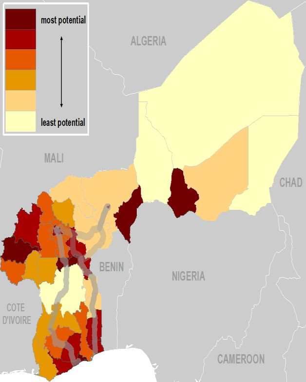
Real income growth impacts:
                                               The most commonly used
                                                                                                                                           Rehabilitation of NR6 in NER: BFA: none; NER:
                                               connection for NER’s trade via the
              ECOWAS and WAEMU                                                                                                             0.25%
                                               Port of Lomé; Lomé-                   BFA:
              priority corridor; part of the
                                               Ouagadougou-Niamey carries 15-        Agglomer. potential: Est (rapid increase in
              Trans-Sahelian Highway                                                                                                       Domestic market accessibility impacts:
                                               20% of NER’s import transit           urbanized land)
Niamey-
Ouagadougou   Connects the capital cities                                                                                                  Rehabilitation of N4 in BFA (assuming that NR19
                                               Lomé-Ouagadougou-Niamey               NER:
              of BFA and NER, serving                                                                                                      is also rehabilitated): BFA: Significant reduction in
                                               extended corridor 20-km buffer:       Ag. potential: Niamey (staple crops); Manuf.
              the countries’ bilateral                                                                                                     travel time for 64,000 people; 30,000 mt of staple
                                               BFA: 21% of pop., 40% of GDP,         potential: Niamey; Lagginess: Tillaberi
              trade                                                                                                                        crops (69,300 mt if assuming full utilization of ag.
                                               8% of the poor; NER: 7% of pop.,
                                                                                                                                           potential) worth US$3.7 million (US$11 million);
                                               28% of GDP, 1% of the poor
                                                                                                                                           and 2,500 mt of perishable produce worth
                                                                                                                                           US$770,000 (4,000 mt, US$1.2 million)

                                                                                                                                           Real income growth impacts:

                                                                                                                                           Rehabilitation of NR19 (BFA), NR6 (NER), and
                                                                                                                                           RN1 (TOG): BFA: 0.13%; NER: 0.95%
                                                                                     BFA:
                                               The corridor represents an
                                                                                     Agglomer. potential: Est (rapid increase in           Rehabilitation of NR19 (BFA), NR6 (NER), and
                                               alternative route for NER to access
                                                                                     urbanized land)                                       RN1 (TOG) + halving of fixed transport costs:
                                               the Port of Lomé (150 km shorter
                                                                                                                                           BFA: 1.39%; NER: 2.32%
                                               than Niamey-Ouagadougou-Lomé)
                                                                                     NER:
              Corridor 20-km buffer:
                                                                                     Ag. potential: Niamey (staple crops); Manuf.          Rehabilitation of NR19 (BFA), NR6 (NER), and
              15% of the combined              Corridor 20-km buffer area:
Niamey-Lomé                                                                          potential: Niamey; Lagging: Tillaberi                 RN1 (TOG) + halving of border and port costs:
              BFA/TOG/NER population           TOG: 65% of pop., 71% of GDP,
(eastern)                                                                                                                                  BFA: 1.32%; NER: 2.57%
              and 23% of their combined        52% of the poor; NER: 7% of pop.,
                                                                                     TOG:
              GDP                              28% of GDP, 1% of the poor; BFA:
                                                                                     Ag. potential: Maritime (both staple and cash         Domestic market accessibility impacts:
                                               2% of pop., 1% of GDP, 3% of the
                                                                                     crops), Savanes (staple crops), Plateaux (staple
                                               poor; poverty rate inside the 20-km
                                                                                     crops); Agglomer. potential: Centre, Savanes (rapid   Rehabilitation of NR19 in BFA: BFA: Significant
                                               buffer is higher than outside (68%
                                                                                     pop. growth); Manuf. potential: Maritime, Kara;       reduction in travel time for 19,000 people; 5,200
                                               vs. 52%)
                                                                                     Lagging: Plateaux                                     mt of staple crops (12,000 mt if assuming full
                                                                                                                                           utilization of ag. potential) with annual market
                                                                                                                                           value of US$650,000 (US$2 million); and 475 mt
                                                                                                                                           of perishable produce worth US$136,000 (640 mt,
                                                                                                                                           US$187,000)

                                                                                                                                                                                                   7
1. Context
Transport corridors connect ports, and thus international trade flows, to surrounding hinterlands, sometimes across borders.
However, they also hold the potential to promote integration within or between countries and regions, and to support linkages
between industries, firms, and people. The economic corridor approach looks at regional transport routes not only as a
means of transporting goods and services or as a gateway for landlocked countries but also as a tool for stimulating social
and economic development in the surrounding areas. Economic corridors accomplish this by creating ancillary facilities in
conjunction with core transport infrastructure. In doing so, they help develop rural and border areas, create employment and
increase household earnings. Literature on the topic distinguishes between several stages of corridor transformation: (1)
physical development (upgrading infrastructure, revamping transport links), (2) logistics development (facilitating storage,
warehousing, trucking, insurance and freight management), and (3) economic and social development (investments in areas
such as agroindustry, manufacturing, special economic zones along the corridor). Developing economic corridors also
depends on the regulatory structure which impacts growth of economic activity, availability of other necessary infrastructure
such as electricity and water, and incentives for production and trade (see, e.g., USAID, 2017).
In a landlocked country such as Burkina Faso, regional integration and international connectivity via economic and logistics
corridors play an essential role in reducing isolation vis-à-vis the outside world. Connectivity is key for poverty alleviation and
welfare in the more economically lagging regions, and for unlocking the economic potential of agricultural areas and urban
centers. For its international transport, Burkina Faso has a choice between several transit ports, enabling it to take advantage
of competition between various access corridors. International road transport flows (imports and exports) follow three main
international transit corridors to and from Ouagadougou, Burkina Faso’s capital and largest city: Ouagadougou-Lomé (950
km);2 Ouagadougou-Tema (1,040 km), and Ouagadougou-Abidjan3 (1,100 km); as well as the Trans-African/Sahelian West
African Economic and Monetary Union (WAEMU) corridor linking Ouagadougou to Niamey in Niger (~500 km)4 and to
Bamako in Mali (970 km).
Except for rail traffic between Ouagadougou and Abidjan, the rest of Burkina Faso’s traffic moves along corridors by road.
Burkina Faso is the most important user of the port of Tema besides Ghana itself: its transit traffic represents 70 percent of
total Tema international transit traffic (2012). However, about 70 percent of Burkinabè import comes through the ports of
Lomé and Abidjan – 40 percent and approximately 30 percent, respectively (Saana Consulting, 2015a). Ghana and Cote
d’Ivoire also represent a large share of Burkina Faso’s overall imports by value – about 16 percent and 11 percent,
respectively – while Niger and Togo each represent about 4 percent (Harvard University, 2016). Niger’s international trade
relies mainly on the Cotonou-Niamey axis, but Niamey-Ouagadougou-Lomé is the next most important international transit
corridor. Togo is more dependent on regional trade than other coastal countries such as Ghana or Cote d’Ivoire, due to the
limited size of its domestic market: Togo’s domestic traffic represents only 26 percent of the activity at Lomé port, transit
represents 18 percent, and the balance is transshipment.
Rail transport in West Africa is limited and links only two capital cities with ports for the movement of freight; Abidjan (Côte
d'Ivoire) to Ouagadougou (Burkina Faso) and Dakar (Senegal) to Bamako (Mali).5 The only other rail link in West Africa can
only be used in combination with road for the movement of goods from a seaport to a commercial capital in the hinterland
(Cotonou–Niamey rail-and road corridor). Rail plays an important role on the Ouagadougou-Abidjan corridor.
Available research shows that transport costs in West Africa are reasonably low, due to the low labor cost, use of old trucks,
etc.; in contrast, the transport prices paid by shippers are relatively high, as a result of a combination of several market
distortions and poor transport sector governance, among other factors (Bove et al., 2018, provide a full account of the political
economy issues in West and Central Africa’s trucking sector).
2 While the road corridor from Lomé to Niamey transits Burkina Faso, it does not need to go through Ouagadougou. The existing corridor goes
through Fada N’Gourma; however, the distance between Lomé and Niamey can be reduced by about 150 km by using the currently unutilized
route crossing eastern Burkina Faso and the Togo-Burkina border at Ponio.
3 This corridor is not analyzed in detail in the current study because it was/is already extensively covered by a regional budget support
operation on trade facilitation and logistics reforms financed by the World Bank and subsequent ongoing technical assistance projects in both
countries. The results of the first operation in the series are summarized in Annex 2. A brief description of the corridor is provided in Section 4.
4 Ouagadougou-Dori-Tera-Farie-Namaro-Niamey, according to UEMOA list of Community Roads
5 Although Dakar-Bamako railway corridor has not been operational since 2018
8Road infrastructure on the main corridors has benefited from the support of the donor community, and notable improvements
have been achieved. Similarly, policy reforms to correct the market distortions and increase the value of such investments
in infrastructure have started to follow.6 USAID (2017) assessed the road connectivity among Burkina Faso, Ghana, Togo,
and Niger to be good to fair, as all capital cities and main population centers are linked with paved roads. Nevertheless, the
current level of the road condition is variable, as later sections of this study will explain in more detail.
The transport sector is still dominated by a large majority of small, informal, and inefficient transporters who rely on
intermediaries and market organizers to find freight. While this opaque allocation creates sizeable rents, truckers only obtain
break-even rates. Low profitability creates strong incentives for small truckers to resort to short-term survivalist behaviors,
including through overloading of trucks beyond the legal axle load limit. Overloading adversely affects the durability and
safety of operations, damages the road network, and discourages containerization. In addition, and specific to a landlocked
country like Burkina Faso, due to the high imbalance between import and export volumes, most of the trucks return to the
ports empty (Bove et al. 2018), pushing up the transport prices for inland-bound cargo. While reforms in the transport sector
services are ongoing in Burkina Faso and Togo, the situation is dire in Niger, which has only sporadically benefitted from
support in these areas.
Another major problem affecting the profitability of the trucking industry and increasing trade costs is the slow rotation time
on corridors, that is, the small number of roundtrips from Ouagadougou to any of the ports and/or international destination
by the average truck. This is the result of a combination of several factors, including delays at the port, difficulty to find
backhaul cargo, and cumbersome border and transit procedures in both coastal and hinterland countries. Long delays at the
border and multiple customs and police controls, Customs escorts (in Burkina Faso), lack of harmonized transit procedures
and Customs interconnection are among the issues affecting the region. Joint border posts have just started to be
operational; however, improved efficiency and reduced time passed by trucks at the border have not yet been achieved.
2. Objective and methodology
Based on the critical importance of transport links for the economy, the Government of Burkina Faso has placed importance
on supporting transport and logistics related activities in its long-term development strategy. The Government’s objective is
to establish well-functioning links to the neighboring countries, via putting in place appropriate infrastructure and reliable and
less costly transport services. In parallel with the function that transport infrastructure and policy interventions can play in
expanding the country’s international trade and unlocking the productive potential of certain regions, however, their
prioritization can also be viewed through the lens of poverty alleviation, accessibility to local markets, and linking-in of
economically lagging, isolated areas. Due to the scarcity of resources, it is important that Burkina Faso takes well-informed
decisions on which infrastructure investments and policies can amplify the net benefits, viewed through either of the lenses.
Moreover, the transport infrastructure and trade facilitation measures implemented in Burkina Faso may have effects well
beyond its borders, possibly generating sizable economic benefits for some regions in its neighboring countries while
reducing the competitiveness of others.
The objective of this study is to help prioritize transport infrastructure investments and related policy interventions in Burkina
Faso and its neighboring countries. Specifically, it aims to inform regional transport operations involving Burkina Faso, such
as the World Bank-financed Lomé-Ouagadougou-Niamey Regional Corridors Project, currently under preparation. It
complements the knowledge generated through the ongoing PAMOSET project financed by the World Bank (focused on
logistics and trucking industry reforms) and expands on the recent West and Central Africa Trucking Competitiveness Study
(Bove et al., 2018).
After reviewing the regional and national economic and transport policy priorities, the remainder of the study includes:
6Recent projects supporting transport policy reforms are: Abidjan-Ouagadougou DPO series (closed 2017); and the ongoing PAMOSET, a
Technical Assistance project financed by the World Bank to help implement reforms focused on the trucking industry, including related to
overloading, professionalization, and fleet renewal.
9(i) An analysis of the economic costs of inefficiencies of the transport/logistics systems on the Ouagadougou-Lomé,
Ouagadougou-Tema, Niamey-Ouagadougou-Lomé, and Niamey-Lomé-(via the Ponio border crossing in Togo and
eastern Burkina Faso) road corridors, through a comprehensive characterization of the transport infrastructure and
“soft” bottlenecks that increase transport and trade costs on these trade routes;
(ii) Characterization of the economic characteristics of the areas the corridors connect:
• The economic importance of the immediate (20-km radius) “buffer” zones of each of the corridors in scope;
• The economic potential and the economic “lagginess” of the sub-national regions of the four countries; and
(iii) An estimate of the economic impacts – both local and regional – of alternative road improvements and trade
facilitation measures on the selected corridors by applying two complementary analytical approaches – a spatial
general equilibrium model and GIS-based local accessibility analysis.
3. Regional and National Economic and Transport Policy Priorities
Over the past two decades, African Union (AU) programs such as NEPAD and the programs developed by the Regional
Economic Communities (RECs) have all increasingly placed priority on enhancing interconnectivity and facilitating trade by
focusing on transport corridors as microcosms of integration and spatial development (Nathan Associates, 2013). The vision
of the Economic Community of West African States (ECOWAS), of which Burkina Faso, Togo, Niger, and Ghana are member
states, is a single market with free movement of persons, near seamless movement of goods and cross-border business
stimulating intra-regional trade, increased value-added production and regional integration. The primary structure for
achieving this vision is the Corridor – a highway, railway, or intermodal system that connects multiple states and offers
efficient, cost-effective transport and logistics services for travel, trade and other types of business (USAID, 2017).
BURKINA FASO
A long-term vision study on “Burkina 2025”, completed at the end of 2005, proposes an accelerated growth model focused
on growth poles, niche production, and pro-poor growth. The sectors prioritized for development include agriculture, mining,
crafts, culture and tourism related industries, and small and medium enterprises. A key strategic orientation of the vision is
the promotion of economic integration and foreign trade, including the opportunities they offer for domestic production. The
vision also prioritizes the development of infrastructure and transport and logistics services to support agro-pastoral
businesses, create jobs, and reduce poverty. The subsequent Strategy for Accelerated Growth and Sustainable
Development (SCADD 2011-2015) highlights the necessity to correct weaknesses of the economy, vulnerability to external
shocks, and low agricultural productivity, in addition to high production cost and raising poverty levels. It considers “Burkina
2025” and adopts a poverty reduction approach focused on developing local productive capacities (JICA, 2018b).
The National Plan for Economic and Social Development (PNDES 2016-2020) aims at structurally transforming the
Burkinabe economy, through developing a productive agro-forestry-pastoral sector, a competitive industrial and artisanal
sector, high value-added services industries, and high quality infrastructure that fosters the structural transformation of the
economy.7 Among others, the expected impacts of PNDES is a decrease in the incidence of poverty to less than 35 percent.
The Ministry of Infrastructure formulated a Strategy Paper for the Burkina Faso Transport Sector for 2011-2025, and currently
two key projects are under implementation: modernization of truck fleet registration and truck fleet renewal (JICA, 2018b).
TOGO
7 Plan National de Développement Economique et Social (PNDES) 2016-2020, pp. 42-43.
10The Strategy on Accelerated Growth and Employment Promotion (SCAPE 2013-2017) offers a development framework for
Togo for the medium term. Its five strategic areas include the development of high growth potential sectors; strengthening
economic infrastructure; development of human capital, social protection and employment; strengthening governance; and
promoting participatory, balanced and sustainable development. Agricultural sectors, trade, services, mining, manufacturing
and tourism are considered as the main generators of strong and sustainable growth. In an important aspect of the SCAPE
related to the infrastructure sector, the Government of Togo (GoT) places emphasis on utilizing the advantages of having a
deep-water seaport to develop a North-South logistics corridor for development and trade. The North-South corridor is also
envisioned to play a key role in bridging the wealth gaps among the sub-regions it crosses (JICA, 2018b). As part of the
implementation of the North-South Development Corridor, the GoT intends to rely on public-private partnership (PPP)
mechanisms for financing major infrastructure projects.
The more recent National Development Plan for 2018-2022 (République Togolaise, 2018) identifies the main priorities that
Togo must address to achieve a structural transformation of the economy: e.g., development of a logistics and transport
chain around the Port of Lomé by integrating it into a renovated transport network; development of value chains in the agro-
sylvo-pastoral sector through the establishment of “agro-poles” combining several activities (food crops, aquaculture,
processing and research); creation of integrated industrial parks for export-oriented and labor-intensive industries (e.g.
textiles); and the development of the phosphate processing sector and the strengthening of the limestone processing sector.
In 2015, Togo’s National Transportation Policy for 2014-2030 was formulated based on SCAPE. The Policy emphasizes the
importance of the improvement and maintenance of the National Road No.1 between Lomé and Cinkassé as a national
North-South corridor. At the same time, the need to rehabilitate East-West connecting roads and access bridges to
neighboring countries is stressed in order to improve access to major agricultural production areas (JICA, 2018b).
GHANA
Ghana’s most recent Coordinated Programme of Economic and Social Development Policies, 2014-2020, outlines two main
priorities: good governance and the promotion of light manufacturing that builds upon Ghana’s existing natural resource
endowments, such as agro-industry and wood processing. In the recent Government of Ghana policies, a key challenge
identified is the need to form more economically and spatially integrated sub-regional economic relationships between Ghana
and its neighbors, whereby Ghana could attract foreign and domestic investment in the development of productive sectors
targeting sub-regional markets, as well as overseas markets.
The National Spatial Development Framework (NSDF) is a 20-year strategy for spatial development at the national level.
Concentrated development is recommended as an overall policy in the NSDF. This policy will be implemented through
strategies such as promoting urban settlements along major transport corridors and maintaining and improving the efficiency
of the main expressway network. The preparation of the 40-year Long-Term National Development Plan (LTNDP) was
launched in 2015 by the National Development Planning Commission (NDPC). The NDPC has also prepared a National
Infrastructure Plan (2018-2047).
The NSDF 2015-2035 proposes the development of several transport links, including a national and international expressway
system (e.g. Accra-Kumasi and Kumasi-Paga expressways); new and improved trunk roads (e.g. around Lake Volta); a
national and international railway network; and an agricultural growth corridor (e.g. a trunk road from Accra to Bolgatanga)
(JICA, 2018b). In February 2017, the Ministry of Railways Development was established for ensuring the rapid development
of the railway network, partly due to the needs of the mining industry, and has identified several railway lines as their priority
projects, including the Accra-Kumasi Line (300 km) and Kumasi-Paga (Central Spine) Rail (595 km) (JICA, 2018b).
NIGER
Acceleration of economic growth by investing in rural infrastructure is highlighted as a focus area in Niger’s Social and
Economic Development Plan (PDES 2017–2021). The National Strategy of Transport of Niger (2016-2025), covering road,
rail, and inland water transport, aims, among others, to optimize the development and management of the transport
infrastructure to support the country’s socio-economic development and to facilitate transport and transit through major
corridors through the development of road and rail infrastructure, as well as by improving the supply chain and simplifying
11You can also read