ENMAP - THE GERMAN HYPERSPECTRAL MISSION
←
→
Page content transcription
If your browser does not render page correctly, please read the page content below

EnMAP – The German Hyperspectral
               Mission
Sabine Chabrillat1, Karl Segl1, Saskia Foerster1, Luis Guanter2,1,
  Sebastian Fischer2, Godela Rossner2, Michael Bock2, Anke
                   Schickling2, Tobias Storch3
              and further EnMAP Team members
        1Helmholtz Center Potsdam German Research Center for Geosciences (GFZ)
                           2Universitat Politècnica de València
                 3Space Administration, German Aerospace Center (DLR)
            4Earth Observation Center (EOC), German Aerospace Center (DLR)
Imaging Spectroscopy & Science Quantitative mapping for a wide range of research fields Great potential for new (and unexpected!) applications

EnMAP satellite program
Environmental Mapping and Analysis Program (DLR/GFZ)
Study environmental changes, investigate ecosystem responses to human activities,
and monitor the management of natural resources
Operational mission with scientific focus
Provide high-quality calibrated
hyperspectral data
Measurements of key biophysical and
geochemical parameters
German project, core funding from BMWi
Currently in phase D
5-year operational phase
Open data policy for scientific users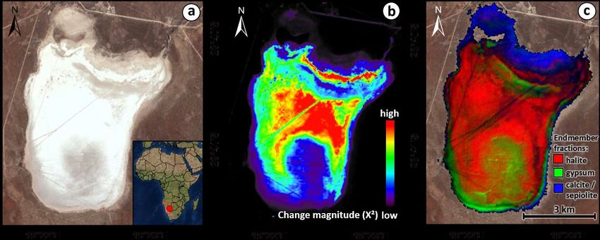
EnMAP mission and sensor parameters

                                                                Guanter et al.,
                                                                Rem. Sens., 2015

                            1000 km per Orbit

                                                5000 km a Day
Space segment
Two spectrometers (VNIR and SWIR) with common optics (telescope and double slit
system). Curved prisms to minimize smile and keystone
Onboard calibration through sun diffuser as well as calibration spheres for linearity
Telescope
VNIR
channel
SWIR
channel
-   Status: Successful integration of SWIR cameras and
    characterization of the instrument optical unit
- To do: Finalization and testing of the platform
- Launch 1st half 2021
Ground segment Development of the EnMAP processor: processing chain for systematic und radiometric correction (Level 1B) orthorectification (Level 1C) atmospheric correction (Level 2A) Instrument Cal & QC system Long-term-archiving of products Provision of a web-interface for the user for Ordering of products and acquisitions Delivery of products Mission operations Data reception In its technical verification phase

EnMAP users

                                       register
                                                  access
  Internal User
    • Mission
    • Charter
                                       proposal
  Category I
    • Based on
       science AO
    • With proposal
  Category II            acquisition                       free and open
    • Based on
       Space
       Administration
    • Without proposal
  Background Mission
EnMAP scientific preparatory activities: Science and education program More than 40 PhD students and Postdocs funded as part of the EnMAP science program since 2010 Application and algorithm development in various fields incl. agriculture, forestry, natural ecosystems, geology and soil, urban areas, coastal and inland waters
Preparatory activities for the exploitation of EnMAP data
Focus on the development of
algorithms for the EnMAP-Box
Free and open-source plugin for
QGIS designed for a user-friendly
processing of EnMAP imagery
State of the art tools and
applications for preprocessing,
visualisation, and thematic
analyses
Bridges between GIS, digital image
processing and spectral analysis
High-level application
programming interface Van der Linden et al.,
Download from Surv. Geophys., 2018
www.enmap.org/enmapbox.html
See session 2b EO-Education
session 4d Schulung EnMAP BoxEnMAP end-to-end scene simulations
Simulation of EnMAP-like L1b and L2 products for development and testing
of data pre-processing and scientific product retrieval algorithms
Segl et al., IEEE
JSTARS, 2012
Algeria Alpine Himalayas Libreville Nowaja Semlja Sao Paulo Arcachon
Many (>100) simulated EnMAP data sets already existing
Contact Karl Segl at GFZ if you need simulations for your
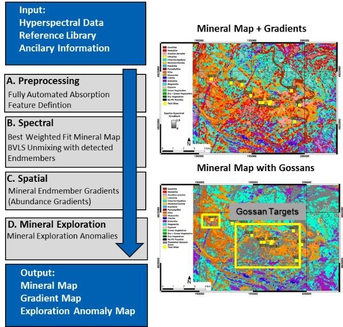
study site!Bare Earth mapping: Geological and soil applications
Improved EnGeoMAP and EnSoMAP processors for mineral and soil
mapping implemented in the EnMAP-Box software (new release End 2019)
Simulation of EnMAP products for mineral and soil mapping
Simulated EnMAP product
for bare soil mapping
Mielke et al.: EnGeoMAP processor Chabrillat et al.: EnSoMAP processor Steinberg et al.,
for geological mapping with EnMAP for digital soil mapping with EnMAP Rem. Sens. 2016
See session 3a Hypersp. Erdbeob.Vegetation applications
Pacheco-
Simulated EnMAP products Labrador et al.
Agriculture: Natural ecosystem: Forest:
EnMAP vegetation Quantitative vegetation Nutrient deficiency
processor cover mapping mapping
Canopy Liquid Water Content Fractional Cover, CA, N concentration at
(EWT), estuary of the Ems Okujeni et al. Donnersberg, RLP,
river, Wocher et al. Buddenbaum et al.
See session 3a Hypersp. Erdbeob.Water ressources, Ice and snow applications
Coastal & inland waters: Cryospere physical properties:
EnMAP water products EnMAP snow products
Algorithms based on Painter
et al 2003; 2013; 2016:
Snow grain size (microns),
broadband albedo, radiative
forcing
Discrimination of phytoplankton NASA US Project. Principal
groups, Hieronymi et al. Investigator: Thomas H.
Painter, UCLA
See session 3a Hypersp. Erdbeob.HYPERedu
Development of an online learning platform for imaging
spectroscopy as part of the EnMAP education initiative
Presentations, tutorials and educational films on principles,
methods and applications of imaging spectroscopy
Addressed at students and professionals at master level
First teaching courses published online September 2019
Massive Open Online Course (MOOC) with several modules
and certificates planned 2021
Hosted at EO College platform
eo-college.org
Foerster et al.
See session 2b EO-EducationSynergies with other missions for science applications
Multispectral: operational, global coverage, high spatial resolution and revisit time
Hyperspectral (EnMAP): scientific, site-oriented („snapshots“), high potential for
material identification and quantification through spectral information
Multispectral: Change magnitude Hyperspectral: Salt crust mineralogical
Omongwa salt pan (Namibia)
map based on 30y Landsat archive map based on Hyperion (09/2014).
(1984-2015)
Milewski et al., Rem. Sens. 2017International collaboration and synergies with other spaceborne imaging spectroscopy missions: ‘Target’ missions DESIS (DLR Germany & Teledyne USA) 400-1000 nm, 3.3 nm resolution ~30m GSD & ~30 km swath, lat. ~
International collaboration and synergies with other spaceborne
imaging spectroscopy missions: ‘Mapping’ missions
Next-generation Landsat- and Sentinel- hyperspectral missions in preparation
HyspIRI/SBG: Surface Biology and Geology (NASA JPL / GSFC USA)
NASA priority after 2017 Earth Science Decadal Survey
Designated observable study plan
380-2500 nm, ~5-15 nm resolution + TIR bands
30-45m / 60-100m GSD, 8-16 days
Courtesy D. Schimel, 2019
CHIME : Copernicus Hyperspectral Imaging Mission for the Environment (ESA)
One of 6 High-Priority Copernicus Missions
In Phase A/B1
400-2500 nm, ≤10 nm resolution
20-30m GSD, 10-15 days
Time frame ~>2024-26
Courtesy M. Rast, 2019EnMAP community activities
www.enmap.org/flights
YoungEnMAP: international
summer schools and workshops
12th EARSeL SIG Imaging Spectroscopy
Workshop, 22-25 March 2021 in Potsdam
(jointly organized GFZ Potsdam / HU Berlin)Summary: Mission status
EnMAP Platform and instrument are being integrated at
OHB Oberpfaffenhofen
(Courtesy OHB)
After solving a major design problem, the SWIR cameras
have been integrated and characterized in the instrument
Pre-launch characterisation campaign has started
Ground-segment in testing phase at DLR Oberpfaffenhofen
(Neustrelitz, Berlin)
Development of a suite of tools and algorithms for
the scientific exploitation of EnMAP data
EnMAP with its open data policy will be an important
contributor to the provision of EO data with high
spectral resolution
Launch: 1st half 2021
Thank you for your attention!You can also read