What's missing in geographic parsing? - Advances and Challenges of Geographic Analysis of Text with Application to Disease Monitoring - World ...
←
→
Page content transcription
If your browser does not render page correctly, please read the page content below

What’s missing in geographic parsing?

Advances and Challenges of Geographic Analysis of Text with Application to
Disease Monitoring

13th November 2019

Nigel Collier
nhc30@cam.ac.uk

About the Language Technology Lab

Working on fundamental and applied
Natural Language Processing,
including:

•   Information extraction
•   Machine learning
•   Machine translation
•   Resources and evaluation
•   Text generation
•   Sentiment analysis
•   Social media
•   Health applications
                                     Thanks to: Milan Gritta, Taher Pilehvar and Jens
                                     Linge (JRC)
                                     Supported by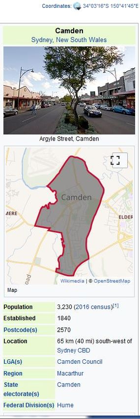
Summary of main points

• Epidemic detection from news is a challenging task that will benefit from
  advances in methods-based research and open source data/software.

• Today we’re focussing on Geo-parsing:

  • Geo-parsing is the identification of place names (toponyms) in text and their
    linking to unique identifiers in a databases;

  • Toponym disambiguation on a global scale at granular levels is still a great
    challenge;

  • Need for open standards to compare approaches and involve technical
    community;

  • Progress with new datasets, neural network models and a taxonomy of
    toponyms.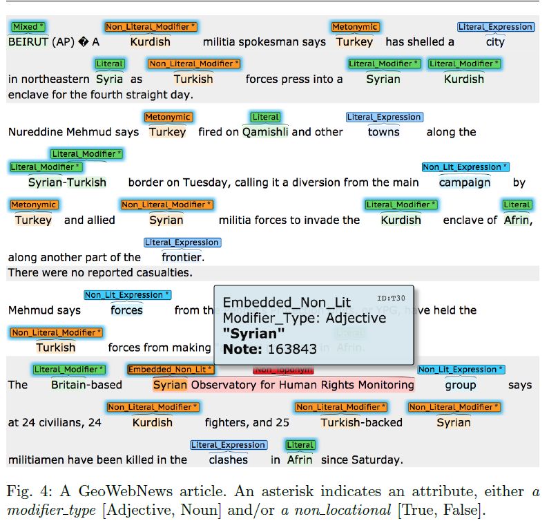
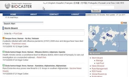
Experience on epidemic detection with BioCaster (2006-2012)
                                                      Ontology browsing
                                       Trend graphs   Email/GeoRSS alerting
                                                      Watchboard, etc.
Event database search

    Up to date news in                                   Event summaries
    12 languages

WHO                      US
EU        GHSI           UK
IT       partners        FR
JP                       DE
CA

             Event alerts

                              Real time Twitter
                              analysis
Multiple technical challenges raised (2006-2012)

• Geographic parsing

• Trustworthiness of sources (veracity detection)

• Symptom coding (e.g. to ICD-10, SNOMED CT)

• …
Practically speaking there’s no event without time and space

                                                            Natural Language
                                                               Processing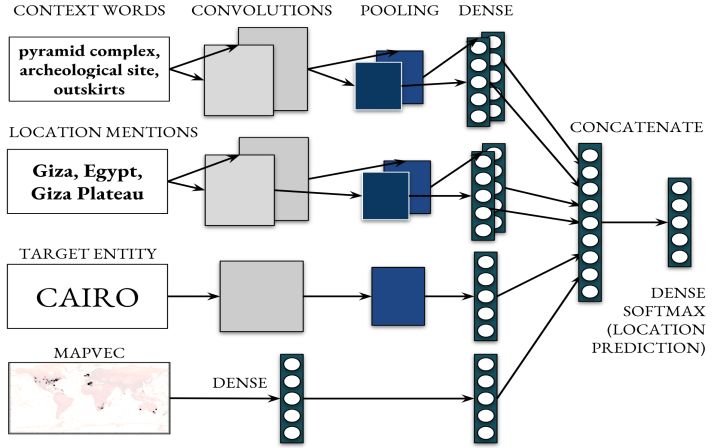
The consequences of getting geoparsing wrong

 Equine flu: more horses diagnosed        Equine flu: more horses diagnosed
 in Camden                                in Camden

                                     vs

              UK ?                                     Australia ?
The benefits of getting geoparsing right

                                            Equine flu: more horses diagnosed
                                            in Camden

             Coordinates:
             34° 3′ 16″ S, 150° 41′ 45″ E

             Population:
             3,230 (2016 census)

             Location:
             65 km south-west of Sydney
Geoparsing: a two step approach

Equine flu: more horses diagnosed in Camden

                     1.              2.
    Text
                 Geotagging       Geocoding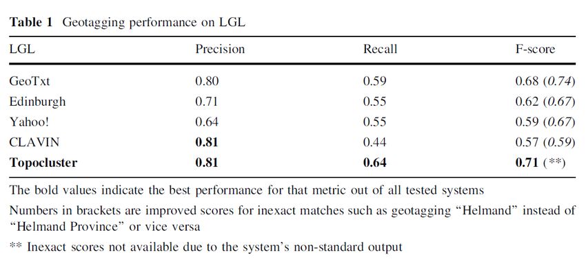
Geoparsing: a two step approach

Equine flu: more horses diagnosed in [Camden] LOCATION

                      1.                2.
    Text
                  Geotagging         Geocoding
Geoparsing: a two step approach
Equine flu: more horses diagnosed in [Camden]34°3′16″ S,150°41′45″E
1. 2.
Text
Geotagging GeocodingGeoparsing: a two step approach
Equine flu: more horses diagnosed in [Camden]34°3′16″ S,150°41′45″E
Document-
1. 2.
Text level
Geotagging Geocoding
geocodingGeoparsing: a two step approach
Equine flu: more horses diagnosed in [Camden]34°3′16″ S,150°41′45″E
Document-
1. 2.
Text level
Geotagging Geocoding
geocodingThe landscape of geotaggers/coders Edinburgh geoparser [1] – fully rule-based using local context, spatial clustering and user locality with lists from Wikipedia and Geonames; CLAVIN [2] – rule based using local context and population priors; Yahoo! Placemaker [3] – unknown; GeoTxt [4] – rule-based using local context, approximate string matching and population size; Topocluster [5] – geo-language model using lexical features; [1] Grover, C., Tobin, R., Byrne, K., Woollard, M., Reid, J., Dunn, S., & Ball, J. (2010). Use of the Edinburgh geoparser for georeferencing digitized historical collections. Philosophical Transactions of the Royal Society of London A: Mathematical, Physical and Engineering Sciences, 368(1925), 3875-3889. [2] https://clavin.bericotechnologies.com [3] https://developer.yahoo.com/geo/ [4] Karimzadeh, M., Huang, W., Banerjee, S., Wallgrün, J. O., Hardisty, F., Pezanowski, S., ... & MacEachren, A. M. (2013, November). GeoTxt: a web API to leverage place references in text. In Proceedings of the 7th workshop on geographic information retrieval (pp. 72-73). ACM. [5] DeLozier, G., Baldridge, J., & London, L. (2015, January). Gazetteer-Independent Toponym Resolution Using Geographic Word Profiles. In AAAI (pp. 2382-2388).
Rigorous evaluation needs open data standards …

 • War of the Rebellion corpus [6] - historical texts

 • Wallgrün’s Twitter corpus [7] - tweets

 • TR-CONLL [8] – news data, proprietary

 • ACE 2005 English SpatialML corpus – news data, fee-based

 • Local Global Corpus (LGL) [9] – local news sources around the
   world

 [6] DeLozier, G., Wing, B., Baldridge, J., & Nesbit, S. (2016, August). Creating a novel geolocation corpus from historical texts. In Proceedings of
 the 10th Linguistic Annotation Workshop held in conjunction with ACL 2016 (LAW-X 2016) (pp. 188-198).
 [7] Wallgrün, J. O., Hardisty, F., MacEachren, A. M., Karimzadeh, M., Ju, Y., & Pezanowski, S. (2014, November). Construction and first analysis
 of a corpus for the evaluation and training of microblog/twitter geoparsers. In Proceedings of the 8th workshop on geographic information
 retrieval (p. 4). ACM.
 [8] Leidner, J. L. (2006). An evaluation dataset for the toponym resolution task. Computers, Environment and Urban Systems, 30(4), 400-417.
 [9] Lieberman, M. D., Samet, H., & Sankaranarayanan, J. (2010, March). Geotagging with local lexicons to build indexes for textually-specified
 spatial data. In 2010 IEEE 26th international conference on data engineering (ICDE 2010) (pp. 201-212). IEEE.
WikToR: a new gold standard corpus

 • Designed to test system’s ability to disambiguate place names

 • 5000 Wikipedia pages containing highly ambiguous place names
   selected according to the GeoNames database, e.g.

      • Santa Maria (26 entries), Santa Cruz (25 entries), Victoria (23
        entries), Lima (19 entries), Santa Barbara (19 entries)

 • 200 words for each page to provide context, including the ambiguous
   place name.

 • Ambiguous place names are at least 1000km apart so any mistake by
   the system is judged to be costly.

 [10] Gritta, M., Pilehvar, M. T., Limsopatham, N., & Collier, N. (2018). What’s missing in geographical parsing? Language Resources and
 Evaluation, 52(2), 603-623.
Geotagging performance on the LGL corpus [10] Gritta, M., Pilehvar, M. T., Limsopatham, N., & Collier, N. (2018). What’s missing in geographical parsing? Language Resources and Evaluation, 52(2), 603-623.
Geocoding performance on the LGL corpus

 [10] Gritta, M., Pilehvar, M. T., Limsopatham, N., & Collier, N. (2018). What’s missing in geographical parsing? Language Resources and
 Evaluation, 52(2), 603-623.
Geocoding performance on the WikToR corpus

 [10] Gritta, M., Pilehvar, M. T., Limsopatham, N., & Collier, N. (2018). What’s missing in geographical parsing? Language Resources and
 Evaluation, 52(2), 603-623.
Take homes

• A great geo-parser must excel in

  • Speed (e.g. CLAVIN)

  • Geotagging accuracy (e.g. Topocluster)

  • Geocoding performance (e.g. Yahoo!)

• We’re not there yet.
Better geocoding with deep neural networks (CamCoder)

                     CamCoder [11]: a state of the art scores on for place
                     name disambiguation on three datasets (Local Global
                     News, WikToR and GeoVirus)

                     [11] Gritta, M., Pilehvar, M. T., & Collier, N. (2018, July). Which melbourne? augmenting
                     geocoding with maps. In Proceedings of the 56th Annual Meeting of the Association for
                     Computational Linguistics (Volume 1: Long Papers) (pp. 1285-1296).

                                                                                                A baseline that
                                                                                                chooses the most
                                                                                                populace location
Drilling down False Positives can be misleading when doing fact extraction: • Metonymy - Moscow negotiates with Seoul. • Homonymy - Milan told me a story. • Languages - She can speak Spanish and Russian. • Demonyms - A Japanese walks into a bar. False Negatives are often neglected during fact extraction: • Coercion - Meeting is held at the United Nations. • Embedded Toponyms – Athens Festival of Food starts tomorrow. • Modifiers – The target is to reach the Canadian border.
A pragmatic taxonomy of toponyms

                               Data from the GeoWebNews corpus:
                               200 news articles from the European
                               Media Monitor

                               [12] Gritta, M., Pilehvar, M. T. and Collier, N. (2019) “A pragmatic
                               guide to geoparser evaluation” in Language Resources and
                               Evaluation. Published online at https://doi.org/10.1007/s10579-019-
                               09475-3
A pragmatic taxonomy of toponyms
Data from the GeoWebNews corpus:
200 news articles from the European
Media Monitor
[12] Gritta, M., Pilehvar, M. T. and Collier, N. (2019) “A pragmatic
guide to geoparser evaluation” in Language Resources and
Evaluation. Published online at https://doi.org/10.1007/s10579-019-
09475-3Review
Importance of:
• Methods based research to support epidemic intelligence
• Open source data sets/software for open evaluations and reaching out to
technical communities
• Geo-parsing using neural network language models
• Understanding types of toponym mentionsThank you! https://sites.google.com/site/nhcollier/ nhc30@cam.ac.uk ORCID: 0000-0002-7230-4164 Twitter: @nigelhcollier
You can also read