Environmental analysis of lower Jordan Creek 1987 - Juneau Nature
←
→
Page content transcription
If your browser does not render page correctly, please read the page content below

ENVIRONAID

    Environmental analysis of
    lower Jordan Creek and
    nearby wetlands in regard
    to planned airport
    taxiway extension

    Daniel Bishop
    Robert Armstrong
    Richard Carstensen

    July 31st, 1987

1   •   Environmental analysis of lower Jordan Creek ● 1987       Bishop, Armstrong & Carstensen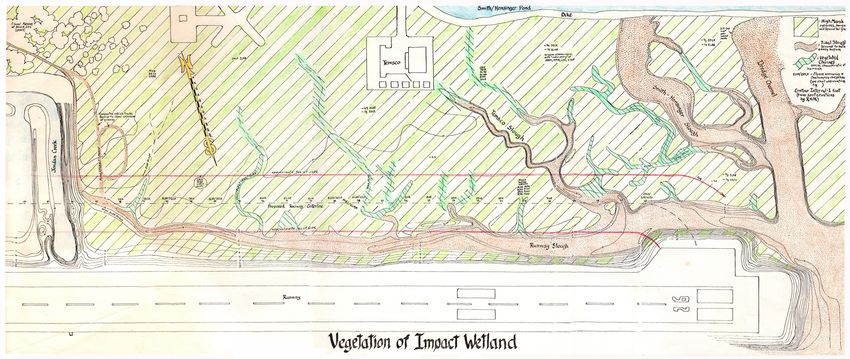
Environmental analysis of lower Jordan Creek and nearby
wetlands in regard to planned airport taxiway extension.                                                                                                                                  Cover: Bob Armstrong preparing to seine a tidal
                                                                                                                                                                                            slough in Impact Wetland, summer, 1987
Contents
Summary.....................................................4                                   Impact Reach...................................................................25
 Impact reach........................................................ 4                       Mammals............................................................ 25
 Impact pond......................................................... 4                      Results & discussion: Impact Wetland..26
 Impact Wetland.................................................... 4                         Hydrologic conditions...................................... 26
Objectives...................................................5                                  Fresh water outflows through Impact Wetland............26
                                                                                                Gradients of intertidal channels....................................26
Scope of work.............................................5                                     Post-glacial rebound ......................................................26
Background.................................................6                                    Tidal flows at Impact Wetland........................................28
 Hydrology............................................................. 6                       Surface sediments..........................................................28
 Vegetation............................................................ 7                       Tidal scour versus uplift.................................................29
 Fish....................................................................... 7                Vegetation.......................................................... 29
                                                                                                Classification of marsh vegetation ...............................30
 Birds....................................................................11                    Low marsh.......................................................................30
Methods ....................................................11                                  High marsh.......................................................................31
 Hydrology ...........................................................11                        Vegetated sloughs...........................................................31
 Vegetation...........................................................11                        Halophytes and sedimentation......................................33
 Fish......................................................................11                   Production and outflow of food.....................................34
                                                                                                Slough habitats...............................................................34
 Birds................................................................... 12
                                                                                              Fish and wetland channel habitats ................. 35
Results & discussion: lower Jordan......12                                                      Starry flounder and staghom sculpin ...........................35
 Hydrologic conditions...................................... 12                                 Capelin and Pacific herring ...........................................35
    Freshwater outflows.......................................................13                Pacific sand lance...........................................................35
    Ground water flows.........................................................14               Salmonids........................................................................35
    Gradient and channel conditions..................................15                       Birds of Taxiway wetlands................................ 36
    Tidal flow .........................................................................16      Canada geese..................................................................36
    Jordan water quality.......................................................16               Mallards............................................................................36
    Impact Pond water quality..............................................16                   Shorebirds.......................................................................36                                                            Pool on Jordan Creek just before runway culvert,
 Vegetation.......................................................... 17                        Songbirds ........................................................................36
                                                                                                                                                                                         Preface 2021: This 1987 Environaid report
                                                                                                                                                                                                                                                 also shown in distance of Photo 1, next page.
    Crest Avenue and Impact reaches.................................17                          Postscript 2021: Birds and plane safety.......................36                         has been scanned, OCR'd and reformated.              Area used by adult salmon and smolts for resting.
    Vegetation of Impact Pond & Margins...........................18
    Vegetation of Yandukin Drive Reach.............................18
                                                                                             Impacts......................................................37                             Text is unaltered except for minor correc-                               Maximum depth about 5 feet.
 Fish and their habitats ..................................... 19                             Impact Pond ...................................................... 37                      tions. A few postscript comments have been
    Salmonids........................................................................19       Impact- & Crest Avenue reaches..................... 37                                     added as footnotes so as not to intrude on         distributed only as appendix to the formal
                                                                                              Impact Wetland ................................................. 37
    Capelin ............................................................................19
                                                                                                                                                                                         'historical' character of the document.            EA (Environmental Assessment) by a Colo-
    Pacific sand lance ..........................................................19          Recommendations...................................37                                                                                           rado airport-advocacy firm that downplayed
    Pacific herring ................................................................19        Improvements, Crest Avenue Reach............... 37                                             In one case, a 2020 orthophoto has
    Pacific staghorn sculpin.................................................19
                                                                                              Reduced Impact Pond & adjoining dike.......... 38                                          been added as page-flipper against 1986,           projected impacts and did literally no boots-
    Starry flounder ................................................................19
    Three-spined stickleback ..............................................19                 Pond-loss mitigation......................................... 38                           showing changes subsequent to this study.          on-ground work in Áak’w Aaní. Nonethe-
    Coast range sculpin........................................................19             Wetland north of new taxiway.......................... 38                                  Some, such as taxiway extension, had been          less, for staff of Fed/State/City permitting
    Impact Pond ....................................................................20        Wetland-loss mitigation ................................... 38                                                                                agencies, the Bishop-Armstrong-Carstensen
    Impact Reach...................................................................21         Other mitigation considerations...................... 39                                   proposed at the time of our work. But most
 Crest and Yandukin Reaches........................... 21                                                                                                                                have been additions to airport facilities we       appendix became a standard "desktop
                                                                                             Acknowledgements..................................39
 Birds of lower Jordan Creek............................ 22                                                                                                                              could not foresee in 1987.                         reference"—in predigital meanings of that
                                                                                             Literature cited.........................................39
    lmpact Pond.....................................................................22
                                                                                                                                                                                             Dan Bishop's report was printed and            term: literally, a printed copy, close at hand

2       •      Environmental analysis of lower Jordan Creek ● 1987                                                                                                                                                                                Bishop, Armstrong & Carstensen
Context for the 1987
                                                                                                          Environaid study

                                                            Alaska, from way over 30,000 feet—
                                                                                                         folder in one of the 20-pound boxes, I finally located a completely intact copy.
     Dan Bishop, 1980s. Scanned                             neglected to mention that all envi-
    from a print in Environaid files.                                                                    Alongside it were original B&W photos from Dan's medium-format Hasselblad,
                                                            ronmental content was Environaid's.
          "From Dan I learned to                                                                         and my handcolored maps, that'd been too expensive (or politically inconve-
                                                            The Improvements cover bore scant
       dig holes, sniff sulfur, slurp                                                                    nient?) to include in the printed reports.
       through horsetail marshes,
                                                            promise of utility to anyone tasked
                                                                                                            At Discovery, our goal is to ultimately scan and digitize the entire, price-
       take pictures hanging from                           with objectively evaluating project
                                                                                                         less, Environaid report collection. OCR (optical character recognition) may
       tree limbs, turn over rocks,                         consequences for fish, birds or plants.
                                                                                                         be impractical for most of them because Dan & Beth's early dot-matrix printer
        hack survey lines through                           I, myself, 34 years later, almost threw it
     willow thickets, roll mud in my                                                                     cranked out blotchy letters inducing ~2 typos per line. My app mistakes a for
                                                            out, but fortunately opened to Appendix
     fingers, and then write about                                                                       e, and l for 1. But for this key report it was worth the 4 days of re-assembly
                                                            A: Supporting documentation. Ahah! So
     it." Streamwalkers, Discover-                                                                       and proofing. I've enjoyed reliving those often-hilarious outings with Dan and
              ies, Fall 1996.
                                                            that's where Bishop et al was hiding!
                                                                                                         Bob, and hope you'll forgive the remaining, more-than-occasional bloopers.
                                                               Bob and I still get several requests
                                                                                                            Dan Bishop introduced me to environmental consulting as one hopes it
                                                            per year—from elder scientists or
                                                                                                         might function, unbeholden to client or clique. I hope you find Environmen-
on their desks. We were often thanked by these biologists   younger folks who heard rumors of
                                                                                                         tal analysis of lower Jordan Creek helpful in your wetland ambles, your
and administrators for documenting baseline environmental   this study's existence. But until Dan's
                                                                                                         research, or your management decisions. Or, perhaps, in your advocacy:
conditions essential to their work on the Wetlands.         daughters Gretchen and Brita brought
                                                                                                            "not for your team or campaign or employer, but for wildness, the highest
   But as those biologists reshuffled or retired, copies    by half a carload of 30-year-old+
                                                                                                         intellectual quest." —— UAS Commencement address, May, 2019
disappeared, including my own. One reason is that the       Environaid records, I've been unable
                                                                                                                                   Richard Carstensen, October, 2021
cover—featuring a jet descending toward the map of          to share this gem. In a folder within a

3     •    Environmental analysis of lower Jordan Creek ● 1987                                                                                   Bishop, Armstrong & Carstensen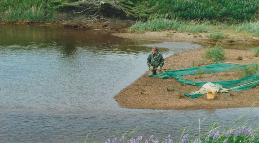
Summary
                                                        Impact Pond
The area of study is adjacent to Juneau lnternation-
al Airport just above the mouth of Jordan Creek, or     The taxiway will fill more than half of the 7.25 acre
adjacent to the northeast corner of the runway. The     pond now connected to lower Jordan Creek (Impact
portion of the stream in question is about 3,000        Pond). Probable lowering of the grade of Crest
feet in length; the wetland area where the extended     Avenue Reach after installing the new airport culvert
taxiway would be located is also about 3,000 feet       (about 1.5 to 2 feet might be expected) will drain most
long.                                                   of the remaining shallow pond except deep holes that
                                                        lie most distant from the pool's mouth. Ditchgrass
Impact Reach                                            beds of Impact Pond provide valuable habitat for
                                                        epiphytes, invertebrates, stickleback, and sculpin,
Taxiway construction will fill and culvert a section    which are the basis for large and varied numbers of
of lower Jordon Creek immediately upstream of           waterfowl that use this area. The pond also provides
the runway about 250 feet in length, leaving about      resting or holding areas for adult coho salmon and
250 feet of existing channel upstream to the first      Dolly Varden that return to this stream. Complete
90o elbow and about 100 feet downstream to the          mitigation for loss of this pond is difficult; we have
runway culvert. This area to be altered is called       suggested some partial mitigation measures.
Impact Reach (Photo 1). Approximately 300 feet
of the channel to be altered immediately above the      Impact Wetland
existing airport culvert contains productive fish
habitat, with a deep pool and with clean gravels        Twenty-five acres of wetland and intertidal chan-
and sands.                                              nel will be taken by the taxiway fill. This salt marsh
   Upstream of that section, the channel bed of         wetland is a relatively high and protected intertidal
Impact Reach is filled with silty muck, which           area and consequently its surfaces (predominantly
persists to within 50 feet of Crest Avenue culvert.     above 16 feet) are vegetated mostly with grasses. The
This slow-flowing, very low gradient, 30- to 50         higher intertidal channels, however, support such key
feet-wide channel, is relatively poor fish habitat.     waterfowl vegetation as Lyngbye sedge, goosetongue,
We believe that habitat quality of this stream sector   and arrowgrass. Both the grass stands and the lower
(Crest Avenue Reach, Photo 3) could be enhanced         intertidal plants trap algae and detritus on higher tides,
by planned lowering of the airport culvert in
conjunction with work to confine and to vary the          Photo 1: Impact Reach. Downstream from 90o bend in
flow route, narrowing the stream's normal channel,      Jordan Creek, runway culvert in distance. Heavy deposi-
and stimulating overhanging banks and pools.                 tion, little cover for fish. High water, June 26, 1987.

4   •   Environmental analysis of lower Jordan Creek ● 1987                                                            Bishop, Armstrong & Carstensen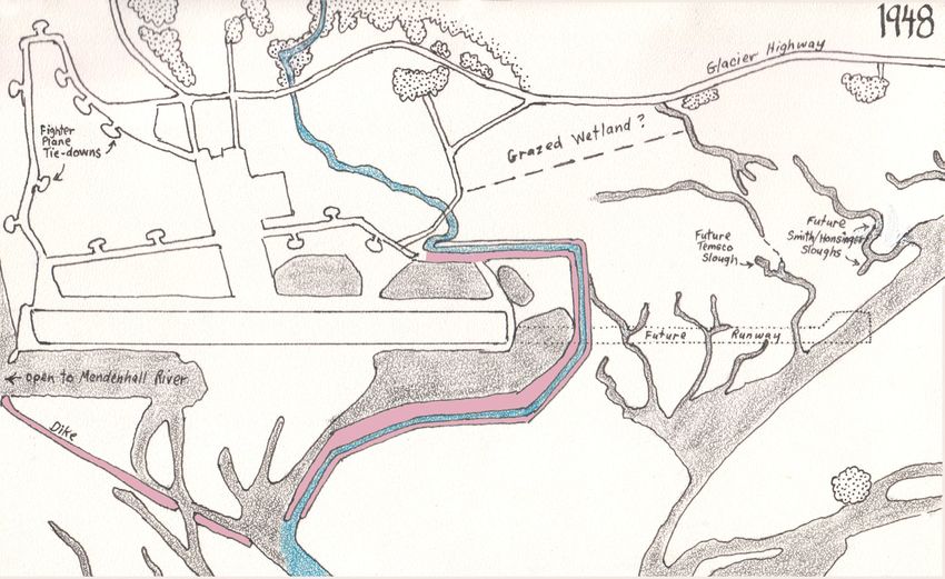
upland meadow system within the next several decades, in
                                                                                                                          part because it's relatively barricaded from tidal action.

                                                                                                                          Objectives
                                                                                                                          The first purpose of this work is to describe the fish and
                                                                                                                          wildlife populations, habitats, and land and water conditions
                                                                                                                          that now exist in areas that will be affected by the planned
                                                                                                                          project. The relationships developed during this phase of work
                                                                                                                          are then used to evaluate changes in habitats that may result
                                                                                                                          from the project. Finally, recommendations are provided for
                                                                                                                          minimizing project impacts, protecting or improving habitats
                                                                                                                          through features of project design, and for mitigation of values
                                                                                                                          impacted by the projected construction.

                                                                                                                          Scope of work
                                                                                                                          All field work for this study was done on Jordan Creek below
                                                                                                                          Yandukin Drive and on the wetamds between lower Jordan
                                                                                                                          Creek and east end of the runway. Within the lower Jordan
                                                                                                                          Creek system, emphasized areas were:
                                                                                                                            ● the straight reach between Crest Avenue culvert and the
                                                                                                                          downstream right angle turn in the channel (here called Crest
                                                                          Photo 2: View east across northern half of      Avenue Reach)
                                                                           Impact Pond. Young spruce on WWII-era            ● the reach of Jordan Creek immediately upstream of the
                                                                          dike. Water depth ranges from 1.5 to 3 feet,    Airport culvert which would be eliminated by taxiway fill and
                                                                               with one 8-foot hole in foreground.
                                                                                                                          culvert (here called Impact Reach) and the connecting Jordan
and provide the food base and the intertidal flow routes        stable and fertile channels farther upstream in the       Creek Pond (called Impact Pond). 1
that drain the area.                                            flood tide's route, such as the channel that leads from     ● The reach of Jordan Creek between Yandukin Drive and
   We found the intertidal channels, in general, to support     Temsco heliport. The large channel leading to the         Crest Avenue culverts (here called Yandukin Drive Reach)
a diverse and valuable variety of invertebrate and fish life.   outlet of Smith-Honsinger Pond (marginal to Impact        1 PS 2021: Can't remember who came up with those names: Impact Pond,
The large channel nearest to the runway appeared least          Wetland) is a particularly productive system.             Impact Reach, Impact Wetland. Probably me, the snippy one. Signalling our
                                                                   Impact Wetland system is likely to become an           refusal to softpedal environmental losses, these names were one reason
productive, but provided tidal access to smaller, more
                                                                                                                          our work was ultimately relegated to Appendix in the EA.

5   •   Environmental analysis of lower Jordan Creek ● 1987                                                                                            Bishop, Armstrong & Carstensen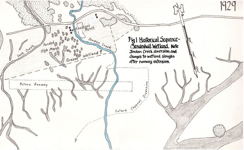
was also examined in sufficient detail to provide an      mapping was developed.
                                                         adjacent hydrologic and biologic standard where              The project was under the overall leadership of
                                                         good quality habitat conditions prevail (Photo 3). On     D. Bishop. Field work was completed cooperatively
                                                         wetlands adjacent to the northerly side of the runway,    by the study team. R. Armstrong supervised fish
                                                         the work was concentrated on the area to be filled by     and bird observations and measurements. D. Bishop
                                                         the taxiway, (here called Impact Wetland), and includ-    was responsible for hydrologic investigations, and
                                                         ed observations on intertidal habitats and populations,   R. Carstensen did the cartographic and vegetative
                                                         and of wetland vegetation patterns.                       work, assisted with fisheries and wildlife work, and
                                                            Our investigations did not include attempts to         with hydrology-related examinations of postglacial
                                                         document recreational values of the study areas, or to    rebound and intertidal channel flows. Recommenda-
                                                         evaluate the visual attributes of the area. We believe    tions contained in this report were developed jointly
                                                         that an appreciation of these values can be derived       by the study team and summarized by study team
                                                         from the recently completed CBJ Wetland Study, in         leader Bishop.
                                                         particular, the public survey information contained in
                                                         that report. (Adamus, et al. 1987)
                                                            Greater attention was given in this study to fish
                                                                                                                   Background
                                                         and birds than to mammals or invertebrates. Mammal        Hydrology
                                                         information seemed less critical than birds or fish.      Prior to the City and Borough of Juneau Wetland
                                                         While invertebrates form a critical basic part of the     Study (Adamus et al. 1987), U.S. Geological survey
                                                         food chain of these waters, we did not attempt a thor-    had made a few miscellaneous observations of the
                                                         ough inventory in the limited time available.             quantity and quality of waters in the Jordan Creek
                                                            This environmental work was begun in early March       drainage. This work was done in the mid-1960's as
                                                         of 1987 and continued into July of 1987. In addition to   part of a Juneau water study in association with the
                                                         our field observations, we have also used the observa-    C/B of Juneau and did not include flow or water
                                                         tions and measurements of agencies and individuals        quality observations as far downstream as our area
                                                         who have worked in the study area at other seasons of     of study. In the course of fisheries investigations
                                                         the year. Photography, mapping and vertical control       several biologists made water quality observations in
                                                         data developed by R&.M Engineering provided the           Jordan Creek, including the lower stream. The water
                                                         control from which our additional environmental           temperature work of Sheridan and Bloom in 1975 is
                                                                                                                   relevant to this work.
                                                         Photo 3: Downstream on Crest Avenue Reach from
                                                         Crest Ave culvert. Just beyond island in foreground
                                                                                                                      The Mendenhall Valley Drainage Study, complet-
                                                         Jordan Creek becomes sloughlike, with 1 to 2 feet of      ed by EMPS in 1979, included work on the Jordan
                                                         muck. Little cover for fish. High water, June 26, 1987.   Creek drainage, primarily as related to stormflows,

6   •   Environmental analysis of lower Jordan Creek ● 1987                                                                        Bishop, Armstrong & Carstensen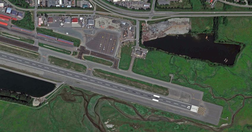
flood levels and adequacy of culverts. The most recent summary of local salt marsh vegetation types ond
study of wetlands of the Mendenhall Valley and other successional processes.
areas surrounding the Mendenhall Wetlands Refuge
included much work along the length of Jordan Creek Fish
and is used here. The high fish value of Jordan Creek has been
documented many times in the past (Bethers and
Vegetation Munk 1976). For coho, population estimates of
John Crow did the only quantitative assessment of juveniles have revealed some of the highest figures
vegetative types on the Mendenhall wetlands, at some ever recorded for a stream in southeastern Alaska
time prior to 1967. His work has apparently never been (ADF&G memo from Elliott to Bethers on Aug.
published. We have only a draft of his preliminary 6, 1983). In a recent study of Juneau area streams
reconnaissance, with frequency and percent cover data one section of Jordan Creek was found to have
for 24 salt marsh plants, divided into 10 community the second highest density of wintering juvenile
types according to dominant species. Without knowl- coho of all streams sampled (Adamus et al 1987).
edge of his methods and plot locations, these data could This same study found the highest density of Dolly
not be used. Varden juveniles, of any Juneau stream, wintered in
Sarah Watson (1979) provided Alaska Department a section of Jordan Creek.
of Fish and Game with qualitative descriptions of Despite a considerable amount of documented
bird habitats on the Mendenhall Wetlands. Her report information on importance of Jordan Creek to
included a species list of plants of the Mendenhall salmonids very little information existed on fish
Wetlands by Robert Armstrong. A vegetation map of values in downstream areas below Crest Avenue
the wetlands was drafted by ADF&G Habitat division culvert. In a summary of recent juvenile fish trap
in 1984, at a scale of 1"=500', based upon Watson's data for Jordan Creek, Bethers and Munk (1967)
work. Unfortunately this map is inaccurate for our mentioned only one minnow trap survey below
study area north of the airport runway (see Impact Yandukin Drive (catches below Crest Avenue
Wetland>Vegetation). culvert were not given). We found one note in the
Cathy Stone (1963) did PhD research on intertidal ADF&G files where 9 traps were set for 2.5 hours
wetlands of the Juneau area. Her thesis offers the best on Feb 16, 1984 from Crest Avenue culvert to
Airport runway culvert. Only one coho juvenile
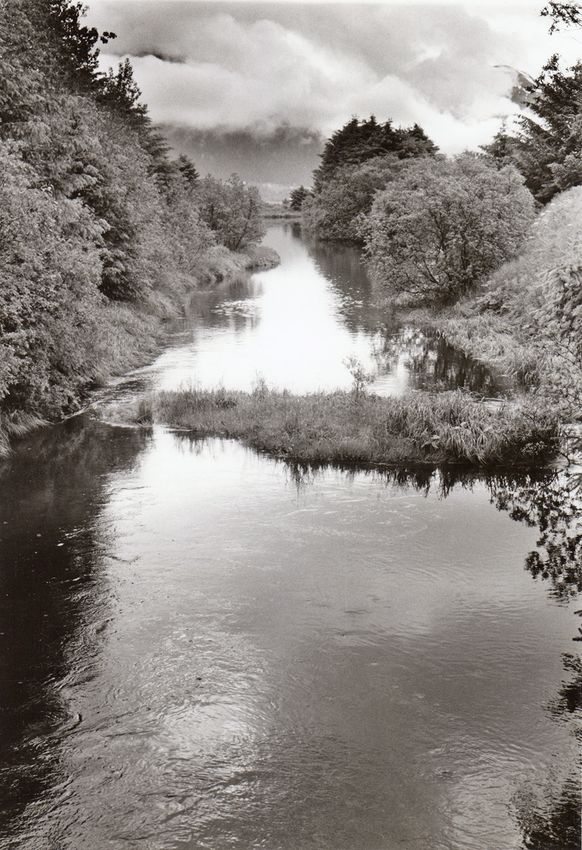
Photo 4: Yandukin Drive Reach, above Crest Avenue was obtained on this survey.
Reach and below Yandukin Drive. Stream has gravel Two conclusions can be drawn from this back-
substrate, is much more confined, and has more cover ground information: 1) Jordan Creek is one of the
for fish than downstream portion. text continues on page 10
7 • Environmental analysis of lower Jordan Creek ● 1987 Bishop, Armstrong & Carstensen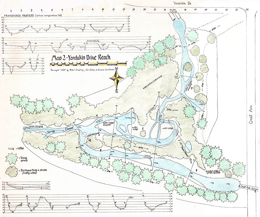
Fig 1
Pageflipper
series: Map 1 of 3.
Placed identically
to maps on next 2
pages. Toggle in
Acrobat Reader
for point-to-point
comparison.

Traced from US
Navy aerial shot
from amphibious
biplane. Mission
was flown prior to
first wheelplane
landings on a
grass runway
here in the 1930s.
Sinuous, natural
paths of Duck and
Jordan Creeks
suggest converg-
ing flows across
future runway
belt, indicated by
discontinuous,
probably dendritic
channels barely
showing on the
photo.

8   •   Environmental analysis of lower Jordan Creek ● 1987   Bishop, Armstrong & Carstensen

Pageflipper
series: Map 2 of
3. Traced from
post WWII Navy
aerials. Rapid
wartime construc-
tion created many
future problems for
airport managers,
such as dredge
ponds attracting
'dangerous' birds
near the runway.
   Pink shows
constraining dikes
that routed Jordan
Creek around the
incipient floatplane
basin and other
dredgings for
massive quantities
of fill required by
runway and taxi-
way construction. 1

1 PS 2021: The
original EA, to
which this report
was Appendix
A, contained a
letter from R&M
recommending
Jordan Creek be
placed back within
these constraining
dikes.

9    •   Environmental analysis of lower Jordan Creek ● 1987   Bishop, Armstrong & Carstensen
Pageflipper
series: Map 3 of
3. Traced from a
1986 R&M aerial.
Principle sectors
of our study area
labeled.

10   •   Environmental analysis of lower Jordan Creek ● 1987   Bishop, Armstrong & Carstensen
most important salmonid streams in the Juneau area         Instruments Model 33 SCT meter. Determinations of               compared with current photography to assess changes in
and one that deserves all the protection we can give it,   thickness of muck in lower Jordan Creek were made in            wetland channels and associated vegetation (Fig 1). This
and 2) lack of information on the lowermost portion        late winter on the channel ice. Sediment measurements           provided an indication of rate and direction of succes-
meant that we needed to especially concentrate our         in Impact Pond were made with boat, auto-level and rod.         sional change.
efforts on determining fish use of this area.              Stream profiles in lower Jordan Creek were made with auto-
                                                           level and rod. Intertidal channel profiles were derived from    Fish
Birds                                                      R&M topographic information.                                    Fish were visually counted, seined, minnow-trapped and
Seasonal occurrence of birds on the Mendenhall                Numerous visits were made to the stream, pond and            measured from early March through mid-July in Jordan
Wetlands has been documented by Armstrong and              wetland during the course of hydrologic as well as fisher-      creek from Yandukin Drive downstream to the runway
Glass (1986) and Watson (1979). Most important,            ies investigations. Flow and pond conditions were seen in       culvert including Impact Pond, connected to Jordan Creek
however. was survey work done by US Fish and Wild-         conditions ranging from late winter with ice on the stream to   below Crest Avenue. In addition, fish were visually noted,
life Service (USFWS). Their work covered a complete        summer. Tides ranging to 19 feet have been observed.            seined and measured in the intertidal sloughs of wetlands
year and included observations of 1-2 times per week                                                                       within the vicinity of the proposed airport taxiway. These
in the exact areas to be impacted by the proposed          Vegetation                                                      surveys for fish abundance and species determination
airport taxiway. This made our work much easier            Fine-scale maps of the study area were prepared in the          were made once a week.
because we only needed to supplement their data with       reconnaissance phase of our work. Contours from R&M                Two types of seines were used: a 30 foot long, 8 foot
a few surveys of breeding songbirds as USFWS had           surveys were used when available. R&M also provided             deep 1/4 inch mesh seine and a 20 foot long, 6 foot deep,
concentrated on waterfowl and other bird groups.           large scale color photography taken in summer, 1986, and        1/8 inch mesh seine with a bag. Although the 1/4 inch
   As we began our bird observations we noticed that       black and white photos taken in winter, 1987. Vegetational      mesh seine caught all species of fish some of the smaller
airport personnel were hazing birds within our study       detail from these photos was transferred onto our base maps     chum and coho salmon fry could escape through the
area on a daily basis. This meant our data for water-      with an opaque projector.                                       mesh. For determining the general abundance of these
fowl and other bird groups such as gulls, terns and           Throughout spring and summer, 1987, these base maps          species we used the 1/8 inch mesh seine. All fish caught
crows would not represent the value of these areas to      were ground-truthed and corrections were made. Notes on         were counted and noted as to species and general size.
birds. Therefore, the USFWS data, which were gath-         aquatic and stream margin vegetation were taken during          Salmonids were measured to nearest millimeter in fork
ered prior to the daily hazing of birds, became invalu-    sediment depth surveys of Jordan Creek and Impact Pond.         length.
able to our analysis.                                      The small size of our study area permitted fairly intimate         Salmonid fry were easily seen, as the lower reaches of
                                                           familiarity with vegetation by the end of the project. Color    Jordan Creek, parts of the pond and the intertidal sloughs
                                                           signatures of clonal patches on Impact Wetland were deter-      (at low tide) were shallow with little cover. On occasion,
Methods                                                    mined. Because of the complex mosaic of clones, and rapid       visual counts were made by walking upstream and esti-
Hydrology                                                  changes in plant dominance, (see discussion of post glacial     mating number of salmonids. Polaroid glasses were used
Flow measurements were made with Price-type                rebound), we did not attempt quantitative (percent cover)       when glare was a problem. One night time visual survey
and Pigmy current meters. Conductivity and salin-          assessment of community types.                                  by Coleman lantern was made at high tide on May 27
ity measurements were made with a Yellow Springs              Old aerial photographs from 1929 and 1948 were               within the intertidal sloughs of the study area.

11   •   Environmental analysis of lower Jordan Creek ● 1987                                                                                    Bishop, Armstrong & Carstensen
Baited minnow traps were only used twice throughout the system as few salmo- and during the hunting season. Hence, days that fell into the period of normal absence of
nids older than age 0 resided in the study area and this size salmonids are not readily geese from the Mendenhall Wetlands were not used to establish use of an area. A simi-
obtained by minnow traps. The Gee double-funneled minnow traps were baited with lar consideration was also given for birds that normally only occur in the Juneau area
boraxed salmon eggs. during spring and fall migration periods.
Although planned, we decided not to determine the number of salmonids by the mark Any occurrence of a species was considered to be an occasional use of that area.
and recapture method within the various reaches of Jordan Creek and within Impact When you consider that each count of birds represents only a small fraction of a day and
Pond. The numbers of salmonids seen within Impact Reach and Impact Pond were that these counts were made only once or twice a week then each observation of birds
too low for a population estimate. Also, the 1-2 feet of loose silty muck on the stream can be considered quite significant.
bottom of crest Avenue Reach would have made seining for the numbers of coho fry For song birds we used our data that covered the 1987 spring migration and nesting
needed to make a population estimate difficult. season. Expected occurrence of a bird in the area was based on the status and distribu-
tion charts in: A Guide to the Birds of Alaska (Armstrong 1983), A Checklist of the Birds
Birds of Mendenhall Wetlands and Float Plane Basin (Armstrong and Glass 1986) and Birds
Number of birds by species was noted on a weekly basis from early March through of Southeast Alaska, A Checklist. (Isleib et al. 1987).
mid-July. Three surveys for breeding song birds were also done by noting the number
of singing males within select portions of the study area. From each station the total Results & discussion: lower Jordan
number of each species was determined by listening for 10-15 minutes and noting
overlap of song. Each survey began about 4:30 a.m. and ended by 7:30 a.m. Surveys for
Hydrologic conditions
song birds were done on Apri 1 27, June 6 and June 14, 1987. This section draws upon the recently completed wetland work by Adamus Resource
A summary of birds counted on the Mendenhall Wetlands by species in 1986 was Assessment, Inc., (here called the Adamus Study), which includes a set of flow measure-
obtained from the U.S. Fish and Wildlife Service in Juneau. Fortunately their data were ments of Jordan creek extending downstream as far as the crest Avenue culvert, as well
organized into subunits that exactly covered the 3 major impact areas for the proposed as synthesized monthly and maximum stormflows based upon 16 years of storm weather
taxiway (Impact Pond, Impact Reach and Impact Wetlands). Their counts were done records from the Juneau Airport weather station. The Adamus Study also provides back-
on 7 to 9 separate days per month. These pre-study data proved invaluable since airport ground information on the water quality of Jordan Creek.
personnel were regularly attempting to displace birds within the study area with shot During the course of our work, additional flow measurements, tidal observations, and
shells at the time of our bird surveys in 1987. However, this type of harassment probably special water quality measurements were made in lower Jordan Creek, particularly in the
did not affect the songbirds and we feel our breeding song bird surveys are representa- vicinity of the Impact Reach and Pond. An important map base for our work, with much
tive of a more natural situation. information on channel and streamside conditions, is shown as Map 1.
We summarized the USFWS data by their sub-areas 9, 10, and 11, which corre-
sponded to Impact Pond, Impact Reach and Impact Wetlands, respectively. Number of Freshwater outflows
each species seen per visit was then looked at on a monthly basis to establish a table of The Adamus Study included 5 measured flows at Crest Avenue culvert between Septem-
occurrence. We considered a species to occur in an area on a regular basis if it was found ber 3 and November 13, 1986. Largest measured flow was 31 cfs on October 8. The
on at least 10% of visits during the period it could be expected to occur. For instance, smallest measured flow was 5.9 cfs on November 13, although stream measurements on
Vancouver Canada geese typically leave Mendenhall Wetlands to breed and molt by July November 25 indicated that the Crest Avenue culvert flow on that date was about 2 cfs.
12 • Environmental analysis of lower Jordan Creek ● 1987 Bishop, Armstrong & Carstensenflows, as available for the
Adamus Study. Recurrence interval for
Fig 2
the above flow estimates is not indicated.
Largest flow value we measured Stream channel size and gradient, and
during the period of study was 10.1 cfs size classes of streambed sediments support
on 7-14-87. Volumes of flows experienced the magnitude of 30 to 80 cfs as encompass-
during our 4 months of observation were less ing the flow value of the "annual stormflow."
than fall flows measured by the Adamus Study This stormflow event, with a 2-year recurrence
team. interval, is generally believed to be the storm
Winter low flow conditions were observed in flow that produces a bankfull stage of flow, and to
Jordan Creek on 3-9-87. Flow immediately above which the stream's channel form is adjusted.
Yandukin Drive culvert was 0.36 cfs. Eleven-hundred
feet downstream at the Crest Avenue culvert, flow was Ground water flows
about half again as large at 0.53 cfs as a result particularly The Spring Channel on Map 2 provides sizeable
of the spring channel which originates near the small September storm generated a flow of 27 cfs at Crest spring flows to lower Jordan Creek. Emergent ground
plane tie-down area. Two-thousand feet farther down- Avenue culvert, and estimated the maximum probable water was also evident during the period of our study
stream, immediately above the airport culvert, flow had storm to produce a flow of around 80 cfs. The latter value along the bank of Jordan Creek in Crest Avenue Reach.
more than doubled its Yandukin volume at 0.86 cfs. This is in contrast with earlier simulated stormflow of 225 cfs There is also indication of ground water upwelling (from
additional third of a cfs came entirely from spring flow or generated for lower Jordan Creek as part of the Menden- iron staining) along the north margin of Impact Pond,
upwelling in the channel. hell Valley Drainage Study (EMPS, 1979)—the EMPS adjacent to Jordan Creek dike.
The Adamus Study estimated that the average value was developed without the parallel use of measured The temperature of Spring Channel water in late winter
13 • Environmental analysis of lower Jordan Creek ● 1987 Bishop, Armstrong & Carstensenwas much warmer
than stream water and
is probably a similar
magnitude colder in
summer (Water qual-
ity section. below).
Ground water was
also depressed in
oxygen level.
Gradient
and channel
conditions
Stream gradient and
channel conditions in
lower Jordan Creek
are shown in Fig 2
and Maps 1&2. The
gradient of Yandukin
Reach runs at about
.002 from Yandukin
culvert to about 200
feet above Crest
Avenue culvert. The
streambed is domi-
nated by small gravel
and sand material,
except in quiet water
sections that collect
silt. The lowest 200
foot section has a low
stream gradient, less
than .001. and the
14 • EnvironmentalMap 1 of lower Jordan Creek ● 1987
analysis Bishop, Armstrong & CarstensenMap 2 streambed here is dominantly silt material. Yandukin Reach channels upstream of the low gradient section range from 4 feet in width where the stream is sub-divided, to a maximum of about 20 feet where flow is in a single channel. Best looking fish habitat is found in the small, sub-divided channels, which have excellent condi- tions of overhanging banks and vegetation. The low-gradient section is about 30 wide. At all loca- tions, the stream is able to expand in cross-section of flow area once storm flows exceed the channel capacity. Crest Avenue Reach (below Crest Avenue culvert) has 50 feet of pool and riffle immediately below the culvert, followed by over 1,000 feet of channel with virtually no gradient. While the short pool-riffle section is dominated by fine gravels and discharges through 2 narrow outlet riffles, the rest of this reach is filled with 1 to 1.5 feet of silty muck bottom, with water depths to 2 feet and widths ranging from 40 to 60 feet. Impact Reach, downstream, continues flat, silted, and wide to within about 350 feet of the Airport culvert. Here the channel steepens and narrows abruptly. Tidal flow Tidal flow into and out of lower Jordan Creek is delayed by the Airport culvert. Apparently for this reason, tides inside the dikes do not normally reach their published height and the timing of tidal peaks is also delayed. On 11-1-86 Bishop and Carstensen observed a high tide listed at 19.2 feet and estimated that fresh water backwatered by this 15 • Environmental analysis of lower Jordan Creek ● 1987 Bishop, Armstrong & Carstensen
tide reached about the 17-foot level at the Crest Avenue           average temperature for
                                                                   14 stations in the pools     Table 1
culvert. High tide experienced in lower Jordan Creek was
over an hour later than the published time of Juneau high          was 73.1o, a difference of
                                                                   21.1oF"
tide. The pattern of vegetation in lower Jordan Creek indi-
cates salt water influence up to about 450 feet upstream of         This observation is
the Crest Avenue culvert.                                        consistent with our own
   Tide flows in and out of the Airport culvert at high          observations that lower
velocities. These velocities have scoured the deep pool at       Jordan Creek is susceptible
the upstream end of the culvert, and probably also explain       to overheating (high temper-
the steepened gradient and silt-free bed of Jordan Creek         ature conditions for salmo-
for about 300 feet above the culvert.                            nids) during summer periods
                                                                 of drought. This is most
Jordan water quality                                             likely in the Crest Avenue
In the mid-60's, USGS took water quality samples in              and Impact Reaches, which
Mendenhall Valley during a water supply study. A miscel- are wide, slow-flowing and                                            and in summer does not appear to receive much ground
laneous suspended sediment concentration is given for            only partially shaded. An ameliorating factor in water        water inflow. These temperatures may also be sufficiently
Jordan Creek in the 1965 Water Supply paper and water            temperatures is the flow of ground water that emerges in      high to depress dissolved oxygen levels.
chemistry data are shown for the stream in the 1968 paper. Spring Channel (Map 2) and along the stream margins                    Salinity in the pond is notably higher than in the adja-
The recent Adamus Report provides a more comprehen-              of Crest Avenue Reach. In late winter the temperature         cent Jordan Creek channel. On 7-12-87 we measured
sive coverage of Jordan Creek's water chemistry, and             of springfed waters emerging in the Spring Channel was        salinities at a station in Jordan Creek immediately
concludes that elevated nitrate levels in Jordan Creek           5.8°C when Jordan Creek immediately upstream was              upstream of the pond outlet and at 4 stations within the
farther upstream are usually dissipated when flows reach         0.2° and it is likely that the reverse condition is true in   pond shortly after high tide. A few days later we measured
the lower stream, but total phosphorous levels are suffi-        summer. Ground water emergence may help to moderate           salinities again, when the tide was out. These values are
ciently high in lower Jordan Creek to support increased          lower Jordan Creek water temperatures until flows reduce      shown in Table 1.
growth of algae. No toxicity problems are identified or          with ground water table recession.                               The salinity values shown in Table 1 indicate strong
discussed.                                                                                                                     stratification in the stream channel (the fresh water lens
   Fisheries biologists working in Jordan Creek have             Impact Pond water quality
                                                                                                                               was less than 6 inches thick) and significantly higher
made water quality observations. Sheridan and Bloom              Several features are striking about this ponded arm of        salinities in the pond. Pond salinities tend to persist even
(1975) measured Jordan water temperatures at 14 stations lower Jordan Creek. First, it is subject to high water                when tide is out. These conditions probably influence
below Old Glacier Highway (below Lyles Hardware):                temperatures which are likely to run well into the 20s°C.     habitats in lower Jordan Creek and Impact Pond that are
    "For the bank-full stage (sunny day in July, air temperature We have seen this from miscellaneous hand thermometer         useable by rearing salmonids.
    83°F.) the average temperature for 10 stations downstream    measurements taken in June and early July, 1987. The
    from Glacier Highway was 51.4oF. During the drought period, reasons for this are that the pond is shallow, unshaded,

16    •   Environmental analysis of lower Jordan Creek ● 1987                                                                                       Bishop, Armstrong & Carstensen
Vegetation Table 2 Crest Avenue and Impact reaches Only a small portion of the vegetation along Jordan Creek will actually be lost to the taxi- way fill. This vegetation is characteristic of the debris line, or border between salt marsh and supratidal meadow (Table 2). Dikes containing Jordan Creek in this direct-impact area are lack- ing in tall spruce and willow that fringe the rest of Crest Avenue and Impact Reaches. Because of proximity to the runway, trees here have been repeatedly cut back. Burial of this vegetation will not, in our opinion, constitute a serious loss of fish or wildlife habitat. We gave our attention instead to those parts of the Jordan creek riparian system that could be impacted during the construction phase or more indirectly by close proximity to the taxiway. What do these areas offer in the way of cover and foraging conditions? And how can these values be safeguarded or enhanced? Dikes enclosing Jordan Creek were built in the early 1940's (Fig 1). While their banks are generally too steep for tree colonization, the dike crest is now dotted with young open-grown Sitka spruce. Other shrubs and small trees include red alder, Sitka and Barclay willow, and occasional black cottonwoods. Together with lush meadow vegetation on dike banks, and a sedge belt at the waterline, these trees host a strong density of nesting passerine birds. Because of the inability of spruce to colo- nize lower portions of slopes adjacent to Crest 17 • Environmental analysis of lower Jordan Creek ● 1987 Bishop, Armstrong & Carstensen
Avenue Reach, an attractive mix of coniferous cover              gradient. Arrowgrass often occurs in this belt. These 2        deep holes at the northwest corner of the pond does muck
and deciduous forage persists. Alder cones, ryegrass and         species are more tolerant than others of brackish water of     accumulate to considerable depth. This coarse rooting
umbels of cow parsnip support various seed eating birds.         Impact Pond. Height to which they extend as dominants          substrate appears to be a prerequisite for ditchgrass, which
The vegetation also attracts insects, and birds feed on          above summer water level is an indication of annual            is absent from the deep muck of Crest Avenue Reach.
them.                                                            surface fluctuations.                                             Another consideration is depth. Ditchgrass and other
   Aquatic habitats of Crest Avenue and Impact Reaches              In some places a second belt of ryegrass is found just      aquatic vegetation sought by waterfowl is concentrated
are less diverse. A belt of Lyngbye sedge occupies the           above the sedge. Elsewhere, a typical supratidal meadow        in shallow water (
turn (at intersection with Spring Channel) Lyngbye sedge       Salmonids                                                    Pacific staghorn sculpin
is replaced by water sedge—a non-halophytic species            Importance of chum, coho, and pink salmon and Dolly          These saltmarsh rearing fish feed birds. Their abun-
dominating many freshwater wet meadows in Mendenhall           Varden to local commercial and sport fisheries is well       dance in shallow intertidal areas makes them easy prey
Valley. This transition verifies our observations that tidal   known and documented. Importance of the other fish           for greater yellowlegs, great blue herons, arctic terns,
influence is insignificant above the sharp turn in Yandukin    species found in this area is not commonly known and         common mergansers, and belted kingfishers (Armstrong
Drive Reach. Presence of non-halophytic aquatics, such as      requires explanation.                                        and O'Clair 1984). All of these birds have been observed
poison hemlock and marsh marigold not far above Crest                                                                       feeding in the area of the proposed taxiway.
Avenue culvert is further indication of minimal saline         Capelin
influence.                                                     Capelin are members of the smelt family. They are small      Starry flounder
   More coho fry were observed in Yandukin Drive               fish that range in length to only 6 inches. Capelin are      This species is taken commercially but mostly as an
Reach than in downstream reaches. Vegetation provides          important in the diet of chinook and coho salmon and         incidental catch while fishing for other species. It also
more cover for fish above Crest Avenue culvert. Sedges         Dolly Varden (Armstrong and Morrow 1980; Clemens             has some value as a sport fish (Morrow 1980). We have
and marsh marigold rooted at the water margins, and            and Wilby 1961).                                             observed great blue herons feeding on this flounder in the
overhanging trees and shrubs are important features.                                                                        Juneau area.
Cut banks are more frequent in the sinuous channels of         Pacific sand lance
Yandukin Drive Reach. Vegetation is critical in mainte-        These are small (6-8 inches as adults) thin, silver-sided    Three-spined stickleback
nance of these steep banks. Attempts to improve habitat        fish. They typically form dense schools along tidal chan-    Another key source of food for cutthroat trout, Dolly
in Crest Avenue Reach could benefit from using Yandukin        nels and burrow in sand and fine gravel (Armstrong and       Varden, arctic terns, mergansers, diving ducks and
Drive Reach as a model.                                        O'Clair 1987). They are extremely important in diet of       herons (Armstrong 1971; Armstrong and Morrow 1980;
   Just upstream from Crest Avenue culvert is an exten-        pink, coho and chinook salmon and are important food for     Armstrong and O'Clair 1987; Cottam and Uhler 1937).
sive patch of Lyngbye sedge and poison hemlock. This           seals, halibut. cod, Dolly Varden and even Pacific herring   Two forms of three-spined stickleback occur in southeast-
occurs on fines that may have accumulated because of the       that feed on their larvae (Armstrong and Morrow 1960;        ern Alaska—a marine form and a freshwater form. We
perched culvert. Lowering the culvert may improve some         Beachum 1966; Clemens and Wilby 1961). Several sea           have found both forms within the area of the proposed
hydrologic features, but would likely eliminate the sedge      birds feed heavily on Pacific sand lance including marbled   taxiway.
beds which provide cover for fish.                             murrelets. kittiwakes, murres and puffins (Drury 1981,
                                                               Sealy 1975).                                                 Coast range sculpin
Fish and their habitats                                                                                                     The importance of this freshwater sculpin in the food
Eleven species of fish have been found within the area of      Pacific herring                                              chain is not well known. Sockeye salmon young have
the proposed taxiway (Table 3). By sub-area the number         Herring not only support a multimillion dollar annual        been noted to feed on the sculpin's larvae and the sculpin
of species found were: Impact Pond, 4; Impact Reach, 8;        fishery but provide a major source of food for salmon.       may compete for food and prey on salmon young (Heard
Impact Wetlands, 9.                                            steelhead, cutthroat trout and Dolly Varden while they are   1965; Ringsted 1974).
                                                               in the marine environment (Morrow 1980, Wespestad and
                                                               Barton 1979).

19   •   Environmental analysis of lower Jordan Creek ● 1987                                                                                     Bishop, Armstrong & Carstensen
mid-July, thousands of young-of-the-year staghorn sculpin (Morrow 1980). Abundant amphipods
Table 3
three-spined stickleback could be seen along that we noted in Impact Pond probably form the main
margins of the pond. attraction for these fish.
Both marine and freshwater forms of stickle- Starry flounders were consistently found in Impact
back were found in the pond. The marine form Pond but their abundance seemed low (1-5 per seine
appeared to be the dominant breeding form. haul). Perhaps the seine used did not capture representa-
This means that stickleback produced from the tive numbers of these bottom-dwelling fish. Most floun-
pond may provide food for other fish and birds ders caught were only 3-4 inches long, indicating that
both in the pond and the marine environment. Impact Pond may be used primarily as a nursery area for
Marine stickleback typically enter brackish these fish. Flounders feed on amphipods as well as other
water to spawn and young move out into salt- invertebrates (Morrow 1980).
water where they may first stay close to shore Coho salmon were notably absent from Impact Pond
and later in the fall enter the open sea (Morrow during our observation period from early March to mid-
1980). July. Despite numerous seine hauls, minnow trapping and
Impact Pond contains a considerable amount visual observation, only one coho fry (young-of-year)
of aquatic vegetation which should provide was obtained any distance into the pond. No coho fry
ideal nesting material for stickleback. In addi- were observed near the pond until June 4 when 80 coho
tion, the numerous small amphipods observed fry averaging about 38 mm in length were seined at the
in the pond, plus aquatic insects, should pond's entrance into Jordan Creek. After that date coho fry
provide a good source of food for stickleback were usually seen at the entrance but never more than a
(Morrow 1980). few feet into the pond.
Pacific staghorn sculpins were found to be High salinities (values up to 30 g/L measured; see
abundant within Impact Pond. In early June Water quality) present in the pond may discourage
we could consistently catch 50-60 sculpins entry of the young-of-year coho salmon. Coho young in
per seine haul in some areas of the pond. Most southeastern Alaska typically become smolts and go to
sculpins were small (2-4 inches) indicating the sea at 70 mm after spending 1 to 4 years in freshwater
Impact Pond pond may be used as a nursery area for these (Armstrong 1970; Gray, Koerner and Marriott 1981).
This dredge pond joins Crest Avenue Reach not far upstream of fish. As with the marine form of stickleback Coho fry in lower Jordan Creek, averaged only 40 mm
Impact Reach. It appears to be a major breeding and early rearing the sculpins probably leave the pond at a larger (n=51) on June 28 and would not develop the physiologi-
area for three-spined stickleback. Stickleback were noted as pres- size. Thus the same fish would be available to cal and behavioral characteristics necessary for tolerance
ent during seining in May and on June 4, 9 baited minnow traps fish-eating birds in both the pond and marine of high salinities for extended periods until they were
set across the pond caught 20-50 stickleback per trap. Many gravid environments. Amphipods and other inver- much larger and after one or more years in freshwater
females and males in breeding colors were noted on this date. By tebrates are commonly eaten by the Pacific (Wedemeyer, Saunders and Clarke 1980). Transfer of
20 • Environmental analysis of lower Jordan Creek ● 1987 Bishop, Armstrong & Carstensenjuvenile coho salmon to seawater before they become were last seen on June 4. These fry were present within in the intertidal portion of streams (Kirchhofer 1984).
smolts can cause a dramatic suppression of growth and the pool area just above the runway culvert. They were in Food for coho young living in areas above tidal influence
a number of endocrine abnormalities (Clarke and Naga- small numbers and totalled only 1-3 fish per seine haul. consists mostly of insects.
hama 1977). Probably they entered lower Jordan Creek during high Many coho fry take advantage of this abundant food
On the other hand, adult coho salmon and Dolly tides and had not originated from the system. Chum fry supply and move into the lower portions of streams during
Varden, after the smolt stage, would have no trouble were not found elsewhere in Jordan Creek. the summer months (Murphy et al 1984). As food supplies
tolerating the salinity level in Impact Pond. According to Coho and Dolly Varden smolts were occasionally and water termperatures drop in fall the young coho then
Richard Marriott, a long-time former management biolo- found in the pool just above the runway culvert. On June move back upstream. Carrying capacity for coho fry of
gist for ADF&G, adult coho salmon typically concen- 4 we caught 26 coho smolts in this pond that averaged 91 this lower area of streams may be as high as 30% of total
trated in the pond during their fall spawning migrations mm in length. Probably this pool serves as a holding area rearing capacity of a stream (Koski, 1964). More abun-
and provided a good sport fishery. Lower Jordan Creek for smolts during their outmigration. Other than young-of- dant food and higher summer water temperatures also
was later closed to sport fishing for salmon. Adult coho the-year coho no older salmonids were found elsewhere in result in faster growth of young coho of intertidal areas
salmon and Dolly Varden typically seek out ponded areas this reach of Jordan Creek. than those living in freshwater upstream (Koski 1984;
for resting after entering streams from the sea. In the past, Pacific staghorn sculpins, starry founders and three- Koski and Kirchhofer 1984).
stream-side gravel excavations for road construction were spined stickleback were present in small numbers (5-20 We observed coho fry to begin moving into Crest
fairly common near logging camps. These were always per seine haul) throughout Impact Reach from late April Avenue Reach on May 14, building in numbers until June
favored fishing areas for both Dolly Varden and adult to the end of our observations in mid-July. 4. Thereafter, numbers remained about the same to the
coho salmon in the fall. Although Impact Pond is shallow- end of our observations in mid-July.
er than most excavated streamside ponds we have seen, it Crest and Yandukin Reaches Coho fry had an obvious preference for more rapidly
is still reasonable to assume that the pond provides a rest- Although this area will not be directly altered by taxiway flowing and more vegetated portions of Crest Avenue
ing area for in-migrant coho salmon and Dolly Varden. construction, some indirect effects may occur and habitat Reach. Visual observations revealed small groups of coho
for fish in a portion of this stream could be improved as fry (20-50 per group) residing along yegetated edges
Impact Reach part of mitigation for loss of habitat elsewhere. of lower portions of Crest Avenue Reach. Meanwhile,
Some habitat will be lost for chum and coho salmon Jordan Creek from Crest Avenue culvert downstream hundreds lived in areas of faster water and heavier vegeta-
young and Pacific staghorn sculpin, starry flounder and sees regular tidal inundation and can be considered the tion near Crest Avenue culvert. Seining of these areas
three-spined stickleback in lower Jordan Creek when the intertidal portion of the system. Typical intertidal species verified our visual observations. Only small numbers of
proposed taxi way is built. of fish, such as staghorn sculpins and starry flounders, as fish (10-20 per haul) could be obtained in lower areas but
Coho fry began using Impact Reach in small numbers well as amphipods and isopods, were found in this area. up to 250 per seine haul could be consistently obtained
in early June and were seen thereafter until our observa- Food for coho salmon young has been found to be within 50 feet of Crest Avenue culvert.
tions ended in mid-July. The coho averaged only a few over 12 times greater in biomass per unit area in the inter- Although amphipods and isopods were present
(5-10) per seine haul while areas upstream yielded up to tidal portion of streams than the upstream forested areas throughout Crest Avenue Reach we felt they were in much
200 per seine haul. (Merrell and Koski 1978). Most of the difference can be less abundance than in similar portions of other streams.
Chum fry were first noticed in the area on April 21 and accounted for in the abundance of isopods and amphipods Unfortunately, we did not determine invertebrate btomass
21 • Environmental analysis of lower Jordan Creek ● 1987 Bishop, Armstrong & Carstensento verify this observation. The water temperature on June Birds of lower Jordan Creek of Vancouver Canada geese using Mendenhall Wetlands
28, 1967 within Crest Avenue Reach (8-9oC) was up to Sixty four species of birds have been identified within consists of about 600 individuals (King and Derksen
2oC higher than the water temperature within Yandukin the impact areas of the proposed taxiway, including the 1986). This means that up to 30% of the population have
Drive Reach (7oC). This higher water temperature indi- Impact Pond, Reach, and Wetlands (Table 4). By sub- used this pond for feeding and resting at one time.
cates that Crest Avenue Reach may have better grow- areas, number of species seen were: Impact Pond: 46; Attractiveness of Impact Pond to geese may be related
ing conditions for coho fry, but also suggests it will be Impact Reach: 46; and Impact Wetlands: 34. The Impact to several factors:
more susceptible to overheating during summer drought Wetlands sub-area is discussed with the section dealing a. The pond is rich in available food including ditch-
conditions. with the taxiway wetlands, while birds of the other two grass (Ruppia maritima), Lyngbye sedge (Carex lyngby-
To test for better growth in the intertidal reach, on June sub-areas are discussed here. aei) that lines the margins, and invertebrates.
26 we captured coho fry by seine from the lower portion b. Groundwater and tidal influence may keep the pond
of Crest Avenue Reach and compared their lengths to lmpact Pond relatively ice-free at a time when other ponded waters are
those of coho fry captured by seine from Yandukin Drive frozen.
lmpact Pond is an important feeding area for waterfowl,
Reach. Crest Avenue Reach coho averaged 40 mm (n=51) c. Dredging for the float plane basin probably elimi-
during late winter for residents and in spring and fall for
and Yandukin Drive Reach coho also averaged 40 mm in nated much of a major spring feeding area for Vancouver
both residents and migrants. The pond's shallow depth
length (n=68). This indicated that coho fry in the intertidal Canadas, so they now seek similar foods in Impact Pond.
(1-3 feet) and abundant aquatic vegetation and inverte-
portion of Jordan Creek are not growing faster than in Prior to creation of the float plane basin the area was simi-
brates make it ideal feeding habitat for Canada geese and
more upstream reaches as has been observed for other lar in depth and vegetation types to Impact Pond. Prior to
dabbling ducks who must reach food by tipping up. In
systems. creation of float plane basin we often observed substantial
deeper sections, the pond allows various diving ducks to
Physically most of Crest Avenue Reach appears to be numbers of Vancouver Canada geese feeding in the main
obtain food.
an unhealthy environment for coho fry. The area is char- basin during spring.
Evidence for the importance of this pond for waterfowl
acterized by extremely low velocities, high deposition We consider the loss of Impact Pond as an area for
comes from the weekly and biweekly surveys conducted
(1-2 feet of silty muck), and little vegetative cover. By feeding and resting of Canada geese will have a signifi-
by the U.S. Fish and Wildlife Service during all months
comparison, the area above Crest Avenue culvert seems cant negative impact on these birds. The importance of
of 1986.
to be a healthier environment for coho fry. This area, this area for geese is further emphasized because most of
Thirteen species of waterfowl have been seen on
Yandukin Drive Reach, has higher flow velocities, much the Vancouver Canada geese we see in the Juneau area
Impact Pond. Of these, 7 occurred on a regular basis and
narrower, more heavily vegetated channel, some undercut are non-migratory and live year-round here. Also, the
in substantial numbers.
banks and a sandy bottom with some gravel. Visually, Mendenhall Wetlands, including Impact Pond, provide
Canada geese occurred on 40% of the 52 observa-
we found coho fry to be much more abundant within food necessary for our local population of Vancouver
tions made by USFWS from November through May.
Yandukin Drive Reach than within Crest Avenue Reach. Canada geese to survive the winter and build up energy
The 3 highest counts ranged from 150 to 200. Highest
We feel our observations give strong evidence that reserves for nesting (Armstrong and O'Clair 1987).
numbers of geese occurred during March when only the
Crest Avenue Reach is not providing good habitat for Mallards occurred on 50% of the 88 days that observa-
local population of Vancouver Canada geese are in the
summering coho fry. We therefore have provided recom- tions were made by the USFWS throughout 1986. The 3
Juneau area (other subspecies migrate through later).
mendations for the improvement of this area. highest counts of mallards on Impact Pond ranged from
These numbers are significant since the entire population
22 • Environmental analysis of lower Jordan Creek ● 1987 Bishop, Armstrong & CarstensenYou can also read