Environmental Protection Authority Dear Expert Consenting Panel, Reference: Waihoehoe Precinct
←
→
Page content transcription
If your browser does not render page correctly, please read the page content below
Stantec New Zealand
                               Level 3, 111 Carlton Gore Road
                               Newmarket, Auckland 1023
                               NEW ZEALAND
                               Mail to: PO Box 13052, Christchurch 8141

1 July 2022

Project/File: 310203996

Environmental Protection Authority

Dear Expert Consenting Panel,

Reference: Waihoehoe Precinct

This letter has been prepared in response to Minute 15 issued by the Expert Consenting Panel (the
“Panel”) for the Waihoehoe Precinct Project (the “Project”). Specifically, it responds to the technical
advice on transport and traffic provided to the Panel regarding the Project by Commute Transport
Consultants, dated 27 June 2022 (“The Commute Letter”).

Having reviewed this technical advice provided to the Panel, it is considered that the vast majority of
potential issues identified and questions (certainly the most critical issues) that have arisen from the
Panel are agreed and resolved or can be addressed by appropriate conditions of consent as suggested.
The critical issues of agreement include:

    •   The modelling demonstrates that restricting any development prior to the opening of the Rail
        Station is not required in relation to effects (item 3.3 of the Commute Letter);
    •   The interim Waihoehoe Road layout is sufficient to cater for the expected traffic (item 5.1);
    •   The roading / intersection upgrades provided within the conditions of consent are sufficient to
        accommodate the demands of the developments enabled by all three Drury East Fast Track
        applications (item 5.2 and 5.3);
    •   The proposed cul-de-sacs offer sufficient active mode connections (albeit with a CPTED
        requirement discussed later in this letter) (item 5.4);
    •   The overall roading layout is appropriate, albeit with several minor issues of detail (item 5.7);
    •   The Ultimate Upgrade of Waihoehoe Road (east) is not required to provide sufficient active
        mode connection to the rail station (item 5.10);
    •   The overall trip generation and modelling undertaken is appropriate (item 5.13); and
    •   The proposed development aligns with relevant transport strategies (item 6.1).

However, there are several issues that have been identified in the technical review by Commute which
require further clarification / explanation. These are responded to within the body of this letter, or within
Attachment 1 to this letter, which provides an additional comment column on the attachment within the
Commute Letter. The key items dealt with within this letter are:

    •   The concern relating to consent implementation difficulties at EPA stage for design issues not
        yet resolved at consent stage (item 3.2 of the Commute letter, and reiterated throughout);
    •   The construction methodology for the Waihoehoe Rail Bridge (item 3.4);
    •   The interim design treatment for the Waihoehoe Rail Bridge (also item 3.4);
    •   CTMP Truck Routes (item 3.5);
    •   Cul-de-sac designs and their shared path connections (items 5.4 and 5.5);
    •   Roading layout / connections at the site boundary (items 5.7 and 5.8);
    •   Vehicle tracking at key locations (item P3 of Attachment 1 of the Commute Letter); and
    •   The level of detail provided for the proposed Waihoehoe Road / Road 16 intersection (item P20
        of Attachment 1 of the Commute Letter).
    •   Active Mode Facilities between Drury East and Drury South (item P58 of Attachment 1 of the
        Commute Letter).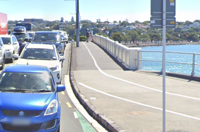
1 July 2022
Page 2 of 42
Reference: Waihoehoe Precinct
Each of these issues are addressed in detail within this letter. In addition, responses are also provided
to each item within the Commute Memo Appendix (provided as Attachment 1 to this letter).
1 Consent Implementation Issues at EPA Stage.
Item 3.2 and several further items refer to concerns relating to acquiring EPA for items where AT does
not agree with the applicants’ design approach. This issue is dealt with in detail within the memo to the
EPA dated 1 July 2022 prepared by the applicant’s counsel Mr Brabant (“Brabant Memo”). The
Brabant Memo explains why a consent should not be withheld due to unresolved matters of detail that
are better addressed at EPA stage.
2 Waihoehoe Road Bridge Interim Design
Item 3.4 of the Commute Letter agrees that the Interim design is “the best and safest way of using the
width available on the bridge (without widening / replacing / new walking and cycling bridge).”
Comments were previously provided on this matter (Stantec Response Letter dated 13 April 2022), but
for the sake of brevity were kept succinct. This section now seeks to expand upon earlier responses
and discuss the matter in further detail.
The over-arching response is that it is acknowledged that the design has shortfalls against TDM
guidance, but when considering options available it is the best option available.
2.1 Current conditions
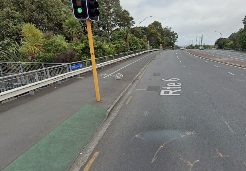
The overbridge for Waihoehoe Road over the rail line to the Great South Road roundabout is currently
one lane each direction, plus shoulders, and a narrow footpath on the northern side. The approximate
width between railings is assumed as 10.4m to be conservative for design purposes at the fast-track
application stage concept work.
This current layout provides acceptable conditions for motor vehicles (to an acceptable level for the fast-
track application traffic flows), but very low convenience and safety for people on bicycles and on foot.
2.2 Likely timing of permanent bridge replacement
In the short-medium term, this overbridge requires a substantial rebuild, regardless of the Drury East
Plan Changes or Fast Track applications. The main reasons for this are:
o To allow the triple / quadruple-tracking of the North Island Main Trunk (NIMT) rail line.
o To allow the additional traffic lanes as per the intended long term 30m wide Notice of Requirement
arterial road layout and nearby intersection layout at Great South Road (to cater for flows beyond
those of the current fast-track application area volumes)
o To provide significantly improved walk and cycle facilities of a standard as per the intended long
term 30m wide Notice of Requirement arterial road layout on Waihoehoe Road
The indicative design within the NOR shows six traffic lanes over the rail line plus separated cycleways
and footpaths on both sides of the road. It is acknowledged that the timing for the new rail overbridge is
not yet confirmed, albeit it is understood as possible that an announcement on this may be made soon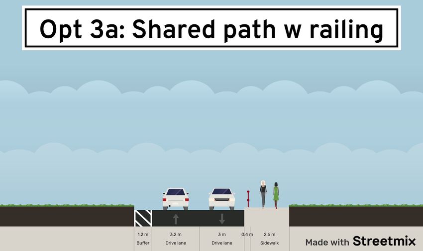
1 July 2022
Page 3 of 42

Reference:      Waihoehoe Precinct

by authorities – potentially aimed at constructing the new bridge as part of the nearby Drury Central
train station works by early 2025 1.

Related to this, it is considered relevant that Waka Kotahi has, in February 2022 2, begun early works on
replacing the three motorway rail overbridges over the NIMT, which includes moving the motorway
alignment to the east, and providing for a future quadruple tracking. While these works, due to their
extents, are expected to take until 2026/2027, they clearly show that quadruple tracking enabling works
are already occurring – only 800m away.

Also related to this is the fact that the electrification of the rail line to Pukekohe (also currently
underway) is planned to be complete by the second half of 2024 3. Until then, the commuter functions of
the NIMT to Pukekohe are undertaken by rail replacement buses. The lack of commuter trains, and the
fact that any new lines are not yet electrified, mean it would be much easier to construct the new bridge
in the short term. In summary, while no timeframes can yet be confirmed for the permanent overbridge
replacement, it is likely that any interim layout as part of the fast-track application may quickly be
superseded by the permanent layout.

2.3            Alternative Interim options considered

In reviewing potential interim options for improving walking and cycling safety on the existing
overbridge, the following alternative options were considered as part of the decision process to select
the proposed interim upgrade presented in the fast-track application:

        o    Option 1: Narrow cycle lanes (Option 1, Attachment 2)
                o By narrowing the current wide traffic lanes to only 3m each (feasible due to the straight
                    alignment), it would be possible to add narrow cycle lanes and narrow separators
                    (raised hard-rubber strips or similar) between the vehicle lanes and cycle lanes.
                o One cycle lane would be slightly wider (1.4m) than the other (1.2m), due to the fact that
                    one lane (the westbound lane) would be directly adjacent to a railing. The existing
                    ~1.2m wide footpath on the north side would be retained effectively as is.
                o While arguably safer for people on bikes than the current solution, it is considered that
                    this option retains some significant issues. In particular, it would require departures
                    from standards for narrow cycle lanes, narrow (and likely traversable) separators and
                    sub-standard footpath width. The single footpaths would remain narrow albeit
                    somewhat set back more from the cycle lanes.
                o The option also has narrow general lanes and would require a departure for these lane
                    widths.
                o Overall, this option is considered feasible and safer than existing, but would provide
                    limited improvement.

        o    Option 2: Narrow shared paths (Option 2, Attachment 2)

1   https://at.govt.nz/about-us/news-events/end-of-the-line-in-sight-for-auckland-s-diesel-commuter-trains/
2https://www.nzta.govt.nz/assets/projects/sh1-papakura-to-bombay/sh1-papakura-to-drury-project-
update-april-2022.pdf
3   https://at.govt.nz/about-us/news-events/end-of-the-line-in-sight-for-auckland-s-diesel-commuter-trains/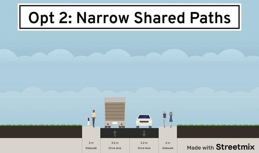
1 July 2022
Page 4 of 42

Reference:     Waihoehoe Precinct

                 o   In this option, as per Option 1, the traffic lanes are narrowed, but the achieved width is
                     instead allocated to provide two narrow shared paths on each side. This would provide
                     3.2m wide lanes (with 0.2m channel allowance) and 2.0m wide shared paths each side.
                 o   This option would provide walking and cycling facilities on both sides of the bridge,
                     reducing the need for people to cross the road to a single-sided facility.
                 o   However, pedestrians would have to share with people on bicycles for over at least
                     25m-30m distance, in a narrow path environment. At 2m width this is lower than the
                     2.5m absolute minimum of the Transport Design Manual, which also is to be used only
                     over a shorter distance of 15m length.
                 o   With traffic and substantial heavy vehicle flows directly adjacent to these narrow shared
                     paths, this option was not considered safe enough to proceed with.

     o       Option 3: Standard shared path (Option 3, Attachment 2)
                o In this option, as per Option 1 and 2, the traffic lanes are narrowed, but the achieved
                    width is instead mostly allocated to provide a single 3.0m width shared path on one
                    side (south side in the fast-track application plans).
                o This would provide an effective 3.2m wide lane in westbound direction (including the
                    channel on the shared path kerb side), a 3.0m wide lane on the non-shared path
                    eastbound side, and a 1.2m marked eastbound shoulder.
                o The key advantages of this solution would be that it would provide a wider shared path
                    solution, and also create less constrained general traffic lanes.
                o For these reasons, and because other options discussed below were not deemed
                    appropriate, Option 3 was taken forward to the application.

     o       Option 4: Separate walk/cycle bridge (not shown)
                o It was considered whether a separate, adjacent interim walk/cycle bridge would be
                    suitable to cater for the active mode facilities. This was quickly identified as having
                    significant costs and challenges.
                o If constructed to two-track width, it would still require a sizable span width of some 25m
                    or more. If constructed to future four-track width, this would increase costs further,
                    especially if KiwiRail opposed central supports.
                o Unlike the works on top of the existing bridge in Option 1-3, the new bridge would
                    require much more extensive works, above a live rail line. This is because freight trains
                    and commuter trains to Hamilton are still using the NIMT even while the commuter
                    connection to Pukekohe is suspended.
                o Depending on timeframes, from late 2024, the line to be spanned would also be
                    electrified. Even if the works occurred before the lines went live, the new bridge would
                    have to be built with modern added clearances and protections for the users against
                    proximity to electrical lines.
                o If constructed, a new bridge would represent a major work in the same timeline and in
                    close proximity to a major train station / interchange project nearby, increasing
                    complexity of approvals and works.
                o If constructed over the current two-track rail line width, it would need to be removed as
                    soon as the four-tracking project occurs.
                o If constructed close to the existing bridge, it would likely need to be removed as soon
                    as the new overbridge is constructed, as it would be expected to clash with the work
                    zones or new structures.
                o If constructed both to future four-tracking widths and further away from the existing
                    bridge, it would be out of line for the use by Waihoehoe Road active mode users - and
                    also require 3rd party land acquisition because it will extend beyond the existing road
                    corridor. This then presents the challenge of feasible physical implementation because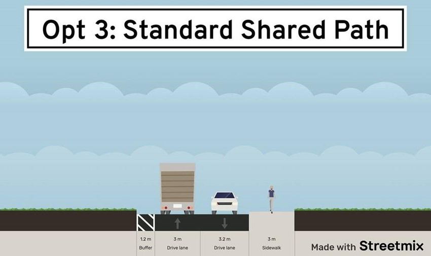
1 July 2022
Page 5 of 42

Reference:     Waihoehoe Precinct

                     it would require land that is not owned or controlled by any of the Drury East developers
                     (i.e. Kiwi Property, Fulton Hogan and Oyster Capital).
                 o   As noted above, the close proximity in space and time to various major infrastructure
                     works in the area (quadruple-tracking, new train station, new overbridge) may also
                     mean that in practice, the further (post-fast-track) approvals of such a new bridge would
                     be difficult and uncertain.
                 o   In Commute’s 27 June 2022 memorandum, the risk is raised that the application layout,
                     if not favoured by Auckland Transport, might be rejected at EPA, leading to an
                     unimplementable consent. Arguably, the same applies even more to a new bridge in
                     these constrained circumstances.
                 o   If despite all the above constraints, a feasible location can be found and approval from
                     the various parties, including KiwiRail, be achieved, the resulting structure will be
                     significantly more complex and costly compared to a “simple” walk/cycle bridge say,
                     bridging a stream.
                 o   Considering the lifetime of the new bridge might well be measured in a handful of
                     years, this option was discarded as unreasonable.

     o       Option 5: Clip on widening to bridge (not shown)
                o It was also considered whether it would be feasible to attach a “clip-on” structure to the
                    existing bridge to provide additional space for walk / cycle facilities, easing the
                    constraints experienced by the above options.
                o Any cantilevered structure, even if only supporting active modes, can place significant
                    strain on existing support structures of an aging bridge. This potential issue increases
                    with width and length of the facility.
                o It is therefore considered likely that any substantial-width clip-on, even if not effectively
                    needing to be designed as a new bridge, would still incur many of the costs and
                    downsides of Option 4, for less active mode benefit – and no greater certainty of being
                    in place for longer. As such, this option was also discarded.

2.4            Other factors / responses in support of the application interim
                      layout

Structural concerns regarding location of shared path:

Among other aspects, concerns have been raised in Commute’s 27 June 2022 memorandum regarding
the structural feasibility of removing the current northern-side footpath, replacing it with a trafficable
shoulder and adding the interim shared path on the south side. These concerns are acknowledged, as
the required structural assessment has not yet taken place.

     o       However, it is noted that if, on further structural assessment, this concern is realised, the interim
             layout proposed can feasibly be mirrored, with the shared path located on the north side.
     o       While this change (if later found to be required) would place the shared path on the bridge on
             the opposite side from the shared path for the rest of the fast-track interim design for
             Waihoehoe Road to the east, there is sufficient space in the immediate bridge vicinity to the
             west and east to place the shared path on the north side.
     o       This crossing location to the onward shared path eastwards on Waihoehoe Road could be at a
             mid-block location, or, possibly more suitably, cross to the south side at the new train station
             intersection at Kath Henry Lane.

As such, this concern if it eventuates, would not make the overall concept unfeasible.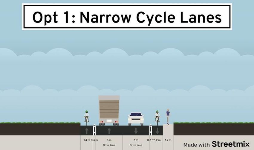
1 July 2022
Page 6 of 42

Reference:     Waihoehoe Precinct

Concern over proximity of shared path users to live lane

Concerns have been raised in Commute’s 27 June 2022 memorandum, and by AT, about the proximity
of the proposed 3.0m wide interim shared path to a live lane.

It is considered that while not ideal, this is actually a very common situation across Auckland – and thus
acceptable for a temporary interim solution. It is also noted that where providing retrofit facilities, or
changes to existing roads and intersections, Auckland Transport and Waka Kotahi also continue to
occasionally approve and construct shared paths immediately adjacent to live lanes – citing constraints
in space and funding, even where no clear path to later upgrade is available.

The most prominent Auckland examples of existing shared paths adjacent to live lanes are both on the
Tamaki Drive shared path, at Ngapipi Bridge (near Ngapipi Road intersection) and opposite The Strand.
This existing shared path on the Ngapipi Bridge is of similar width as the fast-track interim proposal
(approximately 3.0m) – but the section located directly adjacent (no buffer zone, railing or crash barrier)
is much longer, at approximately 90m instead of 30m. Likewise, on the northern side of Tamaki Drive
opposite The Strand, a 60m long section of the shared path that connects two stretches of separated
cycleways / footpaths narrows to 3m and is adjacent to the live lanes.

Figure 1: Street View of Tamaki Drive Shared Path over Ngapipi Bridge
1 July 2022
Page 7 of 42

Reference:     Waihoehoe Precinct

Figure 2: Tamaki Drive shared path adjacent to the Strand

Tamaki Drive is Auckland’s busiest cycle route, with, regular daily numbers of more than 1,000 users,
and on some days, more than 2,000 riders.

The adjacent traffic lanes of the arterial road carry approximately 18,000 vehicles per day (at Ngapipi
Bridge). As such, the situation is highly comparable – except that the active mode user demand on
Waihoehoe Road will be significantly lower, reducing the likelihood of conflict on the path.

Despite this existing situation being in place on Tamaki Drive for nearly 50 years (the facility has been a
legal shared facility since 1976), the applicant is not aware of any safety issues related to this bridge
shared path adjacent to the traffic lanes.

It is acknowledged that Auckland Transport has a project in the works to add an active mode bridge
adjacent to the existing Tamaki Drive Ngapipi Drive facility, which will in the coming years reduce or
remove the downsides of the shared path, however, the design also does not have a buffer to live traffic
lanes.

Therefore, providing a similar facility on a much less busy active mode route, when there is an imminent
future upgrade, is considered appropriate.

Low demand levels, further reduced

One of the key concerns regarding a shared path is the potential for conflicts of users, and thus the risk
of this leading to a user accidentally entering the adjacent traffic lane. This clearly is highly dependent
on the level of use of the path.

It is considered that the section of path on the rail bridge will not see very high use, as current origins
and destinations are still limited.

Crucially in this regard, the main future pedestrian origin/destination in the area, the coming Drury
Central train station, will have its own rail overbridge, and an entrance off Great South Road. This
allows access from both sides of the rail line (and depending on possession of a HOP card / gating
arrangement, may even allow “through trips” through the station for people not catching a train or bus).
1 July 2022
Page 8 of 42

Reference:     Waihoehoe Precinct

In a local context, this will mean that many pedestrian users of the station who would otherwise use the
new shared path on the rail overbridge will find the station’s own overbridge much more convenient,
reducing interim usage on Waihoehoe Road, and thus any conflicts.

Potential railing addition (as per Option 3a, Attachment 2)

As discussed in the above and in the application, the proposed 3.0m shared path complies with
Auckland Transport’s minimum width – the issues raised appear to be largely with the lack of separation
from the traffic lanes (normally, a shared path is to be located 1m or more away from the live lane
according to Auckland Transport’s guidance).

While in the constrained situation found on the existing bridge, adding this separation is not feasible, a
potential change to the application design would be to provide a heavy-duty pedestrian fence between
the shared path and the live lanes. This would require approximately 0.4m width (nominal railing width
allowance of 0.1m width, and 0.3m setback from the kerb).

While this railing design would constrain the remaining path to 2.6m width, such a railing would result in
a facility that would significantly reduce the remnant risk of any active mode user accidentally entering
the live traffic lanes. With the comments above regarding likely low patronage, and the interim nature of
the facility, it is considered that this adjustment would provide a way forward to overcome the key
concern raised.

2.5            Rail Bridge Interim Design Conclusion
Given the above discussion, the following conclusions are evident:

     •       The proposed interim design will represent a shortfall against TDM, but will provide a safe and
             convenient solution in the interim until the full bridge upgrade is provide as per the NOR design;
     •       There are examples of other interim designs in Auckland that have similar TDM departures, but
             have significantly higher active mode and traffic demand;
     •       The alternatives considered are considered either inadequate or too complex from a
             constructability / disruption perspective.

As such, the proposed interim design is considered the most pragmatic and effective approach.

3              Waihoehoe Road Bridge Construction Methodology
Item 3.4 of The Commute Letter discusses the construction of the Ultimate upgrade to Waihoehoe Road
Rail Bridge in the future that is enabled by the NOR, including the following excerpt:

                    “This upgrade requires substantial regrading of Waihoehoe Road, on both sides of the
                    bridge. The plans within the NoR shows the height difference between the existing and
                    final carriageway level, being up to 4.23 metres. This is likely to result in significant
                    challenges in keeping Waihoehoe Road open to traffic (especially in two directions)
                    during construction. As a result, it is likely that when this upgrade occurs in the future,
                    access to the subject site will be restricted to Fitzgerald Road.”

It is acknowledged that upgrading an existing road corridor and bridge whilst retaining current use is an
aspect that requires consideration. However, this issue is best dealt with at EPA stage (of the Ultimate
upgrade works) when construction methodologies are known.
1 July 2022 Page 9 of 42 Reference: Waihoehoe Precinct There are many excellent examples of construction methodologies that have overcome such constraints on much busier transport corridors. One recent example is the Eastern Busway between Panmure and Pakuranga. As with Waihoehoe Road, the Pakuranga Road corridor and its new bridge were both constructed alongside the existing corridor and bridge, then a series of contra-flow traffic management systems minimised traffic disruption as the old and new sections were completed. As in this case, the new Panmure Bridge is also several metres higher than the old bridge (which has remained). A similar methodology is feasible for this project, especially as the NOR widens the corridor at only one side of the road, which enables such lane flexibility used at the Eastern Busway. 4 Construction Traffic Management Plan Item 3.5 of the Commute Letter requests truck routes, which were not provided within the Outline CTMP provided with the ITA. The truck route for this site will be Waihoehoe Road (west), Great South Road, State Highway 1. Given the response in Section 3 of this letter, it is anticipated that careful construction methodology of the future Waihoehoe Rail Bridge construction can adequately ensure that this route will always be available. For minor road closures that may be required, these are anticipated to be overnight only. However, in the unlikely event that a brief daytime closure of Waihoehoe Road rail bridge is required, then trucks will use the Fitzgerald Road to Quarry Road, then travel to SH1 via Maketu Road (via the Ramarama Interchange) or Great South Road, SH22 (via the Drury Interchange). As these routes are already used for construction and earthworks traffic as part of the Drury South development, no issues with regard to safety or capacity are expected. The Commute Letter also recommends a change to the CTMP condition to ensure integration with other construction projects within Drury. This change is acceptable and has been included in the revised conditions. 5 Cul-de-sac / Shared Path Designs Items 5.4 – 5.6 of the Commute Letter discuss the proposed cul-de-sacs and the shared path connects at each head. Overall, Commute agrees that cul-de-sacs are an appropriate layout if they have appropriate active mode connections. However, Commute concurs with AT that a CPTED assessment is required to justify the departure from standard required to reduce the overall corridor width from 8m to 5m. This CPTED Assessment has been undertaken and is provided under separate cover by Barker & Associates. 6 Roading Layout at Site Boundaries Items 5.7 and 5.8 of the Commute Letter suggests that any roads that stop adjacent to neighbouring land should be provided / formed right up to the boundary. This request is acceptable, and a condition of consent is proposed to this effect.
1 July 2022
Page 10 of 42

Reference:      Waihoehoe Precinct

7            Vehicle Tracking at Key Locations
Item P3 of Attachment 1 of the Commute Letter requests additional vehicle tracking to demonstrate
compliance, particularly around 90deg curves.

Additional tracking for the 90-degree curves has been provided (all four parts of Sheet 1, and the top
two parts of Sheet 2 of Attachment 3).

It is acknowledged that the tracking shown for these 90-degree curves do not meet the “mid-block”
requirements of passing between a van and a rubbish truck. This is because functionally, they perform,
and have similar sizing to a small, compact residential intersection (where rubbish trucks are not
assumed to have to be able to turn at the same time as another vehicle coming out of the 90-degree
adjoining road). Such tight local road curves are common throughout Auckland, and these in fact assist
with traffic calming / slow speed environments (tight curves are explicitly noted as traffic calming
features in the relevant sections of the TDM). As long as sightlines are appropriate for such a slower-
speed low-volume environment (which they are), drivers will naturally negotiate giving way to (or be
given way by) a rubbish truck passing the other way.

Designing these as full curves would follow a more “mid-block” logic that would require road widening
and encourage speeds not considered appropriate for these locations.

It is also acknowledged that several of the vehicle tracks shown overlap with kerblines etc. This merely
reflects the level of detail that is necessary at resource consent stage, as opposed to EPA stage. For
EPA, any remaining minor changes to accommodate the tracking will be undertaken alongside
incorporation of other comments received as part of the AT consultation at that time. Modifying the
designs at resource consent stage to accommodate the tracking only to make further changes at EPA
stage is inefficient.

8            Waihoehoe Road / Road 16 Intersection
Item P20 of Attachment 1 of the Commute Letter requests further information regarding the design of
the Waihoehoe Road / Road 16 intersection.

Additional information / refinement of this signalised layout, and associated vehicle tracking, is now
provided in Attachment 4 of this letter. The plans also show visibility checks to the two zebra crossings.

For the eastbound approach on Waihoehoe Road to the western zebra crossing, we have reviewed this
initially for 70 kph (the current speed limit of Waihoehoe Road) and also for 50kph, which we consider
more appropriate for this location, even with the current condition. The latter is because a driver
approaching this intersection and turning left is going to be highly conscious that this is an intersection
(not a left-turn free-flow curve). Factors in this regard are the presence of an upcoming median island
including a slight left deflection of the through lane, the presence of traffic signal poles, the raised-table
zebra visible ahead left, and the relatively tight curve (sized for 10.3m rubbish trucks, i.e. for local road
conditions). In practice, this slip lane will function very similar to any raised zebra crossing slip lane in a
signal. With the added physical reinforcement of the raised table, practical crossing speeds will be more
likely to be around 30 kph. However, crucially, even the 70 kph sightline requirement can be met,
assuming no obstructions are located in the sightline where it passes outside the current road corridor.
The applicant is willing to agree to a consent condition keeping this sightline clear - and it is important to
note that this sightline passes through area that the NOR intends for road widening, i.e. will not be
developed in any case.
1 July 2022
Page 11 of 42

Reference:      Waihoehoe Precinct

For the approach from the north on Road 16, we have assumed a 30kph speed environment (and
formal speed limit), as this will be a very narrow local road, with traffic calming as required on all local
roads. The required sightlines are met.

Reaction time chosen was 2.0s instead of 2.5s even for the Waihoehoe Road approach, which in the
near-term future could still be considered rural. This is because the conflict only occurs if the driver
voluntarily steers left into the side road, i.e. it can be considered that the driver is at normal alert state,
rather than less alert as might occur on a straight-through rural road approach to a mid-block crossing.

The plans now also show key dimensions, some minor road marking additions (limit lines, give way
triangles etc), and the proposed traffic signal pole locations. For clarification, as the path on the south
side of Waihoehoe Road is a shared path, and as Road 16 is a local road, the crossing has been shown
as a wide pedestrian crossing, but this could alternatively be a split walk/cycle crossing.

9              Active Mode Facilities between Drury East and Drury
                     South
Item P58 of Attachment 1 of the Commute Letter raises a minor concern regarding upgrades between
Drury East developments and Drury South.

It is acknowledged that the project does not provide additional active mode upgrades south of any other
Drury East Fast Track development connections. This is considered to not be necessary for several
reasons:
      • The proposed development, and the overall upgrades outlined in Plan Changes 48, 49 and 50
         focus almost all journeys towards the now consented Drury Central train station, the
         metropolitan centre to continue north linking to the train station, the other Drury East Plan
         Change 4 areas and associated Fast Track development proposals, and the external street
         network via Waihoehoe Road. The traffic modelling established that the vast majority of the
         demand will be to those destinations, and only a relatively small number of trips (by all modes)
         will be made to the south;
      • There is an existing shared pathway provided along Waihoehoe Road and Drury Hills Road that
         provides an active mode connection between Drury East and Drury South. Although it may
         necessitate journey diversions, it does represent an unbroken active mode connection should
         some users prefer to use that route;
      • It is considered that connecting this project, and the wider Drury East Plan Changes (48, 49 and
         50) to the closest development area in Drury South is unnecessary and beyond the scope of
         mitigation required for this project;
      • It is anticipated that as part of Plan Change 49, further active mode upgrades on Fitzgerald
         Road to the south of Brookfield Road will be provided as part of subsequent resource consent
         stages. That Plan Change’s precinct provisions ensure that any development fronting any of
         the collector roads needs to provide active mode upgrades towards the train station and
         Waihoehoe Road. So as ongoing resource consent or Fast Track applications are submitted
         that front Fitzgerald Road, the upgrades will move further south;

4   Private Plan Changes 48 and 49.
1 July 2022
Page 12 of 42
Reference: Waihoehoe Precinct
• It is anticipated that as Drury East continues to urbanise as anticipated and planned for within
the Council’s Drury-Opaheke Structure Plan with future subsequent plan change applications to
rezone the remaining Future Urban zoned land between Drury East and Drury South that will
appropriately address active mode connections between the two destinations; and
• By way of background and during caucusing for the Drury East Plan Changes, Council’s
consultant traffic engineer (in their capacity as regulator) also queried if active mode
connections to the south should be provided. This was addressed within the plan change
hearing evidence for the Drury East plan change applicants that upgrades south of the plan
change areas were outside of the plan changes mitigation remit. The Hearing Panel agree, and
the Panel’s decision found in favour of the applicants– i.e the requested addition by Council to
include upgrades to the south within the transport upgrade standard were rejected.
As such, it is considered that the request for additional active mode connections on Fitzgerald Road to
the south of the Drury East Fast Track Applications are unjustified and unwarranted for the mitigation of
any adverse effects arising from this project.
Yours sincerely,
STANTEC NEW ZEALAND
Daryl Hughes
Daryl.hughes@stantec.com
Attachments:
Attachment 1 – Responses to Items within the attachment to the Commute Letter
Attachment 2 – Rail Bridge Options
Attachment 3 – Vehicle Tracking Drawings
Attachment 4 – Waihoehoe Road / Road 16 Design8 June 2022
Page 13 of 42
Reference: Drury Centre Precinct
ATTACHMENTSATTACHMENT 1 Comments on Issues Raised in the Attachment to the Commute Letter
A
                                                                                                       DESIGN ISSUES : WAIHOEHOE
                                                                                              (Itemised as per Stantec response 13 April 2022

    Item   Auckland Transport Issue (summary)                         Applicant’s position (summary)                             Commute Comment                                        Stantec Response

    P51    It has already been assessed that the proposed             The extent of external mitigation is considered to be      Agree with applicant that the modelling does in        Resolved.
           development will require additional transportation         beyond that required to reasonably mitigate the            general show that the mitigation proposed to be
           infrastructure than that proposed to be provided by        transport effects of the developments.                     appropriate.
           the Applicant as part of this consent application. In
                                                                      The extensive traffic modelling undertaken
           particular, Auckland Transport’s consultant, Mr
                                                                      definitively established that the mitigation provided
           Prosser concludes at paragraph 5.3 of his report that
                                                                      within the Fast Track application is sufficient to
           “[b]ased on the level of mitigation proposed by the
                                                                      mitigate the effect of the development on the wider
           Applicant, I have assessed the Application’s adverse
                                                                      transportation network. Auckland Transport has not
           traffic effects as being more than minor and
                                                                      provided any analysis to demonstrate that this will not
           potentially significant” (refer Attachment 2).
                                                                      be the case
    P53    Many of the following comments and those found in          Comment addressed in the following sections.               See following sections                                 See following sections.
           Attachments 2, 4 and 5 refer to aspects of the
           Applicant’s proposal that are either unclear, do not
           appear to meet TDM standards, and which may
           require further information or consideration for a full
           assessment of effects to be undertaken
    P55    The proposed road layout relies on one main access         The overall layout, including cul-de-sacs is designed to   We do agree with Auckland Transport in that poorly     Discussed in Section 5 of this letter. In summary, a
           road into the western and eastern parts of the site,       remove access to Opaheke Road, which will                  designed cul-de-sacs can lead to poor connectivity.    CPTED assessment has been provided under
           with a predominance of cul-de-sacs. It is recognised       eventually be upgraded to a four lane FTN arterial,        We do however agree with the applicant in that every   separate cover.
           that providing additional through road connections to      and has protected active mode connections along its        cul-de-sac has an active mode connection and thus
           Ōpāheke North-South Road (being a future                   length. Every cul-de-sac has an active mode                the layout is considered appropriate (subject to
           FTN/arterial road) is not desirable, however cul-de-       connection at the end removes any barrier to safe          design review in P57).
           sacs are not generally favoured as they can lead to        and convenient active mode access throughout the
           poor connectivity for active modes where                   precinct
           pedestrians/cyclists need to travel around a longer
           more circuitous route to get to local destinations. This
           can be overcome by providing active mode road to
           road links (i.e. shared paths/accessways) but they
           need to be designed correctly.
    P56    There are four road to road shared paths proposed to       Noted                                                      Noted                                                  Noted.
           be vested to Auckland Transport according to the
           scheme plans (Lots 524, 523, 522, 521), to
           provide access from the
           American Style cul-de- sac heads (Roads 11, 12, 13,
           14) to the arterial road, Ōpāheke North-South Road.
           The ITA describes the shared paths as being 5m
           total width, with 1m landscaping on each side and a
           3m wide shared path, varying between 15-25m in
           length
    P57    It is recommended that shared paths should be              The shared paths with a real transport function are        We agree with Auckland Transport unless the            Refer to item P55.
           designed to be 4m in width with defined spaces for         the ones located between the eastern cul-de-sac and        CPTED assessment is undertaken to confirm the
           pedestrians and cyclists to avoid conflict and it is       Opaheke Road. These are very short (15-27m, or the         proposed width (less than TDM) is provided and
           recommended that the total accessway                       length of one allotment) and not “through routes”,         shows the design to be appropriate. As this has not
                                                                      more so they are a short connection                        been provided, we consider the full 8m should be
                                                                                                                                 provided.
1 July 2022
Page 17 of 42
Reference: Waihoehoe Precinct
width should be 8m for accessways between roads (as to access the fully on-road facilties. Treating these as
per the design requirements of the TDM). separated paths implies that the user would actually
separate themselves to the appropriate side, which
given the short length, is unlikely given the short
desire line. In this context, providing a separated path
would simply overcomplicate things, particularly at
the ends, where the separated cycleway would then
need a give-way (potentially raised) crossing over the
footpath.
The safety impacts of shared paths relate to two key
issues - sightlines and the path level of use. By virtue
of (relatively wide) corridors and open, right-angle
intersections, the first is avoided, and the second is
not going to be an issue because these are not
through routes, they are the lowest level of dispersed
use by bike riders, rather than a "collector" cycle
element or similar.
A CPTED assessment will be provided at a later
stage of development
P58 It is considered that there is the potential that active The proposed development will provide superior We partly agree with Auckland Transport. We This is discussed in Section 9 of this letter. In
modes are not well provided for, with insufficient active mode connections to and from all roads which consider the active mode / PT link to the future Train summary, active mode connections to the south are
shared path design and the potential for more than will not result in a car dependent suburb. In particular, station to be appropriate however have a minor not considered necessary as part of this
minor adverse safety effects on users. Given the cul- active mode facilities (both pedestrian and cycle) are concern that to the south (Drury South) there is development.
de-sac layout of the development this poses a risk provided on Waihoehoe Road, Opaheke NS FTN minimal provision. It is however noted that there is an
that residents will instead rely on the use of private Arterial Road and via a number of walkways from the existing shared pathway provided along Waihoehoe
motor vehicles. It is noted that Policy B2.3.2 of the cul-de-sacs to the Opaheke NS Road. Road and Drury Hills Road (although noting it may
RPS requires that the form and design of subdivision necessitate slight journey diversions). We consider a
develops street networks and road patterns that safe and efficient pedestrian / cycling facility can
provide good access and achieves a high level of therefore be provided from the site to Drury South.
amenity and safety for pedestrians and cyclists. It is
not considered that the proposal accords with this
policy in its current form.”.
P60 The proposed roading layout provides some potential The applicant has not proposed to construct these We agree with Auckland Transport. These roads This is discussed in Section 6 of this letter, this has
for future east-west road connections should the sections of road in order to avoid constructing roads should be fully provided to the site boundary of been accepted and revised plans provided under
adjacent properties be developed, however it is noted against a 3rd party boundary to maintain amenity and adjacent sites. separate cover.
that the Applicant does not appear to be proposing to avoid disruptions related to road construction where it
construct these connections as built roads (Lots 511, is not required. These sections of road are not
502, 509, 1018, 1016), instead only vesting the land. required to service the proposed development and the
This is not supported by Auckland Transport and it is proposed vesting of roads is sufficient to safeguard
considered that it should be the Applicant’s these east-west connections.
responsibility to construct these road sections at the
time of development. Auckland Transport does not
accept the vesting of ‘paper roads’. These
connections are deemed important to ensure that
future east-west connections are enabled by the
current consent application. This is particularly
important in the absence of an approved Precinct
Plan under the plan change process that would
better define the roading layout for future developers1 July 2022
Page 18 of 42
Reference: Waihoehoe Precinct
P61 Should the east-west connections not be enabled for See response to Item 60 above See response to Item 60 above See response to Item 60 above
future development of the adjacent land, it could
result in a series of cul-de-sac reliant residential
developments, with the only ingress and egress
being directly onto Waihoehoe Road. This is a likely
scenario given the shape of the remaining lots
adjacent to the subject site (i.e. being rectangular
with a narrow frontage to Waihoehoe Road). This
has the potential to create more than minor (and
potentially significant) future
operational and safety effects on Waihoehoe Road. It
is noted that Lisa Mein has prepared an Urban Design
assessment for Auckland Council, where she has
made additional comments in relation to connectivity
and the road layout. Ms Mein’s assessment is
supported by Auckland Transport (refer to Auckland
Council’s response
P62 The Applicant is requested to build the road See response to Item 60 above See response to Item 60 above See response to Item 60 above
connections to the boundary and provide temporary
turning heads in accordance with the TDM. This
should form conditions of consent, should the Panel
be minded to grant consent
P68 As previously discussed, the Council is not in a The applicant, along with its Drury East Fast Track In general, we agree that the proposed mitigation is The matter of appropriate mitigation is resolved.
position to finance and fund the above upgrade partners, is providing a comprehensive suite of appropriate to mitigate the effects of the
identified as being necessary by Mr Prosser. The infrastructure upgrades that will enable the development. The matter of seeking EPA approval for aspects not
upgrade of Waihoehoe Road west to Drury Central development to operate in a safe and efficient agreed at consent stage is discussed in Section 1 of
Station is particularly relevant to this consent manner. The street network is designed with active this letter. In summary, the Brabant Memo of 1 July
application to enable the future residents of the modes as the primary focus. As outlined in the AT’ have reiterated their preference for a separated outlines why a consent should not be withheld due to
proposed dwellings to safely access Drury Central application, every household will be linked to the Drury walking and cycling facilities on both sides of unresolved matters of detail that are better addressed
Rail station via active modes. It is recommended that Central Rail Station, the other fast track areas and the Waiheohoe Road (essentially more in accordance at EPA stage.
the Panel consider the requirement for the Applicant external network via active mode links built to best with the final layout), although the ITA advises that
to undertake the full arterial upgrade as practice guidelines i.e. with protection from cars and “…separated cycle lanes and footpaths on both sides
recommended by Mr Prosser. Should the full arterial separation between pedestrians and cyclists. of the road are not able to be provided in the
upgrade not be supported by the Panel, it is proposed interim cross-section”. However, without
The sole exception to best practice - the shared path
recommended that additional upgrades be AT’s approval of the cycling facility, we are
facilities on Waihoehoe Road west of Fitzgerald Rd -
considered to at least a collector road standard, as concerned that EPA approvals may not be
were a compromise agreed during the Plan Change
further detailed the attached Traffic Engineering forthcoming.
traffic caucusing between all parties except Mr
Assessment (Attachment 4).”
Prosser for Auckland Transport, to enable the
addition of a westbound bus lane towards the train
station within the constrained interim 20m corridor. On
all other collector and arterial road sections, walking
and cycling facilities are provided on both sides.
While these facilities may change slightly along the
routes in terms of cross-section width and location (for
example where the topography is constrained), they
form a coherent and connected network of walk and
cycle facilities to high standards
As outlined in the AEE, the required transport
upgrades to support the proposed developments will
be delivered by the developer, or jointly by the
developers, such that there is no obligation or1 July 2022
Page 19 of 42
Reference: Waihoehoe Precinct
reliance on the Council to fund or deliver the required
transport upgrades
P70 Specific comment is made in relation to the The interim design proposed is considered adequate We acknowledge and agree that the arrangement This is discussed in further detail in Section 2 of this
Waihoehoe Road interim upgrade west of Fitzgerald from a road safety perspective, albeit it is proposed on the bridge is the best and safest way of letter. In summary, the proposed layout is the best
Road proposed to be undertaken as a joint upgrade acknowledged as more limited than other active using the width available on the bridge (without option available due to several constraints but
by all three developers, specifically where it meets mode facilities elsewhere within the application. The widening / replacing / new walking and cycling provides adequate interim active mode connection.
the Rail Overbridge as it is considered to present a 3m interim shared path is a better short-term bridge). We do consider some further improvements
key safety concern. The Applicant’s ITA states that walk/cycle facility solution than many permanent and to available width may be possible with the The matter of seeking EPA approval for aspects not
traffic modelling has identified that added lanes are recently constructed cycleway locations within replacement of the outside handrail (eg attaching the agreed at consent stage is discussed in Section 1 of
not required, and the only upgrade proposed is a 3m Auckland. Where away from the short GSR handrail to the outside rather than top of the bridge). this letter. In summary, the Brabant Memo of 1 July
wide shared pedestrian and cycle path on the intersection / bridge section itself, the path is outlines why a consent should not be withheld due to
southern side of the bridge, requiring narrowing the separated well from the carriageway. unresolved matters of detail that are better addressed
traffic lanes to 3.0m and a 1.2m shoulder on the We do however have the concern that AT do not at EPA stage.
The constrained facility is considered acceptable as it
northern side. The ITA further states that: agree with the proposal which may create significant
covers only a relatively short length (less than 50m),
issues at later stages. If AT do not accept the
“In the long-term, it is expected that the overbridge and as it does not represent a major local desire line
design through Departure from Standards process
will be rebuilt to allow the triple / quadruple tracking of (none of the fast track areas need it to connect to
this could lead to a very difficult situation during
the rail line and to allow the long-term layout of the each other, to the new Drury Town Centre, or to
the EPA stage and result in a consent that is
Great South Road/ Waihoehoe Road intersection (all connect to the train station / bus interchange). The
effectively unimplementable.
not part of this application). At that time, bus priority lack of expected high demand in the short term will
lanes and some queue storage lanes mean that volumes of pedestrians and cyclists on the
are expected to be provided on the overbridge, as bridge will remain low, reducing any interaction issues,
well as footpaths and protected cycle lanes on both and allowing more space away from motor vehicles for
sides. As this layout is highly dependent on future users. This lack of primacy of this link for active
adjacent intersection design related to Great South modes is also shown by the fact that new train station
Road, the final designs of the rail line bridges, and the / bus interchange east of the bridge was approved
layout of the nearby transport interchange planned by without any mandated upgrades to the existing
SGA, no likely long-term cross-section is provided.” bridge's walking facilities - which are currently
extremely poor. In comparison, the fast track
Comments are made in Auckland Transport’s application will provide a significant safety and
traffic engineering review as follows (refer Attachment amenity upgrade the bridge by providing a shared
4): path as discussed
“… the shared path and the traffic lane widths do not
meet AT standard for shared path or an arterial road
respectively. The 1.2m buffer on the right side is not
enough for an informal cycle lane. The handrail on the
shared path side is too low for cyclists. It is not a
good solution even in the short term
P71 It is considered that the design in this location will not Please refer to the response for Item 70, above Please refer to the response for Item 70, above Please refer to the response for Item 70, above
provide adequate or safe cycle and pedestrian access
to Drury Central Station and it is therefore
recommended that the interim upgrade in this section
of Waihoehoe Road be revisited by the Applicant in
terms of solutions that will address the potential
safety effects noted above1 July 2022
Page 20 of 42
Reference: Waihoehoe Precinct
P72 Auckland Transport is concerned that the existing It is accepted that the receiving roading environment We generally agree with the applicant however this is Truck routes are discussed in Section 4 of this letter.
quality of the rural road network in the vicinity of the of this greenfield area is rural with a historic lack of very difficult to assess as the draft CTMP does not In summary, the expected primary truck route and
proposed development will be insufficient to investment from the Road Controlling Authority. currently have the expected truck routes provided (so alternative routes used in the unlikely event that the
accommodate the anticipated construction traffic When the developments are being constructed, the we cannot say exactly where the trucks will go). It is primary route is briefly closed are considered
required for the proposed development.” applicant will undertake pavement assessments and recommended that the applicant comment further adequate from a safety and capacity perspective.
upgrade pavements where required. This will be on this issue.
discussed within the EPA package, and a condition
can be agreed accordingly
P73 Mr Prosser has made the following comments in this a) This statement is considered highly selective. We do generally agree with the applicant however Please refer to the response for P72 above.
regard, which are considered to be relevant to this There are no sections of public roads in the local this is very difficult to assess as the draft CTMP does
consent application (paragraph 2.1) (refer network (expected to be used by applicant not currently have the expected truck routes provided
Attachment 2): contractors) that are 5m wide sealed. Generally, the (so we cannot say exactly where the trucks will go). It
sealed widths range between 6.5m and 7m. Damage is recommended that the applicant comment
“I have significant concerns as to the quality of the
to local roads during construction can be managed via further on this issue.
existing rural network to accommodate construction
traffic from an operational and pavement/surface Construction Traffic Management Plans (CTMPs)
maintenance perspective for the following reasons: setting out truck routes - including focussing truck
access onto those routes that will be upgraded
(a) The Applicant’s Integrated Transportation permanently as part of the project, as well as specifying
Assessment (ITA) suggests the existing local rural appropriate monitoring regimes and, if needed, interim
roads, supported by an approved Construction Traffic remedial works before the final road layout is
Management Plan (CTMP), will suffice until such time constructed as part of or at the end of the construction
as the roads are rebuilt to an urban form. Based on my phases.
site visits and assessment of the local road network
conditions, I do not consider haulage truck and trailers
b) It is the Road Controlling Authority’s responsibility to
ensure that rural and urban roads are at an adequate
will be able to pass each other on the majority of the
pavement standard, therefore the poor condition of the
local rural roads (as has been suggested in the ITA)
subject roads surfaces are a result of a failure to
without causing edge break and disturbing the existing
undertake maintenance obligations. It should be noted
grassed berms.
that this is not a Drury specific issue that should be
(b) AT’s pavement asset records have confirmed that
addressed in this application. In any greenfield
all the roads in Drury East are older than 37 years in
development, anywhere in the country, the process of
pavement life. It is my experience that rural road
urbanising and improving pavements is necessarily
pavements typically require full restorationand
required. Notwithstanding that fact, the detailed design
replacement after 20-25 years. This is also under
and subsequent EPA lodgement for the road upgrades
normal rural traffic loading conditions and when heavy
will include a pavement assessment and, where
commercial vehicle demands are at around 3-5% of
necessary, remedial improvements. A condition can
their average daily flows. However, and as is the case
be prepared in that regard.
here, some roads last much longer where they are
not subjected to significant increases in heavy commercial
vehicles in particular.1 July 2022
Page 21 of 42
Reference: Waihoehoe Precinct
Furthermore, and as observed in the attached
c) Please refer to the earlier discussion of how the
application proposes to undertake exactly such
photographs (Annexure A), the existing pavement
roading upgrades.
and sealed surfaces are already showing signs of
failure and areas already having significant repairs. I d) Considering that the proposed framework is just
have concluded, without full restorative work, the that - a framework for discussion - this is not in itself
existing rural roads are not of an appropriate physical problematic. Appropriate arrangements and
standard nor are they able to support sustained monitoring / remedial regimes can be discussed at
volumes of heavy haulage vehicles transporting, EPA stage).
materials, machinery, and other equipment to and
from this development site over the planned
implementation period. It is therefore not a question
of replacing like for like as the standard of pavement
needs to be to an urban standard capable of
withstanding this traffic and the subsequent increases
in traffic associated with completed development.
This should not be a cost born by AT. Accordingly, I
recommend that all of the roads intended to be used
for access/egress and continued haulage for the
Waihoehoe Precinct’s establishment are upgraded
from the onset of its construction and to the correct
design standard
(c) This work will also require the full installation of an
urban roading form with AT Transport Design Manual
(TDM) carriageway features including dedicated
walking and cycling on the Collector and Arterial
Roads. Non-compliance with AT’s TDM and provision
of appropriate urban linkages to the development site
will cause a fragmented transport network and less
than desirable outcome. Accordingly, it is considered
necessary that any future development in Drury will
be, from the early stages of development, well
connected to the Drury Central Rail Station (now
consented) thus having effective and efficient public
transport facilities integrated with safe walking and
cycling infrastructure. Based on the details supplied
with this application, I remain concerned that there will
be gaps or substandard links in the infrastructure
which is required to enable and encourage active
modal travel to and from the Drury Central Rail
Station.
(d) While the Applicant has provided a suggested
CTMP framework, I do not consider it to be suitable for
the local rural network nor does it appropriately
address the provision of suitable cyclic road
carriageway maintenance and / or completion of
regular inspections and how/who will be responsible
for any repairs (and their approvals).””You can also read