Field-Expedient Celestial Navigation
←
→
Page content transcription
If your browser does not render page correctly, please read the page content below
Field-Expedient Celestial Navigation
                             Steven C. Carleton, MD, PhD
Celestial Navigation
Celestial navigation relies on the predictable relationship between celestial bodies and the
surface of the Earth. At any instant of time a celestial body is directly above a spot on the
Earth’s surface termed its Geographical Position, or GP. The GPs of the Sun, Moon, four
navigational planets (Venus, Mars, Jupiter, Saturn), and Aries (a reference point on the celestial
sphere) calculated for every hour of each year are published as The Nautical Almanac and
Astronomical Ephemeris. Tables allow for interpolation to minutes and seconds of time. GPs
are expressed in Greenwich Hour Angle (GHA), equivalent to celestial longitude, and
declination, equivalent to celestial latitude. The hour angles of 57 navigational stars relative to
the GP of the Sun at the vernal equinox (termed Aries), and their declinations, are included for
each day. The Nautical Almanac is bulky, but relevant pages for the dates of any planned
travel can be copied and carried.

Measurement of the angle between a celestial body and a natural (sea) or artificial horizon
places the navigator on a circle of equal altitude centered on the GP of the celestial body. A
sextant is used to measure this angle. Accuracy to within several minutes of arc (and thus
several nautical miles) can be accomplished under ideal circumstances. A small segment of
this circle forms a Line of Position (LOP), or Sumner Line, that is at a right angle to the bearing
line (azimuth) to the body. A single sight puts the navigator somewhere on this line. Two sights
yield lines that intersect at two points on the Earth’s surface. Three sights yield three LOPs
that intersect at a single point - a fix. This is the navigator’s position. A modification of this
method, the Altitude-Intercept Method of Marcq St. Hilaire, permits determination of a fix with
only two sights.

To reduce the sight to the navigator’s local area of travel, a navigational triangle is created and
solved. Sight reduction involves formidable math (spherical trigonometry) that can be
accomplished with a scientific calculator. Pre-calculated inspection tables also can be used.
These are bulky, but individual pages for the latitude of travel can be copied and carried.

While a latitude line from a noon sight of the Sun can be determined without reference to time,
the most powerful and flexible methods of celestial navigation require a clock accurate to
within a few seconds, and keyed to Universal Time Co-ordinated (UTC) [formerly Greenwich
Mean Time (GMT)].

Celestial navigation as described above was the standard for the determination of position and
direction from the 19th century to the 1950s. It has been supplanted by satellite navigation,
which is accurate to within several meters. Even optimally practiced, the accuracy of celestial
navigation is measured in miles. This is sufficient for ocean navigation since a landfall can
generally be identified from a distance of many miles, but is insufficient for land navigation
under most circumstances - one to five miles is an unacceptable margin of error when
searching for a trailhead, a camp or a supply cache. The equipment required for celestial
navigation can be reduced to a minimal kit weighing several pounds but is extremely unlikely to
be carried by an expedition, and even less-so by an individual trekker.

A functioning, mapping-GPS makes it virtually impossible to become lost - a functioning GPS.
The ready availability of GPS has the unintended result of allowing individuals to confidently
confront the wilderness without any grasp of more self-reliant methods of navigation. GPS
receivers are subject to the frailties of all electronic devices; they require batteries and these
batteries may perform poorly in exceptionally cold weather and when discharged, they may not
be particularly shock- or water-resistant, and they function poorly under heavy forest canopy, in
slot canyons and in other situations where access to the open sky is limited. Civilian GPS
service can be shut-down by the government in times of threat, and can be interfered with by
international adversaries and solar flares. As such, anyone traveling in the wilderness and
relying solely on their cell-phone or hand-held GPS receiver for route-finding is asking for
trouble.

Navigation by map and compass is the best self-reliant back-up to satellite navigation. But
successful map and compass navigation requires practice, pre-planning, and knowledge of
magnetic declination in the area of planned travel. Local magnetic variation can also seriously
impact compass accuracy. Unless factors that influence the magnetic compass are taken into
account, serious navigation errors can result: An error of 5 degrees in heading will result in a
systematic error of almost 500 feet per mile traveled. And obviously, map and compass
methods are only useful if one is actually carrying a compass and a relevant map.

How can you recover from being lost if you have only your wits and the contents of your
pockets? The environment is full of useful navigational cues. The reliability of some of these is
variable (moss on trees, the orientation of termite mounds), but celestial cues are absolutely
reliable for the determination of direction with an accuracy superior to that of the magnetic
compass. The fidelity of celestial methods for direction finding is evident in the historical use
of these techniques for the correction of both magnetic compasses and gyrocompasses on
military ships and aircraft prior to the advent of GPS.

Field-expedient celestial navigation will determine the cardinal directions with low-tech tools
that can be carried in a wallet or manufactured on the fly. It is not magic, however: If a traveller
becomes lost and has no familiarity with their general location, the appearance of the night sky,
the movement of the Sun with the seasons, or the limitations of a carried magnetic compass,
they are in deep trouble. Some pre-planning is required for no-instrument celestial navigation.
Thirty minutes on the internet should suffice to provide the information required. Online and
text resources are included in the Appendix. This information should not be trusted to memory
- it should be written on a slip of paper and kept somewhere where it will always be available.
Studying the night sky to allow easy recognition of useful stars and planets, and awareness of
the changing but predictable behavior of the Sun with the seasons are important. Photocopies
of one or two diagrams reduced to credit-card size, a pin or paper clip, some string, and this
knowledge will allow you to perform sophisticated feats of self-contained directional navigation
- and perhaps to recover when lost.

Angle Estimation

Portable methods of estimating angles are critical to field-expedient navigation. If carrying
string and a short or foldable cm ruler (even one photocopied on acetate), one can easily
construct an accurate device for measuring angular distances. When a ruler is held at a
distance of 57 cm from the plane of the face, each cm on the ruler will subtend about 1o of arc.
When held half this distance from the plane of the face, each cm subtends about 2o. Prior to
travel, drill or punch a small hole in the center of the ruler. Affix a string through this hole with a
knot, then tie overhand knots at 28.5 cm and 57 cm from the ruler. Now, if either knot is held
between the teeth or at the corner of the eye, the cm scale on the ruler can be used to
measure angular distances along the horizon. This is extremely useful for exploiting the use of
amplitude to establish the cardinal directions (amplitude methods will be discussed in a later
section). If a ruler and string are not carried, degrees of arc can be estimated with the angles
subtended by your fingers, thumb, fist and the span between various digits. There are many
sources which suggest that these measurements are consistent between different people - that
the length of the arm and size of the hand are in the same ratio from individual to individual.
This is crazy talk. Do not use these published angles. Rather, know thyself - measure in cm
the width of a few fingers, your thumb, your fist, the distance between your spread digits and
the distance between your outstretched hand and your eye. Apply a little trigonometry (side
opposite/side adjacent = tan θ) to determine what angles your hand and fingers measure, and
write it down or memorize the results. Then, as long as you have hands, you can estimate
angles to minimize correctable errors in your no-instrument navigation.

Similarly, it is useful to be able to trace celestial bodies to their rising or setting points by
projecting the co-latitude (90o - latitude) angle between the body and the horizon (to be
discussed further in a later section). If you carry a protractor this is as easy as holding it up
and directly measuring the angle. If not, you can estimate these angles using your hand as a
protractor. As in the above discussion, many sources misrepresent the consistency of the
angles between the fingers of an outstretched hand in different individuals. Do not use these
published results. Rather, measure your own. The simplest method is to photocopy your
spread hand, then measure the angles between fingers using the crease where the thenar and
hypothenar eminences meet as the vertex. The values of your own individual results don’t
matter - it only matters that you know what angles your hand can estimate. Write this down or
memorize it.

Directions From the Daylight Sky
Direction by Amplitude

The Sun rises in the East and sets in the West, but only rises due East and sets due West on
the Spring and Fall Equinoxes. The rest of the time, the rising and setting points vary from due
East and due West in a predictable fashion. The variation is termed amplitude, and is
determined by the declination of the Sun and the latitude of the observer. Whether the
amplitude is added to or subtracted from 90o or 270o depends on whether the declination of
the Sun is positive or negative, and whether the observer is in the tropics or the temperate
zones. This requires a little thought but is not difficult to sort out.

Anytime the Sun can be observed on the horizon or within an hour of so of rising/setting, its
amplitude can be used to determine its true direction, and thus the cardinal directions.
Amplitude can be calculated by formula:

Amplitude = sin-1 (sin d/cos L), where d = declination of the Sun, and L is observer’s latitude.

                                              - or -

Amplitude can be looked up in Bowditch, Table 22 (older editions) or Table 27 (since 1980s).

                                              - or -

Amplitude can be estimated diagrammatically (see Seidman). To use the diagram, the
maximum possible amplitude for a given latitude must be known. It is provided as a table with
the diagram but can also be determined from the Bowditch table or by calculation.

If you travel without knowing the approximate latitude of your area of travel and you become
lost, you deserve it.
If the Sun is not observed on the horizon, its rising or setting point can be closely estimated by
following a line from the Sun to the horizon at its rising/setting angle. The rising or setting
angle is equal to the co-latitude of the observer (90o - latitude). As an example, in
Southwestern Ohio (latitude about 39o), the co-latitude and rising/setting angle of the Sun =
51o.

Direction by Shadow Methods

Shadow methods for determining direction have been used since antiquity. The Sun casts long
westward shadows at rising, and long eastward shadows at setting. At local apparent noon
(LAN), when the Sun is on the meridian, it casts its shortest shadow and this shadow lies on a
true North-South line. The tip of an object’s shadow cast on a flat surface will follow a shape
(declination curve) during the course of the day that depends on the declination of the Sun on
that date and the latitude of the observer. The length and bearing of the shadow can be
predicted by formula or determined empirically. The Universal Pocket Navigator (UPN) is a Sun
compass that has a pre-calculated series of curves and gnomon positions for various latitudes
(from 0o to 60o) and dates (a surrogate for declination). If a gnomon of proper length is placed
in the proper position, its shadow-tip will exactly follow the declination curve for the date listed
in the appended table. When the UPN is placed flat and rotated until the shadow tip touches
the appropriate curve, the center line of the figure will indicate true North (if in the northern
hemisphere) or true South (if in the southern hemisphere). The accuracy of the indicated
direction is superior to that given by a magnetic compass, and the UPN can be used to correct
a compass for magnetic declination and variation.

A Sun compass can be constructed in the field from a scrap of paper, a chip of wood or a
sheet of bark. The surface to be used is laid flat and a gnomon of a length that will cast
shadows within the surface is set at the center one edge. After Sunrise, the tip of the gnomon
shadow is marked at convenient intervals on the surface until the Sun passes the meridian
(where the shadow will be shortest). The portion of the declination curve for the afternoon can
be traced in the same manner, or duplicated as the mirror image of the morning curve. Any
two points on the curve that are equidistant from the base of the gnomon will lie on a true East-
West line, and a line from the base of the gnomon that bisects this line will indicate true North
and South. As long as the surface is held reasonably flat, and the gnomon position and length
are consistent, the figure will indicate the cardinal directions in the manner described above. A
Sun compass constructed in this manner should retain accuracy until the declination of the
Sun or latitude of the observer changes significantly (say, by a degree [60 nautical miles], or
so). Several days to a week of useful service can be expected, at which point another compass
can be constructed with an up-to-date declination curve.

Many sources confidently assert that a line drawn between the two shadow tips cast 15 to 30
minutes apart will indicate East and West. While such a line will point eastward and westward,
it will only point due East-West on the Equinoxes or if the two shadow points straddle noon by
equal intervals. Errors of 25o are possible in high-temperate latitudes close to the winter
solstices (December solstice in the northern hemisphere, June solstice in the southern
hemisphere) when using this method. Since errors of 5o in bearing are sufficient to get you
totally lost, this shortcut should be regarded with caution.

Similarly, many sources assert that true North/South can be determined using a shadow cast
across the face of an analog watch. In this method the watch is held flat and the hour hand is
aligned with a shadow cast by a gnomon held vertically at the watch rim. A line through the
center of the dial and halfway between the hour hand and 12 is purported to be a North-South
line. This method is fraught with errors that increase as latitude decreases, and are greatest
near the Summer Solstice. Errors of 40o are possible even at temperate latitudes (such as the
southern continental United States). At upper temperate latitudes and in the Arctic and
Antarctic, particularly near the Winter Solstice, the watch method may permit a quick and dirty
determination of general direction while on the move. Errors in the watch method result from
the discordance between civil time and Sun time (the Equation of Time, Daylight Savings Time),
the longitude difference between the observer and the central meridian of the time zone to
which the watch is set, and the difference between the movement of the Sun in the sky and its
shadow as cast on a watch dial held out-of-plane to this movement.

Directions From the Night Sky
Direction by North Circumpolar Stars

The most familiar directional reference in the Northern Hemisphere is Polaris, the “North Star”
or “Pole Star”. Polaris has a declination (89.25o) that is close enough to the North Celestial
Pole (NCP, declination 90o) to act as its surrogate for directional purposes. If you can find
Polaris, you can always establish the cardinal directions. Polaris is the tip of the tail of the
constellation Ursa Minor, the Little Bear (or the Little Dipper). If Polaris is obscured by clouds
or terrain its location can be accurately estimated through observation of other circumpolar
constellations, particularly Ursa Major. The portion of Ursa Major that is useful for this purpose
is familiarly known as the Big Dipper. The two leading stars of the bowl of the Dipper, Dubhe
and Merak, are known as The Pointers because a line drawn between them in the direction the
opening of the bowl will cross close to the NCP at a distance five times the angular distance
between the two stars. A vertical line dropped from this point to the horizon establishes North.
If the Big Dipper is unfavorably placed, the constellation Cassiopeia can be used to similar
purpose - visualize a line between the stars forming the top of the W-shaped asterism (Caph,
the brighter, and Segin, the fainter). Another line perpendicular to this, twice its length and
originating at Segin, will approximate the position of the NCP.

Direction by South Circumpolar Stars

Unfortunately, the Southern sky has no equivalent to Polaris to serve as a directional reference.
However, several South circumpolar constellations can estimate the location of the South
Celestial Pole (SCP) to a degree of accuracy sufficient to establish the cardinal directions. In
particular, the constellation Crux (the Southern Cross) is useful in this regard. When Crux
stands vertically, the upright of the cross will point very close to geographic South at the
horizon. At other times, a line drawn through the stars forming the upright of the cross and
extended from its foot will pass near to the SCP. Closest passage will occur at a distance five
times that between the two stars forming the long, upright line of the cross. The location of the
SCP can be refined by drawing a line between two brightest stars of the constellation
Centaurus (Rigel Kentaurus [Agena] and Hadar). A line bisecting this, perpendicular to it, and
extended until it intersects the line previously described will identify the SCP to a sufficient
degree of accuracy. A vertical line dropped from the point of intersection to the horizon will
indicate South. If the Southern Cross is obscured by clouds, the stars Achernar (the brightest
star in the constellation Eridanus) and Canopus (the second brightest star in the sky, in the
constellation Carina) can be used to estimate the location of the SCP. If a line drawn between
these two conspicuous stars is considered as the base of an equilateral triangle, the apex of
the triangle will approximate the SCP.
Direction from Scorpius

The constellation Scorpius, a prominent feature in the Summer night sky of the Northern
Hemisphere and containing the conspicuous red star Antares, can be used to determine South
and establish the cardinal directions When a line between the stars forming the claws of the
scorpion is perpendicular to the horizon, the three stars that form the base of the tail of the
asterism will point South.

Direction from Orion

Orion is among the most recognizable constellations in the Winter sky. This constellation can
be used to establish East at rising and West at setting (discussed below), and is also useful to
identify South when it is near the meridian. When the a line between the center star of Orion’s
belt (Alnilam) and the portion of the asterism forming Orion’s sword stands vertically, it will
intersect the horizon very near to true South.

Direction by Amplitudes

Any celestial body is useful to determine an amplitude as long as its declination and the
observer’s approximate latitude are known. A list with pre-calculated amplitudes for prominent
navigational stars or planets for the period of travel ensure that the cardinal directions can be
established at any time of night when either the eastern or western horizon are clear. The
winter constellation Orion is a particularly useful in this regard: The three stars forming the
familiar belt of the figure (Alnitak, Alnilam [a navigational star, declination -1.2o], and Mintaka)
have declinations so close to 0o that their rising and setting points can be considered to
indicate East and West, respectively. Several other navigational stars (Menkar [declination
4.06o] and Procyon [declination 5.2o]) are sufficient for on-the-fly, rough estimates of East and
West if a list of amplitudes is not carried.

As with the Sun, the rising and setting points of other celestial bodies can be estimated, within
an hour or so of sunrise/sunset, by tracing their path to the horizon at the co-latitude angle of
the area of travel.

Example: On the day of 02/25/2021 - 02/26/2021 the following conspicuous celestial bodies
are visible in the night sky when they are rising or setting (see Table). The ability to recognize
just a few of these should suffice for establishing the cardinal directions over the course of the
night if the amplitudes of the bodies are known, even if either the eastern or western horizon
are partially obscured by weather or terrain. Note: The declinations of stars can be considered
to be constant over the course of several lifetimes, while those of the Moon, planets and Sun
vary on a daily basis.

Body                      Local Time               Declinationo            Amplitudeo at Cincinnati

Sun                    sets at1830                      - 9                    12 South of West
Mars                   sets at 0040                    + 14                    18 North of West
Venus                  rises at 0710                   - 13                    17 South of East
Rigel                  sets at 0045                    - 8                     11 South of West
Aldebaran              sets at 0120                    + 16                    21 North of West
Alnilam                sets at 0130                     - 1                     1 South of West
Sirius                 sets at 0145                  - 16                    21 South of West
Moon                   sets at 0630                  + 21                    28 North of East
Antares                rises at 0230                 - 26                     31 South of East
Betelgeuse             sets at 0210                  + 7                      9 North of West
Altair                 rises at 0340                 + 9                     12 North of East
Jupiter                rises at 0625                 - 19                     25 South of East
Procyon                sets at 0345                  + 5                      7 North of West
Regulus                sets at 0630                  + 12                    16 North of West
Sun                    rises at 0717                 - 9                     12 South of East

If Jupiter (amplitude = 25o South of West) is observed setting shortly before dawn, its azimuth
is 245o. The cardinal directions can then be accurately established by estimating 25o of
angular distance North of this setting point using the span between selected fingers on your
outstretched hand, or a cm ruler held 57 cm from the plane of the face (where 1 cm = 1o, as
discussed in a prior section).

Direction from Zenith Stars

Any celestial body that crosses an observer’s meridian near the zenith with follow a discernible
East-West path over a span of 15 to 30 minutes. If you lie on your back and look straight up at
the sky with an overhead object (branch, cliff edge, suspended length of string) as a reference,
the movement of the zenith stars relative to that reference will be obvious, and the cardinal
directions can be established. A body that crosses the observer’s zenith will have a declination
equal to the observer’s latitude. Bodies passing within +/- 5o to 10o of the zenith will yield
sufficient accuracy. You don’t need to know the identity of the stars used, but knowing which
zenith stars are available is helpful in predicting when to look. At Cincinnati on the dates of this
conference, Capella (declination 46o) crosses the meridian near the time of sunset, and might
be suitable for this purpose. Other zenith navigational stars for 39o latitude include Vega
(declination 39o), Deneb (declination 45o), and Alcaid (declination 49o) but these are not visible
near the zenith in late February. There are several non-navigational stars that are visible at this
time of year and have declinations compatible with this method. Their declinations can be
found from internet or text resources (the version of the Nautical Almanac produced by the
government lists the declinations of 173 stars, including the 57 navigational stars).

Things to Carry
1) Button compass. While not a celestial technique, it will fit in your wallet and is undeniably
   useful…IF you know the magnetic declination of the area of travel and how to correct for it.
2) The magnetic declination of the area of travel (you can figure this out by celestial methods if
   forgotten or if you didn’t look it up in advance).
3) The amplitudes and declination of the Sun and Moon at the beginning, middle and end of
   the anticipated period and location of travel.
4) A list of any navigational planets and several navigational stars that will either be rising,
   setting, or near the zenith at night during the period of travel. This should include the
   amplitudes and declinations of these bodies.
5) A photocopy of the Universal Pocket Navigator (UPN) (see Owendoff or Carleton
   references), and a paper clip for use as a gnomon.
6) Small slips of paper for recording information, or for constructing a UPN on the fly.
7) The stub of a pencil.
8) A watch and knowledge of the time of local apparent noon (LAN, when the sun crosses the
    local meridian) for the dates of travel.
9) A credit-card sized fresnel lens (great fire-starter) with a cm rule embossed on one edge, or
    other ruler/protractor combination, for estimating angular distances.
10) Six to 10 feet of string with knots at one end, and 28.5 cm and 57 cm from that end.
11) A scrap of paper with your own hand measurements (see above) recorded on it.

This sounds like a lot, but it will all fit in your pocket.

Appendix
www.nauticalalmanac.net

245 page online almanac for the current year with daily pages for the Sun, Moon, navigational
stars, 4 navigational planets (Venus, Mars, Jupiter, Saturn) and Aries. Downloadable as a .pdf.
Contains the same information that is provided by the Nautical Almanac and Astronomical
Ephemeris jointly produced by the U.S. Navy Hydrographic Office and its U.K equivalent, and
by commercial almanacs such as Reed’s.

www.thenauticalalmanac.com

Another free, online nautical almanac from 2011 to 2025. The current year comes up
automatically in a highlighted tab, and can be downloaded as a .pdf. The site includes a long-
term Sun-only almanac, downloadable copies of Bowditch, sight reduction tables and a wealth
of other useful navigational information.

www.tecepe.com.br/nav

An online almanac that provides the above astronomical data for any chosen three-day period.
Also displays and prints a polar chart of the sky for any time and location so that available
navigational stars and planets can be identified.

www.robertoior.it

Downloadable online table of increments and corrections for almanac data to allow celestial
sights to be calculated to the second of time.

sunearthtools.com

An online calculator that generates altitude and azimuth tables and planispheric plots of the
Sun on any given date at increments chosen by the user.

aa.usno.navy.mil

U.S. Naval Observatory website with numerous astronomical calculators including Sun/Moon
altitude and azimuth tables for any chosen latitude, date and increment.

mytopo.com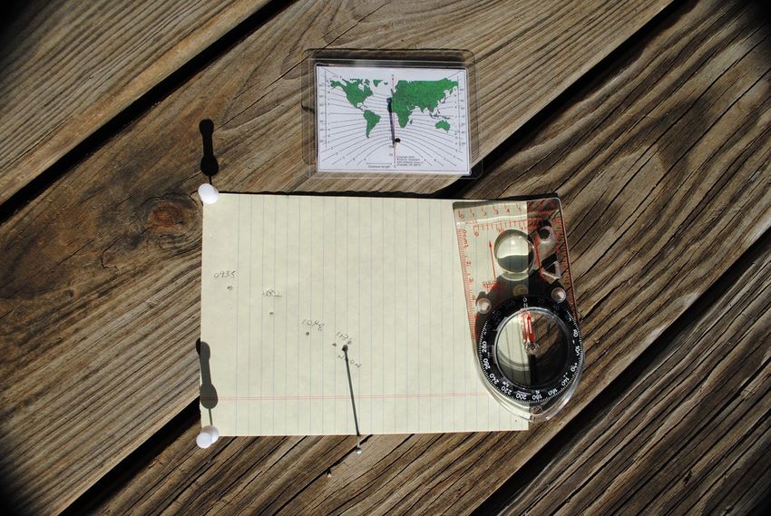
Free mapping site that provides USGS-derived topographical maps for any location and at any
scale chosen by the user.

Stellarium (stellarium.org)

Astonishingly powerful (and free!) planetarium software that duplicates and animates the
appearance of the sky for any date, time and location. Available for Mac, iOS, Linux, Windows
and Android platforms. An hour or so spent exploring the sky with Stellarium will familiarize the
user with the appearance and movement of celestial bodies and the changing appearance of
the night sky with the seasons. It also provides astronomical data that can be used for
determining position and direction.

Star Walk

A powerful, inexpensive iOS planetarium app with many of the same functions as Stellarium.

Celestial

An inexpensive navigation app available for mobile platforms and home computers that
provides almanac data, sight logging, sight reduction and plotting for formal celestial
navigation. Accurate and easy to use. Substitutes for 20 lbs. of books and tables.

msi.nga.mil

The National Geospacial-Intelligence Agency online site with a free download of Bowditch (The
American Practical Navigator) in .pdf format. Back in the day in the Western world, the only
two books that were felt to be essential on a sailing vessel were The Bible and Bowditch!
Bowditch contains an encyclopedic explanation of all aspects of navigation - celestial, coastal,
and electronic. It also has essential tabular data covering any aspect of navigation that can be
imagined (including a very useful table of amplitudes). Over 1000 pages long in hardback, and
a bargain if interested in navigation history or practice. Literally everything you need to know.

Owendoff, RS. Better Ways of Pathfinding. Stackpole Publishing, Harrisburg, PA, 1964.

Now out of print, but available in libraries and from used booksellers, this book has excellent,
practical advice for field-expedient celestial navigation and includes the original Universal
Pocket Navigator, an unparalleled aid for direction-finding based on Sun shadows.

Carleton, SC: Wilderness navigation and techniques. In: Auerbach’s Wilderness
Medicine, 7th Ed., Elsevier, Inc., Philadelphia, 2017.

Discusses satellite navigation, celestial navigation, map and compass navigation, and methods
for field-expedient navigation when instruments are lacking. Includes a copy of the Universal
Pocket Navigator.

Burch, D. Emergency Navigation, 2nd Ed., McGraw-Hill, Camden, MN, 2008.

Comprehensive coverage of emergency navigation techniques at sea with excellent
illustrations. Many of the techniques described are also applicable to land navigation.

Seidman, D. The Essential Wilderness Navigator, Ragged Mountain Press, Camden, MN,
2001.
Clear, concise treatment of map reading and compass use, and a small section on celestial
techniques. Includes a very useful figure and table for determining the amplitude of the Sun
graphically…this diagram could even be drawn in the dirt to estimate true direction from the
rising or setting Sun.

Glossary
Altitude - angular height of a body above the true horizon.
Amplitude - angular distance from due East (rising), or due West (setting), of a body on the
      horizon.
Aries - The hour angle of the geographic position of the Sun at the sate/time of the vernal
      equinox. Used as a reference point for the sidereal hour angles of stars.
Azimuth - bearing of a body measured 0o - 360o from true North.
Celestial equator - projection of the terrestrial equator out to the celestial sphere.
      Declination of the celestial equator = 0o.
Celestial poles - projections of the Earth’s axis of rotation out to the celestial sphere. The
      declinations of the poles = 90o North or South.
Celestial sphere - artificial sphere centered on the Earth.
Declination - angular distance above/below the celestial horizon = celestial latitude.
Ecliptic - path on the celestial sphere followed by the Sun and planets.
Hour angle - angular distance in reference to a meridian = celestial longitude.
LAN = Local Apparent Noon - when the Sun is on the observer’s meridian.
Meridian - circle on the celestial sphere bearing due North/South.
Zenith - straight up. A point on the meridian with a declination equal to the observer’s
      latitude.
Field-Expedient Celestial
Navigation
Steven C. Carleton, MD, PhD
Department of Emergency Medicine
University of Cincinnati
25 February 2021Staying Found Navigation: Fixing position. Dead [deduced] reckoning (planning and tracking the progress of travel): - Determining direction. - Estimating distance.
Overarching Objectives
Demonstrate methods of pathfinding that:
  1) Are practical and self-contained.
  2) Require no technology.
  3) Can be fabricated on the fly and carried in a pocket.
  4) Can augment and correct map and compass
     navigation.

       * Assumes some knowledge of the day and night sky, how
        celestial bodies move, and ability to estimate angles.
Specific Objectives Direction by the sun (shadow tip methods/sun compasses). Direction by amplitudes using any known celestial body. Direction by conspicuous or easily identified stars.
Ancient History

                                                        Polynesian "star
                                                          compass" based
                                                          on rising and
                                                          setting points.

From: https://movin2newzealand.wordpress.com/2015/12/15/polynesian-navigation-2/
Ancient History Viking Sun Compass 900 CE
Bumstead Sun compass

              Recent History

                                             Apollo Sun compass

Abrams Sun compass

                       Sperti astrocompass
Study the Night Sky Lat: 39o 13’ N 02/25/2019 Long: 84o 29’ W From Stellarium Sunset
Study the Night Sky

                      Lat: 40o N
                      02/25
                      1900 Local
Star Paths
Cincinnati, OH
Latitude = 39o
Rising/setting angle = 51o
Sun Surveyor
Rising and setting angles = co-latitude [90o - lat]Directions from the Sun - I Shadow Method: The direction of the Sun will change throughout the day. The altitude of the Sun will change throughout the year. The altitude of the Sun will change with the latitude of the observer. All of this is predictable and easily determined.
The Sun’s Path

   Cincinnati, March Equinox             Cincinnati, June Solstice

Cincinnati, September Equinox        Cincinnati, December Solstice

                                                                     Sun Surveyor
Cincinnati, Today
E
*
*
W Sun Surveyor
o
*Amplitude = 110907
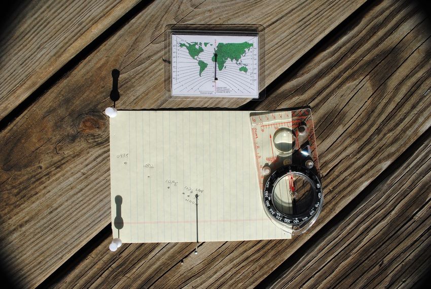
0946
Shadow Tip
Method
Declination curves
The tip of the shadow cast by an
object over the course of the 0946
0957 1040
day follows a curve that is 1128
specific for the declination of 1200
the Sun on that date, and the
latitude.
The morning and afternoon
portions of the curve will mirror
one another.Shadow Tip Method
A line drawn between the point of closest approach of the declination
curve to the gnomon (LAN) is a true North-South line.
True North
0907
0931 0957 1040 1707
1200 1321 1425
Civil noon line
. LAN
True SouthShadow Tip Method
A circle centered on the gnomon will intersect the declination curve at
two points. A line between these points is a true East-West line.
True North
0907
1707
True West True East
. LANSun Compass
0935 1002 1048
1136 1200 1321 LAN
Derive the declination curve by tracing the shadow tip over several hours.
The shortest shadow at LAN will point due North-South.Sun Compass Valid within +/- 100 mi. of this latitude for several days
UPN
Chart to determine gnomon
  placement and declination
  curve to use for a given
  latitude and date

Declination curves
Gnomon location
Gnomon length

 Adapted from: Owendoff, RS. 1964
True vs. Magnetic North
18 October              True North   Magnetic North

N 39.222o, W 084.487o
Direction by Various Methods
A = Watch North                                   B
                                                      C

B = Compass North                             A

C = True North
                                      1000
       True North

 **
                      True East

           .        Eastward

                             1005 EDT 10/22
Limitations of Methods
Note: The UPN* is accurate, without limitations
*
and with UPN
Mag. Declination 6o E
From: Owendoff, RS (1964) = 11% error per mileDirections from the Sun - II Amplitude Method: The amplitude of any celestial body is the measurement in degrees between the rising or setting point of the body and due East (rising) or due West (setting). Amplitude is accurate and predictable if the latitude of the observer and the declination of the celestial body are known. Determine the amplitude, observe the rising/setting point of the Sun, and the cardinal directions can be established.
Sunrise Over a Solar Year

            E
Finding the Amplitude
Napier’s Rule:
Amplitude = sin-1 (sin d/cos L)
d = declination of body (+ if North, - if South)
L = latitude of observer (+ if North, - if South)
- or -
Table 22 [27] Bowditch
- or -
Estimate by diagramFinding the Amplitude
Sunrise, Cincinnati, 02/26
By Napier’s rule:
Amplitude = sin-1 (sin d/cos L)
= sin-1 (sin -8.5/cos 39.2)
= sin-1 (-0.1478/0.7747)
= sin-1 (-0.1908)
= -11o [11o South of East]
Azimuth = 101oFinding the Amplitude From Table 22 [27], Bowditch
Finding the Amplitude
                    Latitude        5 10 15 20 25 30 35 40 45 50 55 60
                    Max. Amplitude 24 24 24 25 26 27 29 31 34 38 44 53

                                     Aug.
                                                   Sept.    E           Oct.

                                                                                   Nov.
Date: 25 February        July
Lat: N 39o                              Max. amplitude
                                       for latitude N 39o
                                            = +/- 31o           Amplitude
Estimated                                                         - 11o
                                                                                     Dec.

amplitude = - 11o        N                                                            S
(S of E)                June
                                31    24      16     8

Calculated                                                                          Jan.
amplitude = -10.9o
                          May

                                                                            Feb.            Adapted from: Seidman
                                           Apr.
                                                            W   Mar.                              1995/2001
Sunrise, June Solstice
X = Amplitude = 31o North of East
E
X
From Star WalkSunrise, Equinoxes
Amplitude = 0o, Y = rising angle = 90o - latitude
Y
E
From Star WalkSunrise, December Solstice
X = Amplitude = 31o South of East
E
X
From Star WalkMeasuring Angles
1. Along the horizon to find cardinal directions
from amplitude:
- hand/finger spans
2. Above the horizon to find rising/setting point:
- hand protractorEstimating Angles by Finger
SpansFind Your Own Angles
1.5o 2.5o 4.5o 10o
12o 15o 19o 4.5o 2.5o
2oReference Angles
8oMeasuring
Angles of Arc
Arab Kamal
At a distance of 57 cm
o
1 cm = 1 of arc.
At a distance of 28.5 cm
o
1 cm = 2 of arc.Direction by Sun Amplitude
18 December, 0753 EST
o o
N 39.222 , W 084.487
o o
Calculated amplitude = 30.3 S of E, Finger span amplitude = 31
Azimuth = 90o + 30.3o = 120.3o
19o 12o 12o
ERising/Setting Angle
Rising/setting angle = (90o – latitude) = 51o.
Rising angle
Rising pointHand Protractor
90o 51o
33o
17o
0oHand Protractor …for measuring angles relative to the horizon (rising/setting angles)
Tracing back to Rising Point
                                 o                   o
     27 December, Latitude N 39 , Co-latitude = 51
                      o                               o
    Solar amplitude 30 , Solar azimuth at Sunrise 120

                                               51o

E
Directions by Stars & Planets
Direction by Amplitude
Any celestial body can be used to establish
 cardinal directions if:
  - you know the declination of the body
  - you know your approximate latitude
                       - and -
    - you can observe or estimate the rising/setting
       point of the body
Direction by Star/Planet Amplitude
Identity of body, declination, latitude
Regulus setting
o
Declination = N 12
o
Latitude = N 39
Setting angle (x) = 51o
o
Amplitude = 15 N of W
Azimuth of setting point = 285o
o
15 x
WDirections by Zenith Stars
West
EastDirections by North Circumpolar Stars
x
2y
5x
y
From Star WalkDirection by South Circumpolar Stars
X
From StellariumDirections by Orion - I
Setting angle = Co-latitude = 51o From Star WalkDirections by Orion - II
Line from Alnilam to “sword”
SDirections by Scorpio
From StellariumWhat to Carry UPN, paper clip, protractor, cm ruler, string, pin, magnifier, tin foil, knife, pen, pencil, USGS map, paper, button compass, bubble level, amplitude calculator, matches, $20, ID. 3x5 card with zenith stars, Sun/Moon/stellar/planetary declinations & amplitudes, LAN, magnetic declination, zone time offset, latitude, max. amplitude for latitude, times of rising and setting of the Sun/Moon/relevant stars/planets.
?
You can also read