FOREST MONITORING IN PORTUGAL - EARSC
←
→
Page content transcription
If your browser does not render page correctly, please read the page content below
FOREST MONITORING IN PORTUGAL

Copernicus Sentinel data and AI are being
used to provide continuous forest inventories
in Portugal, identify land use (changes) as well
as check upon the health status of trees in
support of forest managers and the pulp
& paper industry.

THE CHALLENGE
You may not be aware, but the pulp and paper industry has a very high importance to the Portuguese economy! The
main players of the processing industry directly manage around 200,000 ha of (mainly eucalyptus) forests and tree
plantations in Portugal, covering c. 20% of the industry’s demand for wood – the basis for the huge pulp and paper
production facilities. The remaining is coming from both the domestic market including small-scale forest owners (55%)
and imports (25%). As the tree plantations are dispersed all over the country, it is expensive and time-consuming
to monitor their lifecycle growth. On top of that, in recent years, Portugal has been home to an increasing number
                                           of wildfires that, additionally to their dramatic human cost, are presenting
                                           a risk to plantations and to the constant supply of raw materials for the
                                           pulp and paper mills. Regulations imposed by the government on some of
                                           the production forests, namely eucalyptus, demand new tools and more
                                           information to manage the forest actively and sustainably.
                                         In this context, CELPA, the Portuguese pulp and paper industry association,
                                         and its member companies have started a collaboration with Tesselo. This
                                         Lisbon-based European start-up delivers continuous forest inventories
                                         powered by AI, allowing to monitor tree health status, identify land use
                                         and land use changes all over the country to monitor forest dynamics and
                                         understand more effectively market gaps and import needs. As such, the
                                         service is provided to CELPA as well as to its various members, most of which
                                         are leaders of the global pulp and paper market and make up 90% of the
                                         Portuguese paper industry. In times of the Covid pandemic and associated
                                         counter-measures that came along with it especially, the solution provided
                                         by Tesselo helped users “keep a holistic eye” on the plantations throughout
                                         the country, monitor tree growth and understand where wildfires might have
                                         ravaged trees, necessitating further action.

                                                                                             More information on
January 2021                                                                                 www.earsc.org/sebs
FOREST MONITORING IN PORTUGAL

HOW SATELLITES CAN HELP
                                                                                                                        The satellite data:
Forest management and inventory is, traditionally, an extremely
demanding work for forest managers, necessitating frequent field
inspections and/or aerial surveys of the plantations on a regular basis
to keep information updated. Because of its extensive workload and
associated cost, the Portuguese National Forest Inventory for instance
is only updated every 5 years. By contrast, optical satellite imagery,
acquired in this case from Sentinel-2, coupled with AI models, provides
extremely useful information about land use (changes) and status of
the tree plantations over the whole of Portugal on a weekly basis.
                                                                                                                        Sentinel-2 carries an innovative wide swath
In light of these benefits, Sentinel-2 data was chosen to form the                                                      highresolution multispectral imager with
backbone of the service provided by Tesselo. Being able to access a                                                     13 spectral bands. The combination of high
great database of historical in-situ measurements provided by CELPA                                                     resolution, novel spectral capabilities, a
and the individual member companies, Tesselo was in the position                                                        swath width of 290 km and frequent revisit
to draw from excellent training and verification data i.e. field data                                                   times provides unprecedented views of
and develop AIbased algorithms that are able to process the vast                                                        Earth. Sentinel-2 images can be used to
amount of EO data and determine tree health, land use and land                                                          determine various plant indices such as
                                                                                                                        leaf area, chlorophyll and water content,
cover, environmental threats and many more features that ultimately
                                                                                                                        providing information useful for agricultural
deliver the actionable insights to the users that make the solution so                                                  and forestry practices and for helping
powerful. The diversity and geographical spread of CELPA members                                                        manage food security. Sentinel-2 also
was invaluable to build high-quality samples to train and test models.                                                  provides information on pollution in lakes
In addition, the close collaboration led to a better understanding of                                                   and coastal waters.
market needs and finer calibration of the Tesselo services and in turn                                                  Images of floods, volcanic eruptions and
impacted on their strategic R&D planning.                                                                               landslides contribute to disaster mapping
The application itself is accessible through an automated web platform                                                  and help humanitarian relief efforts.
– through API and WMTS – while reports are provided to CELPA and                                                        Copernicus Sentinels data are available
its member companies on a monthly basis. Whilst R&D is continuing                                                       under an open and free data policy.
in close cooperation with CELPA and further features will be added in
the near future, the Sentinel-based application currently provides the
                                                                                                                        Sentinel-1 data can be accessed at
following information features for end users:                                                                           https://scihub.copernicus.eu
• C lassification of (national) land use: classification of the whole country                                          More info: https://sentinels.copernicus.eu
   land into customizable classes (agriculture, forest, shrubs etc.) and
   monitoring of change over time
• I dentification of tree species (eucalyptus, cork oak, holm oak and 3
  categories of pines)1
• Tree characterisation: age (and soon timber volume)
• L ife cycle monitoring: continuous detection and measurement of
  new plantations, harvested areas & burnt areas to optimize forest
  management operations
   ree health: flagging of health anomalies by monitoring of leaf
• T
  moisture, leaf area index and chlorophyl level

1. T
    hrough previous projects, Tesselo is also skilled in detecting and monitoring other vegetation/crop/tree species
   including pepper fields (in Brazil), mangrove (in Madagascar), Almond trees (in Costa Rica), sugar cane (in
   India), sandalwood (in Australia).

                                                                                                                                           More information on
January 2021                                                                                                                               www.earsc.org/sebs
FOREST MONITORING IN PORTUGAL
Certainly, one of the main advantages of using the Sentinel satellites
is its frequent global coverage and thus the provision of fresh data and The Service Provider
updated insights over the Portuguese tree plantations every 5 days; Tesselo, an innovative start-up from
a frequency that could never be achieved with other remote sensing Lisbon, Portugal, is an environmental
methods, let alone field visits, at this low cost per hectare and with this technology firm specialised in spatial
regularity. The ability to have easily accessible frequent and synoptic intelligence. Founded in 2017, the
views over the plantations is a great advantage that provides timely and multilingual team spread over three
full information matching the specific needs of CELPA and its members. continents engaged in a 2-year R&D
collaboration process with CELPA and
CELPA in itself is interested in rather large-scale market developments
has been supported by grants coming
in Portugal in support of its market analyses while individual member from ESA and EC i. a. Working solely with
companies are seeking timely and efficient information at parcel level. open spatial data from the Copernicus
Furthermore, thanks to satellite data archives (Sentinel-2 goes back to program, Tesselo is able to deliver
2015, but can be complemented with Landsat data going back decades), costeffective solutions for any natural
companies can look up historical information of the tree plantations. resource stakeholders.
Since the majority of Portugal´s tree plantations are non-industrial
The company’s core business rests
privately owned, historical knowledge and experience may be lacking. on the augmentation of open satellite
Historical satellite data can shed light on which potential areas can imagery with artificial intelligence. Their
provide the biggest timber volumes and thus return of investment. main target markets are the forestry,
Moreover, using satellite data is a non-intrusive method of retrieving infrastructure and insurance.
information i.e. in-situ data and field inspections are not permanently
necessary, while seasonal and long-term trends can be monitored.
With relation to the health status of trees and pest prevention, satellite
data is able to provide insights days before the forest manager would www.tesselo.com
have observed any stress or disease. Because Sentinel-2 sensors cover a
wider electromagnetic spectrum than the human eye, with the help of AI,
Tesselo can uncover more details and information about tree health than
otherwise possible. As a result, forest managers are able to step in days
in advance and focus on plantations where their care is most needed.
The temporal resolution, i.e. frequency of fresh imagery, is sufficient to
monitor changes and take appropriate measures in a timely manner.
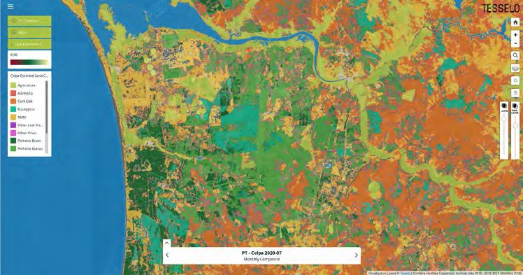
Land use classification interface ©Tesselo
More information on
January 2021 www.earsc.org/sebs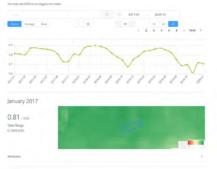
FOREST MONITORING IN PORTUGAL

                                      TIER 1                 TIER 2                  TIER 3                     TIER 4

                                                      Land use map, tree                                 Improved forest
                  Services      Satellite imagery                             Tree health maps           management &
                                                        characterisation
                                  (Sentinel-2)                                     (NDVI)                  reduced risk
                                                       (age and volume)                                     of wildfires

                                                                            Secondary Beneficiary:
                                                                                                      End User Beneficiary:
              Beneficiaries     Service Provider:        Primary Users:       Forest managers
                                                                                                            Citizens
                                    Tesselo                  CELPA              of the paper
                                                                                                         and business
                                                                                  industry

                                                                               Actors (agencies, ministries ect.) involved in
                                                                              territorial planning, environmental protection,
                                                                                      civil protection, wildfire fighting.
                                                                                Research institutiuons can use and benefit
                                                                             from the Tesselo service for research purposes.

Schematic representation of the main beneficiaries along the value chain, including the corresponding services and benefits provided

WHO IS CONCERNED?
CELPA (Associação da Indústria Papeleira) is the association of the
Portuguese pulp and paper industry and represents the interests of                     The Primary Users
its member companies Altri, DS Smith, Renova and The Navigator                        CELPA, the trade association of the
Company. It also promotes relations with other industry sectors and                   Portuguese pulp and paper producers,
looks out for new technologies that may be of interest to the sector                  was founded in 1993 from the merger
such as satellite Earth Observation. Its members produce 100% of                      between ACEL (pulp) and FAPEL (paper
the Portuguese pulp and some 90% of the Portuguese paper. To                          and board). The members of CELPA are
monitor national forests, as a source of raw material, CELPA needs as                 14 industrial and forestry companies
much information on the eucalyptus and maritime pine plantations as                   and together they produce 100% of the
possible to plan strategically and support its members.                               national virgin fibre paste and about 90%
                                                                                      of all paper and board. CELPA’s members
This information can be drawn from analysing Sentinel-2 images                        directly manage 193,200 hectares of
through which developments such as tree extent, cut/burnt areas,                      forest in their own and leased properties.
distance to settlements etc. can be provided. Reports are produced by
Tesselo on a quarterly basis, a frequency often enough to understand
changes in these parameters.
The forest managers of the paper companies usually spend their time
out in the forests. Their picture of the situation of the plantations can
however never be complete as the plantations can be in remote regions
and there are simply too many to have a holistic picture. Experience,
knowledge, and intuition has to tell them where to go next. To make
more informed decisions, the application provides them with updated
information on tree health updated every few days so that field
                                                                                                         www.celpa.pt
inspections can be prioritised according to where their work is needed
the most. The application, moreover, gives the forest managers an
idea about the potential of new plantations and how a newly leased
plantation has been doing in the past.

                                                                                                              More information on
January 2021                                                                                                  www.earsc.org/sebs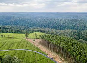
FOREST MONITORING IN PORTUGAL

WHAT ARE THE BENEFITS?
CELPA considers that the use of AI-powered Sentinel data is a “gamechanger” to the pulp and paper industry in Portugal
and that its use has been facilitating and benefiting the industry considerably already in the short time it has existed.
While Tesselo’s R&D activities are continuing in close cooperation with CELPA and further features will be added in
the near future to the platform, it is already delivering valuable insights that otherwise would have been difficult to
materialise.
CELPA is now in the position to monitor land use throughout Portugal, and specifically the national eucalyptus and
maritime pine forests in a much more cost-effective way. To check and monitor forests and tree health and care, CELPA
and member companies 25% on average in trips to often remote areas all over the country. This type of monitoring can
be done now from a mobile device or laptop. This freed-up time can be used in a more productive way (and long trips
are saved). Knowing monthly accurate forest information gives companies an effective tool and “strategic intelligence”
to do their planning and logistics more effectively for pulp and paper production.

  The key benefits are:

                     Economic
                     • increased employment (tier 1)
                     • efficiency gains and cost savings due to needs-based field inspections by at least 25% (tier 2/3)
                     • increased revenues due to better tree care and maintenance increasing the yield (tier 3)
                     • increased revenues due to early warning system in the future (tier 3)

                     Environmental
                     • reduced pollution due to decreased use of fertilizer/pesticides (tier 3)
                     • reduced pollution due to 25% less car trips (tier 2/3)

                     Regulatory
                     • improved monitoring of protected/at-risk forest areas (tier 2/3)

                     Innovation & Entrepreneurship
                     • creation of a new, profitable business (tier 1)
                     • changed, more efficient business practice (tier 2/3)

                     Science & Technological Research
                     • increased student research on EO due to partnership between Tesselo and universities (tier 3/4)

                     Societal
                     • contribution to the sustainability of the forests and of the pulp and paper industry (tier 3)
                     • contribution to secure a competitive advantage for the Portuguese pulp and paper industry (tier 3)

                                                                                                  More information on
January 2021                                                                                      www.earsc.org/sebs
FOREST MONITORING IN PORTUGAL
NDVI time series provided in the application ©Tesselo
EXTENDED IMPACT
This type of satellite image analysis is not interesting only to industrial players and trade associations. Governments
and public agencies may well be interested in forest inventories, tree classifications, automatic checks of environmental
regulation compliance or deforestation alerts.
Furthermore, the data and analytical techniques used in this case are applicable globally. Sentinel images provide global,
periodic coverage and the need for forest monitoring, land use changes or tree health monitoring are becoming ever more
important given the need for environmental protection and the relevance of forests in the fight against climate change.
After calibration, the application of the algorithms to other geographic regions have already shown high performances
and could thus be used in regions where for instance forest monitoring is an important issue.
Building on the work done and with the integration of further features, Tesselo has started to apply its vegetation and
forestry expertise to other user markets challenged by natural resource management such as utilities for vegetation
management around critical infrastructure and insurance companies, targeting climatic risk-related lines of business.
Aiming for a full self-service platform in the future, the distribution of Tesselo’s services will be greatly facilitated.
More information on
January 2021 www.earsc.org/sebsFOREST MONITORING IN PORTUGAL
ABOUT THE PROJECT
The Sentinel Benefits Study (SeBS) is conducted by EARSC (European
Association of Remote Sensing Companies) with partners The Greenland,
IIASA (International Institute for Applied Systems Analysis) and
Evenflow on behalf of the European Space Agency (ESA). It has the goal
to study 20+ full cases by analysing the impact of the use of Sentinel
data along a valuechain.
This short-case has been prepared where there has been an interesting
use made of Sentinel data, but it has not (yet) been possible to conduct
a full case. It tells the story of the use of Sentinel data without going
deeply into the economic or environmental benefits.
“ For the Portuguese pulp,
paper and cardboard industry,
it is extremely important to
We acknowledge that the understanding of the case was supported by discussions
know exactly the areas and
with Rémi Charpentier and Marine Utgé-Royo from Tesselo as well as Francisco
Goes from CELPA. We thank them for their valuable insights and availability. stocks of the eucalyptus and
pine forests on a national
scale, pointing to the need
Do you know an interesting case demonstrating the
for constant updated forest
benefits derived from the use of Sentinels data?
information. The development
Email info@earsc.org of a service for monitoring
More Information on Sentinels Benefits Studies: the evolution of the national
forest in mainland Portugal,
www.earsc.org/sebs
based on the automatic
classification of satellite
images from Sentinel-2 is a
major breakthrough for the
industry because today there
The Sentinels Benefits Study is funded by the EU and ESA.
is, on a regular and periodic
The views expressed in this study cannot be taken to reflect the official position basis, access to up-to-date
of the EU or of ESA. information on the evolution
of land use, i.e. new forests,
harvested and burned areas.
Francisco Goes, Forest & Statistics, CELPA
”
More information on
January 2021 www.earsc.org/sebsYou can also read