Linking flood impact forecasting and satellite rapid mapping in Europe
←
→
Page content transcription
If your browser does not render page correctly, please read the page content below
Linking flood
impact forecasting
and satellite rapid
mapping in Europe

Francesco Dottori, Milan Kalas, Peter Salamon,
Annett Wania, Ines Rivero (EC JRC)
               Copernicus EU   Copernicus EU

               Copernicus EU   www.copernicus.eu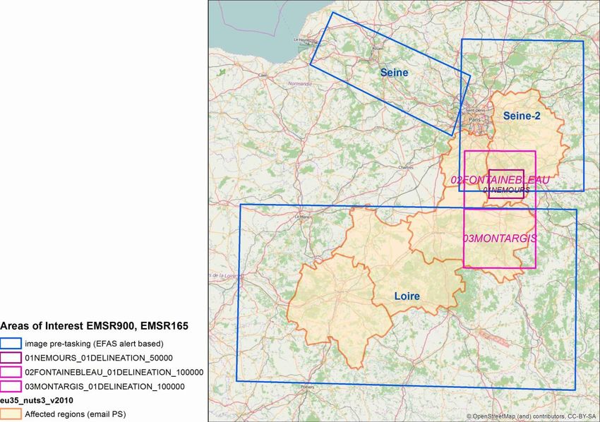
Copernicus          Programme
 Emergency
Management
             •   It is the European Union's Earth Observation Programme,
             •   It offers information services based on satellite Earth Observation, models,
                 and in situ (non-space) data
             •   Copernicus Emergency Management Service (EMS) provides information
                 (with a global reach) for emergency preparedness, response and recovery
                 activities in relation to natural and man-made disasters.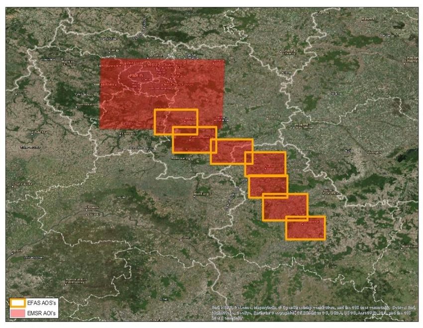
Copernicus EMS - EFAS
Emergency
Management
European Flood Awareness System
Objective: Provide complementary, added value flood early
warning & monitoring products to improve the
preparedness and emergency response of national
stakeholders (e.g. hydrometeorological services)
Products:
different forecasting &
monitoring products (ensemble
river flood forecasts, flash flood
forecasts, impacts etc.)
Available through web interface
or OGC web services (WMS-T &
SOS)
Copernicus               EMS    -   Rapid            Mapping             (RM)
 Emergency
Management
                 •    Mapping information of disaster events for emergency response
                 •    Fast delineation of flood extent from satellite imagery
                 •    24/7/365 on-demand service
                                                                                        Image data provision
             Crisis
                  Mapping
                 Authorised
                                 Service         ERCC                           Service
                                 Request         Criteria check                activation
                    User

                                                                                     Service Provider
                                                                  SFTP
                                                                  EMS Portal         Product specification &
                                                                                     Satellite image ordering
                           Service                                                   Production
                           delivery                                                  Map delivery
                                                                                4
Linking       Early        Warning            and      Rapid        Mapping
 Emergency
Management    Motivation
              •   Reduce time for image acquisition (66% of RM workflow)
              •   Optimise acquisition time with respect to event time
              •   improve timeliness of map production through pre-alerting
                  of potential RM activations for flood events (pre-tasking of
                  satellites)
              How?

                                                                            5
Linking                Early    Warning   and   Rapid   Mapping

 Emergency
Management         Flow forecast

                 Identify river reaches
             potentially affected and local
               flood magnitude for any
               event forecasted by EFAS
Linking                Early    Warning   and   Rapid   Mapping

 Emergency                                                                Rapid flood
Management         Flow forecast                                           mapping
                 Identify river reaches                                 Calculate flood-prone
             potentially affected and local                                   areas (using
               flood magnitude for any                                   catalogues of flood
               event forecasted by EFAS                                 maps and protection
                                                                          levels) and derive
                                                                            forecast-based
                                                                           inundation maps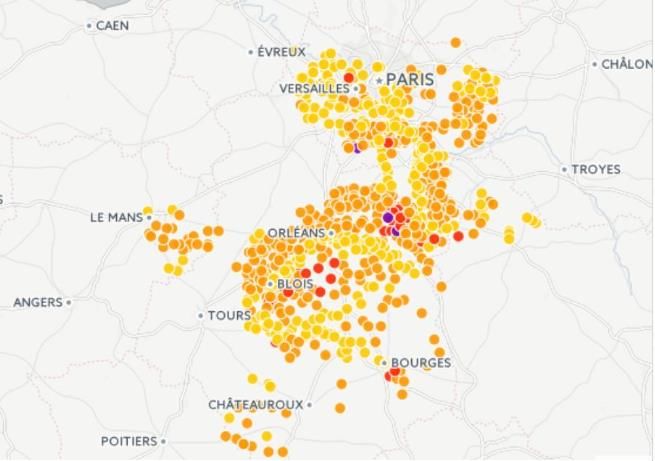

             Impact assessment

           Combine hazard maps with
         exposure (pop. – landuse) and
            vulnerability information
             (damage functions) to
          evaluate affected population
              and urban areas, and
               economic damage
Linking                Early    Warning   and   Rapid   Mapping

 Emergency                                                                   Rapid flood
Management         Flow forecast                                              mapping
                 Identify river reaches                                   Calculate flood-prone
             potentially affected and local                                     areas (using
               flood magnitude for any                                     catalogues of flood
               event forecasted by EFAS                                   maps and protection
                                                                            levels) and derive
                                                                              forecast-based
                                                                             inundation maps

             Impact assessment                                          Satellite pre-tasking
                                                                        Areas with high potential
           Combine hazard maps with                                     impact are identified and
         exposure (pop. – landuse) and                                     used to pre-task and
            vulnerability information                                    prioritize acquisition and
             (damage functions) to                                        processing of satellite
          evaluate affected population                                 images for monitoring flood
              and urban areas, and                                                 events
               economic damage
Linking         EFAS               and   RM:           Procedure
 Emergency
Management
                – Pre-tasking maximum 24 hours before the predicted event
                – Service available only for authorized users (Emergency Response Coord.
                  Centre (ERCC – EFAS partners…)

                                                               Rapid Mapping availability (incl.
                            EFAS                                                                   EFAS partner
                                                               activation procedure)

                 Alert (expected time,
                 peak, affected area)
                                                                                  Pre-tasking
                                                      ERCC
                                                                                  activity

                                                                                                     Rapid
                                                                                                    Mapping
                      Rapid Mapping                                                                Authorised
                                                                                                      User
                Satellite             Map
                tasking            production                        Scheduled image acquisition
                                                                     time & area

                                                                                          10
                                                  Legend:   Actor    Tasks      User
Linking EFAS and RM: Procedure
Emergency
Management Development and status
• 2015-2016: Development of the procedure for test cases (e.g. Balkan
floods 2014, Ebro floods February 2015)
• 2016: Testing in pre-operational mode(France floods 2016, Romania
2016)
• 2017: Finalization of the procedure
• 2017- Now: notifications for RM pre-activation sent for 5 river flood
events with 3 requested RM activations (France flood 2018, Albania,
Spain)
11France Floods June 2016
Emergency
Management From end of May until beginning of June 2016
Mainly affecting Seine and Loire river basins
Estimated total cost of 1.3 billion euro
and 172,000 people having declared
damages
12France Floods June 2016
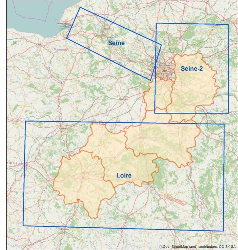
Emergency
Management Areas of Interest for
pre-tasking of satellite images
EFAS impact forecast (30th May)
Image pre-tasking (30th May)
13France Floods June 2016
Emergency Comparison of AOIs:
Management EFAS impact forecast (30th May)
Image pre-tasking (30th May)
RM user defined AOIs (1st June)
• Very good correspondence between pre-
tasked AoIs, user request and affected
areas....
• ....but image acquisition was delayed by
communication problems
14France Floods January 2018
Emergency
Management Mainly affecting Seine river basin and the Paris area (as in 2016 floods,
but with lower impacts)
1. First image (Sentinel-1) acquired on 22/6.
2. Radarsat images requested on 22nd and acquired on the 23rd.
3. First map produced on the 24th at 00:56
Sentinel-1 Radarsat-2 Expected peak Activation start
EFAS warning SPERF acquisition
acquisition
22/01/2018 22/01/2018 23/01/2018 23/01/2018 23/01/2018
22/01/2018
09:47 10:45 17:27 12:00 19:17
05:49
15France Floods January2018
Emergency
Management Proposed pre-tasking was actually requested by French authorized users
Flood monitoring with RM requested also for areas downstream of Paris
16Procedure
Emergency
Management Outlook
• Positive results from the EFAS-RM integration: significant time gain is
possible
• Raise awareness on user side about time gaps between request for
mapping and actually possible image acquisitions
• Connects EFAS and Mapping communities improved decision tools for
emergency response
• Expansion to the global scale (GloFAS-RM)
17Questions &
Comments?
Emergency ManagementYou can also read