North-West of Jones Bank Site Recommended Marine Conservation Zone
←
→
Page content transcription
If your browser does not render page correctly, please read the page content below
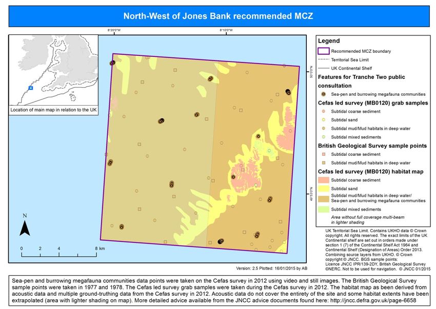
Department for Environment, Food and Rural Affairs

North-West of Jones Bank Site
Recommended Marine Conservation Zone
January 2015

Consultation on Sites Proposed for Designation in the Second Tranche
of Marine Conservation Zones

Sea pen and burrowing megafauna communities © Sue Scott JNCC           1
Contents

Where the site is located...................................................................................................... 3

How to comment on the consultation ................................................................................... 3

Why the site is environmentally important............................................................................ 4

What this site would protect ................................................................................................. 4

Where the features are located ............................................................................................ 5

Activities which are likely to be affected ............................................................................... 6

   UK commercial fishing...................................................................................................... 6

   Non-UK commercial fishing .............................................................................................. 6

   Cables .............................................................................................................................. 7

   National defence .............................................................................................................. 7

Activities that are unlikely to be affected .............................................................................. 7

Additional Information .......................................................................................................... 7

                                                                                                                                        2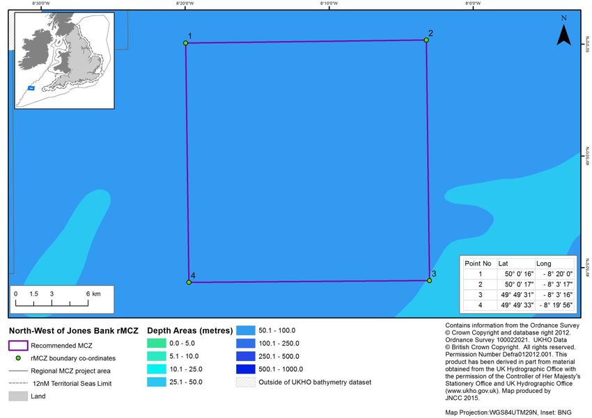
Where the site is located
North-West of Jones Bank recommended Marine Conservation Zone (rMCZ) is an offshore
site approximately 165 km west of Land’s End and has an area of 464 km2.

How to comment on the consultation
You can comment on this proposal by responding to the consultation taking place between
30th January and 24th April 2015.

                                                                                          3
Why the site is environmentally important
This site contains two features which fill network gaps - sea-pen and burrowing megafauna
communities, and subtidal mud.
Subtidal mud is an important habitat for a number of species including worms, cockles,
urchins and sea cucumbers. Burrowing fireworks anemones and brittlestars can also be
found as well as luminous sea-pens which protrude from the surface of the mud.
Designation of this site will also protect subtidal sediment habitats, which support a range
of burrowing animals such as worms and shrimps, as well as scavenging animals that
occupy the surface of the seabed such as crabs and fish. North-West of Jones Bank has
also been identified as an important nursery and spawning area for fish.
What this site would protect
Designation would protect the following features. You can read more about the features
this site protects and why they are important here.
Feature General management approach
Subtidal coarse sediment
Subtidal mixed sediments
Subtidal sand
Subtidal mud Recover to a favourable condition
Mud habitats in deep water
Sea-pen and burrowing megafauna
communities
4Where the features are located
The following map shows the location of the features to be protected. A range of different types of surveys have been used to create this
map. More detailed information on the techniques used and the features themselves can be found here.
5Activities which are likely to be affected
Management decisions are taken on a case by case basis by relevant regulators.
Management will not automatically mean that economic and recreational activities will be
restricted, decisions will be based on the specifics of each case. Restrictions on an activity
will depend on the sensitivity of species, habitats and geological/geomorphological
features (for which a site is designated) to the activities taking place in that area. More
detail is available in the Impact Assessment.
Sectors or activities likely impacted by designation
Best Cost Estimate (£)
Sector Activity Affected per year
Bottom trawls/dredges, 1,400
UK commercial fishing
static gears.
Vessels from France, Ireland and Unquantified
Non-UK commercial fishing
Spain
Future interconnectors and telecom Unquantified at site level
Cables
cables
National defence Use of training site Unquantified at site
level.
Best estimate total cost 1,400
UK commercial fishing
There is a low level of netting activity by UK vessels, however static gear are not likely to
be affected by management in the site. Bottom trawl activity from UK vessels also occurs
within the site and is likely to be affected by management in the site.
Non-UK commercial fishing
Non-UK fishing is known to occur throughout the site, with vessels using static gears,
bottom trawls/dredges and mid-water trawls within the site. Vessels from Ireland, France
and Spain are the main users of the site. It is likely that bottom trawl and dredge activity
will be affected by management in the site.
Although impacts outside the UK are not quantified as part of the impact assessment, the
implications of designation on non-UK commercial fishing vessels are considered in
deciding which sites to designate.
6Cables
Costs to the cables sector associated with management of second tranche rMCZs are
assessed on a regional scale, rather than individually for each site. This is because it is not
certain where cables will be built in the future, and where management will be required.
Where a new cable is laid in an rMCZ, the impact on designated features would need to be
considered as part of the licence application, which may entail an increased cost.
It is not anticipated that cables already in place will require any management measures
following designation.
National defence
The Ministry of Defence is known to make use of the site for training activities.
We expect this activity to be able to continue. Activity which is harmful to features can be
avoided though additional planning during operations and training.
Activities that are unlikely to be affected
These activities are known to take place at this site but are not likely to be damaging to the
features proposed for designation at their current levels of intensity:
commercial fisheries – netting,
existing interconnectors and telecom cables - one active cable intersects the site,
transit of ships.
Additional Information
To read the full consultation document, or respond to the consultation, please visit
https://consult.defra.gov.uk/marine/tranche2mczs
To read the advice provided by JNCC, please visit
http://jncc.defra.gov.uk/page-6658
For further information, please contact Defra on
03459 33 55 77 (UK only)
+44 20 7238 6951 (from outside the UK)
defra.helpline@defra.gsi.gov.uk
7© Crown copyright 2015
You may re-use this information (excluding logos) free of charge in any format or medium,
under the terms of the Open Government Licence v.3. To view this licence visit
www.nationalarchives.gov.uk/doc/open-government-licence/version/3/ or email
PSI@nationalarchives.gsi.gov.uk
This publication is available at www.gov.uk/government/publications
Any enquiries regarding this publication should be sent to us at
mcz@defra.gsi.gov.uk
PB 14275
8You can also read