Funding Guidelines FY 2017-2019 - Floodplains by Design October 2015 Publication No - Wetlands Watch
←
→
Page content transcription
If your browser does not render page correctly, please read the page content below
Funding Guidelines
FY 2017-2019

Floodplains by Design

October 2015

Publication No. 15-06-019
Publication and Contact Information
This document is available on the Department of Ecology’s website at:
https://fortress.wa.gov/ecy/publications/SummaryPages/1506019.html

For more information contact:
Shorelands and Environmental Assistance Program
Floods and Floodplain Management
P.O. Box 47600
Olympia, WA 98504-7600
Phone: 360-407-6131

Washington State Department of Ecology - www.ecy.wa.gov
o   Headquarters, Olympia                        360-407-6000
o   Northwest Regional Office, Bellevue          425-649-7000
o   Southwest Regional Office, Olympia           360-407-6300
o   Central Regional Office, Union Gap           509-575-2490
o   Eastern Regional Office, Spokane             509-329-3400

To request ADA accommodation including materials in a format for the visually impaired, call
Ecology at 360-407-6600. Persons with impaired hearing may call Washington Relay Service at
711. Persons with a speech disability may call TTY at 877-833-6341.

This page is purposely left blank
Table of Contents

CONTACT INFORMATION                                            VI

CHAPTER 1: PROGRAM OVERVIEW                                     7

CHAPTER 2: FUNDING PROGRAM DETAILS                             17

CHAPTER 3: ELIGIBLE PROJECT TYPES AND ACTIVITIES               21

CHAPTER 4: APPLYING FOR FUNDING                                26

CHAPTER 5: AGREEMENT DEVELOPMENT, MANAGEMENT, AND CONDITIONS   34

APPENDIX A: DEPARTMENT OF ECOLOGY REGIONAL OFFICES             43

APPENDIX B: MAP OF WATER RESOURCE INVENTORY AREAS (WRIAS) IN
WASHINGTON                                                     44

APPENDIX C: SCORING GUIDANCE                                   45

APPENDIX D: CULTURAL AND HISTORIC RESOURCES REVIEW GUIDANCE    55

APPENDIX E: GRANT AGREEMENT DEFINITIONS                        60

APPENDIX F: MEDIAN HOUSEHOLD INCOME                            61

APPENDIX G: PROJECT OUTCOMES METRICS TABLE                     75

APPENDIX H: SAMPLE PROJECT COMPLETION FORM                     78

APPENDIX I: EAGL & GRANTS TRAINING TOOLS AND RESOURCES         81

APPENDIX J: DRAFT FULL APPLICATION                             82

                                  Page iv
List of Tables & Figures
Table 1: Funding Appropriated by Washington State Legislature ............................................... 17
Table C-1: Application Scoring Guidance .................................................................................... 45
Figure D-1: Cultural Historic Resources Review Process ............................................................ 59
Table F-1: December 2018 American Community Survey 5-Year Estimates of Median
Household Incomes for Washington State, Counties, and Communities ..................................... 61
Page vContact Information
General Information/Program Scott McKinney
Management (360) 407-6131
Scott.McKinney@ecy.wa.gov
Project Managers- Location Project Managers – Name and contact
information
Southwest Regional-HQ office— Matt Gerlach
Lacey/Olympia (360) 407-0271
Matt.Gerlach@ecy.wa.gov
Alex Rosen
(360) 407-6521
Alex.Rosen@ecy.wa.gov
Central Regional Office—Union Gap
CURRENTLY VACANT- please contact
Scott McKinney, info above, for this contact
Eastern Regional Office—Spokane Lynn Schmidt
(509) 329-3413
Lynn.Schmidt@ecy.wa.gov
Northwest Regional Office—Bellevue
Lisa Nelson
(425) 649-4253
Lisa.Nelson@ecy.wa.gov
Page viChapter 1: Program Overview
Floodplains by Design (FbD) is a partnership of local, state, federal and private organizations
focused on coordinating investment in and strengthening the integrated management of
floodplain areas throughout Washington State. Floodplains are vital to the ecological health of
the state. They are critical to the economic vitality, cultural heritage and quality of life provided
by our region—from salmon to farmland and commercial development, and recreational
opportunities.
The Washington State Department of Ecology’s (Ecology) Floods and Floodplain Management
Division administers the Floodplains by Design grant program under a biennial funding cycle.
Ecology awards grants on a competitive basis to eligible entities for collaborative and innovative
projects throughout Washington State that support the integration of flood hazard reduction with
ecological preservation and restoration. Proposed projects may also address other community
needs, such as preservation of agriculture, improvements in water quality, or increased
recreational opportunities provided they are part of a larger strategy to restore ecological
functions and reduce flood hazards. This document describes the intent of the program, and how
to apply for funding, meet program requirements, and manage funded projects.
Grant Program Intent
Washington Rivers and their floodplains and estuaries deliver a wealth of economic, natural
and cultural benefits to our communities. Yet floodplain management has not kept pace with our
growing communities. People are living in the path of flood waters; our water quality is on the
decline; and habitat critical to restoring salmon and orca populations is disappearing.
In the past, floodplain management was often provided by numerous entities, each with a narrow
focus and sometime at odds with the focus of others. Rather than maximizing the goods and
services derived from floodplains, this “silo” approach to floodplain management led to
unintended consequences, inefficiency and conflict.
The FbD grant program seeks to advance integrated floodplain management strategies and
projects that consider a broader variety of ecological functions, values, and benefits to the
affected human communities. Projects can have a higher likelihood of success when they
improve ecological function, reduce flood risk and meet other community needs because they are
more likely to garner the necessary community support and public funding.
7Integrated Floodplain Management Description
The goal of Integrated Floodplain Management (IFM) is to improve the resiliency of floodplains
for the protection of human communities and the health of ecosystems, while supporting values
important in the region such as agriculture, clean water, a vibrant economy, and outdoor
recreation. IFM solutions should be locally-driven and solve multiple floodplain management
challenges.
IFM aims to move past single focus or “siloed” management efforts that can lead to unintended
consequences, toward a holistic, collaborative model that works at a scale that matters to
maximize benefits and reduce costs to people and nature. IFM embraces a holistic and
collaborative approach to decision making that brings together multiple interests to find common
agreement on local floodplain visions, strategies, and actions that achieves multiple benefits.
Multi-benefit outcomes can include (but are not limited to):
• Reduced flood risks for communities and commerce
• Healthy habitats for fish and wildlife
• Resilient communities and ecosystems
• Minimized flood damage
• Productive, viable agriculture
• Safe and sustainable development
• Jobs and sustainable livelihoods
• Sustainable supply of clean water
• Recreation and open space.
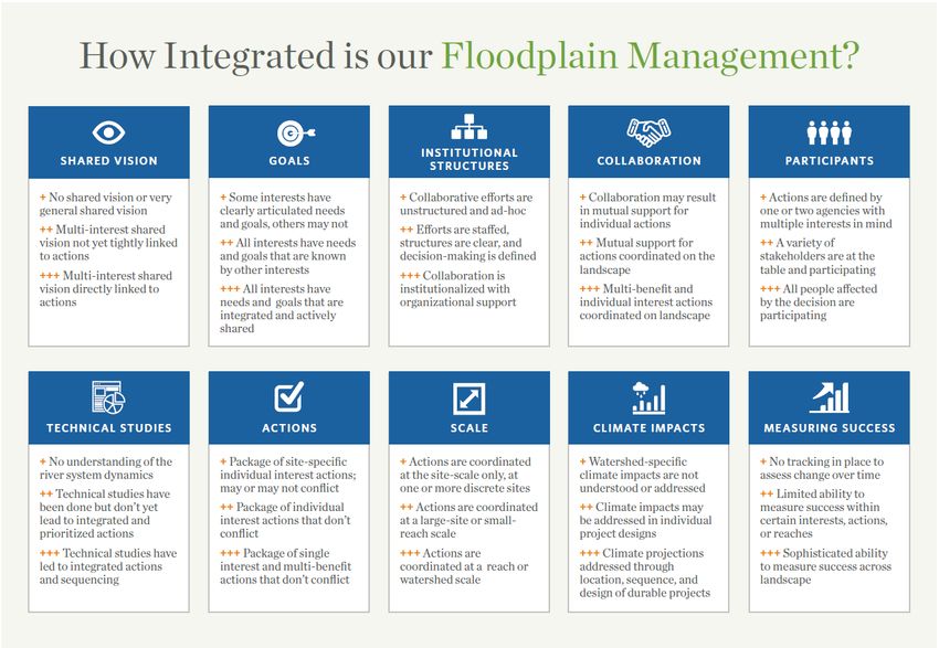
In 2018, the Floodplains by Design team developed an initial draft set of ten elements of
integration that should be considered in integrated floodplain management processes at the local
scale. Not all local areas will be making progress on each element, and various elements will be
at different levels of sophistication and depth at different times. The figure below shows the ten
elements of integration with bullet points characterizing less robust to more robust efforts for
each element. While the bullet points within an element progress from less robust to more robust,
the overall pathway to more holistic and effective floodplain management paradigm can be non-
linear. Increasing robustness in one element may reduce the robustness of another, which can be
a sign of increased overall robustness. For instance, a small group of people can have a very
robust set of goals. As the group expands and includes more interests, the concurrence on the
goals may naturally become less robust in the short term. However, this “regression” in goals is
actually a sign of overall progression of the effort.
The elements of integration are intended to be a tool for local practitioners to identify the next
best step for IFM in their area. It is not intended to be used to “score” the integrated floodplain
management efforts of a local watershed because, as noted above, the assessment of where the
area is in the overall process of integration may be challenging to discern from just assessing the
status within each box.
8*From “Floodplains by Design: Toward a New Paradigm”, June 2018, The Nature Conservancy
Characteristics of FbD Projects
Ideal projects are part of an integrated strategy designed to holistically manage the floodplain
within a watershed or specific reach of a river. The strategy must identify means to reduce flood
risk to affected communities, restore ecological function, support community and environmental
resiliency to future climate impacts, and provide additional community benefits. In areas where
agriculture is a dominant land use, projects must minimize negative impacts to agriculture and
identify strategies to support local agricultural interests. Projects should be part of a watershed
or a reach-strategy that connect rivers with their floodplains, giving floodwater room to spread
out and allowing room for the dynamic processes that form critical habitats to be restored. A
river reach is a user-defined section of river that contains a unifying geomorphic, land-use,
infrastructure or other characteristics. A watershed or reach strategy is generally based on a
technical assessment of the river or reach, and a robust stakeholder process that results in
agreement on objectives and a set of integrated actions. A project on an individual site can in
itself contain all the required benefits for flood risk reduction, ecological function and
community interests, or it can be one or more component(s) of a coherent larger strategy that
9collectively achieve all the benefits. If it is the latter, the project proponent must demonstrate
how the project fits into a larger strategy that has broad support of the affected communities. . It
is important for project sponsors to explain in the long description and other relevant sections
how their project considers either a watershed scale, reach scale, or site scale approach.
Watershed scale projects are not simply a collection of individual projects, but an integrated
combination of projects that work together to achieve the project objectives. It is important to
explain how integration is being achieved and how different project components are connected
or related. Additionally, any Floodplains by Design projects, regardless of scale, are
expected to adhere to a 2 to 3 year timeline.
The focus of the Floodplains by Design program are the major rivers and their estuaries in a
given watershed. Major rivers and estuaries are where the most extensive flood risks exist,
where the greatest ecological restoration opportunities reside, and where much of our best
agricultural soils are located. Projects on large river systems are more likely to receive funding
than projects on small river systems or creeks. The table in appendix G outlines measures for
key outcomes of FbD projects. Grant proposals should explain project outcomes in these terms,
or, if a grant proposal is for feasibility or early design work, project proponents should include
analyses in their application that will provide this information.
Reduce Flood Risk and Damage
Floodplains by Design projects must reduce flood risk to communities or be part of a strategy
that reduces flood risk. A Floodplains by Design project must reduce flood risk on both a short-
term and long-term basis. Many existing flooding problems are anticipated to increase in the near
future due to climate change and development pressures from a growing population. FbD
projects must develop solutions that address existing flood risk and also consider the effects of
projected changes to river flows, sea level rise, sediment delivery and other factors that could
increase flood risk in the future.
One approach to lasting solutions is to move people and infrastructure away from the river,
remove impediments to flow, and provide more floodplain area for floodwater conveyance and
storage. Flood risk reduction measures should not encourage new land development that
increases potential future flood risk. It is important to note that projects that address flooding
due solely to drainage problems do not meet the flood risk reduction intent of FbD, although it
can be part of a larger project. This is discussed further in the agriculture section below.
Floodplains by Design can support redevelopment and improved flood resiliency in historically
established and substantially built-out urban areas. However, to reduce long-term flood risks all
projects should consider whether moving people and infrastructure away from the river and out
10of high-risk areas is feasible. Except in situations where a community has no other options for
meeting appropriate growth targets, projects that induce additional urban development and
impervious surface within floodplains will not score well.
The flood risk reduction component of the FbD project should include a quantified
demonstration of improved flood safety for an area and a demonstration of no adverse impact
(that the project will not worsen flood damage anywhere else). Additionally, flood risk reduction
measures should not create adverse ecological impacts. Feasibility and design projects should
include appropriate analysis of anticipated changes to flood risk in the scope of work so that
these outcomes are understood prior to advancing to the next project phase. Construction project
proposals should be able to quantify flood risk reduction resulting from the proposed actions.
Ecological Restoration and/or Preservation
Floodplains by Design projects must have a significant ecological restoration component or be
part of a watershed or reach strategy that will significantly restore ecological function. The
ecosystem restoration or preservation component of the FbD project should include a quantified
description of restored ecosystem processes and functions, including benefits to salmon. Projects
that clearly address recovery priorities for salmon species that are ESA-listed or are the preferred prey of endangered
Southern Resident Killer Whales will score higher. A higher probability of long-term ecological benefits will be
provided by projects that maintain or re-establish natural processes and functions, taking into account future
conditions.. Where it is not feasible to have the restoration in the same location of a flood risk
reduction action, the restoration can occur in the same reach provided it’s part of an integrated
strategy. Ecological restoration measures should not increase the risk of flood damage to
existing uses in the floodplain. A higher probability of long term ecological benefits will be
provided by projects that maintain or re-establish natural processes and functions. Projects
should also consider the effects of climate change and accommodate future anticipated changes
to river flows, sea level rise, sediment delivery and other factors that affect ecosystem function
and habitat formation (see Climate Change section, below).
Tribal Support and Engagement
Where Floodplains by Design projects are proposed in areas that will affect Tribal lands, Tribal
interests (including Usual and Accustomed areas) and any potential impacts to treaty rights and
treaty secured resources (treaty rights FAQ: http://nwifc.org/about-us/shellfish/treaty-rights-
faq/) these effects to tribes must be considered. Applicants must work to coordinate and seek the
support of local Tribal interests in their region and any actions proposed should not be in conflict
with the local Tribe’s resource (salmon/shellfish) recovery plans or cultural resource concerns.
Additionally, project proponents must consider whether their proposed actions could limit future
floodplain restoration actions or prevent access to Tribal resources necessary to fulfill treaty
11rights. Coordination with Tribes is expected and letters of support from relevant Tribes are
strongly encouraged.
Enhance Agriculture
Where Floodplains by Design projects are proposed in agricultural areas, local agricultural
interests must be engaged in project development as part of the project partnership so that their
needs and concerns are addressed. The needs and priorities of a particular place and community,
and means to address them, will vary by location, but might include improvements to drainage or
irrigation infrastructure, or protection of farmland with easements.
Drainage (and irrigation) infrastructure is an important issue in maintaining agriculture in many
floodplains and is often intertwined with flood control infrastructure. As described in the flood
risk reduction section above, projects that address flooding caused solely by poor drainage are
not considered flood risk reduction projects in the context of FbD. However, projects that
include a drainage (or irrigation) improvement element to benefit agriculture, in addition to a
flood risk reduction component consistent with the FbD intent, can gain points in the agriculture
category.
Cost Effective
Strong FbD projects will also be cost effective. Cost effectiveness is demonstrated by
quantifying the cost of the proposed multi-benefit approach and comparing to the cost of
alternative approach(es) to manage flood risks, restore ecological function and habitat, and
address relevant agricultural needs. This may include anticipated reductions in long-term
infrastructure maintenance and flood damage costs. Project applications should have a clear and
appropriate scope of work and budget, and include the proportion of match that is being provided
and the other fund sources leveraged by the project.
Other Community Needs
Floodplains by Design projects may also include actions to address other community needs that
are compatible with flood risk reduction and ecological restoration, including improved water
quality, increased recreational opportunities, or other needs specific to a particular community.
What these other benefits look like will depend on the needs of a particular community and
actions the community determines are most appropriate to address their needs. Water quality
improvements might include riparian planting, removing impervious surfaces, or reducing non-
point pollution from homes or farms. Increased recreational access might include increased
miles of trail, or additional boat ramps or fishing access points. Project applications that
12demonstrate community engagement and efforts to address other community needs in an
inclusive and equitable manner will be scored higher.
Partnerships
Integrated floodplain projects, by their nature, require that a variety of interests and organizations
coordinate and collaborate to develop projects. Depending on the location, scope and affected
interests of a particular project, proponents will develop partnerships with some or all of the
following groups:
• Flood/Floodplain management authorities
• Ecosystem restoration and salmon recovery entities
(e.g., Lead Entities, Local Integrating Organizations, etc.
• Agricultural interests and organizations
• Tribes
• Community recreation departments and organizations
• Local governments such as cities, towns and counties
• Economic development organizations
• Environmental organizations
• Federal and state natural resources agencies
Because there is a match requirement (see Match section in Chapter 2), all Floodplains by
Design projects are financial partnerships. Past projects have included funding from federal or
state grants such as the Salmon Recovery Funding Board and National Oceanic and Atmospheric
Administration, local flood control districts, counties or cities, and/or United States Army Corps
of Engineers, among other sources.
It is critical that partnerships form early in the project development process. Proponents should
identify the organizations and parties that may have an interest in the project and reach out to
them early and often so that all interests are represented, needs and concerns are heard and
addressed, and the resulting project is supported by all affected parties. There is no boiler plate
list of groups for any project or even particular organizations for a given interest group. It is up
to the local project sponsor to determine the organizations and interests that are relevant to a
particular watershed river reach or project. The application should include a narrative that
describes the outreach that was done and specific involvement of interests related to the project.
Ideally, project applicants will receive the written support of interested organizations and
individuals.
13Climate Change
Floodplains by Design encourages integrated approaches that consider climate impacts on
floodplain systems. Climate change is projected to alter floodplain hydrology, sedimentation and
sea levels throughout Washington State and as such is a significant concern for all aspects of
floodplain management. The extent and frequency of flooding is projected to increase in the
future, resulting in higher flood risks to human communities and further impacts to salmon
populations. Projected low summer flows may cause warmer water temperatures that exceed the
thermal threshold for salmon, and is an important concern for potentially limiting water
availability for farms. Increases in sea levels will increase the risk to coastal areas from storm
surges and inundation, and could impact drainage of coastal agricultural lands. Projected shifts in
temperature and precipitation regimes are likely to compound existing stressors on floodplain
habitats and salmon populations. Strong FbD proposals and project designs should consider the
effects of climate change and address future changes to hydrology, sediment delivery, sea level
rise, and other factors that affect floodplain systems. Strong FbD proposals will:
1. Identify critical impacts of climate change specific to the project area and stakeholder and
Tribal interests. Many regions have completed vulnerability assessments or climate
action plans that identify these key risks. In regions where these plans have not been
completed, projects proponents can use the available regional data to make their best
assessment of key impacts in their watershed.
2. Incorporate projections into project modeling and design plans so that there is confidence
that projects will continue to meet flood and ecosystem goals into the future.
The discussion of climate change impacts on the project area and proposed actions should be
included in the scored sections for Flood Hazard Risk Reduction, Floodplain Ecosystem
Protection and/or Restoration, and Agricultural Benefits. This information will be used to
determine the robustness and durability of proposed actions as related to flood, ecosystem and
agriculture outcomes. Proposals that discuss the specific effects of climate change in the project
or planning area, and describe how this information was used in project selection and design will
result in more points than general regional concepts of climate change. Answers may be brief but
should include:
• Citations of existing research / reports that are relevant to the project area.
• Consideration of impacts observed during historical events that can serve as an analog
for future conditions (e.g., recent large flooding events, warming events/trends, etc.)
• Description of how climate change predictions were incorporated into or used during
project site selection or design.
• Where possible, models/projections of future floodplain or nearshore inundation/risk.
14• Description of confidence in flood, ecosystem and farm outcomes and for how long
into the future.
Grant Program Details
Entities eligible to apply include:
• Counties, cities, and towns
• Special purpose districts, such as flood control districts
• Federally recognized tribes
• Conservation districts
• Municipal or quasi-municipal corporations
• Not-for-profit organizations that are recognized as tax exempt by the Internal Revenue
Service
Note: Ecology will issue a grant to a single eligible recipient that will be responsible for all
Ecology-grant-required actions and will manage all sub-agreements. FbD grant recipients
may provide sub-agreements to other organizations and partners in a watershed where a large
body of work will occur.
Eligible project activities include:
• Pre-construction planning
• Feasibility
• Design
• Permitting
• Construction
• Land Acquisition/Land Conservation/Easement Purchase
• Residential buy-outs and relocation costs
• Project-specific outreach and education components
• Riparian/wetland restoration
• Pre- and post-construction assessment elements
Statutory and administrative requirements
Statutory requirements, administrative rule uses and limitations, and program and agency policy
provide the framework for the Funding Guidelines. Key statutes, rules, and policies include:
• Administrative Requirements for Recipients of Ecology Grants and Loans Managed in
EAGL; see https://fortress.wa.gov/ecy/publications/SummaryPages/1701004.html
• Environmental justice policy; See
http://teams/sites/EXEC/policies/PolicyDocuments/POL01-12.pdf
15• Washington State Department of Archaeology and Historic Preservation; see:
https://www.dahp.wa.gov
• Guidelines and Specifications for Preparing Quality Assurance Project Plans for
Environmental Studies; see:
https://fortress.wa.gov/ecy/publications/publications/0403030.pdf. A QAPP template is
available at www.ecy.wa.gov/programs/eap/qa/docs/QAPPtool/index.html.
Ecology’s General Terms and Conditions are nonnegotiable and failure to accept these
conditions, or any attempt to alter these conditions can result in revocation of grant awards
Applicability of the Floodplain by Design Funding Guidelines
The Floodplains by Design program is strives for continual improvement. As such, funding
guidelines and other aspects of the program will be routinely updated. These funding guidelines
apply to all Floodplain by Design grants awarded after the date of publication, and supersede any
previous publications of the guidelines. They will be applied to all grant agreements completed
and signed after publication, until superseded by a new publication of the guidelines. Certain
elements of the guidelines may need to be incorporated into the Special Terms and Conditions of
the grant agreements, as determined by the Floodplains by Design Grant program.
16Chapter 2: Funding Program Details
This chapter provides a basic overview of the funding program, including applicant and project
eligibility and funding provisions. More specific information about project eligibility may be
found in Chapters 3 and 4.
Ecology manages the Floodplains by Design program funding under a biennial funding cycle.
Proposals are due in even-numbered years. Funds, if appropriated by the state legislature, are
available starting in the odd-numbered year. Ecology reviews, rates, and ranks applications and
then distributes funds to the highest priority grant projects.
Funding levels
Total funds available for Floodplains by Design have varied. The amount of funding available on
a competitive basis for each State biennium is based on legislative directives. Ecology does not
know the exact amount of funding available at the time a particular funding cycle begins. The
amount of funding will not be known until state appropriations are made. Table 1 shows past
funding availability.
Table 1: Funding Appropriated by Washington State Legislature
Range of
Funding
Fiscal Year funding
Appropriated
awarded
$50,000 to
FY 2013 Competitive Grants $11,000,000
$2,000,000
$867,000 to
FY 2013 Proviso Grants $33,000,000
$7,881,000
$560,000 to
2015-2017 Competitive Grants $35,560,000
$9.501,000
$415,000 to
2017-2019 Competitive Grants $35,388,073
$7.750,000
$516,000 to
2019-2021 Competitive Grants $50.400,000
$9.402,000
Fund Request Limit
The Floodplains by Design grant program does not have a hard limit on the amount of funding
requested. We encourage project sponsors to think holistically and in terms of complete
solutions when putting projects together. However, in light of total funding and the significant
17needs that exist across the state, Ecology has yet to fund more than $9.5 million in any one FbD
grant. Note that the total project cost may be well in excess of this amount, when required
match, other funding sources and multiple project phases are included. If a project is submitted
that enters into the higher levels of FbD-fund request, Ecology may ask the sponsor to consider
phasing the project over time, reducing the scope of work, consider partnering with other
available fund sources (e.g. local flood control district) or otherwise reducing their fund request.
Grant Match Requirements
Projects must demonstrate a 20% match (i.e., Flood Control Zone District, city, county, or
federal funds). The program offers extensive flexibility in terms of what constitutes match.
Match can be shown in the form of other grant funds, value of land previously acquired as long
as the land is used for implementation of the project, time spent working on a project, and in-
kind materials. Communities that meet the definition of Economically Distressed Communities
as defined in Appendix F of the Funding Guidelines will have their match requirement waived.
Please contact Ecology staff if you believe your community would qualify for this waiver.
Land Purchase as Match
Land acquisition is commonly a necessary step in completing an overall project. This process is
inherently opportunity based – it must have both an interested seller and funds available. Land
acquisition over a period of time is an integral part of many FbD projects. The grant program
recognizes the need for flexibility related to the timing of land acquisition that is use as match.
In select cases, the Floodplains by Design Grant Program can assist a local jurisdiction in
meeting its match requirements by offering the following exception to the standard match
approach:
1. “Historical Acquisition” may be used as match as long as acquisition has been within
the last ten years; has a direct relation to the current project; is able to provide a
completed “Acquisition Report” to determine appraised value; and funded by a
source other than Ecology; and
2. Valuation will be based on the original purchase value, or the current value, as
supported by a recent appraisal, at the project sponsors discretion. The land must
have been purchased within the last 10 years for the purpose of future flood risk
reduction, habitat improvement, public open space, or other use consistent with the
proposed project. If the property was purchased in the last 10 years and the purchase
was supported by an appraisal, the purchase price of land that is necessary and
reasonable to complete the project may be used as match.
Note: The land value used as match cannot have been previously used as match for
another grant.
18Cash match
Cash match includes any eligible project costs paid for directly by the recipient that are not
reimbursed by the Ecology grant or another third party. Donations that become the long-term
property of the recipient will be considered for cash match purposes. (See Administration
Requirements for Recipients of Ecology Grants and Loans (Yellow Book), page 37:
https://fortress.wa.gov/ecy/publications/SummaryPages/1701004.html.
Grants used to match other grants
If a recipient wants to use a grant from another funding agency as match, the recipient should
check with the funding agency issuing the grant to ensure that it can be used as match for an
Ecology grant. The following applies when using other grants to match an Ecology grant.
• The scope of work on the matching grant must directly satisfy the portion of the scope of
work on the Ecology grant where the work is contributed.
• The date that the costs for the matching grant are incurred must fall before the expiration
dates of the Ecology grant.
• The costs incurred under the matching grant must be eligible according to all criteria for
the Ecology grant.
• The matching grant cannot originate from the same funding source as the Ecology grant.
• Funds, goods, or services cannot be used as match more than once.
In-kind match
In-Kind match is a donated or volunteer service, goods, or property contributed by a third party
without direct monetary compensation. Other in-kind match includes donated or loaned real or
personal property, volunteer services, and employee services donated to a project. In-kind
match does not include eligible project costs paid directly by the recipient such as paid staff
services, considered a cash expenditure by Ecology (see Cash Match above). In-kind
contributions must be fully documented and reported separately when requesting reimbursement.
For adults, the in-kind rate is $15.00 per hour. For persons under the age of 18, the rate is the
Washington State minimum wage at the time the service is provided. The current in-kind rate
for volunteer services includes the value of travel expenses contributed by volunteers. For
additional explanation of in-kind match see page 37 of this document;
https://fortress.wa.gov/ecy/publications/SummaryPages/1701004.html
19Third-party in-kind contribution
When a third-party employer (not the recipient, sub-recipient, state agency, or a contractor under
the agreement) contributes the services of an employee, in the employee’s normal line of work,
to the project at no charge to the recipient, the services may be valued at the employee’s regular
rate of pay.
Ineligible Contributions
The following are examples of ineligible in-kind contributions:
• Contributions of overhead costs, per-diem, travel, and subsistence expenses.
• Contributed time from individuals receiving compensation through the grant, except
when those individuals are off duty and contributing on their own time.
• Time spent at advisory groups or meetings that do not directly relate to the project
• Studies conducted by other state or federal agencies.
20Chapter 3: Eligible Project Types and Activities
Pre-Construction
Costs of preparing pre-construction documents, including reach studies and other area-specific
assessments of floodplain conditions and needs; engineering reports; environmental review; and
related work that lead to the identification of capital projects may be eligible for Floodplains by
Design Program funding. Potential applicants are encouraged to check with your Regional FbD
contact to ensure that your pre-construction project scope will be eligible.
Feasibility and Design
Floodplains by Design funds are allowable for both feasibility studies and design projects.
Design project deliverables must be completed by an engineer licensed in the State of
Washington. As a minimum deliverable preliminary designs of at least a 30% stage must be
submitted by the completion of the grant agreement.
The recipient of a feasibility and/or design project must submit preliminary designs / design
report to Ecology’s project manager prior to the final designs to ensure there are no adverse
impacts to future restoration in priority habitats.
Construction
The recipient of a construction grant must ensure that the project complies with the approved
(signed and sealed) plans and specifications prepared by an engineer licensed in the State of
Washington. Competent and adequate construction management and inspections are required.
Projects that contain construction-only elements must be ready to start construction upon
receipt of funding by FbD. That means acquisitions, design, permitting, etc. must be complete
prior to award. A project that includes all elements, including acquisition, design, permitting and
construction must present a schedule that completes the project in 2-3 years from funding award.
The project may need to be “phased” into discrete, timely actions if construction would not occur
for several years. In that case the pre-cursor activities e.g. design would be funded in one round,
with construction applying for funding in a future round.
Design and construction combined
Applicants can apply for a combined design and construction project. All the applicable
requirements for both design and construction projects apply. See the note in the construction
21discussion above on combining all elements of a project and the need to maintain a 2-3 year
completion date.
Land purchase
Where purchase of land and/or easements is necessary for an FbD project, land purchase is an
eligible project cost. This includes purchase of conservation easements, development rights or
fee title to land. Where the purchase of an entire parcel is necessary to obtain the required land,
the proposal should be clear regarding management of the land obtained outside the project area.
This land must be managed consistent with FbD objectives, and should avoid creating new
residential or commercial-type development in flood-prone areas. Additionally, Floodplains by
Design funds can be applied/used for a comprehensive river reach-based approach to land
acquisition should multiple river front parcels become available.
Ecology can work through an escrow process, if needed, to assist the recipient in the land
acquisition process.
Please note: Ecology will not be a holder or co-holder of conservation easements under the
Floodplains by Design Grant Program.
Land Purchase Usage and Restrictions: Eligible land costs are subject to the following
limitations, in addition to other requirements of the agency:
• Public Access – Appropriate opportunities for public access must be provided to land
acquired with FbD funds where feasible, unless an exception is granted. If a recipient
proposes to preclude public access from grant-acquired property, justification must be
provided relating to public safety or other relevant features of the property and adjoining
area
Please Note: Public access will not be required for the purchase of Conservation
Easements.
• State Agency Land Acquisition Prohibited – State agencies are ineligible to receive
FbD funds.
• Willing Seller Only – FbD land acquisitions are by willing sellers only. Acquiring land
by condemnation or eminent domain are not eligible for FbD grant reimbursement.
• If Relocation Needed – Floodplains by Design will cover costs associated with
relocation if needed. FbD recognizes that many entities and local governments follow the
Federal Uniform Relocation Act (URA) and will work with local governments
accordingly.
https://portal.hud.gov/hudportal/HUD?src=/program_offices/comm_planning/affordableh
ousing/training/web/relocation/overview
22When a land acquisition project is awarded funding; the recipient is required to provide the
following documentation prior to closing:
a. Appraisal
b. Name/Address of seller
c. General Vicinity Map
d. Site Specific Map
e. Legal Description
f. Title Report
g. Settlement Statement
h. Good Faith Clean Site Survey1 signed by the appropriate jurisdiction.
i. Photographic documentation, with labels, of each property before acquisition in sufficient
quantity / quality to effectively illustrate the acquisition. (Note: “after” photos will be
needed if site is subsequently cleared of human elements, structures, fencing, etc.)
j. Recorded deed with restrictions. Land acquired under this agreement will carry a deed
restriction in perpetuity. The purpose is to prevent future development on land acquired
and to ensure that its primary use will be protection of floodplains, wetlands, open-
space, etc. Depending on the nature of the parcel, the deed will carry one of the
following restrictions:
o Deed restriction for floodplain / wetland protection only with no public access
(for example: riverine access to a restored floodplain); or
o Deed restriction allowing for limited public access (for example: a setback levee
with trails, parking, restroom facilities, and access for levee maintenance,
agriculture, or grazing).
Project specific outreach and education components
Projects that require targeted project specific public outreach and education efforts are eligible
for grant funding, as part of the larger project. Project specific outreach and education use
effective methods and programs, to engage the public's interest in flood reduction and ecosystem
restoration. Applicants should consider that the public has different levels of background
knowledge of flooding and ecological restoration issues. Therefore, applicants should consider a
multi-pronged approach to project outreach. Project outreach efforts should include:
• Targeting only audiences affected or impacted by the proposed project
• Generating basic awareness of flooding and ecosystems for target audience.
• Educating at a more sophisticated level using comprehensive content.
23Removal of the Small Projects category (Chapter 3)
We have removed the language and process around evaluating small projects. All projects,
regardless of scope and funding request, will be evaluated using the same process and criteria.
When a smaller scope or funding request is evaluated it will be given equal weight with larger,
more expensive projects, if the proposal completely addressed the local need and/or performs the
feasibility, stakeholder outreach, and other actions needed to develop a more complete project.
Bigger is not always better, and the ability of the proposal to fulfill the needs of the stakeholders
in the affected area is the more important factor.
Riparian/wetland restoration, planting
Planning and implementing riparian and wetland habitat restoration projects are eligible grant
components. If the project includes planting, you must provide a planting plan or description of
how you will ensure plant survival and maintenance. More details are provided in Chapter 4.
Pre and Post project assessment
Project assessment both before and after project completion is important for tracking project
results. Ecology may allow the use of grant funds for project assessments if the assessment takes
place within the grant period. Typically, a recipient undertakes pre and post project assessments
to characterize, identify or quantify the existing conditions present at/on a particular site/area.
Prior to initiating environmental assessment activities, the recipient must prepare a Quality
Assurance Project Plan (QAPP); for more information, please review the QAPP discussion in
Chapter 5, under Agreement Conditions.
Other Administrative costs
In addition to the project types above, a Floodplains by Design grant routinely covers costs for
other administrative items such as grant management, obtaining required permits and approvals,
completing Letters of Map Revisions or Conditional Letters of Map Revision (as required by 44
CFR 65.3), and other administrative requirements.
Ineligible Project Types
Remediation Projects
Floodplains by Design funds cannot be used for projects whose primary focus is remediation of
toxic sediments or structures. Project proponents can receive guidance and are encouraged to
work with the Department of Ecology’s Toxic Cleanup Program (TCP) to address toxics on site
24prior to any application for Floodplains by Design funding. For more information on cleanup of
contaminated sites, visit https://ecology.wa.gov/Spills-Cleanup/Contamination-cleanup
Transfer of Development Rights (TDR) and Purchase of Development
Rights (PDR) Programs
It has been established that Floodplains by Design funds cannot be used in TDR programs, but
can be used in PDR Programs. In 2016, the Floodplains by Design Program sought WA State
Treasury’s input on the use of said funds in TDR and PDR programs. Treasury concluded that as
FbD funds are public tax exempt and bonded funds, they are not appropriate for the TDR
programs due to the potential of private gain with this public funding source. The Purchase of
Development Rights (PDR) is acceptable and is an important tool in the FbD system. Grant
recipients should carefully consider if they want to use PDRs later in a TDR program before they
utilize FbD funding.
Changes in Project Scope after Funding Award
Any project recipient that significantly deviates from their original scope after award of funding
may have their grant award reduced or re-scoped, at Ecology’s discretion after discussion with
the grant recipient. In order for a re-scoping to be eligible, it must be consistent with the over-
arching strategy and elements described in the proposal that was evaluated during the scoring
and ranking process. New scope elements that were not reviewed as part of the original proposal
cannot be funded in the applicable round. Or, Ecology may decide to reprogram the entire award
to another jurisdiction based on the nature of the scope change and whether the project still meets
the original intent.
Any discussion of a proposed re-scoping effort must include consideration of the impact on
invested stakeholders, including but not limited to; the local community, governmental agencies
and tribes, elected officials, other funding agencies and sources that have invested in the project,
agricultural interests, salmon recovery and ecosystem restoration interests, and floodplain
management and emergency planning agencies and interests. The grant recipient proposing the
changes in scope must provide assurances that the stakeholders are still in support of the
changes.
25Chapter 4: Applying for Funding
The Funding Cycle
The application cycle for the 2021-2023 Biennium begins on November 4, 2019 when the
Request for Proposals (RFP) is released. The deadline for submittal of pre-applications is
January 31, 2020. Other important funding cycle dates for the current Biennium will be outlined
on the Floodplains by Design grant webpage. The application process begins with brief Pre-
Proposals submitted, then top applicants are invited to submit full Proposals through our online
EAGL system, where they are evaluated and scored, and finally a ranked list is developed and
submitted to the Governor’s Office of Financial Management and the State Legislature for
consideration during the funding appropriation process. The amount of funding available varies;
it is determined biennially by the state Legislature.
1) Pre-Proposals
A Request for Proposals (RFP) is released in the fall of odd numbered years, with a Pre-
application form provided by Ecology. Applicants will prepare a brief Pre-application,
describing the project scope and how the project advances both flood hazard reduction and
floodplain ecosystem protection or restoration. Support (existing or in process) from floodplain
stakeholders should be described, including the stakeholder groups identified, the nature of the
interaction (e.g. advisory group, one-time contact with landowners, workshops, etc.) and any
other process information around stakeholder engagement. The pre-proposal must indicate that at
least the Lead Entity or the Local Integrating Organization (LIO) in applicable Puget Sound
watersheds, and lead flood hazard authority have been contacted and that they are in support of
the project.
The pre-application must include a discussion of how the project is consistent with local flood
hazard plans, salmon recovery or habitat restoration plans, LIO ecosystem recovery plans (Puget
Sound only), agricultural plans and related planning instruments. The pre-application form will
provide a template that requires identification of the planning process, the entities involved, a
reference to the appropriate plan, and how the project meets priorities set by those plans. The
pre-application should describe other benefits of the project beyond flood risk reduction, such as
agricultural benefits, salmon recovery, water quality improvements, or enhanced recreation, and
should describe the integration and collaboration efforts that led to this proposal. The pre-
application should also delineate a project schedule and deliverables. In addition, the pre-
application must provide a preliminary budget for the project and the amount and source of
match. Pre-applications will be submitted in PDF form to Ecology, then evaluated by Ecology
26flood team staff and the FbD Management Team, and the top pre-applications best meeting the
objectives of the FbD program will be invited to submit full proposals.
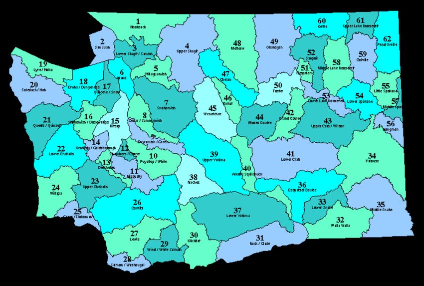
One application encouraged for watersheds and sub-watersheds.
In order to promote Integrated Floodplain Management and coordination of all stakeholders,
applicants are encouraged to submit a single, full application for activities within a watershed
(defined for these purposes as a WRIA). During the pre-proposal evaluation process Ecology
will flag multiple submittals from the same watershed (WRIA) or sub-watershed area, and
encourage the sponsors to discuss their proposals with each other if they have not already done
so. We recognize that this is not always feasible, and we are not limiting the number of
applications in a given area, but want to encourage coordinated planning and solutions.
Evidence of discussions between project sponsors for more than one project in a watershed is an
indicator of the level of integration and cooperation occurring in a watershed and may increase
scores in the integration section of the full application.
For this purpose, watersheds are defined in Appendix B, also known as Water Resource
Inventory Areas (WRIAs).
2) Full Proposals
Full proposals will be submitted via Ecology’s EAGL (Ecology Administration of Grants and
Loans) in the spring of even numbered years. To access the system, applicants must first:
1. Register for a Secure Access Washington (SAW) online services account.
2. Register as an EAGL User.
To register for a SAW account, visit http://secureaccess.wa.gov/ in order to access the EAGL
system. SAW accounts may take some time to set up, so starting early is encouraged. Each staff
member of an organization that will have a role in the project (e.g., project manager, financial
manager, and grant signatory) must each establish their own separate SAW account before you can
apply. You may not share a SAW account with another person or organization.
3) Evaluation Panel
Ecology uses a team of technical experts to evaluate and score full project proposals based on
responses provided on the application and then develops the final list with the Floodplains by
Design Management Team based on other program policies and priorities. The Flood
Hazard/Risk Reduction, Floodplain ecosystem protection or restoration and Collaboration and
Integration t categories have 60 points available each, which reflects the importance of those
three categories. Agricultural benefits also has a separate category due to its importance in many
floodplain areas as there is a need to understand the potential impacts and benefits to any
27proposed actions agricultural areas. For a more complete description of the scoring guidance see
Appendix C.
Scoring of the full proposals will be conducted by a Technical Review Team, comprised of
experts in the fields of floodplain management, natural hazards mitigation, salmon recovery,
ecosystem restoration, agricultural practices, and general project management. Ecology will
assemble the review teams in advance of the full application deadline. The full application
review team will be informed by Ecology staff and others who were able to attend the
presentations given by the project sponsors in spring of 2020 (the full review process is available
at Ecology’s Floodplains by Design web page). The reviewers will consider the entire
application as a whole, share their critiques, comments and scores with their fellow review team
members. After consultation with each other the review team will agree upon a single final score
for the proposal/project.
The Technical Review Teams’ members will be drawn from state and federal agencies, as well
as nonprofit organizations who have not submitted applications for FbD funds. If a proposal
impacts agricultural lands, Ecology will seek input from Conservation District or other
agricultural group representatives knowledgeable about your geographic areas. If a proposal
impacts salmon, Ecology will seek input from Lead Entities or other salmon-related groups
knowledgeable about your geographic area.
Once the full proposals are scored, they will be ranked in score order and provided to the
Floodplains by Design Management Team. . Final scores are not the only consideration used in
proposing projects for funding. The scoring system is intended to identify high-quality projects
that meet the FbD program intent of integrated floodplain management at a watershed or river-
reach scale that considers flood hazard reduction, ecological preservation and restoration, salmon
recovery, agricultural benefits, and other community benefits. Other considerations in creating
the proposed funding list in addition to project scoring include:
• Providing grant funding to a balance of project activities (such as construction vs. pre-
construction), and types
• Ensuring geographic diversity in FbD investments across the state.
• Past performance (demonstrated ability to complete projects within 2-3 years) on
Floodplains by Design grants
• The level of FbD funding already awarded that is unspent at the time of grant ranking
• Consideration of social and economic equity issues
A full proposal funding list will be released in early November 2020. All full proposal
applicants will be notified at that time of their project status.
28The final list for full proposal funding will be submitted to the Governor’s Office as part of
Ecology’s budget request for the 2021-23 biennium. The Governor will release a budget in
December 2020 for consideration by the legislature. The state legislature will adopt the final
funding level for FbD in the state budget. If the funding level is less than requested, Ecology
may need to work with the FbD partnership to refine the final funding list to ensure program
objectives are met. If an applicant makes significant changes to the scope of work after the
application deadline, Ecology may withdraw its funding offer.
Elements of Successful Proposals
In general, a successful FbD project proposal will:
• Show how the project solves or addresses a significant flooding problem and advances a
priority salmon recovery need.
• Demonstrate an integrated floodplain management approach, particularly at a reach or
watershed scale
• Describe how relevant authorities, tribes, and stakeholders have collaborated to develop
the proposal and describe the institutional structures in place to support ongoing
collaboration
• Demonstrate a clear connection between the proposed project and how it will help
resolve the identified flooding issue.
• Document that the proposal will not worsen flooding in another location.
• Show how the project will not induce more development in the floodplain, and as
possible reduce existing development in the floodplain.
• Demonstrate how the project takes climate change impacts into account and enhances
long-term community and environmental resilience.
• For Puget Sound projects, show how the project is consistent with the Puget Sound
Partnership Action Agenda and applicable LIO ecosystem recovery plans.
29Complete a table of project outcomes measurements.
• For on-the-ground activities such as construction or acquisition, complete the FbD
metrics table (see appendix G) to document anticipated project outcomes. This metrics
table is required, but will not be scored.
• Include information about project activities that are to be done as part of the 2021-23
funding cycle. For purposes of metrics data collection, we are not including project
progress prior to the 2021-23 funding cycle, or anticipated progress after the 2021-23
funding cycle.
• For each metric, the application should briefly describe the methodology utilized to
measure the metric in the Methodology Used section. For each category, the most precise
data source available should be used.
• Several of the metrics ask for a GIS polygon. This information is extremely important.
This spatial data allows the FbD program to analyze the aggregate benefits of the
program.
• Applications without a completed metrics table will be considered incomplete.
Describe the community support and stakeholder involvement that shaped the project.
• Document the outreach and engagement conducted to develop the proposal.
• Document support for the project from affected parties.
• Provide documentation of plan(s) that supports the project.
• Explain why the project is a high priority for the affected community(ies)
• If your project impacts local flooding and flood control structures, document a robust
stakeholder process that involves the local Floodplain Managers in your region.
• If your project impacts agricultural land, document a robust stakeholder process that
involves the agricultural community including, but not limited to, letters of support from
landowners in the project area.
• If your project impacts salmon habitat, document a robust stakeholder process that
involves Lead Entities in your region/watershed.
Show that funds will be spent efficiently.
• Provide an accurate, detailed and reasonable budget.
• Show that the funds can be spent in a timely manner (ideally 1 biennium, or 2 years. 3
years if needed.
• Show that the funding request is reasonable compared to the proposed benefit.
Illustrate that the project is ready to proceed.
• Include a well-defined scope of work that has goals, objectives, timelines, and
measurable outcomes.
30You can also read