Geodiversity Strategy 2017 21 - Including the Greater Lincolnshire Geodiversity Action Plan - Greater Lincolnshire Nature ...
←
→
Page content transcription
If your browser does not render page correctly, please read the page content below
Geodiversity Strategy
      2017 - 21

Including the Greater Lincolnshire Geodiversity Action Plan
           i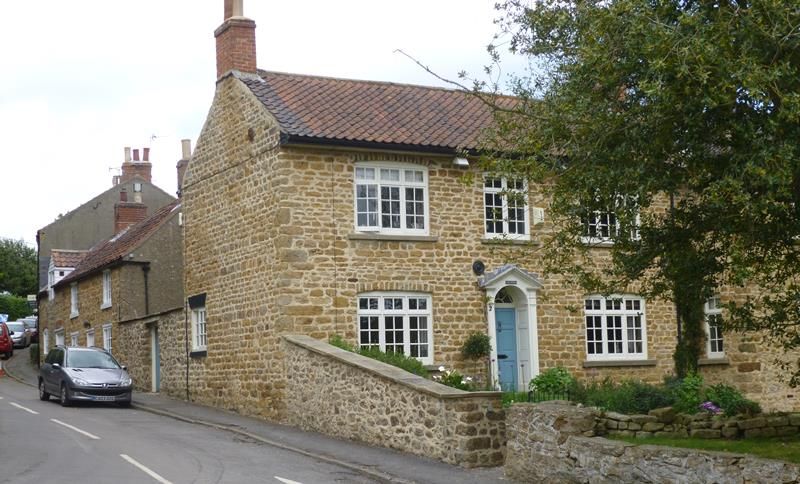
Contents

Foreword ................................................................................................................................... iv
Acknowledgements .................................................................................................................... v
1. Vision and aims .......................................................................................................................1
   1.1 Vision statement.............................................................................................................. 1
   1.2 Aims ................................................................................................................................. 1
2. The role of the Geodiversity Strategy.....................................................................................1
   2.1 The Geodiversity Strategy in context .............................................................................. 2
       Figure 1: The LBP to GLNP ..................................................................................................2
   2.2 Why is geodiversity important? ...................................................................................... 2
       Figure 2: What is geodiversity? ..........................................................................................2
       2.2.1 Ecosystem services ....................................................................................................3
3. Challenges for geodiversity ....................................................................................................5
   3.1 Losses through development .......................................................................................... 5
   3.2 Lack of management ....................................................................................................... 5
   3.3 Other threats ................................................................................................................... 5
4. Geodiversity protection ..........................................................................................................5
   4.1 The protected sites system.............................................................................................. 6
       Figure 3: Hierarchy of protected sites ................................................................................6
   4.2 Legislation and policy outside protected areas ............................................................... 7
       4.2.1 National Planning Policy Framework .........................................................................7
       4.2.2 Geoparks....................................................................................................................7
   4.3 Power to the people ........................................................................................................ 7
5. Of the rocks and landforms ....................................................................................................8
   5.1 The Triassic Period (252 - 201 Mya) ................................................................................ 8
       5.1.1 Influence on the landscape .......................................................................................8
       5.1.2 Economic uses ...........................................................................................................9
       5.1.3 Conservation..............................................................................................................9
   5.2 The Jurassic Period (201 - 145 Mya) ................................................................................ 9
       5.2.1 Influence on the landscape .......................................................................................9
       Figure 4: Generalised Jurassic succession ....................................................................... 10
       5.2.2 Economic uses ........................................................................................................ 11
       Figure 5: Block diagram of the Scunthorpe area showing the Frodingham Ironstone
       workings. ......................................................................................................................... 11
       5.2.3 Conservation........................................................................................................... 12
   5.3 The Cretaceous Period (145 - 66 Mya) .......................................................................... 13

                                                                       i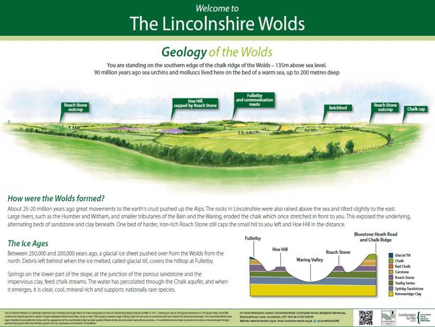
5.3.1 The Lower Cretaceous strata .................................................................................. 13
      Figure 6: The Lower Cretaceous strata ............................................................................ 13
      Figure 7: Diagrammatic section showing relationships of the subdivisions of the Lower
      Cretaceous rocks ............................................................................................................. 14
      5.3.2 Upper Cretaceous ................................................................................................... 14
      5.3.3 Influence on the landscape .................................................................................... 15
      5.3.4 Economic uses ........................................................................................................ 16
      5.3.5 Conservation........................................................................................................... 17
   5.4 Quaternary Period (2.6 Mya - Present) ......................................................................... 17
      5.4.1 Glacial Till ................................................................................................................ 19
      5.4.2 Fluvioglacial Gravels and Sands .............................................................................. 21
      5.4.3 Fluvial Gravels and Sands ....................................................................................... 21
      5.4.4 Coversands ............................................................................................................. 22
      5.4.5 Head........................................................................................................................ 23
      5.4.6 Peat ......................................................................................................................... 24
      5.4.7 Silts ......................................................................................................................... 25
      5.4.8 Alluvium .................................................................................................................. 25
6. Planning and taking action for geodiversity ........................................................................ 27
   6.1 The UK GAP context for Local GAPs .............................................................................. 27
      6.1.2 Criteria for developing action plans ....................................................................... 27
      6.1.3 Plan structure ......................................................................................................... 27
      6.1.4 The role of local groups .......................................................................................... 28
      6.1.5 Monitoring and reporting ....................................................................................... 28
   6.2 GAP progress 2010-2015 ............................................................................................... 28
      Figure 8: Status of GAP 1st edition targets....................................................................... 28
   7. Geodiversity conservation ............................................................................................... 29
   7.1 Current status in Greater Lincolnshire .......................................................................... 29
   7.2 Threats in Greater Lincolnshire ..................................................................................... 29
   7.3 Aim................................................................................................................................. 30
   7.4 Targets and actions 2017-2021 ..................................................................................... 30
8. Geodiversity in policies and plans ....................................................................................... 32
   8.1 Current status in Greater Lincolnshire .......................................................................... 32
   8.2 Threats in Greater Lincolnshire ..................................................................................... 32
   8.3 Aim................................................................................................................................. 32
   8.4 Targets and actions 2017-2021 ..................................................................................... 32
9. Raising geodiversity awareness ........................................................................................... 35
   9.1 Current status in Greater Lincolnshire .......................................................................... 35
   9.2 Threats in Greater Lincolnshire ..................................................................................... 35

                                                                     ii
9.3 Aim................................................................................................................................. 35
9.4 Targets and actions 2017-2021 ..................................................................................... 35
10. Geodiversity organisation and funding ............................................................................. 38
10.1 Current status in Greater Lincolnshire ........................................................................ 38
10.2 Threats in Greater Lincolnshire ................................................................................... 38
10.3 Aim............................................................................................................................... 38
10.4 Targets and actions 2017-2021 ................................................................................... 38
11. Glossary of terms ............................................................................................................... 40
12. References ......................................................................................................................... 45
Appendix 1: List of SSSIs .......................................................................................................... 47
**A glossary can be found at the back of the Strategy from page 40**
Greater Lincolnshire Geodiversity Strategy
c/o Greater Lincolnshire Nature Partnership
Banovallum House
Manor House Street
Horncastle
Lincolnshire
LN9 5HF
01507 528398
info@glnp.org.uk
www.glnp.org.uk/partnership/geodiversity
December 2016
Greater Lincolnshire Geodiversity Group
Edited by Fran Smith
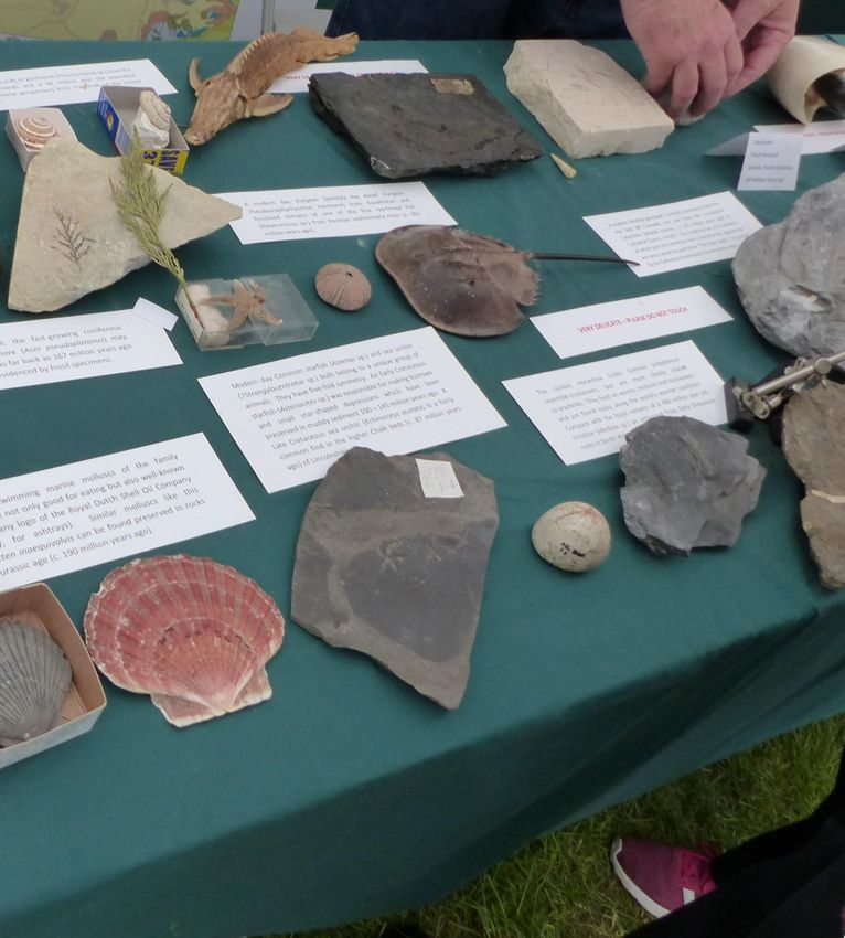
Cover image: Plant and animal fossils at the Lincolnshire Show 2016, © Lincolnshire Wildlife Trust
iii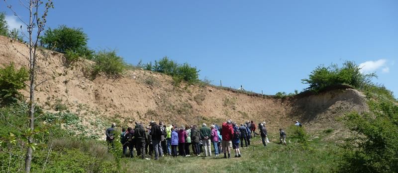
Foreword

This Strategy highlights the importance of geodiversity, not just for itself but in all our daily
lives. It also demonstrates how awareness of geodiversity is increasing. While this Strategy
builds on the work of the previous Geodiversity Action Plan it represents a new phase in
which geodiversity’s relationship with biodiversity and its place within other plans and
policies will receive greater recognition.

However, there is still much to do. Many threats remain and, with resources severely
limited, there are previous actions to be completed. Yet there is good news; there is now a
national Geodiversity Action Plan and a Geodiversity Charter and these are listed in the
Strategy’s action section so that delivery in Greater Lincolnshire will be clearly linked to
national objectives.

Challenges lie ahead, but this Strategy provides clarity and direction, and demonstrates a
desire to improve the state of Greater Lincolnshire’s geodiversity. Much has already been
achieved and with the strong partnership approach of the GLNP and the dedication of all of
those who have written this strategy much more will be achieved by 2021.

Richard Chadd
Chair of the Greater Lincolnshire Nature Partnership

                                                iv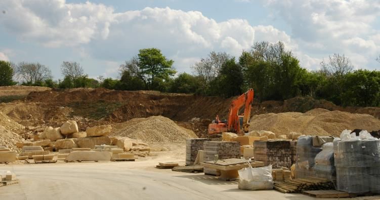
Acknowledgements
                     The Greater Lincolnshire Nature Partnership is grateful to the representatives and
                     volunteers that contributed to writing the Geodiversity Strategy.

                     Working Group members:

                     Malcolm Fry
                     Helen Gamble
                     Paul Hildreth
                     Sarah Smith
                     Jon Watson

                     Tim Langdale-Smith and John Aram must also be acknowledged for all their work on the
                     original geodiversity audit that has been edited and included in this Strategy.

                                                               ********

                     Thanks also go to contributors of the 1st edition of the Lincolnshire GAP. Highlights can be
                     found in GLNP annual reports: www.glnp.org.uk/our-publications/governance

                                                               ********

A Lincolnshire Limestone quarry © John Aram

                                                                    v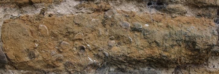
1. Vision and aims
1.1 Vision statement
That Greater Lincolnshire’s geodiversity assets are conserved, recorded, promoted,
understood and enjoyed by all.
1.2 Aims
By working in partnership towards this vision, identifying priorities for action, and engaging
with local stakeholders the Geodiversity Strategy aims to:
Record and conserve the geodiversity of Greater Lincolnshire
Ensure geodiversity is included in relevant plans and policies
Raise awareness of the importance of geodiversity across all sectors
Ensure delivery of geodiversity objectives through adequate funding
1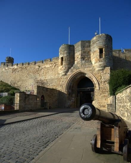
2. The role of the Geodiversity Strategy

2.1 The Geodiversity Strategy in context
This Strategy is an all-in-one document encompassing            Figure 1: The LBP to GLNP
both a Local Geodiversity Action Plan (GAP) and a               The Lincolnshire GAP and the
geodiversity audit. This ensures that all the crucial           Geodiversity Group are an integral
information on Greater Lincolnshire’s geodiversity is in        part of the Greater Lincolnshire
one place. A geodiversity audit presents a summary of           Nature Partnership (GLNP) -
the geodiversity resources of an area, highlighting areas       previously known as the Lincolnshire
of importance and also areas of concern. The aim of a           Biodiversity Partnership (LBP). The
GAP is to raise awareness of geodiversity and through the       LBP covered four work streams: the
identification of local priorities enable delivery of           Biodiversity Action Plan (BAP); the
national targets at a local level. Local GAPs contribute to     Lincolnshire Environmental Records
the delivery of the UK GAP. Together an audit and a GAP         Centre (LERC); Local Sites and
create a coherent whole for geodiversity knowledge and          Geodiversity. LBP was the first
action.                                                         partnership in the UK to be
                                                                structured in this way. The GLNP is
The Lincolnshire GAP 2010-2015 has been delivered               continuing to deliver in these four
through a partnership. This has proven to be a successful       work areas but also has strategic
way to focus resources and share best practice and over         priorities in other key areas. For
time the form of these partnerships has changed (see            more information see:
Figure 1). The Geodiversity Strategy will continue to be        www.glnp.org.uk
delivered through this successful partnership method.

Through this collaborative partnership approach and the
dedication of many individuals much has been delivered.
Yet there is still much to do. Many topics within the 1st
edition of the Lincolnshire GAP remain aspirational. This
Strategy seeks to refocus efforts in order to design more
successful initiatives in the future and learn from those
areas that have been delivered to ensure this knowledge
can be shared.

2.2 Why is geodiversity important?
Geodiversity is profoundly more important than most people realise. The rocks underneath
us form the soils in which food is grown; they provide the clay to make bricks for houses
(even the mug for your tea) and the gravel to make roads. Geodiversity is the source for
fossil fuels, and we do have some fossil fuel in Greater Lincolnshire. This fuel is crucial for so
much of our daily lives from the petrol in our cars to
                                                            Figure 2: What is geodiversity?
the multitude of plastic items on which we depend. All
                                                            Geodiversity is the variety of rocks,
of these areas form important businesses and both
                                                            minerals, fossils, soils and landscapes,
nationally and globally are huge industries and
                                                            together with the natural processes
economic drivers.
                                                            which form them. It provides the key
                                                            link between geology, landscape,
Thinking more widely, the landscape around us is not
                                                            biodiversity and people
only shaped by the rocks and minerals underneath it

                                               2
but the processes that have formed it. The plants and animals are influenced by the acidity
or alkalinity of the rock and its ability to hold water – but the water isn’t just important for
our wildlife but geodiversity can also help to prevent flooding. Our human inspiration and
ability to enjoy the world around us is as much governed by what we cannot see under the
landscape as by what is growing on the surface. These contributions to our historic and
cultural heritage, as well as education, sense of place and wellbeing are frequently
overlooked.
Another frequently overlooked area is soil – the interface between geodiversity and
biodiversity. The importance of soil in maintaining agricultural systems, storing carbon,
filtering water and even regulating our climate is only just being realised. This strategy
cannot address all of these aspects in detail but it must be remembered that geodiversity is
not just about the ‘rocks’.
Geodiversity can also help us plan our futures. By learning about how our environment has
changed over millions of years through the fossil record and other clues in geology it is
possible to construct scenarios of future climate. These will help us to determine how we
need to live with the impacts of climate change and what those impacts are likely to be.
2.2.1 Ecosystem services
Some of the services that geodiversity provides us with are becoming increasingly obvious –
but some are less apparent. These services are called ecosystem services and the National
Ecosystems Assessment1 places them in four categories, considering both the market and
non-market benefits. This categorisation has been expanded by others to include a fifth
knowledge category.
The following ecosystem services from geodiversity have been described2:
Regulating
Atmospheric and oceanic processes e.g. the hydrological cycle
Terrestrial processes e.g. the carbon cycle
Flood control e.g. infiltration, sand dunes
Water quantity and quality e.g. freshwater storage in aquifers, lakes and rivers
Supporting
Soil processes e.g. soil profile development
Habitat provision e.g. caves, salt marshes, terrestrial habitats
Land as a platform for human activity e.g. building land
Burial and storage e.g. landfill, oil and gas reservoirs
Cultural
Environmental quality e.g. landscape character
Tourism and leisure e.g. views, rock climbing
Cultural and historic meanings e.g. folklore, sense of place
1
UK National Ecosystems Assessment, 2011. The UK National Ecosystems Assessment: Synthesis of the Key
Findings. UNEP-WCMC, Cambridge.
2
Gray, M., 2012. Valuing Geodiversity in an ‘Ecosystem Services’ Context. Scottish Geographical Journal, 128; 3-4.
AND. English Geodiversity Forum, 2014. Geodiversity Charter for England.
www.englishgeodiversityforum.org/Downloads/Geodiversity%20Charter%20for%20England.pdf
3 Artistic impression e.g. sculpture, literature, music
Social development e.g. field trips, tourism
Provisioning
Food and drink e.g. mineral water, salt
Nutrients and minerals for health growth
Fuel e.g. coal, oil, gas, geothermal
Construction materials e.g. stone, sand, gravel, cement
Ornamental products e.g. semi-precious metals, gemstones
Fossils
Knowledge
Earth history e.g. evolution, extinction
Understanding physical processes
Geoforensics
History of research
Environmental research e.g. ice cores, sea level change
Education and employment
Site visit at Welton le Wold quarry © LWCS
43. Challenges for geodiversity
Threats to geodiversity are insidious, this section highlights some principle areas of concern
and section 4 describes the main ways of attempting to halt and reverse these impacts.
3.1 Losses through development
Geodiversity is unlike much biodiversity: once lost it cannot be recovered, mitigated for or
compensated for. The same argument can be made of sites that are covered by
development. Although the resource may be retained it is permanently inaccessible and it
can be considered lost as future geologists and students cannot benefit from it. In this way
losses through poorly planned development or lack of awareness are the largest threat to
geodiversity.
3.2 Lack of management
While some geological assets may not need management, the vast majority will require
some management in order to ensure the assets do not deteriorate. While individual rocks
may be particularly hard and able to withstand erosion or the roots of plants, the whole rock
face or feature must be considered. How often the site is visited and the safety of those
visitors must also be a concern for management. A lack of management can therefore lead
to a loss of geological interest at the site, a health and safety concern or lower awareness of
the geological interest through reducing the accessibility of the geological feature.
3.3 Other threats
Other threats are more wide ranging and can be a double edged sword. One of the most
concerning is the lack of awareness of geodiversity. Without interest in these sites, or
geodiversity more widely, the sites and all that can be learnt from them is at risk. Lack of
access to sites that are often working quarries is considered a threat in that knowledge and
interest cannot be generated and shared. However, at the same time, too much access is
likely to damage sensitive sites so there is a balance to be struck. The same can be said of
the actual quarrying process; quarrying can be argued to remove and destroy the
geodiversity resource. Yet it is the quarrying that has discovered the asset and may go on to
discover even more interesting features.
54. Geodiversity protection
Protection of geodiversity is through much of the same layered system of legislation and
policy as biodiversity. However there are significantly more gaps in this system for
geodiversity than for the biotic environment.
4.1 The protected sites system
The primary means of geodiversity conservation is protected sites. Unlike the more complex
biodiversity system this has only a few layers, as exemplified in the pyramid below.
Figure 3: Hierarchy of protected sites
National designations: SSSI* Legal protection
c.23
c.114 Local designations**: e.g. RIGS, LGS Planning policy protection
3
Numbers refer to approximate number of sites in Greater Lincolnshire and its adjacent sea.
* See Appendix 1 for a list of SSSIs. ** The administration of the Local Sites system in Greater Lincolnshire – Local
Geological Sites (LGSs) and Regionally Important Geological Sites (RIGS) – is coordinated by the GLNP for local
authorities. The guidelines for site selection were developed and approved by the GLNP in accordance with the
4
2006 Defra guidance .
The development of this system has taken many decades. Nationally the first serious
attempts to identify important sites were undertaken between 1977 and 1990 with the
Geological Conservation Review. This review highlights sites of stratigraphic significance in
the record of British geological history and guided the designation of SSSIs. SSSI designation
represents the strongest (and only) statutory protection for geological features in the UK.
More locally, sites can also receive a measure of protection through planning policy. Each
local authority holds a list of relevant sites that have been selected and designated by the
local authority on the basis of local knowledge and geodiversity interest, along with
information from the Geological Conservation Review. Over time, and in different areas, the
terminology for such sites varied. In Greater Lincolnshire the first sites to be designated
were known as Regionally Important Geological and Geomorphological Sites (RIGS). Later,
following the publication of ‘Planning Policy Statement 9 Biodiversity and Geological
Conservation’ in 2005, this was updated to Local Geological Sites (LGS) in line with the new
guidance. Also at this time rigorous new guidance for the selection of sites was developed to
ensure consistency.
Although LGSs do not have the same statutory protection as SSSIs, their incorporation by
local authorities into their Local Plans will enable decisions on development to be made in
the full knowledge of the geodiversity value of the site.
3
Lincolnshire Environmental Records Centre.
4
Defra, 2006. Local Sites: Guidance on their Identification, Selection and Management.
64.2 Legislation and policy outside protected areas
Specially protected areas cannot ensure the continued existence of all our geodiversity. In
order to conserve areas outside of this, geodiversity conservation has to be integrated into
other areas and sectors. This approach is still in its infancy for geodiversity but some
important steps forward have been made.
4.2.1 National Planning Policy Framework
Launched in 2012 this relatively short document provides a system of guidance for local
authorities on spatial planning. In this way it is a success that geodiversity is mentioned,
albeit briefly. The three areas geodiversity considered are:
Paragraph 109: “protecting and enhancing valued landscapes, geological conservation
interests and soils; …”
Paragraph 113: “Local planning authorities should set criteria based policies against
which proposals for any development on or affecting protected wildlife or geodiversity
sites or landscape areas will be judged … ”
Paragraph 117: “To minimise impacts on biodiversity and geodiversity, planning policies
should: … aim to prevent harm to geological conservation interests;”
4.2.2 Geoparks
This global designation is overseen by UNESCO and there are seven geoparks in the UK. Each
one represents “single, unified geographical areas where sites and landscapes of
international geological significance are managed with a holistic concept of protection,
education and sustainable development”5. The concept is bottom up, involving local people
in the protection of the geological resource in a way that creates jobs and stronger
communities. There are no Geoparks in Greater Lincolnshire at this time.
4.3 Power to the people
The effect individuals can have on geodiversity conservation is huge. It can be argued that
individuals are the driving force of conservation in England, many of which lobby for positive
policies and legislation for geodiversity protection. But the impact of individuals is wider;
from comments on planning applications, to volunteering at a local reserve.
Central to these actions by individuals is a personal connection with the natural
environment. This connection is often first made in childhood and cemented by an
inspirational experience. This Strategy hopes to ensure that more people continue to find
inspiration in the geodiversity of Greater Lincolnshire.
One of the biggest areas of people power nationally is the Geodiversity Charter6. This was
put together by the Geodiversity Forum and launched in 2015 as a coherent plan for
increasing the understanding of geodiversity and providing a focus for action at all levels.
The Charter is supported by a wide range of organisations and provides an excellent starting
point for any geodiversity action plan or strategy.
5
UNESCO website, accessed 12/08/2016. www.unesco.org/new/en/natural-sciences/environment/earth-
sciences/unesco-global-geoparks/
6
English Geodiversity Forum, 2014. Geodiversity Charter for England.
www.englishgeodiversityforum.org/Downloads/Geodiversity%20Charter%20for%20England.pdf
75. Of the rocks and landforms
Greater Lincolnshire has a diversity of landscapes created from rocks, minerals and natural
processes over time. It is this variety of landforms and rock types that creates the habitats
and land uses we know today from the chalk of the Wolds to the intensive agriculture of the
Fens and the distinctive spine on which Lincoln Cathedral sits. The following pages
summarise this and are a condensed version of a geodiversity audit produced in 2010 and
funded by the Aggregates Levy Sustainability Fund.
The boundaries of Greater Lincolnshire mimic geomorphological features which reflect the
underlying geology. The natural dip of the strata to the east means that the rocks are
younger from west to east and that along the north to south strike, lateral variations can be
observed over a 100km long section.
This section describes the geology to be encountered in Greater Lincolnshire, with particular
reference to geological exposures in the county that have been recorded as Local Geological
Sites (LGS). At the time of writing a survey updating the last RIGS sites to LGSs is being
completed.
5.1 The Triassic Period (252 - 201 Mya)7
Confined to the margins of Greater Lincolnshire west of the River Trent, Triassic rocks
represent the oldest beds occurring at the surface. These beds belong to the Mercia
Mudstone Group (previously known as the Keuper Marl). They have a very characteristic red
colour and a predominantly clayey composition but some have been dolomitised and are
greyish green. They form the eastern part of a gently dipping sequence of more than 200m
thickness that is concealed eastwards, down-dip, by the more recent deposits of the River
Trent. For the most part they were deposited in a shallow inland sea that occasionally dried
out on the margins, when halite (rock salt) and calcium sulphate (gypsum) crystallised as the
water evaporated under a hot, dry climate. In Melwood Quarry, between Owston Ferry and
Epworth, bedding surfaces often show interesting sedimentary features such as ripple
marks, salt pseudomorphs and, more rarely, rain prints.
5.1.1 Influence on the landscape
The Mercia Mudstone Group comprises relatively soft clays and fine silts which weather
easily. They have subsequently been eroded to form nearly all the very flat low-lying ground
adjacent to the Isle of Axholme. Locally they contain greenish grey siltstones and fine
sandstones that are slightly calcareous or dolomitic and therefore more resistant to
weathering. Known as the Clarborough Formation they are also relatively rich in thin fibrous
gypsum beds and tend to stand out as a topographic feature. At a much later date (see
section 5.4.5) wind-blown sand derived from the west banked up against this line of higher
ground to form the north-south ridge from Crowle to Haxey in what is otherwise a very flat
landscape.
7
Million years ago - time parameters are taken from the Geologic Time Scale Foundation (2012)
85.1.2 Economic uses
Beneath the Mercia Mudstone Group rocks of the Sherwood Sandstone Group occur at the
surface further west in Nottinghamshire. Owing to the regional dip and its good permeability
these rocks acted as an important self-filtering aquifer for the City of Lincoln late in the 19th
Century. The deep borehole drilled by Victorian engineers near the Castle, and the resulting
water stored in the adjacent water-tower, provided the city with pure water that was both
naturally well-filtered and protected from surface water pollution by the thickness of the
overlying impermeable mudstones of the Upper Triassic.
Until recently, to the south-east of Epworth, clays from the Mercia Mudstone Group were
quarried for brick-making in a pit operated by Ibstock Brick from Leicestershire. In the later
stages the clay was taken to Belton for firing, manufacturing facing bricks of differing pale
colours, with the actual shade being controlled by the selection and blending of clays with
differing calcite and dolomite contents.
5.1.3 Conservation
Permanent exposures in the Mercia Mudstones are increasingly rare, so the former brick-
pits at Melwood and the sections in the former railway cuttings north of Haxey where red
mudstones and thick seams of gypsum of the Clarborough Formation can be seen, take on
greater significance.
5.2 The Jurassic Period (201 - 145 Mya)
The generalised Jurassic succession in Lincolnshire based on classifications published by the
British Geological Survey8 is shown in Figure 4.
The strike section extends along the length of Greater Lincolnshire, a distance of some
100km. Consequently there are significant changes in contemporaneous strata reflecting
the difference in depositional environments at that time and controlled most strongly by the
‘high’ at Market Weighton. As a result, strata in the north are characteristic of a shallow
coastal depositional environment compared to deeper water deposition further south.
5.2.1 Influence on the landscape
The underlying solid geology of Greater Lincolnshire dictates the pattern of the region’s
landforms. The north – south strike and consequent alignment of strata has produced a
scarp and vale topography. The more resistant strata, mainly limestones, form ridges or
blocks of higher ground. The gentle regional dip to the east gives each ridge a steeper west-
facing slope, the scarp slope, and a corresponding gentle dip slope to the east. The
mudstones and clays form broad vales in between. In the Scunthorpe area, Lias Limestone
bands, the Frodingham Ironstone and the Marlstone have produced a local set of scarp and
vale features. The most striking of these lines of positive relief is that produced by the
Lincolnshire Limestone. Geographically it has, conventionally, been divided into three areas:
Humber – Lincoln Gap;
Lincoln Gap – Ancaster Gap; and
8
Table constructed from classifications included in the Memoir for Sheets 80 (Kingston upon Hull) and 89 (Brigg)
nd
published in 1982 and from the Regional Guide 2 Edition “Eastern England from the Tees to The Wash”
published in 1980.
9 South of Ancaster Gap.
In the area north of the Lincoln Gap the easterly dip of the strata has created the west-facing
scarp – the Lincoln Edge. The easterly dip reduces further south so that south of Lincoln the
area on the now sub-horizontal dip slope is known as the Kesteven Plateau. Despite the
relatively steep scarp slope there are no natural exposures, all of the rock being covered by
post-glacial deposits, particularly the Coversands (5.4.4). Consequently, the distribution of
exposures is controlled by quarrying activity and the economic value of the rock at any
geographical location.
Figure 4: Generalised Jurassic succession
Group Formation Member/Unit Member/Unit
(north) (south)
Spilsby Sandstone
(Lower)
Ancholme clay Elsham Sandstone
Brantingham
Kellaways Rock
Kellaways Beds Kellaways Sand
Kellaways Clay
Redbourne Cornbrash
Blisworth Clay Blisworth Clay
Glentham Snitterby Great Oolite
Limestone Limestone
Priestland Clay Upper Estuarine
Thorncroft Sands Beds
Cave Oolite Ancaster Rag
Hibaldstow Ancaster Freestone
Limestones
Lincolnshire Kirton Wilsford Coral Bed
Limestone Cementstones
Santon Oolite Silver Beds
Raventhorpe
Beds
Grantham
Northampton Sand Northampton Sand
Ironstone
Lias Un-named
mudstones
Coleby Mudstones Marlstone Rock
(north)
Pecten Ironstone
Brant Mudstones
(south)
Frodingham Bassingham
Ironstone Calcareous
Sandstone
Scunthorpe
Mudstones
Key - dominant rock type
Ironstone Mudstone (clay) Iron-rich sandstone
Sandstone siltstone Limestone
105.2.2 Economic uses
5.2.2.1 Ironstone
The Frodingham Ironstone is present in the north of the area and was the source rock for the
ironstone quarrying industry at Scunthorpe as well as a significant local building stone (e.g.
North Lincolnshire Museum). The industry is now in respite and many of the ironstone
gullets are flooded (e.g. Bagmoor, Roxby, Winterton South). Crosby Warren and Yarborough
Quarry are currently being filled in. Nevertheless, in situ sections of the Frodingham
Ironstone and adjacent beds are still accessible at Conesby Quarry.
There are also underground workings at Dragonby and Santon mines. The general public will
never be able to visit the mine but mining subsidence effects are pronounced and highly
visible.
Figure 5: Block diagram of the Scunthorpe area showing the Frodingham Ironstone
workings9.
5.2.2.2 Aggregates, crushed limestone and building stone
There is a cluster of quarries around Cleatham (just north of Kirton Lindsey) where limestone
and clay have been quarried as part of the cement manufacturing process. At Cleatham the
quarries (Cleatham, Cliff Farm, Manton and Hibaldstow) exploited the Lincolnshire
Limestone, with clay being won from Cleatham claypit, which is located just to the west of
the village and therefore down the scarp face and in the underlying un-named, Lias
mudstones. Manton Quarry has also supplied crushed limestone as aggregate.
South of the Lincoln Gap the Lincolnshire Limestone thickens and becomes suitable for
quarrying to provide aggregate and a number of quarries are present from north to south
and west to east across the dip slope. The most successful stone has been that from
Ancaster which was able to take advantage of a good transport system to export its stone
for buildings in Nottingham, Cambridge, Oxford and St. Albans.
9
British Regional Geology, 1980. Eastern England from the Tees to The Wash. Second Edition.
11The distribution of quarries exposes a considerable amount of limestone both along strike
and dip and has allowed an understanding of the palaeogeography of the region during the
Jurassic period.
5.2.2.3 Groundwater
The Lincolnshire Limestone is an important reservoir rock and comprises a series of aquifers
separated by impermeable beds. Streams cutting down into these rocks produce a complex
succession of aquifer and aquitard at outcrop, further complicated by overlying glacial
deposits. Groundwater movement is to the east down the dip slope of the Lincolnshire
Limestone and is almost entirely by fracture-flow along well-developed bedding planes and
fractures. Most abstraction takes place to the east where the aquifer is confined by younger
deposits and the confining pressure gives rise to artesian conditions. Locally the Lower
Lincolnshire Limestone may be confined by the Crossi Bed. This Crossi Bed is a thin micritic
limestone containing clay partings that is laterally extensive, and exhibits a distinctive
brachiopod fauna at the junction with the Upper Lincolnshire Limestone.
5.2.3 Conservation
5.2.3.1 Lower Jurassic
The history of the Ironstone gullets around Scunthorpe is very important. Many of the
gullets are now lost due to flooding but opportunities to preserve sections for future
inspection and/or exploitation remain.
There is an important exposure of the Lower Jurassic at the northern limit of Greater
Lincolnshire, at Kell Well and Whitton Quarry, both of which expose the mudstones at their
northern limit as they thin and become more limestone-rich against the Market Weighton
high.
The iron ore rock store at Conesby is an
unusual geological resource because the
ironstone is highly fossiliferous and also
accessible. The future of the store, now
under the stewardship of North Lincolnshire
Council, is however uncertain. The store has
been pillaged by collectors and is becoming
increasingly weathered and unstable.
5.2.3.2 Middle Jurassic
There are no natural exposures of the
Lincolnshire Limestone. Consequently almost
all knowledge of the Middle Jurassic strata in
Lincolnshire is derived from boreholes,
cuttings and quarries. The current trend in
quarries is to exploit the void space for
landfill and many quarries are destined to be
filled.
Restoration plans which include the
maintenance of at least one quarry face are
favoured.
Lincolnshire Limestone forms Lincoln Castle © Lincolnshire County Council
125.2.3.3 Upper Jurassic
The relatively soft Upper Jurassic mudstones of the Ancholme Clay Group provide the
bedrock of the Ancholme vale. There mudstone is not naturally exposed and any exposures
are restricted to the top of the Upper Jurassic where harder thin limestone beds form the
foot of the Wold scarp. An exposure of the mudstones is present at the base of the very
large working quarry at South Ferriby.
The most important exposures are those of the Spilsby Sandstone, a bed which spans the
junction of the Jurassic and Cretaceous periods and is currently exposed at North
Willingham.
The Elsham Sandstone is a locally restricted deposit extending from Barnetby northwards to
Worlaby. The only current exposure is in a disused and overgrown pit at Elsham where it
contains Kimmeridgian ammonites.
5.3 The Cretaceous Period (145 - 66 Mya)
This succession below is unique to Lincolnshire and represents a period of change from the
preceding Jurassic mudstone deposition (i.e. deep sea) to that of marine regression and
then, from the Tealby Limestone, transgression again. Natural exposures of the Lower
Cretaceous are rare but there is ample borehole information to demonstrate a thinning of
the succession northwards to Clixby just north of Caistor where Lower Cretaceous strata
feather out against a structure, possibly a monocline. Changes of lithology also take place
between south Lincolnshire and the Nettleton/Tealby area, a reflection of varying
environments and water depth.
5.3.1 The Lower Cretaceous strata
Figure 6: The Lower Cretaceous strata
Nettleton/Tealby South Lincolnshire
Carstone up to 6m thick Carstone up to 12m thick
Sutterby Marl 2m thick
Skegness Clay 2m thick
Roach Formation up to 12m thick
Fulletby Beds 20m thick
Upper Tealby Clay up to 12m thick
Tealby Limestone up to 5m thick Tealby Limestone 10 to 40m thick
Lower Tealby Clay up to 18m thick Lower Tealby Clay up to 13m thick
Claxby Ironstone up to 8m thick Hundleby Clay up to 5.5m thick
Spilsby Sandstone up to 11m thick Spilsby Sandstone up to 25m thick
The Spilsby Sandstone crops out in isolated roadside cuttings and former small quarries at
Hagworthingham, Somersby, Stenigot and between Tealby and Bully Hill. Exposure of the
rest of the succession is poor and, despite human activity in the Nettleton area to exploit the
Claxby Ironstone, is often obscured by landslips on the steep west-facing slopes of the Wolds
as on Nettleton Hill. Small outcrops of the Tealby Limestone can be observed in fields
adjacent to the road from Claxby to Normanby-le-Wold and fragments of the limestone
occur on ploughed fields at Nettleton Top.
13Figure 7: Diagrammatic section showing relationships of the subdivisions of the
Lower Cretaceous rocks10.
5.3.2 Upper Cretaceous
During the Upper Cretaceous sea levels rose to over 200m higher than the present day
covering all of eastern Britain. With the absence of high relief land to supply terriginous
sediments, the sea accumulated pure carbonate deposits in an environment with higher
global mean temperatures (+11°C) and atmospheric CO2 levels up to four times higher than
today.
The Red Chalk, though strictly a Lower Cretaceous deposit, is included in this section
because it is conformable with, and an integral part of, the overlying Chalk Group. Chalk of
the Northern Province is divided into four formations, in ascending order the Ferriby,
Welton, Burnham and Flamborough Chalk Formations, some 26, 53, 150 and 20+m thick
respectively. In Greater Lincolnshire, the Flamborough Chalk Formation has been proved in
boreholes in the Grimsby area under superficial deposits; nowhere does it crop out at the
surface.
The Red Chalk comprises a series of red and yellow limestones with brick-red marls that has
been stained by iron oxide leached from the underlying iron rich strata to give the distinctive
colouration. Several beds are relatively fossiliferous containing small belemnites
(Neohibolites minimus) and species of the terbratulid brachiopod Biplicatoria, more
frequently referred to as Moutonithyris dutempleana. Sections of Red Chalk are exposed at
the Red Hill SSSI site, in Nettleton Bottom, on the west side of Nettleton Hill and at the base
of Mansgate and South Ferriby Quarries.
Wood and Smith11 identified reliable marker horizons throughout the Chalk in Yorkshire,
Humberside and Lincolnshire and much of their nomenclature reflects local names. The
Ferriby Chalk Formation is flintless but contains many thin and impersistent marl bands
together with sand-textured chalks (Totternhoe and Nettleton Stones) and bands containing
oysters. The Ferriby Chalk is exposed in several quarries along the west-facing scarp slope of
the Wolds e.g. Bigby, Mansgate, Nettleton Bottom, Tetford Hill, Welton le Marsh and South
10
Swinnerton, H.H. and Kent, P.E., 1981. The Geology of Lincolnshire. Lincolnshire Naturalists’ Union.
11
Wood, C.J. and Smith, E.G., 1978. Lithostratigraphical classification of the Chalk in North Yorkshire,
Humberside and Lincolnshire. Proceedings of the Yorkshire Geological Society. 42, 263-287.
14Thoresby. Two bands of pink chalk, the Lower and Upper Pink Bands, are well developed at
South Thoresby but become yellowish at Tetford Hill and absent north of Louth.
The boundary between the Ferriby and Welton Chalk Formations is marked by a series of
dark coloured mudstones and siltstones, usually up to 70cm thick, known as the Variegated
Beds. One of these beds, the Black Band, is particularly organic-rich and represents a minor
extinction event. Pyritised fish scales and pyrite-filled burrows reflect the anaerobic
conditions that must have been prevalent at the time. The Variegated Beds thin and
become less distinct south of Louth. At Tetford Hill they are reddened and at Welton le
Marsh they are represented by two thick greenish grey marls.
The Welton Chalk Formation contains harder chalks than the underlying Ferriby Formation
with distinct, regionally persistent marl seams and flint bands. The flints of the Welton Chalk
Formation are characteristically isolated nodular or burrow-filled. Exposure is mainly
restricted to quarries such as Mill Hill at Claxby St. Andrew, Mansgate, Bigby, Barton upon
Humber and the huge active workings of Singleton-Birch at Melton Ross but the A15 road
cutting before the Humber Bridge approach road near Barton offers a continuous section
through the topmost beds and the junction with the overlying Burnham Chalk Formation.
The Burnham Chalk Formation contains the first courses of continuous tabular flints and the
large masses known as paramoudras. One of these tabular bands, the Ludborough Flint, is
up to 30cm thick and very pale grey. There are also thick marl seams (e.g. North Ormsby
Marl up to 12cm thick) and a shell-rich bioevent, the Ulceby Oyster Bed, from which a fish
tooth has also been collected. Exposure is limited to former quarries at North Ormsby, West
Ravendale and Ulceby Vale with the highest beds exposed in Greater Lincolnshire occurring
in overgrown quarries at Great Limber and Barrow on Humber.
In contrast to the region’s Jurassic strata, where there is significant lateral variation in the
depositional environment, lateral variations in the Cretaceous strata are subtle and it is the
vertical section that is of most interest.
5.3.3 Influence on the landscape
The NW-SE trending scarp of the Lincolnshire Wolds is created by the more resistant
Cretaceous strata compared to the underlying Jurassic mudstone. The various resistant
layers of the Lower Cretaceous can be discerned in roads rising up the scarp face,
particularly North Willingham Hill.
The scarp extends north into Yorkshire and has been breached by the Humber Estuary so
that the north boundary of Lincolnshire comprises a north-facing Chalk coast, albeit only
2km long and concealed by Quaternary deposits.
The dip slope comprises almost 8km of the open rolling greensward of the Lincolnshire
Wolds, dissected by pre-glacial and post-glacial river valleys, of such geomorphological
magnificence that the area has been designated as an Area of Outstanding Natural Beauty.
The north easterly dip decreases southwards so that, at the southern edge of the Wolds near
Spilsby, the dip slope has broadened and become concealed beneath Quaternary deposits.
155.3.4 Economic uses
5.3.4.1 Building stone
Use of the rock as a building stone has been common place given the extensive outcrop. The
Spilsby Sandstone, which weathers to a distinctive green, has been used for churches such as
at North Willingham. Limestone within the Tealby Formation has also been used locally (e.g.
Nettleton village) and as far away as Irby on Humber. Chalk and flint built houses are rare,
particularly in comparison to central East Anglia though the now disused church above the
village of Barnetby le Wold is largely constructed of chalk.
The Lias clay was used for local brick-making until the 1920s. Waddington brick pit was a
classic example that has since been lost to history and geology due to filling in and
redevelopment.
5.3.4.2 Ironstone
The Lower Cretaceous Claxby Ironstone, which varied between 20% to 30% iron, was mined
from 1928-1969 at Nettleton mine and remnants of the mining operation can still be
discerned on the west side of Nettleton Hill and in Nettleton Bottom. The Roach was not
mined despite analyses indicating a higher grade (c. 33% iron) than the Claxby Ironstone.
5.3.4.3 Aggregates, building stone and cement
Compared to the Jurassic limestones in Greater Lincolnshire, the Cretaceous strata have
little value for crushing to be used as aggregate. Some production was achieved at
Mansgate Hill and from flint-rich chalk at Ulceby Vale.
Chalk is predominantly exploited for its high pure lime content. When crushed to a fine
powder is has been added to land to reduce the acidity, or used as a whitener. Roasting the
chalk in a kiln (calcining), creates quicklime (calcium oxide) which at first was used to make
Tealby Limestone at Tealby village © Malcolm Fry
16mortar and cement but has since found a number of essential uses in industry.
Chalk quarries are distributed across the Wolds dip slope, with a particular concentration
along the Humber Estuary near South Ferriby, where the coastal waters made bulk transport
economic and allowed the quarries to prosper. Middlegate Lane Quarry, at South Ferriby,
and Mansgate Hill Quarry, at Caistor, both extend down through the Chalk. The extensive
workings at Melton Ross produce a variety of lime products.
5.3.4.4 Groundwater
The Chalk is a significant aquifer – the pumping station at Elsham is one of the largest in
Europe. Groundwater is provided by fracture and fissure flow, and then from within a zone
of 30m above and below sea level representing an area that was subject to freeze/thaw
weathering during the previous Ice Ages that created the discontinuity pattern.
5.3.5 Conservation
The Lower Cretaceous strata are rarely exposed. The observation and recording of
temporary exposures would aid with the understanding of the early Cretaceous.
The Environment Agency will not allow chalk quarries to be filled with waste if there is a risk
of contamination to the chalk groundwater. The risk is great so many quarries remain
unfilled.
Furthermore, chalk forms near-vertical faces that weather relatively quickly, producing a
scree slope and preventing vegetation overgrowing the faces. Consequently there are many
good exposures of the chalk succession. Unfortunately the exposure of the succession is not
complete and there are gaps that may only be exposed temporarily and should, therefore,
be observed and recorded.
5.4 Quaternary Period (2.6 Mya - Present)
The Quaternary period includes all the deposits formed during the last 2.5 million years,
including those formed under climates ranging from warm temperate, through tundra to
fully glacial. In Greater Lincolnshire they include gravels, sands, silts, clays, peats, and glacial
till (previously called ‘boulder clay’) that cover a large proportion of the present land surface
and extend eastwards on the floor of the North Sea.
There is little evidence in the region for any deposits from between the start of this period
and about 600,000 years ago, although sediments from the ocean floor indicate that globally
there were several glacial and inter-glacial events (known as Marine Isotope Stages or MIS)
during this time.
Few deposits can definitely be attributed to a time before the Anglian glaciation (MIS12)
when, about 440,000 years ago, glacial ice covered England as far south as North London
and Bristol. Beneath the Anglian till in the south of the region there are older linear strips of
river gravel and sand that were deposited along the courses of earlier eastward flowing
rivers including the Bytham River.
The Anglian ice sheet entered Greater Lincolnshire from the north-east before developing a
more direct north-south flow as it thickened and became less influenced by the underlying
topography. The varied rocks and fossils that it brought into the region as erratics were
17mainly from Cretaceous and Jurassic rocks, but with less common rocks and fossils from the
Carboniferous and older rocks from further north. Released from melting ice these
materials were transported as sand and gravels that spread along river courses as fluvio-
glacial deposits and into lower areas to form in lakes where they settled as lacustrine
deposits. Combined with a lower global sea-level during a glacial period, the vast quantities
of melt-water were able to carve deep valleys across the landscape during both advance and
retreat stages of the ice sheets. The thick deposits of sands and gravels found along the
course of the Bytham River probably date from the advance stages of the Anglian glaciation
when, with its headwaters in Leicestershire, cutting eastwards across the Kesteven Plateau it
escaped southward across East Anglia and possibly joined the ancient River Thames before
entering the North Sea. In the chalk uplands similar sand and gravel deposits in the floor of a
large inter-glacial valley at Welton le Wold are overlain by at least two different tills and may
be the results of glacial retreat or advance stages between the Anglian and the Devensian
(MIS2) glaciations.
Since the Anglian glaciation the region has experienced a number of alternating cold and
warm climates that have dramatically modified the surface features. The last glacial advance
that occurred during the Devensian glaciation(s), 30,000 to 15,000 years ago only reached
into the extreme northern and eastern areas of the region. At Welton le Wold there is
strong evidence for further glacial events and the deposition of at least two different tills
between the Anglian and Devensian glaciations. Precise dating of these deposits to
particular stages known from the MIS record in deep sea sediments and their relationship to
similar deposits in other parts of Great Britain is currently under study and subject to
conjecture and debate.
With the melting back of the Devensian ice sheet to the north about 14,500 years ago, the
Flandrian stage (MIS1) has seen progressive global sea-level rising. Initially it drowned the
forests and grasslands that had developed on the till and fluvial deposits of ‘Doggerland’
during the milder climate as the ice retreated, but now lie beneath the North Sea. The
Humber Estuary and The Wash also progressively formed in the lower parts of the region’s
largest rivers as sea-level started to rise. This also reduced the gradient and hence the
energy of the region’s rivers, causing the deposition of sand and gravel up-stream and
increasing flooding, with silt and clay sediments in suspension spreading over the adjacent
flood-plains.
For more than three thousand years humans have been modifying these effects, with
increasing success as technology has developed. In the Bronze and Iron ages extracting salt
from sea-water along the coast involved ‘trapping’ high spring-tide water behind clay banks.
During the Roman period the Carr Dyke was cut along the western side of the Fens to serve
as a cut-off or catch-water drain and in the process to serve as a canal to Lincoln. On many
occasions from the Medieval period until last century progressive ‘reclamation’ of salt-
marshes by the adjacent parishes by building ‘new sea-walls’ extended their area further
into The Wash. Large areas of freshwater marshes between the southern end of the Wolds
and the ‘siltlands’ to the south, were only enclosed and drained during the 18th and early
19th Centuries. On the south banks of the Humber many parishes until recently used
‘warping’ with fresh-water alluvium to improve the agricultural potential of the acid peat
soils in low-lying areas. Following the development of Victorian resorts along the
Lincolnshire coast the natural defences of sand-dunes and beach materials were
supplemented with wooden groynes and concrete promenades, before a mixture of ‘hard’
engineering solutions including steel-sheet piling and reinforced concrete, were used in the
aftermath of the 1953 East Coast Floods. Most recently the ‘soft’ engineering solutions have
18You can also read