GEOGRAPHY SYLLABUS Lower Secondary Express Normal (Academic) Implementation starting with 2014 Secondary One Cohort - NIE Library
←
→
Page content transcription
If your browser does not render page correctly, please read the page content below
GEOGRAPHY SYLLABUS
                                 Lower Secondary
                                             Express
                                   Normal (Academic)

                                     Implementation starting with
                                      2014 Secondary One Cohort

© 2014 Curriculum Planning and Development Division.
This publication is not for sale. Permission is granted to reproduce this
publication in its entirety for personal or non-commercial educational use
only. All other rights reserved.
CONTENTS
Page
1. INTRODUCTION
1.1 Desired Outcomes of Education and the study of Geography in Singapore 2
1.2 21st Century Competencies in Geography 3
1.3 Aims of Lower Secondary Geography Syllabuses 4
1.4 Thinking Geographically 5
2. PEDAGOGY
2.1 Inquiry as recommended pedagogy 6
3. CONTENT
3.1 Issue-based Syllabus Framework 7
3.2 Syllabus Themes 7
3.3 Overview of Lower Secondary Geography Express Course Syllabus 8
3.4 Overview of Lower Secondary Geography Normal (Academic) Course 9
Syllabus
3.5 Geographical Investigations 10
3.6 Amplification of Lower Secondary Geography Express and N(A) Course 13
Syllabuses
4. ASSESSMENT
4.1 Purpose of Assessment 34
4.2 Assessment Objectives 34
4.3 Recommended Modes of Assessment 35
11. INTRODUCTION
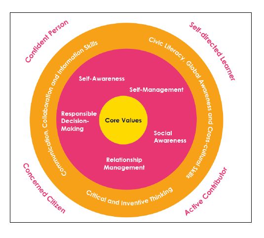
1.1 DESIRED OUTCOMES OF EDUCATION AND THE STUDY OF GEOGRAPHY IN SINGAPORE
The Desired Outcomes of Education (DOE) are attributes that educators aspire for our
learners. These outcomes establish a common purpose for geography teachers, and serve as
a compass to steer the teaching and learning process. The DOE for our learners are:
• a confident person who has a strong sense of right and wrong, is adaptable and
resilient, knows himself, is discerning in judgment, thinks independently and
critically, and communicates effectively;
• a self-directed learner who questions, reflects, perseveres and takes responsibility
for his own learning;
• an active contributor who is able to work effectively in teams, is innovative,
exercises initiative, takes calculated risks and strives for excellence; and
• a concerned citizen who is rooted to Singapore, has a strong civic responsibility, is
informed about Singapore and the world, and takes an active part in bettering the
lives of others around him.
The Lower Secondary Geography syllabuses will enable students to acquire a wide range of
knowledge and skills to understand and explain physical and human phenomena; and other
contemporary environmental and social issues that occur in different places and cultures.
Equipped with the skills of gathering and analysing information, and an inquiring mind to seek
answers to issues affecting our lives and the world we live in, geography students will be
prepared for their roles as informed citizens in the 21st century. The subject also imbibes in
students an awareness of appropriate attitudes and values that promotes a positive
geographical future; one that ensures the sustainability of our resources, people, country,
and planet. An illustration of how Geography contributes towards the DOE in the Singapore
education system is shown in Figure 1.
2Figure 1: Desired Outcomes of Singapore’s Education through Geography
1.2 21ST CENTURY COMPETENCIES IN GEOGRAPHY
To nurture world ready students, the Lower Secondary Geography syllabuses equip students
with the necessary knowledge, skills and values to succeed in the 21st Century (see Figure 2).
Figure 2: 21st Century Competencies in Geography
3With its adoption of an issue-based approach focussing on contemporary geographical issues,
the syllabuses provide students with an opportunity to explore geographical questions.
Moreover, with the recommended use of inquiry, students learn to search for geographical
data from a variety of sources in a discerning and responsible manner; developing
communication, collaboration and information skills in the process. In analysing data and
drawing connections to theory learnt, students exercise critical thinking. The examples and
case studies help students understand why people in other places may see and construct the
world differently. This promotes civic literacy, global awareness and cross-cultural skills.
1.3 AIMS OF LOWER SECONDARY GEOGRAPHY SYLLABUSES
The syllabuses aim to enable students to:
• develop an interest in geography;
• acquire geographical knowledge and develop a basic understanding of geography as
a discipline/subject;
• gain global awareness of current geographical issues and future challenges;
• learn the process of geographical inquiry and to use it to make sense of new
knowledge;
• develop skills in acquiring, communicating and applying geographical knowledge;
and
• develop a concern for the environment and make informed judgments about human
action/behaviour.
Learning Outcomes
Knowledge and Understanding
The syllabus intends for students to develop knowledge of:
• geographical concepts, terms and facts;
• components of physical and human environments;
• diverse spatial patterns of physical and human phenomena/features;
• relationships and interactions between and within physical and human phenomena
at local, regional and global scales; and
• different approaches through which challenges faced can be managed by local,
regional and global communities.
Skills
The syllabuses intend for students to develop the skills to:
• work effectively in teams to observe, collect and record geographical data obtained
from both primary and secondary sources;
• derive knowledge and understanding from field experiences of places and natural
environments;
• interpret maps, atlases, tables, graphs, photographs and fieldwork data;
• recognise patterns in geographical data and suggest relationships; and
• organise and present geographic information in a coherent way.
4Values
Through their geographical training, students should develop:
• an interest in, and valuing of, the ways that the environment supports life;
• a sense of appreciation, care and responsibility for the quality of the environment;
and
• sensitivity towards the attitudes, beliefs and values of people of different cultures.
1.4 THINKING GEOGRAPHICALLY
Geography provides students with a particular set of perspectives to make sense of Singapore
and the complex and dynamically changing world. Central to understanding geography’s way
of thinking/perspective are a number of key concepts such as space, place scale, physical and
human processes, environmental and cultural diversity, and interdependence.
The key concepts provide valuable insights into the nature of Geography because of their
breadth of application to the content studied and the extent to which they are linked to other
significant ideas within the subject. The key concepts may be used individually or in
combination. For example, the use of place helps students understand why people originally
settled along the banks of Singapore River and how Singapore has developed and changed
over time. The concept of environment helps students to analyse the changes humans make
to natural environments and better appreciate their impact so that the changes can be
managed more wisely.
As students grow in familiarity with these key concepts, they will learn to put on the
geographical lens, that is to think geographically to understand contemporary issues like
deforestation, water shortage, energy crisis, floods, housing shortage and traffic congestion
(see Figure 3).
Figure 3: Four Key Geographical Concepts
52. PEDAGOGY
2.1 GEOGRAPHICAL INQUIRY
The geographical inquiry approach seeks to empower students in their own learning and
stimulate an interest in the subject. It provides students with the opportunity to ‘ask relevant
questions, to pose and define problems, to plan what to do and how to research, to predict
outcomes and anticipate consequences, and to test conclusions and improve ideas.’ 1
Figure 4: Geographical Inquiry Process
The framework for learning through inquiry (see Figure 4) begins with sparking curiosity
through the use of stimulus materials to challenge students’ assumptions and habitual
responses and invite posing of questions. Thereafter through library research and fieldwork,
geographical data is gathered. As students systematically organise the information they have
collected, they will need to exercise sound reasoning to analyse and make connections
between the pieces of information they have, and thereby construct new knowledge for
themselves. They will analyse the information in the light of the question posed so as to arrive
at a conclusion to the question before reflecting on their learning based on the inquiry process
or conclusion drawn. Through the inquiry process, students will be challenged to examine
their own thinking, feeling and doing and become self-reflective thinkers. These four aspects
of sparking curiosity, gathering data, exercising reasoning and reflective thinking serve as the
basic thinking processes that students will go through in a geographical inquiry.
1
Roberts, M. (2003). Learning through Enquiry: Making Sense of Geography in the Key Stage 3 Classroom. UK:
Geographical Association.
63. CONTENT
3.1 ISSUES-BASED FRAMEWORK
The Lower Secondary Geography syllabuses adopt an issue-based framework whereby
students acquire an understanding of Geography through the study of significant
environmental and human issues confronting Singapore and the world.
Using such an approach, each issue is unpacked systematically through a set of guiding
questions:
• What is the issue? Which part(s) of the world is/are affected by the issue?
• Why is the issue located there?
• How does the issue affect human society and natural environments?
• How should it be managed?
Collectively these questions represent a way geographers unpack and investigate an issue and
are underpinned by the four key geographical concepts of place, space, environment and
scale.
3.2 SYLLABUS THEMES
3.2.1 Theme on Environment and Resources
At Secondary 1, the theme of Environment and Resources introduces students to the
biophysical environment that supports life on Earth. Students learn how natural resources
(e.g. forests, water and fossil fuels) are produced and sustained by environmental processes.
They get to know how people value and use these resources, and how human activities affect
their continual supply. Through the use of examples, students learn about the opportunities
and constraints that these resources pose for human life and economic activity. They also
study how the resources are being managed in selected countries and examine how these
resources can be used in a sustainable manner.
3.2.2 Theme on Urban Living
In the second theme on Urban Living, students are introduced to the issues such as housing
shortage, traffic congestion and floods. Through the use of examples, students learn how
cities have adopted different strategies to manage these issues. They will appreciate the
importance of planning and understand how changes to the urban landscape can directly
affect them, and have an impact on their quality of life.
73.3 Overview of Lower Secondary Geography Express Course Syllabus
The Express Course syllabus comprises two introductory topics and six issues (see Figure 5).
In Secondary One, there is an introduction on what students will learn in Geography. This
topic inducts them into sub-fields of the subject (i.e. aspects of physical and human
geography), methods of inquiry, data collection, analysis and representation. This is followed
by an in-depth study of three issues on the first theme of ‘Environment and Resources’. The
three issues are Deforestation, Water Shortage and Energy Crisis.
For Secondary Two, there is an introduction to how and where people live. This topic explores
the development of human society to present-day features of cities is provided to enable
students to gain a broad understanding of how and where people live across time and space.
This is followed by an in-depth study of three issues on the second theme of ‘Urban Living’,
namely Housing Shortage, Traffic Congestion and Floods.
See Section 3.6 for the amplification of the syllabus.
Figure 5: Issues in the Express Course Syllabus
Theme 1: Environment and Resources
Introduction: What will we learn in Geography?
Issue 1: Tropical rainforest – How can we save the rainforest?
1 What are tropical rainforests and what is deforestation?
2 Where are tropical rainforests found and which areas have been deforested? Why
does deforestation occur?
3 How does deforestation impact people and the environment?
4 How should we manage deforestation?
Issue 2: Water Supply – Will our taps run dry?
1 What is water shortage?
2 Which locations in the world are facing water shortage? Why does water shortage
occur?
3 How does water shortage impact people and countries?
4 How can Singapore avoid water shortage?
Issue 3: Energy Crisis – How can we avoid an energy crisis?
1 What is an energy crisis?
2 Is the level of energy consumption the same everywhere? Why do they differ?
3 How would an energy crisis impact society?
4 How can an energy crisis be avoided?
Theme 2: Urban Living
Introduction: How and where do people live?
Issue 4: Housing – How to provide homes for all?
1 What is housing shortage?
2 Which cities in the world experience housing shortage? Why does housing shortage
occur?
3 What are the consequences of housing shortage in cities?
84 What are some strategies used by cities to manage housing shortage and build
inclusive homes?
Issue 5: Transport – How do we keep people moving?
1 What is traffic congestion?
2 Where is traffic congestion found in the city and why does it occur?
3 How does traffic congestion affect people and the environment?
4 How do some cities manage traffic congestion?
Issue 6: Floods – How can cities prepare for floods?
1 What are floods?
2 Which cities are prone to floods? Why are these cities more prone to floods than
others?
3 How do floods affect people living in cities?
4 How should cities prepare for floods?
3.4 Overview of Lower Secondary Geography Normal (Academic) Course Syllabus
The N(A) syllabus comprises two introductory topics and four selected issues (see Figure 6).
In Secondary One, there is an introduction on what students will learn in Geography. This
topic inducts them into sub-fields of the subject (i.e. aspects of physical and human
geography), methods of inquiry, data collection, analysis and representation. This is followed
by an in-depth study of two issues on the first theme of ‘Environment and Resources’. The
two issues are Deforestation and Water Shortage.
For Secondary Two, there is an introduction to how and where people live. This topic explores
the development of human society to present-day features of cities is provided to enable
students to gain a broad understanding of how and where people live across time and space.
This is followed by an in-depth study of two issues on the second theme of ‘Urban Living’,
namely Housing Shortage and Floods.
See Section 3.6 for the amplification of the syllabus.
Figure 6: Issues in the Normal (Academic) Course Syllabus
Theme 1: Environment and Resources
Introduction: What will we learn in Geography?
Issue 1: Tropical rainforest – How can we save the rainforest?
1 What are tropical rainforests and what is deforestation?
2 Where are tropical rainforests found and which areas have been deforested? Why
does deforestation occur?
3 How does deforestation impact people and the environment?
4 How should we manage deforestation?
Issue 2: Water Supply – Will our taps run dry?
1 What is water shortage?
2 Which locations in the world are facing water shortage? Why does water shortage
occur?
93 How does water shortage impact people and countries?
4 How can Singapore avoid water shortage?
Theme 2: Urban Living
Introduction: How and where do people live?
Issue 3: Housing – How to provide homes for all?
1 What is housing shortage?
2 Which cities in the world experience housing shortage? Why does housing shortage
occur?
3 What are the consequences of housing shortage in cities?
4 What are some strategies used by cities to manage housing shortage and build
inclusive homes?
Issue 4: Floods – How can cities prepare for floods?
1 What are floods?
2 Which cities are prone to floods? Why are these cities more prone to floods than
others?
3 How do floods affect people living in cities?
4 How should cities prepare for floods?
3.5 Geographical Investigations
Geographical Investigation (GI) is integral to learning Geography and reflects the importance
of inquiry. GI provides students with opportunities to:
• carry out a more student-directed geographical inquiry, and participate in fieldwork,
as students are required to go beyond the classroom to actively look for and gather
data to address the inquiry;
• apply and transfer what they have learnt from their geography lessons to a real world
issue;
• be assessed more holistically in terms of a wider range of geographical skills; and
• develop the skills and attitudes to work individually and collaboratively in groups as
students are required to complete both individual and group components.
Each issue is designed with an accompanying geographical investigation (GI) (see Figure 7).
Students work in groups on one selected GI a year.
See Section 3.6 for the amplification of the syllabus.
10Figure 7: Overview of Geographical Investigations
Issues Geographical Investigation Questions
Tropical rainforest: How do human activities affect our nature reserve/park?
How can we save How can we conserve our nature reserve/park?
Secondary One
the rainforest?
Water supply: Will What is the quality of water in a waterway or water body?
our taps run dry? How do human activities affect the quality of water in a
waterway or water body?
Energy resources*: How do human activities and attitudes affect the energy
How can we avoid consumption of a school? How can we reduce our school’s
an energy crisis? energy consumption?
Housing: How to What makes some places in the neighbourhood special to
provide homes for its residents?
Secondary Two
all?
Transport*: How do What features of our public transport help to ensure a safe
we keep people and comfortable journey?
moving?
Floods: How can How effective are the measures taken to reduce floods in
cities prepare for my neighbourhood? How can we increase residents’
floods? awareness and preparedness towards floords?
*For Express course only.
The GI process mirrors the geographical inquiry process in terms of the stages the students
go through to answer the GI question and complete the group end product (see Figure 8).
Figure 8: Stages of Geographical Investigation
Analyse
the GI
question
Gather
Individual and
reflection select the
data
Present
group Analyse
end data
product
Construct
group
response
11Stages Students should:
Analyse the GI • Ask questions to understand the focus of the GI question
question • Determine the types of data required to answer the GI question
Gather and • Conduct preliminary research using online and print materials
select the data • Acquire fieldwork skills
• Conduct fieldwork
Analyse data • Interpret, analyse and represent data gathered
Construct group • Construct response to the GI question
response
Present group • Present and communicate conclusion using an end-product
end product
Individual • Analyse class data
reflection • Identify strengths, limitations and possible ways of improving
the investigation
123.6 Amplification of Syllabuses
INTRODUCTION | WHAT WILL WE LEARN IN GEOGRAPHY?
Overview
Geography is about the real world and geographers help people to understand our complex and ever-changing world in order to make wise decisions about
our future. Geographers study the world by exploring spatial patterns and relationships between locations at various scales. Geographers also examine
interactions between human society and nature, how places and landscapes are formed (and represented) as well as the interconnections between human
society and natural environments. When studying real world issues, geographers ask geographical questions, conduct fieldwork, analyse geographical data and
think critically about possible solutions to ensure a sustainable future for all.
Guiding Question Content
What will we learn in • Branches of Geography
Geography? o Physical Geography
Atmosphere, Biosphere, Hydrosphere, and Lithosphere
o Human Geography
Population, Settlements, Development and Culture
• Geographical Concepts
o Place
o Space
o Scale
o Environment
• Geographical Inquiry
o Geographical Questions
What is the issue?
Which part(s) of the world is/are affected by the issue? Why does this issue occur?
How does the issue affect human society and natural environments?
How should the issue be managed?
o Geographical Data Collection and Analysis
Fieldwork (i.e. primary data collection and analysis)
o Geographical Data (i.e. graphs, maps, photographs, sketches, tables and text/quotes
13ISSUE 1 | TROPICAL RAINFOREST: HOW CAN WE SAVE THE RAINFOREST?
Overview
A tropical rainforest is one of the world’s natural ecosystems. Rainforests which once covered 14% of the earth’s land surface, now cover a mere 6%. There is
a wide variety of plant and animal species in the tropical rainforest. These plants and animals have adapted to the hot and wet environment of the rainforest.
Over the past 40 years, about a fifth of the Amazon rainforest has been deforested. In Southeast Asia, many countries have also lost large areas of their
rainforests. The study of the tropical rainforests has become crucial as there is a greater threat to the forests now due to increased demand for timber, land
for agriculture, cattle ranching, housing, industrial activities, mining and transport infrastructure.
In this issue, students will study the characteristics of the tropical rainforests and their uses to people. Through the study of the causes of deforestation of the
Amazon rainforest and the consequent problems, students will understand the importance of tropical rainforests. They will examine the measures for
sustainable use of tropical rainforests and the challenges involved in making decisions about such use.
Guiding Questions Learning Outcomes Content Concepts Main Terms
Students should be able to:
What are tropical • Describe the characteristics of • Characteristics of tropical rainforest as broad- Geographical • Tropical
rainforests and tropical rainforests using leafed, mainly evergreen trees Concept rainforest
what is photographs and sketches. o Structure • Environment • Canopy
deforestation? • Describe how tropical o Adaptation • Emergent
rainforests adapt to the o Diversity of plant species Content Concept • Undergrowth
tropical climate. • Deforestation is the cutting down and removal • Renewable • Buttress root
• Describe the uses and of all or most of the trees in a forested area. resource • Evergreen
importance of tropical • Uses of tropical rainforests: • Structure • Drip-tip leaves
rainforests. o Water catchment • Adaptation • Water
• Respect the different o Green Lungs of the Earth • Biodiversity catchment
perspectives people have o Habitat to flora and fauna, and indigenous • Green Lungs of
about rainforests. people the Earth
• Define deforestation. o Source of timber • Flora
o Medical application • Fauna
• Timber wood
• Medical
application
• Deforestation
Where are tropical • Describe the distribution of • Global distribution of tropical rainforest is Geographical • Equatorial
rainforests found tropical rainforests and its influenced by climate Concept climate
and which areas deforestation using maps. • Distribution of tropical rainforest in Singapore • Space • Agriculture
14have been • Describe the rate of • Global distribution of deforested areas of • Scale • Cattle ranching
deforested? Why deforestation using graphs and tropical rainforest • Logging
does deforestation tables. • Causes of deforestation: • Mining
occur? • With reference to named o Agriculture
examples, explain the causes of o Cattle ranching
deforestation. o Logging
o Mining
How does • Describe the impact of • Impact of deforestation on people and the Geographical • Loss of
deforestation deforestation on people and environment: Concept biodiversity
impact people and the environment using o Environment • Place • Extinction
the environment? text/quotes. Loss of biodiversity • Environment • Flood risk
• Show concern for people and Loss of water catchment • Water quality
environment as a result of Increase risk of flooding with soil Content Concept • Soil erosion
massive deforestation in some erosion and sedimentation • Economic • Enhanced
parts of the world. Enhanced greenhouse effect development greenhouse
o Economic • Sedimentation effect
Depletion of natural resources
o Social
Effect on indigenous people
How should we • Describe the measures taken • Conservation of tropical rainforest in Singapore Geographical • Conservation
manage to manage deforestation in the and other countries Concept • Protection
deforestation? Amazon and conserve the o Protection of forested areas • Place • Reforestation
rainforest in Singapore. o Reforestation • Scale • Controlled
• Explain the measures taken to o Controlled logging logging
manage deforestation in the o Public education Content Concept
Amazon and conserve the • Legislation
rainforest in Singapore. • Sustainable
• Describe the benefits and resource
challenges of measures taken management
to manage deforestation in the
Amazon and conserve the
rainforest in Singapore.
15GEOGRAPHICAL INVESTIGATION 1 | HOW DO HUMAN ACTIVITIES AFFECT OUR NATURE RESERVE/PARK?
HOW CAN WE CONSERVE OUR NATURE RESERVE/PARK?
Rationale and Aims
Nature Reserves/ Parks are important green spaces in our living environment. They are valuable places for recreation, conservation, research and education.
In the case of Singapore, the government has created green spaces through the creation of nature reserves and parks, which help to increase the liveability of
our living environment. This geographical investigation provides you with an opportunity to explore the human activities taking place in a nature reserve/park
and examine the strategies to conserve the nature reserve/park.
The aims of this geographical investigation are to:
1. explain how human activities (e.g. by individuals, non-governmental organisations and government agencies) can affect a nature reserve/ park; and
2. suggest ways we (e.g. individuals, non-governmental organisations and government agencies) can conserve a nature reserve/ park.
Learning Outcomes
Students should be able to: Skills
Knowledge Sparking Curiosity
• Explain how human activities (e.g. by individuals, non-governmental • Pose questions to guide their investigation.
organisations and government agencies) can affect a nature reserve/ Gathering Data
park. • Identify relevant information via library and online searches.
• Describe the ways we (e.g. individuals, non-governmental organisations • Apply random and systematic sampling appropriately.
and government agencies) can conserve a nature reserve/ park. • Observe and sketch the assigned sites and its features.
• Observe and take photographs of the assigned sites and its features.
Values/Attitudes Exercising Reasoning
• Appreciate the importance of our nature reserves/ parks and Data Presentation
understand the need for conservation. • Organise and present data through maps, tables, graphs, photographs and
• Understand that everyone has a role to play in conserving our nature quotes.
reserves/parks. Data Interpretation and Draw Conclusions
• Explain the data meaningfully, draw comparisons and identify relationships
in order to arrive at reasoned conclusions.
Reflective Thinking
• Describe the strengths and limitations of the investigation.
• Suggest how the investigation can be improved.
16ISSUE 2 | WATER SUPPLY: WILL OUR TAPS RUN DRY?
Overview
Water is a necessity to human life and as an input to agriculture and industries found in many countries. Without this resource, life as we know it would be
impossible. As water is so readily available in Singapore, sometimes we take our water supply for granted. We may not be aware that our taps can run dry one
day if our usage remains unabated and intervention measures are not taken to boost supply.
This issue introduces students to the issue of water shortage, which is defined here as usage exceeding available supply. Students will learn that Earth’s
freshwater supply is actually very limited. However due to increasing demand, the pressure on scarce water supplies is mounting. They will examine the causes
and problems arising from water shortage as well as how Singapore has taken steps to avoid water shortage. Through this issue, it is envisioned that students
would come to value water as a precious resource which has to be protected and used wisely.
Guiding Questions Learning Outcomes Content Concepts Main Terms
Students should be able to:
What Is water • Explain the hydrological cycle. • Renewable supply of water through the Geographical • Hydrological
shortage? • Identify the uses of water with hydrological cycle Concept cycle
reference to graphs. • Uses of water • Place • Precipitation
• Define water shortage. o Domestic (e.g. drinking, washing, cooking) • Environment • Evaporation
o Economic (e.g. irrigation in agriculture and • Condensation
wafer fabrication) Content Concept • Transpiration
• Water shortage • Renewable • Surface runoff
• Level of water usage exceeding available water resource • Infiltration
supply • Water footprint • Groundwater
• Water shortage
Which locations in • Describe the global distribution • Distribution of water on Earth Geographical • Glaciers
the world are of water using maps. o Oceans Concept • Ice caps
facing water • Identify countries and regions, o Freshwater in underground and surface • Space • Lakes
shortage? Why which are facing water storages • Scale • Rivers
does water shortage using graphs, maps • Locations in the world facing water shortage • Climate Change
shortage occur? and tables. (e.g. northern Africa due to physical factors Content Concept • Pollution
• With reference to named and central China due to human factors) • Water as a global
examples, explain the causes of • Causes of water shortage system
water shortage. o Demand
• Appreciate that although Earth Population growth
is a water planet, water Affluence
o Supply
17conservation is crucial as Seasonal rainfall
freshwater supply is limited. Water pollution
How does water • Describe the impact of water • Impact of water shortage on people and the Geographical • Yield
shortage impact shortage on people and the environment: Concept • Cost of
people and the environment using o Domestic • Place industrial
environment? photographs, sketches and Increased difficulty in collecting water • Environment production
text/quotes. (e.g. Mali), water rationing (e.g.
Singapore in the 1960s) Content Concept
o Economic • Human
Reduced agricultural yields (e.g. India) development
Increased cost of industrial production
o Political
Conflict over water supply (e.g.
Mekong)
How can Singapore • Describe the measures taken • Water resource management in Singapore Geographical • Surface
avoid water to avoid water shortage in o Reduce water consumption Concept catchment
shortage? Singapore. Pricing (Water consumption tax) • Place • Reverse
• Explain the measures taken to Public education • Scale osmosis
avoid water shortage in o Increase water supply • Desalination
Singapore. Local catchment water (e.g. Marina Content Concept
• Describe the advantages and Barrage/Reservoir) • Legislation
disadvantages of various Imported water (e.g. Singapore – • Public education
measures to avoid water Malaysia water agreements) • Sustainable
shortage in Singapore. NEWater resource
• Appreciate human ingenuity in Desalinated water management
developing technology to o Conservation
overcome water shortage. Protection of water resources
18GEOGRAPHICAL INVESTIGATION 2 | WHAT IS THE QUALITY OF WATER IN A WATERWAY OR WATER BODY?
HOW DO HUMAN ACTIVITIES AFFECT THE QUALITY OF WATER IN A WATERWAY OR WATER BODY?
Rationale and Aims
In Singapore, various strategies are used to increase our water supply. Currently, our water catchment areas constitute two-thirds of Singapore’s total land
area. Waterways (e.g. rivers, canals) and water bodies (e.g. lakes, reservoirs and ponds) are interconnected and form part of the catchment area. They are
often found close to where people live and work. Human activities can affect the quality of water in the waterways and water bodies. It is important to ensure
good water quality to support aquatic life and cater to the needs of people. This geographical investigation provides you with an opportunity to explore a
waterway or water body, its water quality and the impact of human activities on water quality.
The aims of this geographical investigation are to:
1. determine if the quality of water in a waterway or a water body is suitable for use by humans and able to support freshwater fishes; and
2. discuss how human activities (e.g. by individuals, industries and government agencies) could affect water quality.
Learning Outcomes
Students should be able to: Skills
Knowledge Sparking Curiosity
• Explain how water quality is measured and the acceptable range for use • Pose questions to guide their investigation.
by humans and to support freshwater fishes. Gathering Data
• Describe how human activities (e.g. by individuals, industries and • Identify relevant information via library and online searches.
government agencies) affect the quality of water in Singapore and the • Apply random and systematic sampling appropriately.
assigned waterway or water body. • Observe and sketch the assigned sites and its features.
• Observe and take photographs of the assigned sites and its features.
Values/Attitudes • Use equipment to gather data
• Appreciate water as a precious resource and the need for water Exercising Reasoning
conservation. Data Presentation
• Understand that everyone has a role to play in water conservation. • Organise and present data through maps, tables, graphs, photographs and
• Be aware that varying levels of water quality is required to support quotes.
aquatic life and cater to the needs of people. Data Interpretation and Draw Conclusions
• Explain the data meaningfully, draw comparisons and identify relationships
in order to arrive at reasoned conclusions.
Reflective Thinking
• Describe the strengths and limitations of the investigation.
• Suggest how the investigation can be improved.
19ISSUE 3 | ENERGY RESOURCES: HOW CAN WE AVOID AN ENERGY CRISIS? 2
Overview
The bulk of our energy needs today are met by fossil fuels (i.e. coal, oil and gas) that are formed some hundreds of millions of years ago. This finite resource
however is being rapidly depleted as a result of population increase, industrial growth and rising affluence worldwide. Compounding this problem is the
frequent disruption to energy supplies as a result of unexpected weather conditions and socio-political problems in fossil fuel producing countries. A shortage
of fossil fuels will result in various socio-economic problems and may even spark wars. In order to avoid the energy crisis, we need to find ways to use energy
more efficiently as well as alternative sources of energy.
In this issue, students will learn about the different types of fossil fuels as well as energy resources that humans had relied on in the past. They would be
introduced to the features of an energy crisis and analyse the patterns of energy consumption in Singapore and selected countries. After exploring the socio-
economic impact of an energy crisis, they will assess the strategies to avert an energy crisis.
Guiding Questions Learning Outcomes Content Concepts Main Terms
Students should be able to:
What is an energy • Describe the uses of fossil fuels. • Energy Resources Geographical • Energy
crisis? • Explain how fossil fuels are o Early sources Concept Resources
formed. Animals • Space • Renewable
• Describe the features of an Firewood • Environment resource
energy crisis. Wind power • Non-renewable
o Fossil fuels Content Concept resource
• Types of fossil fuels: coal, oil and natural gas • Utilitarian value • Fossil Fuels
o Formation and distribution of fossil fuels • Environmental • Rock Cycle
o Uses of fossil fuels and its associated depletion • Sedimentary
environmental problems Rock
• Energy Crisis
o Depletion of fossil fuel reserves
o Increase in energy costs
Is the level of • Locate countries and regions • Energy Consumption of Singapore and Selected Geographical • Energy
energy that consume high levels of Countries (e.g. China and USA) Concept Consumption
consumption the energy with the use of maps. o Current level of consumption • Place • Industrial
same everywhere? • Describe the pattern of energy o Past and future rate of growth • Space Growth
Why do they consumption in the world with • Reasons for High Energy Consumption • Scale
differ? the use of graphs and tables.
2
For Express Course only.
20• With reference to selected o Industrial growth (e.g. China, India, Content Concept
countries, explain why energy Singapore) • Carbon footprint
consumption has risen in o Affluence (e.g. USA) • Human
recent decades. development
• Recognise that one’s lifestyle
decision impacts others and the
natural environment.
How would an • Explain how an energy crisis • Impact of Increased Energy Costs Geographical • Cost of Living
energy crisis could impact society with the o Social Concept • Competitivenes
impact society? use of photographs, sketches Frequent interruption to electricity • Place s
and text/quotes. supply
Increased cost of living Content Concept
o Economic • Standard of
Reduced competitiveness living
How can an energy • Describe the measures to • Reduce Energy Consumption (e.g. Singapore) Geographical • Solar Power
crisis be avoided? reduce energy consumption in o Energy conservation Concept • Wind Power
Singapore and the world. o Efficient use of energy • Environment • Hydropower
• Describe the strategies of • Alternative Energy Sources • Scale • Nuclear Energy
adapting to declining fossil fuel o Solar power (e.g. USA)
reserves. o Wind power (e.g. Denmark) Content Concept
• Explain the strategies of o Hydropower (e.g. China) • Sustainable use
adapting to declining fossil fuel o Nuclear energy (e.g. France) of resources
reserves.
• Describe the advantages and
disadvantages of the different
strategies of adapting to
declining fossil fuel reserves.
• Respect the views and opinions
of others that may not be in
agreement with one’s own.
21GEOGRAPHICAL INVESTIGATION 3 | HOW DO HUMAN ACTIVITIES AND ATTITUDES AFFECT THE ENERGY CONSUMPTION OF A SCHOOL?
HOW CAN WE REDUCE OUR SCHOOL’S ENERGY CONSUMPTION? 3
Rationale and Aims
Our dependence on fossil fuels to meet increasing energy needs has contributed to a rise in the level of carbon emissions. This results in climate change which
is said to be one of the greatest challenges facing human society in this century. There has been considerable evidence that links climate change to human
activities. Thus, it is important for us to understand how our everyday activities and decisions can significantly affect global carbon emissions. Conducting an
energy audit is one way to evaluate the individuals’, households’ and organisations’ impact on the environment as it can show us how efficiently we use energy.
The geographical investigation provides you with an opportunity to identify areas in the school with high/low energy consumption; discover human activities
and attitudes that contributed to the school’s amount of energy consumed and examine ways in which energy consumption may be reduced.
The aims of this geographical investigation are to:
1. determine the areas of high/low energy consumption in a school; and
2. discuss how human activities and attitudes affect a school’s energy consumption and suggest ideas to reduce it.
Learning Outcomes
Students should be able to: Skills
Knowledge Sparking Curiosity
• Describe how human activities and attitudes (e.g. values/ awareness of • Pose questions to guide their investigation.
students, teaching staff and non-teaching staff) affect the energy Gathering Data
consumption of a school. • Identify relevant information via library and online searches.
• Describe the ways in which we (i.e. students, teaching staff and non- • Apply random and systematic sampling appropriately.
teaching staff) can reduce our school’s energy consumption. • Construct a questionnaire and conduct interviews.
• Observe and take photographs of the assigned sites and its features.
Values/Attitudes • Conduct an energy audit
• Appreciate energy as a precious resource and the need for energy Exercising Reasoning
conservation. Data Presentation
• Understand that everyone has a role to play in energy conservation. • Organise and present data through maps, tables, graphs, photographs and
quotes.
Data Interpretation and Draw Conclusions
• Explain the data meaningfully, draw comparisons and identify relationships
in order to arrive at reasoned conclusions.
Reflective Thinking
3
For Express Course only.
22• Describe the strengths and limitations of the investigation. • Suggest how the investigation can be improved. 23
INTRODUCTION | HOW AND WHERE DO PEOPLE LIVE?
Overview
How and where people live is closely connected to the nature of human society. Although a large proportion of the world population lives in cities today, urban
living was in fact uncommon in human history. For much of human existence, people lived among nomadic bands that hunted wild animals and gathered food.
Subsequently, people became more rooted when agriculture appeared. People invested in farms to cultivate crops and practice animal husbandry. Since the
late 18th century, people started to live in close proximity as more housing was built in existing built-up areas to meet the needs of the expanding working
class. To facilitate the mass production and transportation of goods, cities were often established near waterways (e.g. rivers), sources of energy supply (e.g.
coalfields) or raw materials (e.g. forests). Today, cities continue to grow in population size as a result of natural increase and rural-urban migration.
Guiding Question Content
How and where do people live? • Development of Human Society
o Hunter-gatherer society
Hunt wild animals
Gather food from flora
Nomadic
o Agrarian society
Cultivate plants
Domesticate animals
Sedentary
o Industrial society
Commercial farming
Mass production of goods
Industrial cities
o Location of industrial cities
Waterways (e.g. Shanghai)
Source of energy supply (e.g. Newcastle)
Source of raw materials (e.g. Seattle)
• Features of cities
o Large population size due to natural increase and rural-urban migration
o High population density
o Cosmopolitan population
o Built-up
24ISSUE 4 | HOUSING: HOW TO PROVIDE HOMES FOR ALL?
Overview
With the turn of the 21st century, increasing numbers of people are moving to cities in search of better opportunities. This trend and the large number of
young people, in their reproductive years, living in cities have resulted in rapid population growth in many cities around the world, including Singapore. Since
2007 more than half of the world’s population live in cities.
This issue introduces students to the issue of housing shortage faced by many cities. Through examples, students will learn that rapid population growth often
lead to housing shortage in cities. This results in poor living conditions, environmental pollution and social tension. Students will study the various approaches
used by cities to manage housing shortages and meet the diverse needs of its residents, including the elderly. They will appreciate that housing shortage is a
complex issue and requires multi-pronged solutions.
Guiding Questions Learning Outcomes Content Concepts Main Terms
Students should be able to:
What is housing • Define housing shortage. • Housing shortage Geographical • Housing
shortage? • Describe the nature of housing o Lack safe shelter Concept shortage
shortage using photographs o Insufficient basic services • Place • Slums and
and sketches. squatter
Content Concept settlements
• Carrying capacity
Which cities in the • Identify the location of cities • Location of cities that experience housing Geographical • Migration
world experience experiencing housing shortage shortage Concept • Rural-urban
housing shortage? using maps. • Reasons for housing shortage • Place migration
Why does housing • Describe the extent of housing o Rapid population growth • Space • Birth rates
shortage occur? shortages in cities using graphs Rural-urban migration
and tables. High birth rates Content Concept
• Using named examples of o Competing landuse • Urbanisation
cities, explain the reasons for o Limited supply of land
housing shortage.
What are the • Describe the consequences of • Consequences of housing shortage Geographical • Homelessness
consequences of housing shortage using o Homelessness Concept • Social tension
housing shortage in photographs, sketches and o Slums and squatter settlements • Place • Pollution
cities? text/quotes. Environmental pollution • Environment
• Show concern for people who Low level of health due to poor living
live in poor quality housing. conditions Content Concept
Vulnerability
25• Environmental
degradation
What are some • Describe and explain the • Strategies to manage housing shortage Geographical • Self-help
strategies used by strategies used by Singapore o Slum upgrading Concept scheme
cities to manage and other cities to manage o Provision of public housing • Place • Public housing
housing shortage housing shortage. • Inclusive housing • Scale • New towns
and build inclusive • Describe the strategies used by o Affordable housing • Private sector
homes? Singapore to build inclusive o Facilities and amenities for all ages Content Concept
homes. o Strong sense of place and belonging • Legislation
• Explain the challenges faced by • Government
Singapore and other cities to policy
manage housing shortage.
• Respect the resilience shown
by people to improve their
living conditions.
26GEOGRAPHICAL INVESTIGATION 4 | WHAT MAKES SOME PLACES IN THE NEIGHBOURHOOD SPECIAL TO ITS RESIDENTS?
Rationale and Aims
Housing is a challenging and complex issue faced by many cities today. Though Singapore does not face the problem of widespread housing shortages, it is
critical that Singapore provides inclusive housing for its people. The neighbourhood contains many gathering places of everyday life. It is a place where
interactions among residents often happen and over time, residents gradually develop a strong sense of place and belonging (i.e. sense of familiarity and
attachment) to the neighbourhood. However, as people identify and relate to the neighbourhood in different ways, the relationships and memories formed,
and meanings that residents attach to these places would also be different. This geographical investigation provides you with an opportunity to explore the
neighbourhood, discover places that are special to its residents and understand their reasons why these places are special to them as well as how the
characteristics of these places may contribute to the residents’ sense of familiarity and attachment.
The aims of this geographical investigation are to:
1. discover places in the neighbourhood that are special to the residents and understand the reasons why; and
2. understand that different residents may feel differently about the different places in the neighbourhood.
Learning Outcomes
Students should be able to: Skills
Knowledge Sparking Curiosity
• Describe the characteristics (e.g. natural, cultural, aesthetical design) of • Pose questions to guide their investigation.
places and explain the reasons that may make some places in Gathering Data
neighbourhoods special to different groups of residents. • Identify relevant information via library and online searches.
• Describe the profile of the residents, the history, development and • Apply random and systematic sampling appropriately.
characteristics of the assigned neighbourhood. • Construct a questionnaire and conduct interviews.
• Observe and take photographs of the assigned sites and its features.
Values/Attitudes Exercising Reasoning
• Appreciate the uniqueness of a neighbourhood. Data Presentation
• Appreciate that people hold different meanings about their • Organise and present data through maps, tables, graphs, photographs and
neighbourhood. quotes.
Data Interpretation and Draw Conclusions
• Explain the data meaningfully, draw comparisons and identify relationships
in order to arrive at reasoned conclusions.
Reflective Thinking
• Describe the strengths and limitations of the investigation.
• Suggest how the investigation can be improved.
27ISSUE 5 | TRANSPORT: HOW DO WE KEEP PEOPLE MOVING? 4
Overview
Rapidly increasing populations are a problem in all large cities throughout the world. With increasing population, comes the issue of mobility in cities. People
in cities have to commute daily between their homes and work places. They have to commute as they work in one place and live in another place.
In this issue, students will learn about the challenges associated with mobility and how different cities have used a range of measures to move masses of people
in an affordable manner. Some cities build more roads and highways, yet others have an efficient public transport system. Students will learn how some cities
integrated transport and land use strategy to reduce traffic problems and improve the urban environment. In such cities, development is shifted to areas
outside the city centre that are served by mass rapid transit and expressways. From the study, students will also appreciate the need to reduce car usage and
accept alternative modes of urban transport.
Guiding Questions Learning Outcomes Content Concepts Main Terms
Students should be able to:
What is traffic • Describe the characteristics of • Characteristics of urban transport: Geographical • Mobility
congestion? urban transport using o Variety of transport modes Concept • Modes of
photographs and sketches. o Density of transport network • Place transport-
• Define traffic congestion. o Quality of transport infrastructure tation
• Traffic congestion Content Concept • Traffic
o A situation where there are more vehicles • Carrying capacity congestion
than the road can handle • Public
o Characterised by slower speeds, longer trip transport
times, and increased vehicular queue • Private
transport
• Infrastructure
Where is traffic • Describe the distribution of • Concentration of traffic congestion in the city Geographical • Peak hour
congestion found traffic congestion in the city • Causes of traffic congestion in Singapore and Concept • Transport
in the city and why using maps. other cities • Place services
does it occur? • With reference to Singapore o Separation of work and residential areas • Scale • Commute
and named examples, explain o Movement from one part of the city to
the causes of traffic congestion another to obtain or provide goods and Content Concept
in the city. services • Urbanisation
o Inadequate transport infrastructure and • Landuse
poor provision of transport services planning
4
For Express Course only.
28• Connectivity
• Accessibility
How does traffic • Describe the impact of traffic • Impact of traffic congestion in Singapore and Geographical • Productivity
congestion affect congestion on people and the other cities Concept • Physical health
people and the environment using graphs, o People • Place • Mental health
environment? tables and text/quotes. Reduced productivity • Environment • Smog
• Show concern for people who Stress on physical and mental health
live in cities with severe traffic o Environment Content Concept
congestion. Air pollution (e.g. smog) • Environmental
Noise pollution degradation
• Quality of life
How do some cities • Describe and explain the • Measures taken to manage traffic congestion Geographical • Road pricing
manage traffic strategies used by Singapore in Singapore Concept • Car pooling
congestion? and other cities to manage o Making public transport a choice mode • Place • Integrated
traffic congestion. Integrated public transport system • Scale public
• Describe the benefits and Bus lanes schemes transport
challenges of various strategies Increasing capacity and frequency of Content Concept system
used by Singapore and other buses and rails • Legislation
cities to manage traffic o Managing road usage • Government
congestion. Road pricing policy
• Appreciate the challenges Increase parking fees
faced by planners in managing Enhanced traffic monitoring
transport issues. Measures taken by other cities to
manage traffic congestion
o Improving public transport (e.g. Curitiba)
Building an integrated public transport
system
Increasing capacity and frequency
o Other measures
Telecommuting
Encourage cycling (e.g. Copenhagen)
29GEOGRAPHICAL INVESTIGATION 5 | WHAT FEATURES OF OUR PUBLIC TRANSPORT HELP TO ENSURE A SAFE AND COMFORTABLE JOURNEY? 5
Rationale and Aims
Mobility influences the quality of life in cities to a large extent. A majority of the people in the city commute via different modes of public transport, such as
buses, Mass Rapid Transit and Light Rail Transit. Certain features of the public transport such as the presence of barrier gates in train stations and hand rails
for standing passengers, help to ensure a safe and comfortable journey for commuters. This geographical investigation provides you with an opportunity to
explore these features of public transport and understand the different views of commuters on the features of public transport that help to ensure a safe and
comfortable journey.
The aims of this geographical investigation are to:
1. describe and explain the features of public transport that help to ensure a safe and comfortable journey; and
2. understand the different views of commuters on the features of public transport that help to ensure a safe and comfortable journey.
Learning Outcomes
Students should be able to: Skills
Knowledge Sparking Curiosity
• Describe and explain the features of public transport (bus or rail) in • Pose questions to guide their investigation.
Singapore that help to ensure a safe (e.g., top speed limiter in buses) Gathering Data
and comfortable (e.g., air conditioning) journey for commuters. • Identify relevant information via library and online searches.
• Describe the different needs and concerns about safety and comfort • Apply random and systematic sampling appropriately.
of commuters (e.g., adults, elderly, families with young children) using • Construct a questionnaire and conduct interviews.
public transport. • Observe and take photographs of the assigned sites and its features.
Exercising Reasoning
Values/Attitudes Data Presentation
• Appreciate the features of public transport that help to ensure a safe • Organise and present data through maps, tables, graphs, photographs and
and comfortable journey for different groups of commuters. quotes.
• Appreciate that commuters have different views about the features of Data Interpretation and Draw Conclusions
public transport that help to ensure a safe and comfortable journey. • Explain the data meaningfully, draw comparisons and identify relationships in
order to arrive at reasoned conclusions.
Reflective Thinking
• Describe the strengths and limitations of the investigation.
• Suggest how the investigation can be improved.
5
For Express Course only.
30You can also read