Geologic Resource Evaluation Scoping Summary Minute Man NHP & Saugus Iron Works NHS
←
→
Page content transcription
If your browser does not render page correctly, please read the page content below
Geologic Resource Evaluation Scoping Summary
Minute Man NHP & Saugus Iron Works NHS
                                                                  Geologic Resources Division
Prepared by Trista Thornberry-Ehrlich                             National Park Service
September 22, 2008                                                U.S. Department of the Interior

The Geologic Resource Evaluation (GRE) Program provides each of 270 identified natural area
National Park Service (NPS) units with a geologic scoping meeting, a digital geologic map, and a
geologic resource evaluation report. Geologic scoping meetings generate an evaluation of the
adequacy of existing geologic maps for resource management, provide an opportunity for
discussion of park-specific geologic management issues and, if possible, include a site visit with
local geologic experts. The purpose of these meetings is to identify geologic mapping coverage and
needs, distinctive geologic processes and features, resource management issues, and potential
monitoring and research needs. Outcomes of this scoping process are a scoping summary (this
report), a digital geologic map, and a geologic resource evaluation report.

The National Park Service held a GRE scoping meeting for Minute Man National Historical Park
(MIMA) and Saugus Iron Works National Historic Site (SAIR) on July 11, 2007 at Minute Man
National Historical Park in Concord, Massachusetts followed by a site visit to the national historical
park in the afternoon. Tim Connors (NPS-GRD) facilitated the discussion of map coverage and
Bruce Heise (NPS-GRD) led the discussion regarding geologic processes and features at the two
units. Participants at the meeting included NPS staff from the parks, Northeast Temperate Network,
and Geologic Resources Division, geologists from the University of Massachusetts, Boston College,
Wellesley College, and Andover Geologic Consulting as well as cooperators from Colorado State
University (see table 1). This scoping summary highlights the GRE scoping meeting for Minute
Man National Historical Park and Saugus Iron Works National Historic Site including the geologic
setting, the plan for providing digital geologic maps, prioritized lists of geologic resource
management issues, descriptions of significant geologic features and processes, lists of
recommendations and action items, and a record of meeting participants.

Park and Geologic Setting
Minute Man National Historical Park and Saugus Iron Works National Historic Site encompass 970
and 8.5 acres of eastern Massachusetts, respectively. The Battle Road between Lexington and
Concord is a major cultural resource at Minute Man National Historical Park, which commemorates
the start of the Revolutionary War on April 19, 1775. Designated on April 14, 1959, this park covers
three separate units: North Bridge, The Wayside, and Battle Road. Saugus Iron Works National
Historic Site, authorized on April 5, 1968, contains remnants of the first integrated iron works in
North America (ca. 1646-68). Historic structures of the iron works cluster on the banks of the
Saugus River, north of Boston, Massachusetts. Minute Man National Historical Park and Saugus
Iron Works National Historic Site sit within the Concord, MA and Boston North 7.5’-quadrangles,
respectively.

A series of accreted terranes comprise the bedrock underlying eastern Massachusetts including the
Avalon, Nashoba, and Merrimack Terranes. An accreted terrane is a crustal block or fragment that
exhibits distinctive geology, attached onto the margin of a continent as a result of tectonic processes.
A terrane is demonstrably different from surrounding rocks and is usually fault-bounded. The

                                                   1
easternmost terrane, the Avalon Terrane, tangentially collided with North America during the
Acadian orogenic event some 390 million years ago (Ma). Rocks of this terrane include weakly
metamorphosed shelf and shallow marine sediments of the Boston Bay Group, arc volcanics,
gabbroic intrusions, and granites. The Bloody Bluff fault that runs through Minute Man National
Historical Park separates the Avalon Terrane from the Nashoba Terrane to the west. Deformation
along this fault was oblique as the Avalon Terrane subducted beneath the Nashoba Terrane as well
as slid past it. Further west, across the Clinton-Newbury fault zone, is the Merrimack Terrane. The
Nashoba Terrane contains metamorphosed volcanics, volcanogenic sediments, and intrusions of
diorite and tonalite.
Pleistocene glaciers covered eastern Massachusetts and glacial to post-glacial surficial features
dominate the landscape at both park units and strongly influence the historic events there. Glaciers
left mantles of glacial till across the area. Glacial lakes, formed as ice retreated, left lacustrine
sediments as well. Gently undulating hills, muted ridges, broad stream valleys, kettle ponds, and
flatlands of meadows and fields characterize the landscape at Minute Man National Historical Park.
The Sudbury and Assabet Rivers converge to form the Concord River that runs through the North
Bridge unit. Other streams include Mill Brook and Elm Brook. Battle Road runs along a divide
between drainages. Saugus Iron Works National Historic Site is sited along the banks of the Saugus
River approximately 5 km (3 miles) from its confluence with the Atlantic Ocean. Steep banks,
undulating uplands, and relatively flat floodplain areas characterize the landscape at the site. Tidal
influxes mix salt and fresh water in the area creating important estuarine wetland habitat.
Geologic Mapping for Minute Man National Historical Park and Saugus
Iron Works National Historic Site
During the scoping meeting Tim Connors (NPS-GRD) showed some of the main features of the
GRE Program’s digital geologic maps, which reproduce all aspects of paper maps, including notes,
legend, and cross sections, with the added benefit of GIS compatibility. The NPS GRE Geology-
GIS Geodatabase Data Model incorporates the standards of digital map creation set for the GRE
Program. Staff members digitize maps or convert digital data to the GRE digital geologic map
model using ESRI ArcMap software. Final digital geologic map products include data in
geodatabase, shapefile, and coverage format, layer files, FGDC-compliant metadata, and a
Windows HelpFile that captures ancillary map data. Completed digital maps are available from the
NPS Data Store at http://science.nature.nps.gov/nrdata/.
When possible, the GRE program provides large scale (1:24,000) digital geologic map coverage for
each park’s area of interest, usually composed of the 7.5-minute quadrangles that contain park lands
(figure 1). Maps of this scale (and larger) are useful to resource management because they capture
most geologic features of interest and are positionally accurate within 40 feet. The process of
selecting maps for management use begins with the identification of existing geologic maps and
mapping needs in vicinity of the park. Scoping session participants then select appropriate source
maps for the digital geologic data to be derived by GRE staff as well as determine areas in need of
further mapping or refinement. Tables 2 and 3 (at the end of this document) list the source maps
chosen for Minute Man National Historical Park and Saugus Iron Works National Historic Site as
well as any further action required to make these maps appropriate for inclusion.
2Figure 1. Quadrangles of interest for Minute Man National Historical Park and Saugus Iron Works National Historic
Site. The figure shows USGS 7.5' quadrangles (red outline), 30' × 60' sheet (blue outline, blue font labels), and 1° × 2°
sheets (purple outline, purple font labels). The green outlines represent park boundaries.
Park resource management identified bedrock and surficial geologic map coverage as needed data
sets for MIMA and SAIR. For MIMA, the park is completely contained on the Concord, MA 7.5’
quadrangle where there is recent, digital GIS-based surficial geology published by the U.S.
Geological Survey (contained in GMAP 74750). It is believed that a new bedrock map for the
Concord, Massachusetts 7.5’ quadrangle is being assembled by Boston College (student Colin
Langford, advisor Chris Hepburn). As of July 10, 2008, GRE staff are awaiting a status update from
Boston College (Chris Hepburn) on this map, its map format, and if the NPS can acquire a copy of
it for incorporation.
Thus for Minute Man National Historical Park, GRE staff would likely use the following maps:
• (74982) Langford, Colin and Chris Hepburn, 2007, Bedrock geologic map of the Concord
quadrangle, unpublished, Master’s thesis, Boston College, 1:24,000 scale
• (74750) Stone, J.R. and Stone, B.D., 2007, Surficial geologic map of the Clinton-Concord-
Grafton-Medfield 12-quadrangle area in east central Massachusetts, USGS, Open-File
Report OF-2006-1260-A, 1:24000 scale, http://pubs.usgs.gov/of/2006/1260/A/
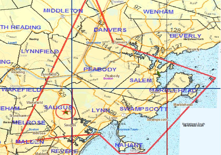
During the GRE scoping session, SAIR park staff suggested that they would draw a boundary
showing the park area of interest to better define the scope of needed large-scale geologic mapping.
Marc Albert (SAIR) has been working with Rudolph Hon (Boston College) on this task. Potentially
a graduate student (potentially funded by the EdMap program) could update existing bedrock
geologic maps of the SAIR area of interest. Marc Albert sent GRE staff this proposed area of study
3for SAIR in an email dated 2007-1109 (figure 2). The area drawn encompasses several 7.5’
quadrangles in the SAIR area including the Marblehead North, Salem, Reading, Marblehead South,
Lynn, and Boston North quadrangles (where SAIR resides). It is still unknown if a map will be
created for this entire extent but at the very minimum it is likely that geologic information would be
provided for the Boston North 7.5’ quadrangle.
Figure 2. Proposed SAIR study area for refined geologic mapping by Boston College encompassing portions of
Marblehead North, Salem, Reading, Marblehead South, Lynn, and Boston North 7.5’ quadrangles.
The USGS is in the process of producing new large-scale digital surficial geologic maps in the area.
Byron Stone and Janet Stone (USGS) are the points of contact for an update on the status of this
new mapping. As of August, 2008, according to the Massachusetts office of the State Geologist, the
USGS surficial coverage is probably one year from publication for the Boston North, Lynn and
Marblehead South quadrangles. Some of these quadrangles are already published in USGS OF-
2006-1260b and available as GIS layers for the Marblehead North, Salem and Reading 7.5’
quadrangles. Joe Kopera (Office of Massachusetts State Geologist) was unsure of release status for
the other quadrangles (Marblehead South, Lynn, and Boston North). For the currently unpublished
quadrangles for the SAIR suggested area, there is published smaller-scale surficial geology
contained in GMAP 74763 (Kaye, C.A., 1978, Surficial geologic map of the Boston area,
Massachusetts, USGS, Open-File Report OF-78-111, 1:100,000 scale). This publication could
supply interim surficial data for the Marblehead South, Lynn and Boston North 7.5’ quadrangles
until the newer USGS maps are released.
Older USGS bedrock maps in the area have never been converted into a digital format to date
(GMAPs 74765 and 2436; Kaye, C.A., 1980, Bedrock geologic maps of the Boston North, Boston
South, and Newton quadrangles, Massachusetts, USGS, Miscellaneous Field Studies Map MF-
1241, 1:24,000 scale), but the Office of the Massachusetts State Geologist has interest in digitizing
the Boston area bedrock geologic map at 1:24,000-scale into a GIS format (Joe Kopera e-mail dated
2008-0626). This publication covers the Boston North, Boston South and Newton 7.5’ quadrangles.
For SAIR, it is likely that only the Boston North 7.5’ quadrangle would be desired from this
publication. However, the other quadrangles might be of utility for BOHA. Additionally, in the
4interim, the Massachusetts State Bedrock Geologic map might also be useful for the areas currently
lacking available large-scale mapping (GMAP 74826; Suzanne W. Nicholson, Connie L. Dicken,
John D. Horton, Michael P. Foose, Julia A.L. Mueller, and Rudi Hon, 2006, Preliminary integrated
geologic map databases for the United States-Connecticut, Maine, Massachusetts, New Hampshire,
New Jersey, Rhode Island, and Vermont, USGS, Open-File Report OF-2006-1272, 1:500000 scale,
http://pubs.usgs.gov/of/2006/1272/)
The Office of the state geologist of Massachusetts has a good website for discerning which data is
already available and in which formats; address is:
http://www.geo.umass.edu/stategeologist/frame_maps.htm
Tables 2 and 3 list the source maps chosen for Minute Man National Historical Park and Saugus
Iron Works National Historic Site and mapping needs in certain quadrangles, in addition to a unique
“GMAP ID” number assigned to each map by GRE staff for data management purposes, map scale,
and action items.
For Saugus Iron Works National Historic Site, GRE staff could use the following maps:
• (2436) Kaye, C.A., 1980, Bedrock geologic maps of the Boston North, Boston South, and
Newton quadrangles, Massachusetts (sheet 1 / 2), , Miscellaneous Field Studies Map MF-
1241, sheet 1 / 2, 1:24000 scale
• (74765) Kaye, C.A., 1980, Bedrock geologic maps of the Boston North, Boston South, and
Newton quadrangles, Massachusetts (sheet 2 / 2), , Miscellaneous Field Studies Map MF-
1241, sheet 2 / 2, 1:24000 scale
• (74763) Kaye, C.A., 1978, Surficial geologic map of the Boston area, Massachusetts, ,
Open-File Report OF-78-111, 1:100000 scale
• (74826) Suzanne W. Nicholson, Connie L. Dicken, John D. Horton, Michael P. Foose, Julia
A.L. Mueller, and Rudi Hon, 2006, Preliminary integrated geologic map databases for the
United States-Connecticut, Maine, Massachusetts, New Hampshire, New Jersey, Rhode
Island, and Vermont, , Open-File Report OF-2006-1272, 1:500000 scale
Additional items of interest pertaining to geologic mapping from the scoping
The parks have some interest in landscape evolution maps, historical interpretation maps, and
mineral resource maps.
5Geologic Resource Management Issues
The scoping session for Minute Man National Historical Park and Saugus Iron Works National
Historic Site provided the opportunity to develop a list of geologic features and processes, which
will be further discussed in the final GRE report. During the meeting, participants prioritized the
most significant geologic issues as follows:
(1) Fluvial issues
(2) Mass wasting
(3) Seismicity
(4) Paleontological resources
(5) Disturbed lands and mineral extraction
Fluvial Issues
The Concord River at Minute Man National Historical Park is prone to flooding. Flooding along
this river seldom extends beyond its natural floodplain. Only low-lying trails and infrastructure are
at risk for damage. Wetland areas flank most local streams. Within the park, the altered, re-
channeled course of Mill Brook is a potential target for restoration to the natural conditions at the
time of the battle. Flooding commonly arises from beaver activity in the area. Beaver dams
impound streams causing local floods and wetlands to develop. Within the park, this flooding
changes farm fields, turning them into wetlands in areas south of Meriam’s Corner. Just outside of
park boundaries, a culvert clogged through subsidence floods local roads including the Cambridge
Turnpike. This engineering structure is under the jurisdiction of the local town government. A
tributary of Elm Creek, Sunnyside Brook is completely diverted into an underground flow system
consisting of buried culverts. The park is currently engaged in removing the underground system to
daylight the stream course through the park. Phase I of this restoration is complete and the park is
starting phase II.
The Saugus River dominates the landscape at Saugus Iron Works National Historic Site. It was a
key transportation link throughout the area’s history. At this point upstream of its mouth, the Saugus
River is tidal with a fluctuation of less than 2 m (6 ft). There are submerged bay head bars at knick
points. At high tide, there is some saltwater intrusion onto the river’s floodplains and lower
structures. This creates a unique brackish estuarine habitat within the riparian zone flanking the river
at the site. Species such as rainbow smelt and American eels flourish there. Structures within the
park are mainly on bluffs and lower floodplain areas. Fluvial issues include riverbank and head-
cutting erosion. In the park vicinity, aggradation added less than 1 m (2 ft) of post-agricultural
sediments to the river floodplain. The park is in the midst of a restoration project that will increase
the local volume of the river and change channel morphology. This project aims to restore the
Terning Basin, which is a cultural wetland landscape. This project will restore old boatways in an
attempt to determine how the iron works originally functioned. In the fall of 2007, the project will
include excavating sediments, connecting the iron works with a dock and introduce replica boats.
At both park units, increased sedimentation occurs in streams near high use areas such as bridges
and trails. Some low-lying features require stabilization and block reinforcement. Disturbed areas
stripped of stabilizing vegetation experience accelerated runoff and erosion, which locally increases
sediment load and changes the channel morphology of the neighboring stream. Trees provide
natural buffers to surrounding urban development and the parks limit tree removal.
6Mass Wasting
The rivers and streams at Minute Man National Historical Park and Saugus Iron Works National
Historic Site cut through rolling hills, terraces, low bluffs, and alluvial fans. Gravity, frost and plant
root wedging, undercutting stream banks, and differential erosion are primary natural causes of
slope instability. As such, hillslope processes such as slumping and slope creep are a resource
management issue at both parks. Trails are eroding locally at Minute Man National Historical Park.
Trails at Saugus Iron Works climb the steeper hill slopes (>45°) and may be prone to mass wasting,
especially when water-saturated. The national historic site plans to pave and chip seal all trails. Trail
construction should avoid areas prone to undercutting.
Any steep slope at the parks poses a mass wasting hazard. Most slopes are vegetated and essentially
stable. Anthropogenic changes to the hill slopes such as road and trail construction, mining,
undercutting, and deforestation are the most common triggers of active sliding. Engineering
structures designed to redirect water and stabilize riverbanks often lead to instability and
reactivation of old slumps.
Seismicity
Neither Minute Man National Historical Park nor Saugus Iron Works National Historic Site is
located near an active seismic zone. Small earthquakes do happen locally, but most of these events
are too minor to be felt at the surface and range between magnitude 2 and 3. Seismic activity locally
focuses on northwest trending faults in the Nashoba Terrane. In 1755, a large earthquake near Cape
Anne was strong enough to ring bells, topple chimneys and weather vanes, and damage stone walls
from Portland Maine to Hartford, Connecticut. Its magnitude was approximately 6.4 on the Richter
scale. If such an event were to occur today, the damage estimates are in the billions of dollars. Large
seismic events may trigger landslides, rockfall and damage park infrastructure. The nearest seismic
station is at the Weston Observatory (http://www.bc.edu/research/westonobservatory/). The U.S.
Geological Survey monitors seismic activity throughout the region. Recent activity is available at
the following earthquake-monitoring website: http://earthquake.usgs.gov/eqcenter/recenteqsus/.
Paleontological Resources
Fossils are an unlikely resource at Minute Man National Historical Park. Pleistocene age fossils are
always possible in glacial deposits. At Saugus Iron Works National Historic Site, marine fossils are
buried in clay layers found north of the park boundary. It is unknown if fossils exist within the park
at this time.
Disturbed Lands and Mineral Extraction
Over the past several centuries at Minute Man National Historical Park, the entire landscape was
subjected to anthropogenic disturbances from early settlement, agriculture, and colonization to later
urbanization until the establishment of the park. The park’s mission is to restore and preserve battle
conditions from the late 1700s. To achieve this, the park removed buildings and businesses such as
car dealerships, hotels, veterinary clinics, and homes and restored them back to meadows, fields,
and forests. The park is in the process of restoring many of the original stonewalls. Rocks for this
project are imported and not excavated from park lands. Adjacent to the park near a modern housing
development was a large sand and gravel quarry excavating glacial outwash deposits that exist
throughout the entire area. Smaller quarries were common in the park area prior to its establishment,
7but are now largely overgrown and of no particular concern to park resource management. Locally,
disturbed areas support thriving poplar groves, gray birch, and sweet fern biotic communities.
At Saugus Iron Works National Historic Site, the area was chosen for the early furnace because of
the abundance of surrounding natural resources. Local clays and gabbro from nearby areas were
extracted from the landscape as raw materials. During the height of iron operations there, the
landscape was extensively disturbed; however, this is part of the historic context that the park
wishes to restore and preserve. The one square mile millpond supplied water for the local mill
impounded by a 15 m (50 ft) high dam one-quarter mile upstream. At the site, encroaching erosion
threatens a historic slag and 17th-century refuse pile. This pile, located near the original loading
dock, is an interpretive target. However, it contains unwanted contaminants that could pollute the
river if eroded. Other disturbed areas include a local road that that once ran through the park, but
was rerouted in the 1940s-50s.
Features and Processes
Aeolian Features
As described below, glacial ice covered eastern Massachusetts during the Pleistocene Epoch. Once
the glacial ice melted and retreated northward, and ensuing glacial lakes such as Glacial Lake
Sudbury and younger Glacial Lake Concord drained from the area, the stark landscape was devoid
of any stabilizing vegetation. The prevailing winds picked up the sand and silt from glacial lake
deposits, transporting them on currents to create sand dunes and blankets of loess deposits. At
Minute Man National Historical Park, surficial mapping revealed ventifacts, or stones shaped, worn,
and polished by the abrasive action of windblown sand. Paleodunes formed after the latest glacial
retreat may exist on the landscape. These would be comprised of sand and silt.
Glacial Landscapes
During the Pleistocene Epoch, more than 10,000 years ago, glacial ice sheets descended from the
north over eastern Massachusetts, covering the landscape. Glaciers are effective agents of erosion,
beveling hills and other topographic highs while transporting vast amounts of sediments picked up
en route. When the glacial ice melts and retreats, these sediments remain and may cover the
underlying landscape. If glacial retreat is rapid, the sediments once entrained in the glacial ice are
relatively unsorted and contain fragments of various sizes ranging from the smallest clay to
boulders. Collectively, these deposits are called glacial till. Outwash streams typically accompany
glacial melting by draining downslope away from the melting ice front. These sediment choked
streams leave sorted channel, delta, and floodplain deposits. A series of glacial lakes (Glacial Lake
Sudbury and Glacial Lake Concord) formed in front of the retreating glacial ice edge. Associated
with these lakes are clay, sand, beach, and shoreline features throughout the area. Thin glacial
deltaic and outwash deposits mantle the bedrock. Deltaic deposits formed by water flowing from
melting glaciers and outwash streams into glacial lakes. These deltas have characteristic
assemblages. The most glacial-distal set are called bottom set beds. Angled foreset beds cover the
bottom sets and top sets cover the entire sequence. As glacial ice pulls further back, the delta
collapses and the whole sequence repeats itself. Locally, stranded deltas more than 60 m (200 ft)
high formed an impoundment for Glacial Lake Concord. This lake had two relatively stable stages
at 56 m (185 ft) deep and 44 m (145 ft) deep.
8Within the boundaries and surrounding areas of Minute Man National Historical Park, glaciers left
chunks of remnant ice that melted to form kettle ponds. Folly Pond within the park is a closed
depression (no inlet or outlet) in a sand plain. Because the surficial morphology of the entire area is
glacially-derived, most of the small natural ponds are kettles. Today, seasonal rain is causing the
ponds to grow laterally, but many are infilling with sediment. Other glacial features in the park
include kame deltas, sand and outwash plains, deltaic divides, drumlins, thick till deposits, glacial
erratics, meltwater channels, and striated bedrock exposures. Glacial features are prominent on the
landscape at Minute Man National Historical Park. For this reason, they strongly influenced the
history of the area from pre-settlement Native Americans to colonists to the start of the
Revolutionary War.
At Saugus Iron Works National Historic Site, the Saugus River incises a relatively flat surface. The
predominant sediment type is clay (Boston blue clay?). In 1646, glacial and marine clays provided
casting materials for pots. This site may represent a flat-topped sandy glacial delta. Higher areas
may have more glacial features. More research on the surficial geology of the area would illuminate
the glacial features present on the landscape.
Type Localities and Other Unique Features
Type localities refer to the originally described sequence of rock that constitutes a geologic unit. It
serves as an objective standard for comparison with spatially separated parts of that same unit.
Preferably, a type section describes an exposure in an area of maximum unit thickness and
completeness. Type localities may also refer to major geologic structures such as regional faults.
Within Minute Man National Historical Park, the Bloody Bluff fault zone is remarkably exposed.
During the construction of Route 2A, blasting exposed a large segment of the fault. Today, a
powerline trends over the fault and routine maintenance removes obscuring vegetation locally. This
intensely deformed zone separates the Avalon and Nashoba terranes. Fault rock types such as
mylonites (rocks squeezed and stretched under high temperature and pressure) and pseudotachylytes
(veins of material melted by friction from sudden movement along a fault surface). Deformation
along this fault zone was in two phases. An earlier more ductile phase created the mylonitic texture
at 10-15 km (6-9 miles) depth in the earth’s crust. Further to the north, this zone is called the
Burlington mylonite zone. Younger, more brittle deformation associated with shallower depths
occurred along the Bloody Bluff fault zone. Movement along this zone was oblique as the Avalon
Terrane to the east subducted beneath and slid northwards past the Nashoba Terrane to the west.
Geology and History Connections
Since 1635, Concord has been a fixture in eastern Massachusetts. This area supported agrarian
pursuits with rich fertile soil and abundant natural resources such as forests and rivers. Deglaciation
processes gave rise to a variety of substrate types throughout the area. The glacial till underlying
much of the flatter areas was a poor substrate for growing barley. Colonists planted apple trees, and
pasturelands dominated instead of tilled fields. Glacial erratics and outwash boulders provided fence
material. Animal grazing was part of this lifestyle and the park is testing potential grazing of the
landscape with the University of Massachusetts, Boston. In 2002-04, 300 sheep grazed test plots on
established meadowlands within park boundaries. These sheep may alleviate some of the ecosystem
strains due to invasive plants.
9The history of the start of the Revolutionary War is deeply connected with the surficial geology and
topography of the Lexington-Concord area. During initial colonial unrest, militia living outside
Boston formed Minute Companies. Colonists began stockpiling scattered arms and Concord, just 26
km (16 miles) from Boston was an ideal location. On April 18, 1775, 4,000 British soldiers under
General Gage marched westward from Boston towards Concord to retrieve stockpiled munitions.
Men such as Paul Revere road horses westward to warn colonists. An initial skirmish at Lexington
Green left eight colonists dead. Later, at the bridge over the Concord River northeast of the town,
the colonists fought back and released the “shot heard ‘round the world” killing British soldiers. At
Meriam’s Corner, the third battle of the day, colonists used the local ridges and topography to shield
their movements and ambush the British as they retreated along Battle Road. This ridge exists
because of deltaic divide deposits left between retreating ice of the Pleistocene Ice Age and Glacial
Lake Concord. Homes flanked this ridge for protection from the northern wind and the road ran
along its southern flank. The road is on a divide between drainages, flanked by boggy swamplands.
Meriam’s Corner forms a point where the deltaic ridge ends, merging with lake bottom sediments of
the flatter surrounding areas. The delta ends abruptly because its sediment source was an
intermittent esker and it did not exist long enough to spread further east.
Following the Meriam’s Corner incident, the colonists continued to plague the retreating British as
far as Boston for 7 hours. The bloodshed to the east of Meriams Corner gave the Bloody Bluff fault
zone its name. Brooks Hill, Fisk Hill, and the bluff all played significant roles in the battle
skirmishes of spring 1775. The park as a cultural landscape wishes to preserve the effects of humans
on the landscape insomuch as they reflect historically significant events. The park wishes to
preserve the first 6 km (4 miles) of Battle Road.
The Saugus River area has long been a focal point for settlement and natural resource use. During
the Paleo-Indian Period (12,000-9,000 years before present) Native Americans quarried Saugus
“jasper” in several quarries some less than 1 km (0.5 miles) downstream from the national historic
site. This reddish, buff colored stone had the favored ability to be worked into projectile points and
tools. Native American artifacts may be present in the sediments at the site flanking the river. These
were covered by sediments settled behind the dam and redistributed by high flows stemming from
an early breach of the dam. During restoration, the park will attempt to avoid exposing these
artifacts.
The area was chosen by early settlers to develop an iron mill because of the natural resources in the
surrounding areas (bog iron ore, gabbro, and timber for charcoal) as well as its proximity to a
coastal transportation port. A low-grade fall line occurs just upstream from the iron works. Barges
could travel up the Saugus River to the mill carrying raw materials and return downstream with
manufactured products from the iron works. The furnace was in operation for approximately 20
years. Its closure was a market driven issue.
Excavation at the national historic site is ongoing. In the 1940s, excavations to find the original
foundation of the iron works necessitated rerouting Central Street in Saugus, Massachusetts. This
excavation exhumed thousands of artifacts from the riverine sediments including remnants of the
waterwheel. Other historic features at the site include the Wallace Nutting House. Preserving
cultural features and landscapes often means resisting natural geologic processes such as
weathering, erosion, flooding, and settling.
10The park wishes to determine the exact source, type, and properties of the clay used at the iron
furnace. This clay provided molds for iron products. Other materials necessary for flux and smelting
including ultramafic gabbro (low silica - high calcium and magnesium) and limestone (?) were
locally derived, but the exact locations, compositions, and properties of these materials remain
unclear. Gabbro may have come from the Nahant Peninsula to the southeast of Saugus River. The
park also wants to know the source area for the rocks comprising the furnaces and outbuildings.
Recommendations
(1) Consider tapping the Geoscientists-in-the Parks program to perform research and field study to
determine the source materials used at SAIR.
(2) Use the Massachusetts State Geologist website for general geologic information:
http://www.geo.umass.edu/stategeologist/index.html
(3) Study sedimentation patterns and distribution along river corridors noting areas of sediment loss
and gain.
(4) Increase awareness of and monitor seismic activity through the websites managed by the U.S.
Geological Survey and Weston Observatory (Boston College).
(5) Promote research into the overall tectonic history of the region as timing relationships between
the Avalon Terrane and Nashoba Terrane remain unclear.
(6) At SAIR, gather baseline information and monitor water and soil quality around old refuse pile
to determine if surrounding resources are being contaminated.
(7) Interpret the geologic map for both park units for visitors focusing on geologic resources,
geologic history, and connections between geology, biology, evolution of the landscape and historic
events.
Action Items
(1) GRE staff will reference Massachusetts Geological Survey website for information
http://www.geo.umass.edu/stategeologist/index.html
(2) GRE will produce digital geologic map for Minute Man National Historical Park and Saugus
Iron Works National Historic Site including surficial and bedrock coverage (see above geologic
mapping section).
(3) GRE will consider funding for graduate student work in the Lexington Green area and SAIR’s
defined area of interest.
(4) GRE report author will obtain a copy of C. Langford’s Masters thesis (Fall 2007) from Boston
College covering the geology of the Concord quadrangle.
(5) GRE report author will obtain Kaye (1978) Surficial geologic map of the Boston Area,
Massachusetts. U.S. Geological Survey, Open-File Report 78-111.
(6) GRE report author will obtain Kaye (1976) The Geology and Early History of the Boston Area
of Massachusetts, a Bicentennial Approach. U.S. Geological Survey Bulletin 1476
References
www.nps.gov/mima (accessed July 30, 2007)
www.nps.gov/sair (accessed July 30, 2007)
www.topozone.com (accessed July 30, 2007)
11http://www.reverebeach.com/rumneymarsh/4directions.html (accessed July 31, 2007)
http://www.masshist.org/objects/2005november.cfm (accessed July 31, 2007)
Barosh, P.J.; Sideris, L. 2006. Concord-Lexington: The Influence of Plate Tectonics and a
Pleistocene Lake and Flood on the Battle of April 19, 1775. In Field Trips in Eastern Massachusetts
and Adjacent Rhode Island for Association of Environmental & Engineering Geologists 49th Annual
Meeting, Boston, MA. Barosh, P.J., ed.
12Table 1. Scoping Meeting Participants
Name Affiliation Position Phone E-Mail
Albert, Marc NPS-SAIR/BOHA Natural Resource 978-360-0421 Marc_albert@nps.gov
Specialist
Connors, Tim NPS – GRD Geologist 303-969-2093 Tim_Connors@nps.gov
Heise, Bruce NPS – GRD Geologist 303-969-2017 Bruce_heise@nps.gov
Hepburn, Chris Boston College Geologist 617-552-3642 Hepburn@bc.edu
Kopera, Joe University of Geologist 413-320-2435 jkopera@geo.umass.edu
Massachusetts, Amherst
Mabee, Steve University of State Geologist 413-545-4814 sbmabee@geo.umass.edu
Massachusetts, Amherst
Mitchell, Brian NPS-NETN Network Coordinator 802-457-3368, Brian_r_mitchell@nps.gov
ext. 37
Siderusm Lou NPS – MIMA Planning Chief 978-318-7833 Lou_sideris@nps.gov
Thompson, Wellesley College Geologist 781-283-3029 mthompson@wellesley.edu
Meg
Thornberry- Colorado State University Geologist-Report Writer 757-416-5928 tthorn@cnr.colostate.edu
Ehrlich, Trista
Wall, Suzanne Andover Geologic Geologist 978-688-3654 andovergeologic@comcast.net
Consulting
Wise, Don University of Geologist 413-253-5342 dwise@geo.umass.edu
Massachusetts, Amherst
13Table 2. GRE Mapping Plan for Minute Man National Historical Park
1
Covered GMAP ID Reference GRE appraisal GRE Action Scale
Quadrangles
2008-0731: need update from Boston College on this map and if it exists and
C. Langford and C. Hepburn, 2007, Bedrock is available for MIMA; would give GRE large-scale bedrock for MIMA to
geologic map of the Concord quadrangle, accompany large-scale surficial from GMAP 74750. hoping it will be digital
Concord, MA 74982 Conversion 24000
unpublished, Master’s thesis, Boston and GIS based. Awating final response from Chris Hepburn (Boston
College, 1:24,000 scale College). OMSG is willing to expedite review of map and publish as open file
report.
Stone, J.R. and Stone, B.D., 2007, Surficial
geologic map of the Clinton-Concord- 2008-0731: covers multiple 7.5' quads, but also does cover MIMA qoi for
Grafton-Medfield 12-quadrangle area in east Concord 7.5'; is digital gis based; should use. Should likely supercede
Concord, MA 74750 central Massachusetts, U.S. Geological GMAP 8096. can accompany GMAP 74982 (Concord 7.5' bedrock), map Conversion 24000
Survey, Open-File Report OF-2006-1260-A can accompany GMAP 74982. Note: glaciofluvial units are lumped on this
map and explained in accompanying text.
http://pubs.usgs.gov/of/2006/1260/A/
14Table 3. GRE Mapping Plan for Saugus Iron Works National Historic Site
1
Covered GMAP Reference GRE appraisal GRE Action Scale
Quadrangles ID
Kaye, C.A., 1980, Bedrock geologic maps of the
2008-0702: for SAIR useful for bedrock geology of single Boston North QOI;
Boston North, Boston South, and Newton
not known to be digital; sheet 1 (GMAP 2436) gives bedrock polygons; sheet Maps need digitized
Boston North 74765 quadrangles, Massachusetts (sheet 2 / 2), , 24000
2 (GMAP 74765) gives tunnel engineering information. Massachusetts GS (GRE or OMSG ?)
Miscellaneous Field Studies Map MF-1241, sheet 2 /
wants to digitize this map, but needs funding support
2, 1:24000 scale
Stone, B.D., Stone, J.R., and DiGiacomo-Cohen,
2008-0731: this is in SAIR area of interest to yield 3 7.5' quads for
Marblehead North M.L., 2007, Surficial geologic map of the Salem
Marblehead North, Salem, and Reading surficial geology; may convert these.
Salem 74751 Depot - Newburyport East - Wilmington - Rockport Conversion 24000
Per OMSG, all 3 quads are in GIS format with metadata, found in OF 2006-
Reading 16-quadrangle area in northeast Massachusetts, ,
1260B. Units are consistent and edge-matched.
Open-File Report OF-2006-1260-B, 1:24000 scale
Kaye, C.A., 1980, Bedrock geologic maps of the 2008-0731: for SAIR useful for bedrock geology of single Boston North QOI;
Boston North, Boston South, and Newton not known to be digital; sheet 1 (GMAP 2436) gives bedrock polygons; sheet
Maps need digitized
Boston North 2436 quadrangles, Massachusetts (sheet 1 / 2), , 2 (GMAP 74765) gives tunnel engineering information. Massachusetts GS 24000
(GRE or OMSG ?)
Miscellaneous Field Studies Map MF-1241, sheet 1 / wants to digitize this map, but needs funding support. Per OMSG, MF 1241 is
2, 1:24000 scale not GIS ready and needs integrated data from Bailey at Northeastern Univ.
Kaye, C.A., 1978, Surficial geologic map of the
Await newer digital
Multiple 74763 Boston area, Massachusetts, , Open-File Report 2007-0703: likely supercedes GMAP 74764; not known to be digital 100000
maps; no action
OF-78-111, 1:100000 scale
Suzanne W. Nicholson, Connie L. Dicken, John D.
Horton, Michael P. Foose, Julia A.L. Mueller, and
Rudi Hon, 2006, Preliminary integrated geologic
2008-0702: might use for interim SAIR bedrock for extra areas of interest not Await newer digital
Multiple 74826 map databases for the United States-Connecticut, 500000
covered by larger scale pubs. maps; no action
Maine, Massachusetts, New Hampshire, New
Jersey, Rhode Island, and Vermont, , Open-File
Report OF-2006-1272, 1:500000 scale
15You can also read