Geology of the Eminescu (H-09) quadrangle: Mapping status
←
→
Page content transcription
If your browser does not render page correctly, please read the page content below
Geology of the Eminescu (H-09) quadrangle: Mapping status
                Mayssa El Yazidi1, Gloria Tognon1, Valentina Galluzzi3, Lorenza Giacomini3 & Matteo Massironi1,2

1Centro  di Ateneo di Studi e Attività Spaziali "Giuseppe Colombo" - CISAS, Via Venezia 15, 35131 Padova, Italy,
2Dipartimento di Geoscienze, Università degli Studi di Padova, via Gradenigo 6, 35131 Padova, Italy.
3 INAF, Istituto di Astrofisica e Planetologia Spaziali (IAPS), Via del Fosso del Cavaliere, 100, 00133 Roma, Italy.

  ABSTRACT:

  A geological mapping coordinated project (Galluzzi et al. (2021)) aims to deliver geological maps for Mercury's quadrangles by using
  NASA/MDIS datasets. In this context, we are presenting the geological mapping status of Eminescu (H-09) quadrangle that covers the
  area between latitudes 22.5°N, -22.5°S and longitudes 72°E, 144°E. The mapping is being produced on 166m/px monochrome
  basemaps and a 3-color basemap with a resolution of 665m/px. The preliminary analysis of the quadrangle shows intriguing
  morphology related to endogenic and exogenic processes, where intense compressive tectonic and cratering structures are the
  fundamental geological events that cause the heterogeneity of the terrains. Through the mapping of Eminescu (H-09), we will deliver
  the first geological map for this quadrangle with a 1:3M output scale. Once the mapping is completed, we will be able to set up the
  geologic and morphological context of the quadrangle and target all the interesting features in the frame to support ESA/JAXA
  BepiColombo mission.

                                                                                                                                         1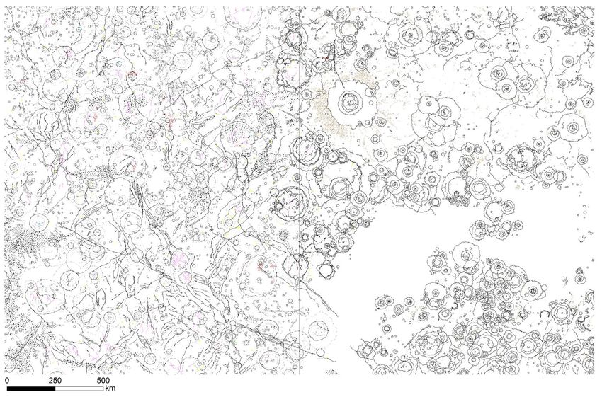
1.Introduction

 1:3M Geological Maps of Mercury: Project Team
  PLANMAP and mission-level coordination        SIMBIO-SYS supervision           Targeting and technical support
  David A. Rothery                              Gabriele Cremonese               Cristian Carli (spectral mapping supervisor)
  Matteo Massironi                              Fabrizio Capaccioni              Nicolas Bott
  Geological mappers                            Alain Doressoundiram             Francesca Zambon
  Valentina Galluzzi (maps supervisor)
                                                Pasquale Palumbo
  Lorenza Giacomini
  Laura Guzzetta
  Anja Lentz
  Alexander Lewang
  Chris Malliband                                                                                                           Completed & published
  Paolo Mancinelli
  David Pegg                                                                                                                Completed
  Felix Prüße                                                                                                               In progress
  Andrea Semenzato                                                                                                          Scheduled
  Gloria Tognon
  Jack Wright                                                                                                               Not scheduled
  Mayssa El Yazidi
  Luigi Ferranti
  Harald Hiesinger
  Cristina Pauselli
  Color/compositional maps
  Cristina Re                       Fig.1. Status of the European coordinated quadrangle mapping of Mercury
  Michele Zusi                                                 (Galluzzi et al. (2021))
13 - 24 September 2021                                    Europlanet Science Congress 2021                                                     2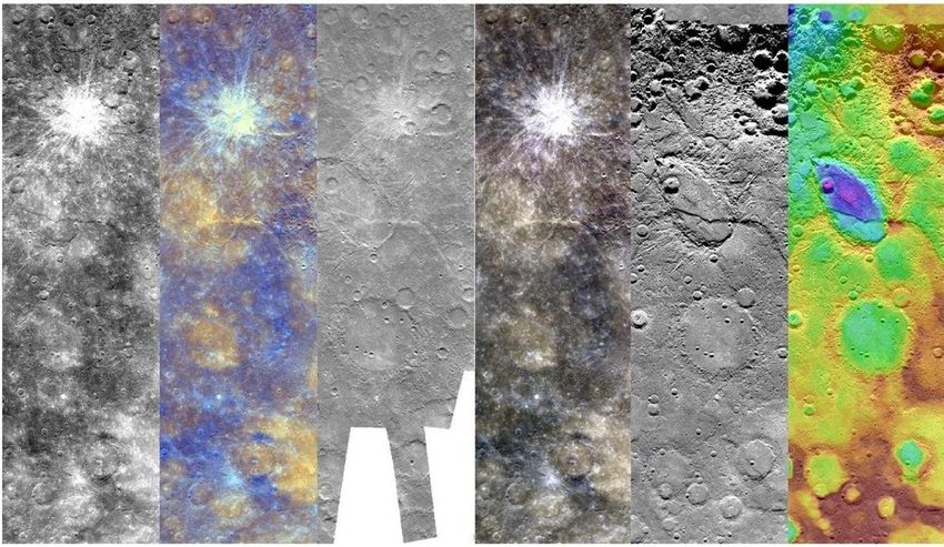
2.Methodology
Data Scale and Symbology
As a basemaps, we used the following available data Output Scale: 1:3M
derived from the MESSENGER Mercury Dual Imaging Mapping scale: 1:400K
Systems (MDIS): Symbology:
- Monochrome mosaic Basemap Reduced Data Record (BDR, ~166 Based on the Federal Geographic Data Committe (FGDC) and
m/px) United States Geographic System (USGS) recommendations
Monochrome mosaics with different incidence angles and illumination with appropriate revisions.
conditions (LOI, HIE and HIW, ~166 m/px) Linear features
Legend: Surface
- Enhanced-color global mosaic (665 m/px) structures
- RGB-color global mosaics (665 m/px) Geological units features
- For the Topography, we used USGS Global DEM (665m)
Geological contact Linear features
Point features morphology
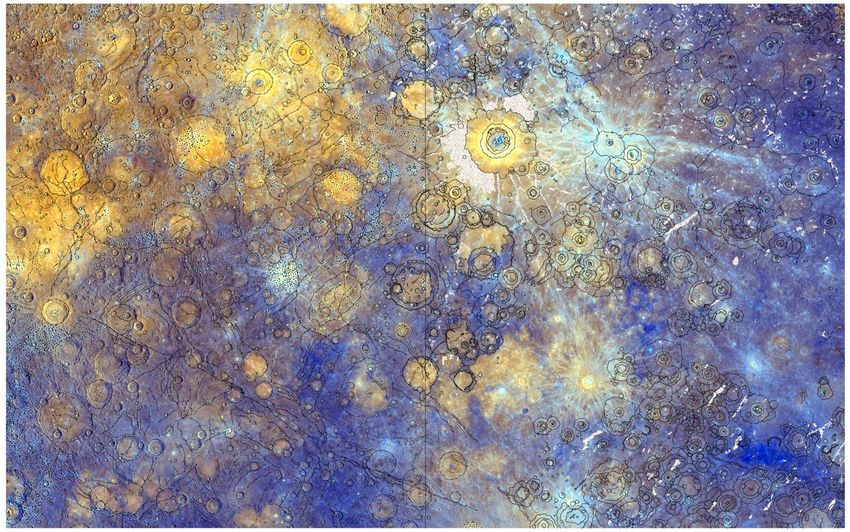
Fig.2. Various basemaps used for Eminescu mapping.
13 - 24 September 2021 Europlanet Science Congress 2021 3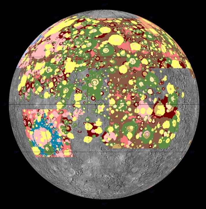
3.Results
 Coordinates:                     Projection System:
 72°E - 144°E, 22,5°N - 22,5°S    Equirectangular

 The mapping of the Eminescu quadrangle
 (Fig.3) will help to raise the global mapping
 status of Mercury, and by the current work, we
 are reaching up to approximately 50% of the
 surface of Mercury, with a 1:3M output scale.

 We were able to carry out a target list (Fig.4)
 with 38 interesting features on the area,
 varying between structures and volcanic
 features, hollows, terrains, and craters, for
 future study and exploration by the SIMBIO-SYS
 instrument onboard the BepiColombo mission.

                                                                                                               75%

                                                                                                                     Progress
    Fig.4. Examples of some selected targets
                                                                    Fig.3. Mapping status of Eminescu (H-09)
13 - 24 September 2021                                 Europlanet Science Congress 2021                                  4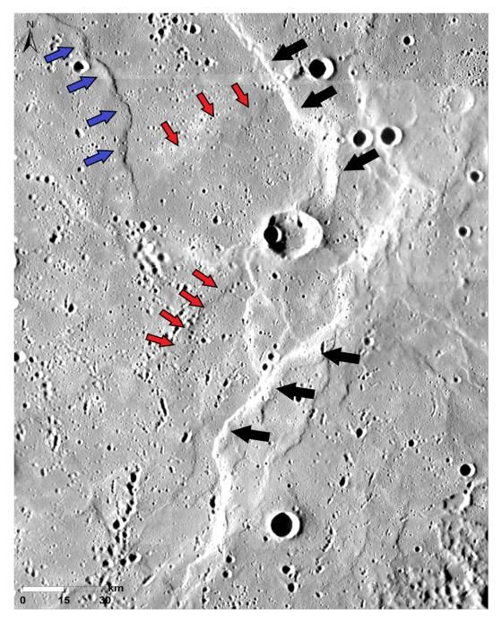
3.Results
 Main Geological processes
 The surface geomorphology of Eminescu quadrangle, shows that the
 craters and faults are the main features that dominate the area
 (Fig.5). The Fig.6 shows evidence of two stages of compressive
 deformation by two distinct sets of tectonic structures following
 NE–SW and NW–SE directions. The elongated form of Beagle Rupes
 (Fig.7), indicates, apparently that this crater is formed by an oblique   Fig.5. View of part of densely
 impact, and crossed afterward by various faults, which generate the       cratered and tectonized terrain in
 formation of a complex zone.                                              the southern part. Image centered
 The Eminescu crater is one of the interesting features in this            at 94.36°E, -10.14°N
 quadrangle, since it is relatively young and it's characterized by
 extensive ejecta for one radius from the crater's rim and a recently
 hollowed central peak (Fig.8.).
                                                                                                                Fig.6.Low relief ridges (red
                                Fig.8. Eminescu crater. Image                                                   arrows) crossed by a wrinkle
                                between 12.3°N, 8.8°N lat                                                       ridge (blue arrows) and by
                                and 115.9°E, 112.2°E lon                                                        the large lobate scarps
                                                                                                                (black    arrows).    Image
                                                                                                                centered at 4.77°N, 1.61°N
                                         Fig.7.Beagle Rupes, cross-cut by main
                                                                                                                Lat and 78.77°E, 77.91°E Lon
                                         faults, generate the creation of
                                         complex feature. Image at 100.91°E, -
                                         2.36°N
13 - 24 September 2021                                     Europlanet Science Congress 2021                                                    5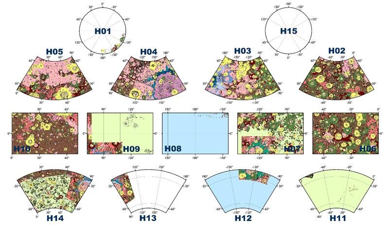
Discussion and Conclusion
    The selection of Eminescu quadrangle among the scheduled quadrangles to be mapped was
    based on its wealth of many interesting features and on the color variation between the
    different terrain types. Almost 75% of the quadrangle was mapped and the initial analysis of this
    quadrangle shows two major processes that shape the surface : A compressive tectonism and
    intensive cratering.

     Future work
     Beagle Rupes, Eminescu crater, hollow deposits and pyroclastic deposits at the margin of the
     Caloris basin are all interesting targets to study and explore. These features and their enhanced
     color variability will probably require a higher-resolution study by integrating the
     geomorphological map with spectral data. Once the 1:3M geological map for Eminescu (H-09) is
     completed, we will deliver Morpho-stratigraphic and Chrono-stratigraphic maps and complete
     the surface analysis to understand the geomorphology of the quadrangle and also contribute to
     the understanding and the exploration of the planet Mercury.

    Acknowledgements
    This research has been supported by European Union’s Horizon 2020 under grant
    agreement N° 776276-PLANMAP.

     References
     Galluzzi et al. (2021), PGM Meeting 2021, LPI Contrib. No. 2610.
                                                                                                         © V.Galluzzi
13 - 24 September 2021                                     Europlanet Science Congress 2021                       6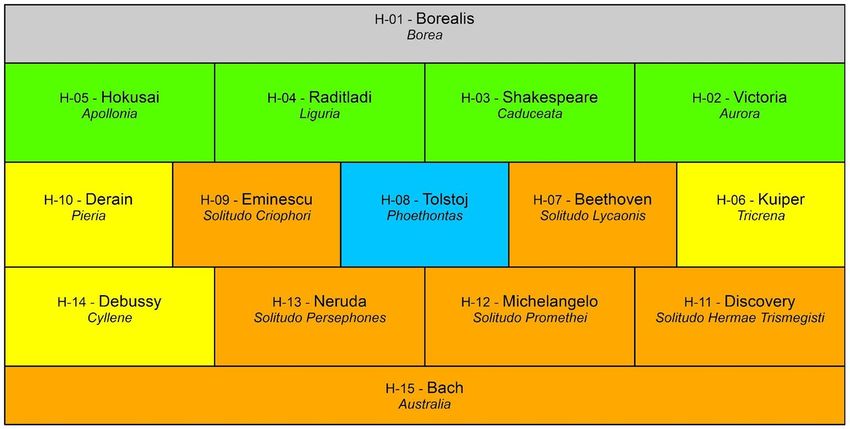


You can also read