GEOLOGY OF THE OTTAWA AREA - OTTAWA-GATINEAU GEOHERITAGE PROJECT FIELD TRIP COMPILED BY QUENTIN GALL November 2010
←
→
Page content transcription
If your browser does not render page correctly, please read the page content below
GEOLOGY OF THE OTTAWA AREA

OTTAWA-GATINEAU GEOHERITAGE PROJECT

             FIELD TRIP

      COMPILED BY QUENTIN GALL
            November 2010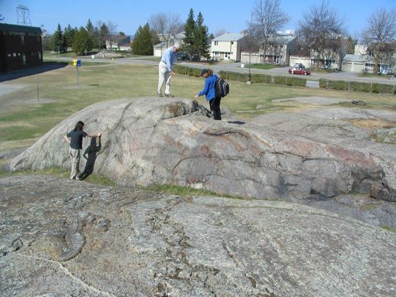
OTTAWA-GATINEAU GEOHERITAGE PROJECT

                                      FIELD TRIP

                     GEOLOGY OF THE OTTAWA AREA

INTRODUCTION

        The Ottawa area contains many interesting exposures of rock that are of great
interest to geologists and non-geologists alike. These rocks are dominated by Paleozoic-
age sedimentary strata that overlie older Precambrian-age rocks which are extensively
exposed in the Gatineau Hills to the north of Ottawa. Although developed over many
millions of years, the rocks in the Ottawa area record only a small fraction of geological
history.

       This field trip takes participants to rock exposures in the Ottawa area that show
geologic features typical of the local Precambrian and Paleozoic rocks. As the field trip
progresses, it attempts to work through the local stratigraphic succession; that is, it starts
with the oldest Precambrian rocks and progresses to the younger, overlying Paleozoic
rocks units. You are encouraged to contact the Ottawa-Gatineau Geoheritage Committee
(OGGC) in the future about this field trip, Geoheritage in the Ottawa-Gatineau region or
any other related scientific question.

       For the sake of protecting the rock outcrops that will be visited on this field trip,
thereby protecting Geoheritage in the Ottawa-Gatineau region, participants are asked not
to mark, scratch or remove even loose pieces from the outcrops (using hammers etc.).
We ask that you observe and preserve your memories through notes and photographs.

GEOLOGIC OVERVIEW

        As shown by the accompanying tables, rocks of the Ottawa area represent the
middle Proterozoic Eon and the early Paleozoic Era, with older Proterozoic and Archean,
and younger Paleozoic, Mesozoic and Tertiary rocks missing. The next youngest
geologic unit stratigraphically overlying the early Paleozoic sedimentary rocks in the
Ottawa area, are unconsolidated sediments which were deposited in the Pleistocene,
during the last stage of the Ice Age and subsequent incursion of the Champlain Sea, about
12,000 to 10,000 years ago. The time gap in the rock record (missing geology)
represented by the unconformity between the early Paleozoic rocks and Pleistocene is
roughly 438 million years. The following paragraphs offer an overview of the geology in
the Ottawa area.
ERA                AGE (Ma)     PERIOD
                                         (start)
                                           .01                      Holocene Epoch
                                                    Quaternary
                  Cenozoic                 1.6                      Pleistocene Epoch
                                          56.4      Tertiary
                                           144      Cretaceous
                  Mesozoic                 208      Jurassic
                                           245      Triassic
                                           286      Permian
                                           360      Carboniferous
                                           408      Devonian
                  Paleozoic                438      Silurian
                                           505      Ordovician
                                           570      Cambrian
                                          2500                 Proterozoic Eon
                 Precambrian              4500                  Archean Eon

                                                   AGE
   ERA                 PERIOD EPOCH (Ma)                         GROUP           FORMATION
                                                   (start)
                                                                                      Queenston
                                                                                       Carlsbad
                                                                                        Billings
                                                                                    Eastview (Mbr.)
                                                                                        Lindsay
                                          Late      458                                   Hull
                          Ordovician

                                                                 Ottawa              Bobcaygeon
     Paleozoic

                                                                                      Chaumont
                                                                                       Lowville
                                                                                        Pamelia
                                                                                      Hog’s Back
                                        Middle      478                               Rockcliffe
                                                                                        Carillon
                                                             Beekmantown             Beauharnois
                                         Early      505                                  March
                                                                                        Nepean
                                                                 Potsdam
                      Cambrian            Late      523                                 Covey Hill
Precambrian           Proterozoic
                                        Middle     1600               Grenville Province
                         Eon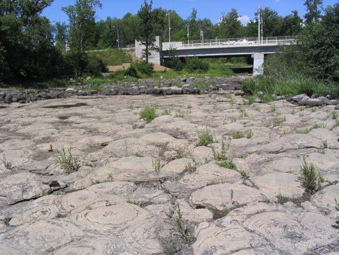
Precambrian Geology
          The oldest rocks in the Ottawa area are part of the Precambrian Canadian Shield
referred to as the Grenville Province. The Grenville Province is subdivided into distinct
belts of geology within tectonic terranes, with the local Precambrian being part of the
metamorphosed and deformed sedimentary, volcanic and plutonic package of rocks
known as the Central Metasedimentary Belt and Frontenac Terrane. Locally, the
Precambrian rocks crop out in the Gatineau Hills north of Ottawa and the northwest-
trending Eardly fault, and in the Carp ridge west of Ottawa (Kanata through Carp to
Arnprior) and north of, and parallel to, the northwest-trending Hazeldean fault.

        The Precambrian rocks include deformed metamorphosed gneiss and marble, of
sedimentary origin, and intrusive plutonic rocks such as diorite, gabbro, syenite and
granite. These Precambrian rocks were part of an ancient mountain belt that formed
during the Middle Proterozoic (ca. 1600 Ma to 900 Ma). The youngest age determination
in the local Precambrian rocks is ca. 950 Ma for diabase intrusions that are part of the
Grenville dyke swarm. Millions of years of erosion and weathering wore down the
ancient mountain belt. Today, Precambrian rocks are exposed in elevated areas, largely
due to uplift along the Hazeldean and Earldy faults, possibly during the Mesozoic.

        Relatively flat lying and unmetamorphosed Paleozoic Era sedimentary rocks
overlie the deformed and metamorphosed Precambrian rocks. Separating the
Precambrian and Paleozoic rocks is an unconformity developed during erosion and
subaerial weathering of the Precambrian rocks, over hundreds-of-millions of years, prior
to deposition of the sediments during the Paleozoic. The weathering of the Precambrian
rocks lead to the development of a paleosol (ancient soil). Pervasive erosion of the
Precambrian rocks also eroded the paleosol so that its preservation is rare. Perhaps the
best local exposure of the paleosol is in Parc de la Lac Beauchamp, Gatineau, where it is
developed on Precambrian metamorphic rocks and buried by basal Paleozoic sandstone
(Nepean Fm.).

Paleozoic Geology
         The succession of Cambrian to Ordovician age sedimentary rocks in the Ottawa
area, consists of sandstone, limestone, dolostone and shale units deposited in terrestrial to
shallow marine environments associated with a widespread epeiric sea that transgressed
the margins of the Precambrian Canadian Shield during the early Paleozoic. Locally, this
site of sediment deposition is referred to as the Ottawa Embayment or the Ottawa-St.
Lawrence Lowlands. Through correlation with similar sedimentary rocks in the
northeastern United States and Ontario, and age-specific fossils in the limestone units, the
Paleozoic rocks in the Ottawa area range from late Cambrian to late Ordovician in age
(ca. 523 Ma to 438 Ma). A cumulative stratigraphic thickness for all Paleozoic
sedimentary rocks in the Ottawa Embayment is about 300 metres.

       The name and age of the different sedimentary rock units in the Ottawa area are
shown in the table. In ascending order, the basal conglomerate-sandstone of the Covey
Hill Formation (Fm.) underlie the quartz-rich sandstone and minor conglomerates of the
Nepean Fm., deposited in marginal marine, fluvial and aeolian environments and
containing trace fossils including evidence of the earliest land-based animal activity
(arthropod). These sedimentary units are overlain by more fossiliferous shallow marine
strata, beginning with the mixed sandstone-dolostone of the March Fm. and then
dolostone-limestone of the Beauharnois and Carillon formations. In turn, these are
overlain by mixed sandstone-shale of the Rockcliffe Fm., then shale, sandstone, impure
limestone and dolostone of the Hogs Back Fm. Stratigraphically higher are the
dominantly limestone formations of the Ottawa Group, starting with the stromatolitic
limestone of the Pamelia Fm. Overlying the Ottawa Group, are the shale-rich Billings
Fm., sand-shale Carlsbad Fm. and, finally, the uppermost red shale of the Queenston Fm.

        The next geologic event in the Ottawa area is the development of west-east and
northwest-southeast oriented normal faults which dissect, and locally warp, the late
Precambrian and early Paleozoic rocks (e.g., Gloucester, Hazeldean and Eardly faults).
These faults, and others along the Ottawa Embayment, are considered to be part of the
extensive, northwest-trending Ottawa-Bonnechere Graben. These local faults are in the
same orientation as the Ottawa Embayment (subbasin), and it has been speculated that the
faults are reactivated Precambrian-age faults that controlled the shape of the early
Paleozoic depositional subbasin in the Ottawa area. It has also been suggested that the
faulting occurred during the Cretaceous Period (late Mesozoic Era), as a few, small
Cretaceous-age alkalic intrusions and dykes in the Ottawa area are similar to the
Cretaceous-age Monteregion Hills near Montreal. These alkalic intrusions and dykes
may be associated with the initial rifting and formation of the Atlantic Ocean.

Quaternary Geology
         The youngest deposits in the Ottawa area are unconsolidated sediments of the
Quaternary Period. The lowermost sequence of sediments consists of clay-rich glacial
till, deposited during the late Wisconsin ice advance and retreat (ca. 12.8 ka to 10.2 ka) of
the Pleistocene Epoch. Stratified sand and coarse gravel that blanket much of the Ottawa
area were produced in a glaviofluvial environment. Finer sediment was deposited in
proglacial lakes. During glacier retreat, while the land was isostatically depressed, there
was a marine incursion into the region by the Champlain Sea. Fine marine sediment,
such as the ca. 70 metre-thick Leda Clay, was deposited in the Champlain Sea, before the
land rebounded and the sea retreated to the east. As the front of the ice sheet continued to
retreat northward, large volumes of Holocene Epoch meltwater drained into the Ottawa
area via the Ottawa Valley and Gatineau River valley. River channels cut into the older
till and marine deposits and, after some channel reestablishment and terrace and bog
formation (e.g., Mer Bleue bog), the reduced present course of the Ottawa River
stabilized and soils, beneficial for agriculture, developed.
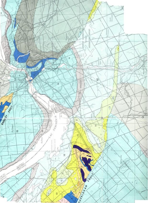
Geology
   Legend
       Q
 Quaternary

Ordovician
        18
Carlsbad Fm.
        17
 Billings Fm.
      14 – 16
Ottawa Gp.
        13
Hog’s Back &
Rockcliffe fms.
        12
Carillon &
Beauharnois
fms.
        11
March Fm.
        10
Nepean Fm.                           Geology of the Ottawa
                  1 to 7 = Stops
                                             Area
      1-9                 N         Geological Survey of Canada
Precambrian                         Map 1508A
rocks                     ↑         By G. MacDonald
                                    Modified by J.E. Harrison
~~~~ Fault        Scale ~.5cm=1km   1980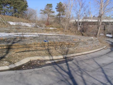
FIELD TRIP STOPS

        Drive west on the Queensway (Hwy. 417) and take March Rd. exit to Kanata. At
the lights, continue straight through on Campeau Dr. then turn right onto Teron Rd.
Proceed to the intersection with Beaverbrook Rd. and turn left. Then turn right off
Beaverbrook Rd. onto Varley Dr. Follow Varley Dr., just past Georges Vanier Catholic
School, to W. Erskine Johnston Public School on the left. Park near the playground at
the back of the school. If the school is open, you should go to the main office and confirm
permission to look at the Stop 1 outcrops.

Stop 1. Precambrian gneiss

         Several glacially scoured outcrops of Precambrian gneiss (metamorphic rock) are
exposed just beside the school’s temporary classroom buildings. The Precambrian gneiss
belongs to the Grenville Province of the Canadian Shield, is over 1 billion years old, and
represents the oldest exposed rocks in the Ottawa area (often referred to as “basement’
rocks” to the younger Paleozoic rock and Quaternary sediment, which have been eroded
from this particular area). Glacial erosion of these outcrops has shaped them into roches
moutonnées, the classic shapes of which indicate southward movement of the Pleistocene
ice at this locality.

       The coarse-grained gneiss displays a metamorphic layering (foliation) along
which the minerals are aligned. Gneiss mineralogy includes quartz, feldspar, mica,
hornblende and garnet. The foliation has been folded during deformation of the gneiss,
which has also caused some minerals to recrystallize and grow parallel to the fold axes (=
mineral lineation). Also evident in the outcrops, are coarse-grained pegmatite dykes of
igneous origin (mainly granite, consisting of quartz and alkali feldspar), which cut across
the gneissic foliation. These cross-cutting, intruding relationships indicate that the dykes
formed after deformation of the gneiss. There are also a few dykes of aplite (finer-
grained crystalline granite) and diorite composition (more mafic minerals).

                              Precambrian gneiss outcrops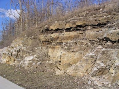
From the school turn left onto Varley Dr. and go to the T-junction at Beaverbrook
Rd. Turn right, proceed to Weslock Way, and turn left (south) onto Knudson Dr. At the
intersection with Campeau Dr., turn right and drive along to the intersection with Kanata
Rd. Turn left onto Kanata Rd., until you meet Earl Grey Dr on your right, and park in
the parking area at this intersection. The next outcrops to look at are behind the Wal-
Mart store.

Stop 2. Nepean Fm. and March Fm. contact

        The outcrops behind Wal-Mart and beside Kanata Dr. provide a vertical section of
the upper part of the Nepean Formation (below) passing into the basal part of the
overlying March Formation (top of outcrops). The few metres of vertical section at this
stop record thousands of years of sand deposition during the early Ordovician, which was
followed by burial and subsequent lithification. In the section behind Wal-Mart, the
quartz-rich sandstone of the Nepean Fm. displays abundant cross beds formed by the
migration of subaqueous dunes during sand deposition. Joints in the section provide a
three-dimensional view of some of the cross beds, making it possible to determine the
paleocurrent flow direction. Several joint faces are covered with oxidized crystals of
marcasite / pyrite. At the top of the lower section, some ripple marks can be seen, and a
few, millimetre-scale circular depressions interpreted as ancient rainprint marks.

       In the upper section, on the east side of Kanata Dr., the outcrop starts to display
dolomitic carbonate beds as well as quartz-rich sandstone beds. This is the transition into
the March Fm. that overlies the Nepean Fm. In the upper section, ripple marks, cross
bedding, dewatering structures, and fossils fragments in the more dolomitic beds can be
seen. The sedimentary bedding dips towards the road, away from the local Precambrian
‘basement’.

Nepean Fm. sandstone behind Wal-Mart store Nepean Fm. to overlying March Fm. transition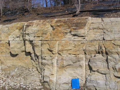
Drive to Terry Fox Dr. on the west side of the Centrum Shopping Centre. Turn
left (south) onto Terry Fox Dr. and drive over the Queensway to Hazeldean Rd. where
you turn left (east). Proceed on Hazeldean Rd., pass across the intersection with
Eagleson Rd. (where Hazeldean Rd. becomes Robertson Rd.), into Bells Corners and turn
right (south) at the intersection with Moodie Dr. Drive south on Moodie Dr. The road
curves right, and becomes Richmond Rd. Continue south on Richmond Rd. past the T-
junction with West Hunt Club Rd. Approximately 1 km past the West Hunt Club Rd. T-
junction, turn right into parking area (blue P6 sign) for the Stony Swamp Conservation
Area. From the parking area, walk along the footpath and boardwalk to a large
exposure of white bedrock.

Stop 3. Nepean Fm.

        This large exposure offers an extensive bedding plane view of the quartz-rich
sandstone typical of the Nepean Fm. The sandstone beds are still in their original,
horizontal position. The sandstone is composed almost entirely of well-sorted sand-size
quartz grains that are cemented by quartz cement. There are abundant sets of trough
cross bedding, from which the paleocurrent direction can be determined (troughs open
down-current to the south). Occasional sets of ripple marks show trends essentially
perpendicular to the paleocurrent flow direction. The sand was likely deposited in a
braided river environment, approximately 500 million years ago. However, the presence
of a few elongate crystal pseudomorphs in the sandstone that are interpreted to have been
gypsum (hydrated calcium-sulphate), suggests that the environment may have had a
marine influence, or that the depositional waters may have occasionally become alkaline.

        The outcrop surface displays abundant evidence of Pleistocene glaciation. Many
top surfaces have been polished smooth by glaciation. Nested arcuate chatter marks
(opening towards the down ice direction) and glacial striations parallel to the axes of the
chattermarks both indicate that the ice was moving southward in this area.

                                 Nepean Fm. sandstone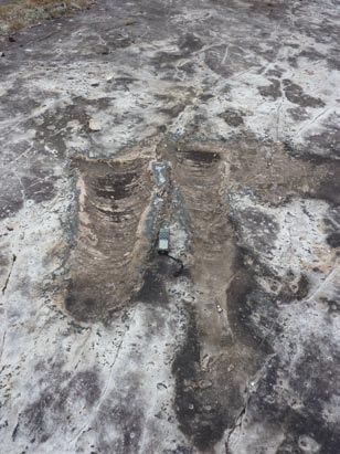
Nepean Fm. cross-bedding                    Pseudomorph crystals in Nepean Fm.

        Turn left out of the parking area onto Richmond Rd. Drive north into Bells
Corners and through the intersection with Robertson Rd. Keep driving north on Moodie
Dr. to the Queensway (Hwy. 417), and merge onto the Queensway going east towards
downtown Ottawa. Keep going east on the Queensway until you get to the Bronson Ave.
exit ramp. Take the Bronson Ave. exit ramp, and turn right (south) onto Bronson Ave.
Drive south on Bronson Ave., over the Rideau Canal, past Carleton University and the
Heron Rd. exit. As you pass over Heron Rd. on Bronson Ave., take a right turn to merge
with Brookfield Rd. and proceed west along Brookfield Rd. Cross over the intersection
with Riverside Dr. onto Hog’s Back Rd. Just before the bridge over the Hog’s Back
water falls (where the Rideau Canal and Rideau River meet), turn right into the Hog’s
Back Park parking area.

Stop 4. Hog’s Back Falls- Ordovician Sedimentary Units

        From the Hog’s Back Bridge where it crosses the Rideau River, by looking
downriver one can get a good overview of the local geology. Exposed in the falls area
are Middle Ordovician sedimentary rocks which have been faulted, gently folded, and
tilted within small fault blocks as seen in the middle of the falls. Walk down onto the
observation area on the left side (west) of the falls. The Rockcliffe Fm. sandstone is
exposed here. The Rockcliffe Fm. sandstone is fine- to medium-grained, micaceous, and
the grains are cemented by calcite. This sandstone contains more feldspar and lithic
grains compared to the quartz-rich Nepean Fm. sandstone seen at previous stops. Also
visible are parting lineations, hummocky cross bedding and smaller, superimposed
linguoid ripples.

        Looking eastward across the river, are beds of the Hog’s Back Fm. and, at the top
of the cliff, the overlying Pamelia Fm. (basal unit of the Ottawa Group). The bedding of
the Hog’s Back Fm. is generally thinner than that of the Rockcliffe Fm., and consists of
argillaceous (clay-rich) dolostone, limestone and shale. The limestone beds display
ripple cross-lamination and contain abundant fossils such as ostracods and bivalves and
other skeletal fragments. Scattered through the more nodular limestone beds are quartz
granules. The argillaceous dolostone beds contain mud cracks and phosphate-rich
burrows. The Pamelia Fm. at the top of the cliff section, overlies the Hog’s Back Fm.,
and is comprised of bioturbated and phosphatic sandstone, shale and fossiliferous
limestone beds. Exposures of the Pamelia Fm. further downriver, display abundant
hemispherical stromatolites and, in some outcrops, good evidence of karst weathering.
Hog’s Back Falls from bridge Ripples in Rockcliffe Fm. sandstone
The next two stops will be on the north (Québec) side of the Ottawa River. As the
outcrops are along the edge of the river they are occasionally covered when the river
water level is high. As well, although the river is neither deep nor very fast at these
localities, trip participants must exercise caution and use common sense for safety sake.
From the parking area, turn right onto Hog’s Back Rd. and proceed over the
bridge to Prince of Wales Dr. Turn right (north) on Prince of Wales Dr. and drive
through the intersection with Heron Rd. / Baseline Rd. into the Central Experimental
Farm. Keep going on Prince of Wales Dr. until you come to the traffic circle. Go ¾ of
the way around the traffic circle, and drive along the Driveway (through the Central
Experimental Farm) until you come to stop lights at the intersection of Holland Ave. and
then Carling Ave. Proceed across Carling Ave., where the road becomes Island Park Dr.
Drive along Island Park Dr., under the Queensway, across Richmond Rd., across Scott
St. and across the Ottawa River Parkway until you are on the Champlain Bridge that
spans the Ottawa River. On the far side of Champlain Bridge (Province of Quebec), turn
left onto Boulevard de Lucerne. About 100 metres on the left is Samuel-de-Champlain
parking lot where you should park. Walk towards the Ottawa River to the paved path,
and, turning left, walk back towards the Champlain Bridge on the path. Just before the
bridge is a house, and across the pathway from the house, along the shore of the Ottawa
River and extending under the Champlain Bridge is the outcrop for Stop 5.
Unfortunately, if the river level is too high this stromatolitic limestone exposure will be
under water and inaccessible.Stop 5. Stromatolitic limestone
Along the shore of the Ottawa River is a continuous exposure of flat-lying Late
Ordovician (ca. 450 million years) limestone that is entirely made up of linked
stromatolite mounds. The stromatolitic limestone belongs to the Pamelia Fm. (Ottawa
Group) that was seen at the top of the sedimentary rock section at Stop 4. At this stop,
you can walk on the stromatolitic limestone for tens of metres, which indicates that there
was a widespread colony of the laminated stromatolites (blue-green algae) that thrived in
a shallow marine environment during the Ordovician. A modern analogue exists in Shark
Bay north of Perth, western Australia, where stromatolite columns are thriving in the
shallow marine, saline lagoons. At Shark Bay, the stromatolite column colonies coalesce
and elongate parallel to the prevailing tidal current that is perpendicular to the shoreline.
Similarly, at Stop 5, the individual domal stromatolites and coalesced stromatolites have
a preferred elongatation direction (north-south), which is inferred to be perpendicular to
the ancient shoreline that existed during the Ordovician. Furthermore, between some
stromatolite domes, ripples are preserved which have crests that have a north-south
orientation. The ripples are interpreted as being formed by long-shore currents, moving
parallel to the ancient shoreline.
Limestone beds that underlie the stromatolitic limestone are exposed just a little
farther from the shore when the level of the Ottawa River is low. In these limestone beds
there are no stromatolites but there are abundant fossil gastropods, which are absent in
the overlying stromatolite beds. Again, using the modern analogue at Shark Bay where
the stromatolites are thriving in a very saline shallow marine environment, the lack of
gastropods in the stromatolite beds at Stop 5 suggests that marine conditions that existed
during stromatolite growth were too saline for the gastropods to survive. This is
compatible to other modern settings, where it has been observed that grazing gastropods
destroy algal mats until the local tidal environment becomes too salty for the gastropods
to survive.
Domal stromatolites, Champlain Bridge in backgroundTurn right from the parking lot onto Boulevard de Lucerne. Cross over Place
Samuel-de-Champlain, and continue on Boulevard de Lucerne. Turn right (south) onto
Rue Bégin, and then right again on Rue Maricourt and park beside Parc Brébeuf next to
the Ottawa River. Walk to the shoreline rock exposures behind the statue of Jean de
Brébeuf.
Stop 6. Fossiliferous limestone
The fossiliferous (fossil-rich) limestone, exposed along the shore of the Ottawa
River, is part of the Late Ordovician Ottawa Group of sedimentary rocks. As such,
preserved within the limestone are fossil remnants of the animals that lived in the shallow
marine environment that existed in the Ottawa area approximately 450 million years ago.
The flat-lying limestone offers a bedding surface view of the fossils derived from the
animals that swam above, crawled over, or were rooted to the limey Ordovician seabed.
The variety of fossils in the limestone include: corals, stromatoporoids (ancient sponges),
straight-shelled cephalopods (orthocones), whorled gastropods, brachiopods, crinoids
(mainly their stems), fragments of trilobite shells, and evidence of animal activity (trace
fossils) such as burrows and trails. The retaining wall along the shore is made from
locally-derived limestone, that not only contains some of these fossils, but also offers a
three-dimensional view of some of the primary and secondary sedimentary structures
such as, respectively, bedding, cross-bedding, ripple lamination and stylolites and
jointing.
Another interesting local feature is the base of the statue of Jean de Brébeuf. The
rounded cobbles used to make the base for the statue were derived from a local gravel pit
in coarse Pleistocene outwash. They represent different types of Precambrian rocks
(mainly metamorphic and igneous rocks) that were eroded from the Gatineau Hills and
further north during the Wisconsin Ice Age (Pleistocene); they were rounded and
polished during subglacial transportation during melting of the ice.
Statue of Jean de BrébeufDrive north on Rue Bégin to Boulevard Alexandre-Tache and turn right (east)
towards Hull. Follow Boulevard Alexandre-Tache to Rue Eddy and the Chaudières
Bridge. Turn right onto the bridge. Drive ¾ of the way across the bridge, towards
Ottawa, to Victoria Island, and turn left at Middle St. Park near the old generating
station. Walk down the sloping road to the outcrop on either side of the road, before it
passes under Portage Bridge.
Stop 7. Dunes and fossiliferous limestone
These outcrops are Ottawa Group fossiliferous limestone, similar to Stop 6,
except that they contain dune-scale bedforms (>4 cm amplitude). The vertical section of
the outcrops on either side of the road, show alternation between limestone beds
containing abundant fossil fragments (brachiopods, bryozoa, cephalopods and crinoids)
and dunes, and limestone beds that are flat-lying and contain abundant feeding burrows
and trails (trace fossils). One interpretation of this bedding style alternation may be that
it reflects environment changes between stormy periods (sediment and fragmented fossil
transportation by dunes along the sea floor) and calmer, ‘fair weather’ periods with little
sediment transportation and more feeding by benthic animals. Occasional mudcracks in
the vertical section indicate periodic exposure, resulting in desiccation of the limy
sediment. It is also possible that the changing character of the limestone beds reflects
periodic rising (deepening) and falling (shallowing) of sea level. The beds that are rich in
trace fossils and few dunes, may reflect a deeper water quiet environment that was below
normal ‘fair weather’ wave base.
From the east end of Victoria Island look towards Parliament Hill on the south
side of the Ottawa River. You can clearly see the sedimentary rock layers in the cliff
faces beneath the Parliament Buildings, Supreme Court and the National Archives.
These are primarily units of the Late Ordovician Ottawa Group. A thin veneer (≤1-2 m)
of unconsolidated Pleistocene sediment lies on top of the Ottawa Group.
Dunes and fossiliferous limestoneThis concludes the Geology of the Ottawa Area field trip. There is still a lot of
interesting geology to see in and around Ottawa and the Gatineau Hills, and the
Ottawa-Gatineau Geoheritage Committee hopes that you will be able to see more in the
future, perhaps following a self-guided field trip compiled from our website. We also
hope that you now understand the importance of preserving, protecting and promoting
the natural geoheritage of the Ottawa-Gatineau area, and that you can, in turn,
impress this upon your friends and colleagues. Offered below is a brief bibliography
where you can find out more about various aspects of geology in the Ottawa-Gatineau
area. As well, there is a brief overview of the Ottawa-Gatineau Geoheritage Project.
BIBLIOGRAPHY
The following publications can be found at the Geological Survey of Canada library (601
Booth St., Ottawa), Carleton University MacOdrum library (1125 Colonel By Dr.,
Ottawa) and the University of Ottawa Morisset Library (65 University, Ottawa).
Bélanger, J.R. 1998. Urban geology of Canada’s National Capital area. In: P.F. Karrow
and O.L. White (Eds.). Urban geology of Canadian cities. Geological Association of
Canada, Special Paper 42.
Fulton, R.J. (Ed.) 1987. Quaternary geology of the Ottawa region, Ontario and Quebec.
Geological Survey of Canada, Paper 86-23.
Hoffman, P.F. 1989. Precambrian geology and tectonic history of North America. In:
The geology of North America; an overview. A.W. Bally and A.R. Palmer (Eds.). The
Geological Society of America.
Hogarth, D.D., Rushforth, P. and McCorkell, R.H. 1988. The Blackburn carbonatites,
near Ottawa, Ontario: dykes with fluidized emplacement. Canadian Mineralogist, vol.
26, pages 377-390.
Sabina, A.P. 1987. Rocks and minerals for the collector. Hull-Maniwaki, Quebec;
Ottawa-Peterborough, Ontario. Geological Survey of Canada, Miscellaneous Report 41.
Williams, D.A. 1991. Paleozoic geology of the Ottawa – St. Lawrence Lowland,
southern Ontario. Ontario Geological Survey, Open File Report 5770.
Wilson, A.E. 1946. Geology of the Ottawa – St. Lawrence Lowland, Ontario and
Quebec. Geological Survey of Canada, Memoir 241.The OTTAWA-GATINEAU GEOHERITAGE PROJECT was started in 2002 to promote public
awareness of the geological and landscape aspects of natural history in and around Canada’s National
Capital Region.
THREE MAIN OBJECTIVES of the Ottawa-Gatineau Geoheritage Project are:
• PRESERVATION of world-class geoheritage sites, by minimizing the loss of irreplaceable
geological and surface landform features of the Ottawa-Gatineau region through insightful land-
use planning
• PROTECTION of geoheritage sites by strengthening and enforcing applicable laws to preserve
significant records of natural history
• PROMOTION of public awareness through the production of informative signs, brochures and
guidebooks for geoheritage sites
The preservation, protection and promotion of geoheritage sites in the Ottawa-Gatineau region involve
the stewardship of local natural features, and education of people living in the region. Provision of greater
geoheritage recognition can be expected to stimulate tourism and international interest in the region.
Considerable interest and support for this geoheritage initiative already has been shown by representatives
of Carleton University, University of Ottawa, the City of Ottawa, the National Capital Commission,
Natural Resources Canada and Ontario Parks.
GEOHERITAGE AND GEOHERITAGE SITES
Geoheritage is concerned with the recognition and preservation of significant natural features,
such as distinctive fossils and rare minerals, exposures of major faults and unconformities (erosional gaps
in the rock record), unique glacial and post-glacial deposits, and the interaction that human activity has had
with these natural features (e.g. natural stone in heritage buildings, and distinctive geological relationships
revealed in quarries, road cuts, building excavations and abandoned mines).
Many unique geological and surface landform features provide important records of the past in the
Ottawa-Gatineau region. These include the billion-year-old Precambrian rocks of the Gatineau Hills, the
450 million-year-old fossil-bearing Paleozoic rocks of the Ottawa Valley and the unconsolidated sediments
produced during the last Ice Age and during the subsequent time when the Champlain Sea covered much of
the Ottawa Valley, less than 10,000 years ago. The present drainage systems, dominated by the Ottawa
River, have been incised into this geological assemblage, and many areas within the region have been
subjected to significant modification by landslides. These components of our local natural history stronglyinfluence the groundwater reservoirs, surface waterways, agriculture sustenance, mineral wealth,
biodiversity and the foundations for buildings and transportation.
A Geoheritage Site is a locality that meets one or more of the following:
• Exposes a significant record of natural history
• Contains characteristic or unique features
• Contributes to understanding the natural history of the region
• Offers new scientific insights
• Offers distinct aesthetic and cultural values
OTTAWA-GATINEAU GEOHERITAGE COMMITTEE
A voluntary committee of geoscientists, educators and communicators who live and work in Ottawa
and Gatineau meet regularly to advance the Project’s goals. Members of the Ottawa-Gatineau Geoheritage
Committee are willing to assist the public, Municipal, Provincial and Federal Committees or Agencies,
Primary and Secondary Schools, Museums, Societies and Public Interest Groups in a variety of activities in
the Ottawa-Gatineau region. These activities include:
• Striving to preserve, protect and promote local Geoheritage Sites through liaison with the
appropriate Municipal or Federal authorities
• Composing Geoheritage Site signage
• Preparing Geoheritage Site information brochures
• Conducting Geoheritage tours of the Ottawa-Gatineau region
• Offering lectures on the natural history of the Ottawa-Gatineau regionYou can also read