GGOS Focus Area Unified Height System: Ongoing activities - TUM
←
→
Page content transcription
If your browser does not render page correctly, please read the page content below
Deutsches Geodätisches Forschungsinstitut (DGFI-TUM)
Technische Universität München

GGOS Focus Area Unified Height System:
Ongoing activities
Laura Sánchez

Deutsches Geodätisches Forschungsinstitut (DGFI-TUM)
Technische Universität München

GGOS Coordinating Board Meeting
Vienna, Apr. 7, 2018
Objective
Implementation of the International Height Reference System (IHRS) and its
realisation IHRF (International Height Reference Frame) introduced by the IAG
Resolution No. 1, Prague, July 2015. Primary actions are:

1. Station selection for the IHRF reference network

2. Strategy for the determination of high-precise primary
   coordinates XP, ẊP, WP, ẆP at the IHRF reference
   stations

3. Identification and preparation of standards and
   conventions to ensure consistency between the
   definition (IHRS) and the realisation (IHRF); i.e., an
   equivalent documentation to the IERS conventions is
                                                                                        IHRS/IHRF coordinates according to
   needed for the IHRS/IHRF                                                               the IAG Resolution No. 1, 2015

Deutsches Geodätisches Forschungsinstitut (DGFI-TUM) | Technische Universität München                                        2
Activities related to the IHRF reference network
Sep. 2016 (GGHS2016, Thessaloniki): Criteria for selection of IHRF stations
Oct. 2016 (GGOS Days 2016, Cambridge, MA): Preliminary IHRF station selection
Nov. 2016 – Mar. 2017: Interaction with regional and national experts about the
preliminary station selection and proposal for further geodetic sites
Apr. 2017 (EGU2017, Vienna): First proposal for the IHRF reference network.
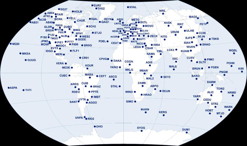
IHRF reference network as of April 2017 (163 stations)
Deutsches Geodätisches Forschungsinstitut (DGFI-TUM) | Technische Universität München 3Interaction with regional/national experts for
the IHRF station selection
IGIK-Pl: J. Krinsky
DTU-Dk: R. Forsberg
AUTH-Gr: G. Vergos
LGIA-LV: I. Liepins
LM-Se: J. Ågren, Nordic Geodetic Commission (NGK)
Swisstopo-Ch: U. Martí
NRCan: IGN-Es: P. Vaquero
M. Véronneau, NLS-Fi: M. Poutanen
J. Huang
FSBI: I. Oshchepkov
NGS/NOAA: D. Roman,
K. Choi, K. Ahlgren
SIRGAS: W. Martínez,
M.V. Mackern, S. Freitas
AGGO: C. Brunini
LINZ-Nz: M. Amos
INEGI: D. Avalos
GA-Au: R Ruddick
IGN-CR: A. Álvarez
Curtin-Au: W. Featherstone
IGM-Ec: C. Estrella
IGN-Pe: J. Chire
IGM-Cl: C. Iturriaga
IGM-Bo: A. Echalar
IGN-Ar: D. Piñon IGS stations
SGM-Uy: N. Suárez Since Aug. 2017:
IBGE: S. Costa, R. Luz H.A. Abd-Elmotaal (Egypt)
EPUSP: D. Blitzkow, A.C.O.C. Matos K. Matsuo (Japan)
Deutsches Geodätisches Forschungsinstitut (DGFI-TUM) | Technische Universität München 4Activities related to the IHRF coordinates (1/2)
May to Aug. 2017: Numerical tests for the computation of potential values at the
IHRF stations: Discrepancies up to the dm-level!
What should we do? - Discussions at the IAG-IASPEI Assembly (Aug. 2017, Kobe):
1. To compute IHRF coordinates using exactly the same input data and the own
methodologies/software of colleagues involved in the gravity field modelling
2. Based on the comparison of the results, to identify a set of standards that
allow to get as similar and compatible results as possible.
Deutsches Geodätisches Forschungsinstitut (DGFI-TUM) | Technische Universität München 5Activities related to the IHRF coordinates (2/2) Dec. 2017 - Jan. 2018: A set of basic (minimum) standards/requirements for the computation of potential values within the IHRF experiment was prepared (L. Sánchez, J. Ågren, J. Huang, Y.M. Wang, R. Forsberg) Feb. 2018: Y.M. Wang (NGS/NOAA) provided terrestrial gravity data, airborne gravity, and a digital terrain model for an area of about 700 km2 in Colorado, USA Since Feb. 2018: Different computation groups are working with these data Sep. 2018 (GGHS2018 Symposium, Copenhagen): Expected evaluation of the first results of this experiment. Deutsches Geodätisches Forschungsinstitut (DGFI-TUM) | Technische Universität München 6
Networking within the IAG This experiment is supported by: GGOS JWG: Strategy for the Realisation of the IHRS (chair: L. Sánchez) IAG JWG 2.2.2: The 1 cm geoid experiment (chair: Y.M. Wang) IAG SC 2.2: Methodology for geoid and physical height systems (chair: J. Ågren) ICCT JSG 0.15: Regional geoid/quasi-geoid modelling - Theoretical framework for the sub-centimetre accuracy (chair: J. Huang) IGFS: International Gravity Field Service (chair: R. Barzaghi, director CB: G. Vergos) GGOS JWG: Establishment of the GGRF (chair: U. Martí) 39 colleagues from 23 countries are contributing to this experiment: A. Ellmann (EE), A.C. de Matos (BR), B. Erol (TR), C. Hwang (TW), D. Avalos-Naranjo (MX), D. Blitzkow (BR), D. Pangastuti (ID), D. Roman (US), D. Smith (US), D. van Westrum (US), G. Vergos (GR), H. Abd-Elmotaal (EG), H. Denker (DE), H. Sarid (IL), I. Oshchepkov (RU), J. Ågren (SE), J. Huang (CA), J. Li (CN), K. Ahlgren (US), K. Matsuo (JP), L. Sánchez (DE), L. Sjöberg (SE), M. Filmer (AU), M. Sideris (CA), M. Varga (HR), M. Véronneau (CA), M. Willberg (DE), R. Barzaghi (IT), R. Pail (DE), R. Forsberg (DK), S. Claessens (AU), S. Dalyot (IL), S. de Freitas (BR), S. Hilla (US), T. Jiang (CN), V. N. Grigoriadis (GR), W. Featherstone (AU), X. Li (US), Z. Qilong (CN) Deutsches Geodätisches Forschungsinstitut (DGFI-TUM) | Technische Universität München 7
More information about publications, presentations, reports, business
meetings, etc. at http://ihrs.dgfi.tum.de, www.ggos.org

Deutsches Geodätisches Forschungsinstitut (DGFI-TUM) | Technische Universität München   8
You can also read