Ghana Water Resources Profile Overview - WATER RESOURCES PROFILE SERIES - Winrock ...
←
→
Page content transcription
If your browser does not render page correctly, please read the page content below
WATER RESOURCES PROFILE SERIES
The Water Resources Profile Series synthesizes information on water resources, water quality, the water-related dimen-
sions of climate change, and water governance and provides an overview of the most critical water resources challenges
and stress factors within USAID Water for the World Act High Priority Countries. The profile includes: a summary of avail-
able surface and groundwater resources; analysis of surface and groundwater availability and quality challenges related
to water and land use practices; discussion of climate change risks; and synthesis of governance issues affecting water
resources management institutions and service providers.

Ghana Water Resources Profile Overview
          Ghana has abundant water resources and is not considered water stressed overall. The total volume of freshwater
          withdrawn by major economic sectors amounts to 6.3 percent of its total resource endowment, which is lower
          than the water stress benchmark.i Total renewable water resources per person of 1,949 m3 is also above the
          Falkenmark Indexii threshold for water stress. However, water availability is influenced by management decisions
          and abstractions from upper-basin countries as almost half of its freshwater originates outside the country.

          The Volta Basin covers most of the country and is critical to hydroelectric generation, agriculture, and fisheries.
          However, water availability for hydropower generation and agriculture is vulnerable to drought and depends on
          upper basin dam releases and abstractions in Burkina Faso. Flood risks are amplified by uncoordinated floodgate
          releases from upstream dams. Transboundary cooperation is needed to reconcile basin development plans and
          address flood mitigation and drought contingencies in the Volta Basin.

          Informal gold mining, logging, and the expanding cocoa sector are increasing flood risks, erosion, and
          sedimentation in the Southwestern and Coastal Basins. Gold mining contaminates municipal water sources with
          heavy metals, especially in the Pra Basin. Municipal, domestic, and industrial waste also contaminate 60 percent
          of surface waters and degrade ecosystems and biodiversity, especially downstream of Kumasi and Accra.

          Groundwater resources are more limited compared to surface water. Aquifers generally have low productivity,
          limiting their viability for large-scale agriculture, municipal, and industrial use. Groundwater is used extensively
          for drinking water and domestic use in rural areas, especially in northern Ghana. Naturally occurring heavy metals
          are present in gold mining belts in the southwest and the northwest and naturally high fluoride in the north pose
          risks to public health. Seawater intrusion in coastal aquifers reduces groundwater quality in coastal cities.

          Ghana is one of the most flood prone countries in West Africa. Climate change is worsening flooding, particularly
          in the north, while rising seas threaten coastal wetlands, biodiversity, and communities. Drought frequency and
          severity are increasing in the Volta Basin, impacting hydroelectric power generation, irrigation water supply, and
          agricultural and fishery production. Flood risks are worsened by poor urban planning and low enforcement of
          land use policies and could be alleviated by harnessing green infrastructure for flood management.

         The Water Resources Commission lacks funding, sufficient staffing, and technical capacity needed to create
         and implement basin management plans and establish Basin Secretariats. The water sector’s policy and legal
         framework do not adequately incorporate key government stakeholders and management entities into basin
         planning processes and address conservation needs, including for forests and wetlands.

iSDG  6.4.2 measures water stress as the percentage of freshwater withdrawals against total renewable freshwater resources. The water stress thresholds
are: no stress 100%.
iiThe Falkenmark Water Stress Index measures water scarcity as the amount of renewable freshwater that is available for each person each year. A

country is said to be experiencing water stress when water availability is below 1,700 m3 per person per year; below 1,000 m3 is considered water
scarcity; and below 500 m3 is absolute or severe water scarcity.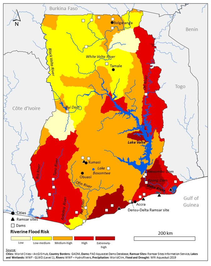
Water Resources Availability
KEY TAKEAWAYS
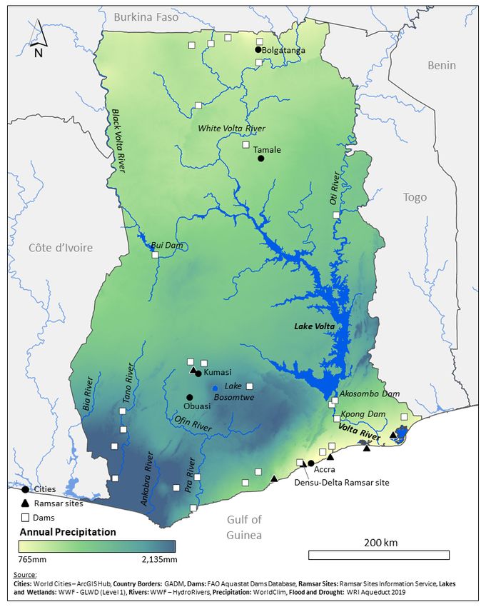
Ghana has three main basins that outlet to the Gulf of Guinea. The transboundary Volta Basin covers most of the country and
provides the majority of renewable surface water. Rainfall is highest in the southwest while northern Ghana is drier and features semi-
arid savannas.
The Akosombo Dam in southeastern Ghana forms Lake Volta and is one of the world’s largest reservoirs.
Groundwater mostly exists in hard rock aquifers with relatively low productivity.
This section summarizes key characteristics of surface and groundwater resources. Table 1 summarizes key water
resources data and Figure 1 presents key surface water resources, wetlands, and dams.
Surface Water Resources almost one-third of Ghana’s total runoff due to high
Ghana has three main basins that outlet to the Gulf of precipitation within the Bia, Tano, Ankobra and Pra
Guinea: the Volta, Southwestern, and Coastal Basins. Basins. 5 The Coastal Basin contributes six percent of
The transboundary Volta Basin contributes almost two- Ghana’s total runoff, with the Densu Basin sustaining the
thirds of total runoff,1 and is divided into the Black Volta, Densu Delta, a key Ramsar Site.6
White Volta, Oti River, and Lower Volta Basins. The Black
Volta joins the White Volta at the northwestern corner Groundwater Resources
of Lake Volta, which is formed by the Akosombo Dam Most groundwater is contained in basement complexes
(147,960 MCM capacity) and is one of the largest artificial or consolidated sedimentary formations and are not very
reservoirs in the world. The Black Volta is characterized productive. Basement complexes cover 54 percent of the
by high seasonal variability, with average wet season country, mostly in the west, south central, and the north.
flows ten times higher than in the dry season.2 The White Consolidated sedimentary formations are present in most
Volta Basin is smaller, however, the River’s flow is higher of the Volta Basin. Aquifer depth is shallow (10-60 meters)
and covers more of Ghana. The White Volta’s flows are while well yields are generally low. More productive
moderated by Burkina Faso’s Bagre Dam and seasonal limestone aquifers exist along the southeastern and
flows of its tributaries.3 The Oti River joins the Volta River southwestern coasts at greater depths (120-300 meters)
near Kete Krachi and contributes 40 percent of Lake with high average well yields, but these systems only
Volta’s annual inflows.2 The Lower Volta Basin consists of underlie one percent of the country. Groundwater
numerous small rivers and Lake Volta.2,4 recharge is generally low and highly variable, ranging
from 1.5 to 19 percent of rainfall, with higher rates in the
The Southwestern Basin is relatively small but contributes upper Volta Basin.1
Sub-Saharan Africa
TABLE 1. WATER RESOURCES DATA Year Ghana
(median)
Long-term average precipitation (mm/year) 2017 1,187 1,032
Total renewable freshwater resources (TRWR) (MCM/year) 2017 56,200 38,385
Falkenmark Index - TRWR per capita (m3/year) 2017 1,949 2,519
Total renewable surface water (MCM/year) 2017 54,900 36,970
Total renewable groundwater (MCM/year) 2017 26,300 7,470
Total freshwater withdrawal (TFWW) (MCM/year) 2000 982 649
Total dam capacity (MCM) 2015 148,500 1,777
Dependency ratio (%) 2017 46.09 22.78
Interannual variability 2013 1.4 1.55
Seasonal variability 2013 3 3.15
Environmental Flow Requirements (MCM/year) 2017 33,260 18,570
SDG 6.4.2 Water Stress (%) 2000 6.31 5.70
Source: FAO Aquastat
2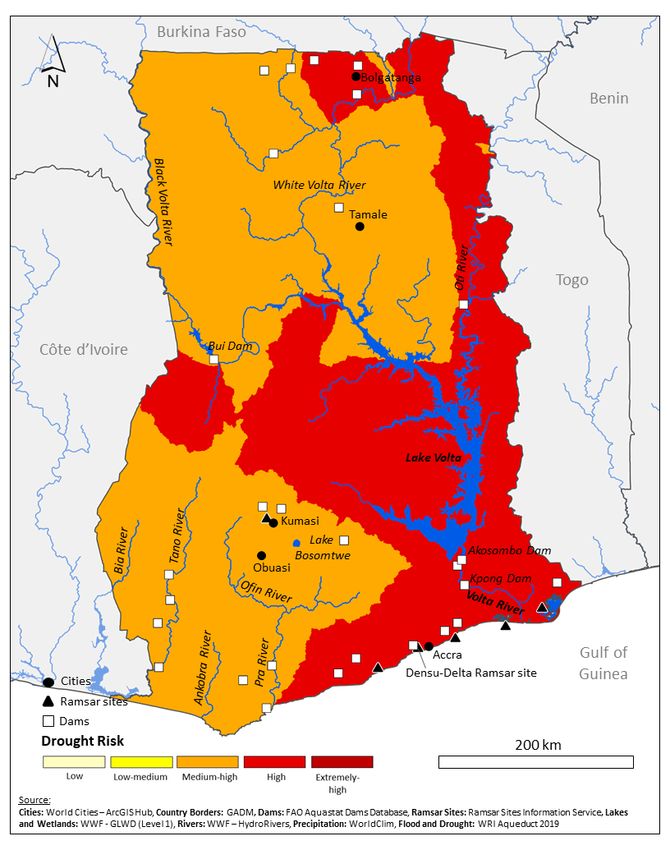
FIGURE 1: MAP OF WATER RESOURCES

                                   3
Surface Water Outlook
                                                                 KEY TAKEAWAYS

           Irrigation in the Volta Basin is the largest source of surface water withdrawals, although non-consumptive uses from Lake Volta are
           critical to the economy, including hydropower generation and inland fisheries.

           Wet season flood risks and hydroelectric generation on Lake Volta are impacted by water management decisions and discharges
           from upstream dams in Burkina Faso.

           Informal gold mining and logging, as well as expanding cocoa production degrade watersheds throughout the Southwestern and
           Coastal Basins, creating high wet season turbidity which can disrupt municipal water treatment. Gold mining contaminates rivers in
           the Southwestern Basin with toxic heavy metals.

           Municipal, industrial, and domestic waste contaminate rivers throughout the Coastal and Southwestern Basin and degrade
           ecosystems and biodiversity in key wetlands.

    This section describes key sources of demand and uses of surface water, and associated challenges stemming
    from water availability and water quality challenges.

    The agricultural sector is the largest water user (73                      Catchments in the Southwestern and Coastal Basins
    percent of total withdrawals), followed by municipal/                      are severely degraded by informal logging and
    domestic (20 percent), and industry (7 percent). Most                      surface mining for gold, as well as the expansion of
    withdrawals are from surface water. Most agriculture                       cocoa production. These cause sedimentation, increase
    is rainfed and only 30,900 hectares irrigated nationwide,                  flood risks, reduce water quality, and threaten biodiversity
    less than 2 percent of its total irrigation potential. 7                   and communities. 22 Recent estimates suggest that
    Large public irrigation systems in the Volta Basin and                     up to 70 percent of total timber production is from
    small reservoirs and dugouts in the north are the main                     informal logging.23 Ghana is also one of the largest gold
    mechanisms of abstraction and use of surface water for                     producers globally and over one-third of the country’s
    livestock watering and small-scale irrigation.2                            total production comes from small-scale, open pit mining
                                                                               called galamsey,24 which degrades seven times more area
    The Investing for Food and Jobs Initiative prioritizes                     than large-scale mining. Galamsey-driven deforestation
    investments for rehabilitation and expansion of large                      doubled from 2015 – 201824 and it is estimated that
    public irrigation systems, and calls for allocating 10                     restoring land and waterways degraded by galamsey
    percent of the national budget to support agriculture.8                    will cost a total of $250 million for the Western Region
    However, the percent of cultivated land under irrigation                   alone.25 Large-scale open-pit mining is also common in
    is projected to be 3.5 percent by 2023.9 The recently                      the southwest, including more than 10 large-scale mines
    c o m p l e t e d “ O n e V i l l a g e – O n e D a m ” p ro g r a m       in the Ankobra Basin.24
    constructed dug-out reservoirs for villages across
    northern Ghana,10 but reports indicate that many of these                  Ghana produces one-fifth of global cocoa and recent
    reservoirs cannot be used for irrigation and are empty in                  investments may double national output.26 Ghana lost
    the dry season.11–13 The Volta Basin also has important                    eight percent of remaining primary forest (2002- 2019),
    non-consumptive uses, including transportation, tourism,                   mostly from cocoa expansion.29 Between 2017 and 2018,
    aquaculture, and hydropower generation through the                         Ghana’s deforestation rate of primary forests increased
    Akosombo, Bui, and Kpong Dams.14,15 Notably, around                        by 60 percent, faster than any country in the world.
    40 percent of Ghana’s electrical production is from                        Agricultural encroachment (mostly from cocoa) degrades
    hydropower.16                                                              30 to 60 percent of forests in reserves and the degraded
                                                                               area has increased tenfold since 2010.30
    Poor coordination and management of upstream
    dams in Burkina Faso can lead to heavy flooding                            Heavy metals, mainly from small-scale gold mining,
    in Ghana’s Volta Basin. Uncoordinated releases from                        pollute rivers and key drinking water sources
    Bagre Dam have flooded riparian communities along                          throughout the Southwestern Basin. Heavy metal
    the White Volta River.15 In 2018, around 100,000 people                    pollution from gold mining has been observed in
    were displaced by floods caused by heavy rainfall and                      Southwestern Basin’s Tano and Ankobrah Basins,
    releases from Bagre Dam.19,20 The transboundary Volta                      but is worst in the Pra Basin where gold mining
    Basin Authority’s mandate encompasses flood forecasting                    is concentrated. 31 Gold mining has led to water
    and coordination among member states, although its                         service disruptions in several towns due to extreme
    effectiveness is hampered by inadequate hydrological                       contamination of surface water.14,35,36 Arsenic levels near
    forecasting and modeling, poor coordination and                            Prestea (Pra Basin) have also been detected at nearly 800
    communication between basin states, and a lack of                          times the WHO guideline limit for drinking water, most
    effective early warning systems for floods.21                              likely from gold mining.34

4
Untreated industrial, municipal, and domestic waste likely derive from industrial and municipal pollution.39
deplete oxygen levels in rivers while high turbidity
in the wet season can disrupt water treatment and Agricultural and urban runoff harms biodiversity in
service delivery. Approximately 60 percent of surface Ghana’s Ramsar sites and 80 wetlands. Anthropogenic
water is polluted nationwide14 and is most severe in the pollution has caused significant biodiversity losses in
Southwestern and Coastal Basins, especially downstream southern lagoons such as Korle, Kpeshie, and Sakumo.40
of Kumasi and Accra. 37,38 Municipal and industrial Upstream agriculture and wastewater pollution from
effluent has led to high concentrations of fecal coliforms Takoradi has led to critically low dissolved oxygen and
and “dead zones” from deoxygenation in the Subin decimated fish populations in the Essei Lagoon.41,42
River in Kumasi.35 High turbidity in the Pra basin has Similarly, biodiversity in Lake Bosomtwe has suffered
significantly increased water treatment costs and left from high sedimentation from upstream deforestation, as
some plants inoperable for several months each year.35 well as eutrophication from nearby agriculture, leading to
The lower Volta River also has high chromium levels that large declines in fish populations.43
Groundwater Outlook
KEY TAKEAWAYS
Almost all groundwater abstractions are for drinking water and domestic use, primarily in rural areas. Dependence on groundwater is
significantly higher in northern Ghana.
Nationally, the risk of over abstraction of groundwater is low, although in some cases, significant fluctuations in the water table due to
drought and seasonal recharge, which may worsen with climate change, hinder accessibility.
Groundwater quality is generally good throughout Ghana, but gold mining belts in the north and southwest are contaminated by
heavy metals, and naturally high fluoride contaminates drinking water in northern Ghana, posing health risks.
Localized risks in urban areas from poor sanitation systems, over-abstraction, and sea level rise in coastal cities like Accra also affect
groundwater availability and quality.
This section describes key sources of demand and uses of groundwater, and associated challenges stemming from
water availability and water quality challenges.
G ro u n d w a t e r i s w i d e l y u s e d f o r c o m m u n i t y - rainfall for recharge and potential vulnerability to
level drinking water supply as it is more reliable, drought.46 Models suggest that climate change impacts
particularly in periods of drought, and often does not such as higher evaporation rates, reduced rainfall, and
require much treatment. Approximately 41 percent of drought will reduce groundwater recharge significantly in
the population depend on groundwater for household several basins.37,38,48
use, although this rate is much higher in rural areas (59
percent) than in urban areas (16 percent). Groundwater Groundwater quality is generally acceptable for most
dependency is highest in northern Ghana due to low uses, although naturally occurring heavy metals and
seasonal availability of surface water. Groundwater fluoride are high in gold mining belts in the north
abstraction for irrigation and animal husbandry occur and southwest. Heavy metals such as lead, arsenic, and
primarily in the northern Volta Basin, and for industry cadmium have been found above WHO guideline values
in the south around Accra, but these abstractions are for drinking water, especially in the southwest49,50 and in
nominal compared to domestic use.1,45 northern Ghana, where contamination is most severe and
widespread.51 Much of this contamination may be natural
Groundwater availability and risks stem from poor and is often associated with gold deposits.51,52 Similarly,
regulation and enforcement, a lack of reliable data, high arsenic concentrations have been found around
drought, and reduced recharge from climate change. key gold mining zones around Obuasi (Pra Basin) and
Recent estimates on renewable groundwater supply Bolgatanga (White Volta Basin), well in excess of WHO
and withdrawals indicate that total withdrawals are very guideline values for drinking water.52 Naturally occurring
low compared to renewable supply. However, localized fluoride is also present and in excess of WHO guideline
depletion often occurs as most wells are clustered and values in deeper boreholes.53 One study concluded that
unregulated. The Water Resources Commission monitors 20 percent of sampled wells in the Northeastern Region
groundwater levels in 70 wells nationwide, although exceeded WHO guideline values for fluoride.54 Improved
technical issues reduce the consistency and quality of groundwater quality monitoring is needed, particularly in
data.46,47 Inter-annual groundwater levels are relatively gold mining zones, to better assess risks to public health.
stable although seasonal fluctuations can range one to
seven meters, indicating a high dependency on seasonal
5Shallow groundwater is increasingly susceptible to and poultry.56 There are over 45,000 hand dug wells in
pollution from inadequate sanitation systems in cities, Ghana and only half are suitable for drinking due to water
and from sea level rise and over pumping in coastal quality problems from high turbidity, nitrates, and fecal
aquifers. Only one-third of wastewater is safely disposed coliforms.53,57 Salinity is a growing problem in coastal
of in Accra, while sewerage systems only receive 10 aquifers due to seawater intrusion. In the greater Accra
percent of all wastewater. As of 2014, poor maintenance region, high salinity has limited the use of boreholes for
limited Accra’s wastewater treatment plants to one-fifth drinking and irrigation in small farming communities.
their design capacity.55 Shallow groundwater is widely In the Densu Basin, salinity is likely caused by seawater
contaminated by sources such as bathhouses, landfills, intrusion as result of concentrated abstractions.38
latrines and septic tanks, and animal waste from pigs
Water Resources and Climate
KEY TAKEAWAYS
Climate change is reducing precipitation, increasing temperatures, and increasing evaporation rates in the Volta Basin, creating
widespread risks to water availability across northern Ghana.
Warmer temperatures are reducing the productivity of coastal and inland fisheries (Lake Volta) and impacting agriculture in northern
Ghana.
Ghana is one of the most flood prone countries in West Africa. Climate change will increase the intensity and frequency of flooding
due to sea level rise and higher precipitation intensity. Urban slums and riverine communities in northern Ghana are particularly
vulnerable to flood risks.
This section covers climate variability and climate change, their impacts on water availability and water quality, and
the risks they pose to local communities and their economies.
Declining rainfall and higher evapotranspiration will industry and cause economic losses of several hundred
reduce water availability in the transboundary Volta million dollars.65,66 Over the past few decades, drought
Basin and increase vulnerability to drought. Northern has caused national hydroelectric production to fall to 33
Ghana is semi-arid and experiences one rainy season (May- percent of capacity in some cases.67 Ghana’s fisheries are
September) while southern Ghana has two rainy seasons also considered highly vulnerable to climate change, and
(April-July, and September-November). Mean annual inland fisheries in Lake Volta have been declining due to
rainfall is approximately 1,200 mm however total annual increasing temperatures.17
rainfall ranges between 1100 mm/year in the north to 2,100
mm/year in the southwest.58 Climate change is expected Growing water demand in the Volta Basin’s uppermost
to raise average annual temperatures by 1.7-3.5 °C by the states will worsen impacts of drought and strain water
end of the century. While the impact on total precipitation supply across northern Ghana. 60 Without adaptive
is uncertain, higher temperatures will increase evaporation practices, higher temperatures and drought will reduce
and cause water losses. 59 Climate change impacts on agricultural production and viable farmland, especially
upper Volta Basin countries, particularly Burkina Faso, will in the northern cocoa-growing regions. Some estimates
also impact water resources in Ghana. suggest that over one-third of Ghana is vulnerable to
desertification,68 which degrades 20,000 hectares per year
Declining rainfall and higher evapotranspiration rates in in the north.69
Burkina Faso could reduce the Volta River’s annual flow
by 24 percent by 2050 and 45 percent by 2100. 60,61 Flood risks are increasing with climate change,
Poor governance and low adaptive capacity increase particularly in urban areas and riverine communities in
the vulnerability of affected populations in northern northern Ghana. Sea level rise is reducing freshwater
Ghana.58,62,63 Reductions in water availability may increase availability and harming coastal wetlands. Between
tensions with neighboring Burkina Faso as it pursues further 1988 and 2010, Ghana experienced 15 major floods
development of its water resources.58 that displaced hundreds of thousands of people. 70 In
2010, 700,000 people were displaced after heavy rainfall
Higher temperatures and increasing water stress in destroyed a dam and in 2015 flash flooding in Accra killed
the Volta Basin threaten hydropower generation and more than 150 people and caused over $100 million in
inland aquaculture at Lake Volta, as well as agriculture damage.71 Precipitation is becoming more variable and
across northern Ghana. Hydropower generated at the intense, which is increasing flood severity and impact.58,72
Akosombo Dam is highly sensitive to changes in Lake Coastal populations, which comprise one-quarter of the
Volta’s water level.64 Most shortfalls in hydroelectric power population and include five major cities, will become
generation derive from rainfall variability, which disrupt more exposed to flooding.73,74 Sea level has already risen
6by over 60mm, and may rise an additional 75-190mm programs have been shown to prevent coastal erosion and
by 2100.58 Rising sea levels will increase erosion and reduce impacts from coastal storms, although programs
shoreline loss along the coasts and in wetlands,58 and should also focus on improved governance.75
increase salinity in coastal aquifers.73 Mangrove restoration
FIGURE 2: DROUGHT RISK FIGURE 3. RIVERINE FLOOD RISK
Water Policy and Governance
KEY TAKEAWAYS
Low levels of staffing, funding, technical capacity, and data constraints impede basin management, slows the establishment of new
Basin Secretariats, and affects the ability of water management entities to address risks from agriculture, mining, and deforestation.
Limited stakeholder engagement and institutional collaboration in basin planning and water management impedes the regulation
and conservation of wetlands, riparian corridors, forests, and groundwater.
Groundwater quality is not monitored, and surface water quality monitoring systems are not systematized across basins. Limited water
quality monitoring increases uncertainty about the extent of pollution and impacts on ecosystems, biodiversity, and communities.
This section provides an overview of key policies, institutions, and management challenges. Key laws, policies, and
plans are summarized in Table 2 and the roles and responsibilities of select transboundary, national, and sub-national
water management entities are summarized in Table 3.
7TABLE 2. KEY LAWS, POLICIES, AND PLANS
Name Year Purpose
2012-2025 Water Sector 2014 Implementation framework for National Water Policy, focused water and sanitation
Strategic Development Plan services delivery and cross cutting issues concerning Integrated Water Resources
(WSSDP) Management (IWRM).
Riparian Buffer Zone Policy 2013 Mandates demarcation of protected zones around surface water to protect water quality,
reduce sedimentation, and mitigate flood impacts.
National IWRM Plan 2012 Outlines water resources challenges identified through stakeholder and expert
consultation and proposes IWRM policy objectives and outcomes.
National Water Policy 2007 Recognizes water as a social need with economic value and emphasizes IWRM,
participatory decision-making, and transboundary cooperation, among other issues.
Water Resources Commission 1996 Established the Water Resources Commission as the lead entity in charge of water
Act resources management, policy, and regulations.
TABLE 3: WATER RESOURCES MANAGEMENT ENTITIES
Mandate Institution Roles and Responsibilities
Operational since 2009, the VBA is represented by 6 member states,
Transboundary Volta Basin Authority (VBA)
including Benin, Burkina Faso, Cote d’Ivôire, Ghana, Mali, and Togo.
Formulates policies, coordinates the water sector, and operates
programs for the sustainable management of public lands, river
basins and coastal areas. The Water Directorate leads water
resources management and drinking water supply and oversees key
Ministry of Sanitation and Water Resources
agencies, including the Water Resources Commission, the Ghana
(MSWR)
Water Company Limited (GWCL), and the Community Water and
Sanitation Agency (CWSA). The Hydrological Services Department
(HSD) is responsible for monitoring and managing river flow gauging
stations.
The WRC regulates and manages surface and groundwater use
and coordinates IWRM actors at basin and sub-basin levels.77
Coordinates transboundary basin development, manages permitting,
National Water Resources Commission (WRC) and leads public awareness campaigns and conservation efforts.77
The WRC is accountable to the MSWR’s Water Directorate and
governed by a board of key sectoral entities.76 Establishes and
manages Basin IWRM Plans and Secretariats (basin offices).
EPA Responsible for permitting and compliance monitoring of wastewater.
Under the Council for Scientific and Industrial Research, the WRI
supports policy development, manages water quality laboratories,
Water Research Institute (WRI)
and conducts research on surface and groundwater availability and
quality, and climate change impacts.
Public Utilities Regulatory Commission Independent regulatory authority that monitors urban drinking water
(PURC) quality and urban water service providers.
Basin Secretariats fulfill the WRC’s mandates at the basin level and
function as WRC branch offices. They currently exist in several basins,
Basin Secretariat
including the Densu, White Volta, Black Volta, Ankobra, Pra, and
Tano Basins.
Sub-national Responsible for water resources management at the state level.
Basin Boards Administratively accountable to the state-level ministries and formally
accountable to MEDIWR.
Sub-Basin Committees Fulfill similar roles as the Basin Boards but at the sub-basin level.
8Understaffing, low technical capacity, limited funding, strategies for protecting forests and wetlands, and clear
and hydrological and water quality data constraints timelines and targets for policy monitoring, evaluation,
hinder basin planning and management. Government and revision.79 There is no legal framework for the WRC to
funding for the WRC has amounted to only 3 percent manage groundwater abstraction rates80 and enforcement
of total funding in recent years. Total allocations to the of existing regulations and permits is weak. 76 Sector
WRC declined between 1997 to 2009 and disbursements regulations concerning dam safety and effluent discharge
are often late.35 Resource constraints have delayed the from domestic and industrial users need to be strengthened
establishment of new Basin Secretariats and IWRM Plans. as well.14 Draft regulations are being developed to enforce
The 2012 National IWRM Plan set a target of updating six key provisions of the Riparian Buffer Zone Policy, although
existing IWRM Basin Plans and developing six new plans additional legislation is needed to address land ownership
within 10 years. However, as of 2018, only seven IWRM and acquisition processes required to establish buffer
Basin Plans have undergone development, revision, and zones.77
implementation.77,78 Resource constraints also affect the
WRC’s ability to monitor and manage water use permits77 Water Quality Monitoring
and data on surface and groundwater availability and Systematic groundwater quality monitoring does not
quality.76 Limited technical resources also impede the occur and a broader framework for water quality
development and use of flood and drought monitoring monitoring is lacking. The MSWR’s Water Directorate
and early warning systems.76 Research on climate change oversees the WRC, which is responsible for bulk water
impacts on water resources, such as droughts and floods, quality monitoring. The CWSA supports water quality
are not adequately incorporated into national mitigation monitoring for rural drinking water sources, while the
strategies.76 PURC monitors drinking water quality for urban providers.
These monitoring efforts are supplemented by crosscutting
Limited stakeholder engagement and institutional surface and groundwater quality research from the WRI.
collaboration in basin planning and water management While the WRC has routinely monitored surface water
impedes the regulation and conservation of wetlands, quality since 2005, systematic groundwater quality
riparian corridors, forests, and groundwater. monitoring does not occur.77,80 The WRC monitors basic
Implementation of the National Water Policy does not physio-chemical parameters for surface water in all of
engage the Ministry of Lands and Natural Resources, its three basins through 32 river monitoring stations and
the Lands Commission, the Minerals Commission, or nine reservoir/lake stations.77 However, parameters such
traditional authorities.79 Communities also struggle to as dissolved oxygen and microbial indicators are not
systematically participate in IWRM planning and decision- monitored.77,81 Further, the WRC lacks a national water
making processes and local customs around land and water quality monitoring framework. PURC lacks the equipment
rights are not always aligned with legal frameworks.14 The and logistical capacity to independently monitor urban
lack of community involvement in basin development is drinking water quality, and instead relies on the GWCL to
compounded by the lack of Basin Secretariats and Basin support this mandate.82
Boards. Further, the National Water Policy lacks clear
References
(1) Obuobie, E.; Barry, B. Ghana. In Groundwater Availability and Use in Sub-Saharan Africa: A Review of 15 Countries; Pavelic, P., Giordano, M.,
Keraita, B., Ramesh, V., Rao, T., Eds.; International Water Management Institute: Colombo, Sri Lanka, 2012.
(2) Mul, M.; Obuobie, E.; Appoh, R.; Kankam-Yeboah, K. Water Resources Assessment of the Volta River Basin; International Water Management
Institute: Colombo, Sri Lanka, 2015.
(3) World Bank. Ghana Priorities for Ending Poverty and Boosting Shared Prosperity - Systematic Country Diagnostic; Systematic Country Diagnostic
132010-GH; World Bank, 2018.
(4) FAO. Geo-referenced Database on Dams http://www.fao.org/aquastat/en/databases/dams (accessed 2021 -06 -09).
(5) Owusu, P. A.; Asumadu-Sarkodie, S.; Ameyo, P.; Dubey, S. A Review of Ghana’s Water Resource Management and the Future Prospect. Cogent
Eng. 2016, 3 (1), 1164275. https://doi.org/10.1080/23311916.2016.1164275.
(6) WRC. Basins. Densu https://www.wrc-gh.org/basins/densu/ (accessed 2021 -05 -26).
(7) FAO. AQUASTAT Main Database, Food and Agriculture Organization of the United Nations (FAO).
(8) Ministry of Food & Agriculture. National Agriculture Investment Plan (IFJ) https://mofa.gov.gh/site/publications/policies-plans/316-national-
agriculture-investment-plan-ifj#:~:text=The%20Investing%20for%20Food%20and,Jobs%3A%20Creating%20Prosperity%20and%20
Equal (accessed 2021 -08 -19).
(9) Ministry of Food and Agriculture. Medium-Term Expenditure Framework (MTEF) for 2020-2023; 2020.
(10) MoFA. Investing for Food and Jobs: An Agenda for Transforming Ghana’s Agriculture (2018-2021); Ministry of Food and Agriculture, 2018.
(11) Affre, C. K. One Village One Dam policy is monumental waste of taxpayers’ money – Mahama https://www.myjoyonline.com/one-village-one-dam-
policy-is-monumental-waste-of-taxpayers-money-mahama/ (accessed 2021 -08 -19).
(12) Federation Atlantique des Agences de Presse Africaines. One-Village, One-Dam: 437 small earth dams at various stages of completion http://www.
faapa.info/blog/one-village-one-dam-437-small-earth-dams-at-various-stages-of-completion/ (accessed 2021 -08 -19).
(13) Sore, A. ‘One Village, One Dam’: Government yet to improve on poorly constructed dams https://www.myjoyonline.com/one-village-one-dam-
government-yet-to-improve-on-poorly-constructed-dams/ (accessed 2021 -08 -19).
(14) Yeleliere, E.; Cobbina, S. J.; Duwiejuah, A. B. Review of Ghana’s Water Resources: The Quality and Management with Particular Focus on
Freshwater Resources. Appl. Water Sci. 2018, 8 (3), 93. https://doi.org/10.1007/s13201-018-0736-4.
(15) Amuquandoh, M., Kofi. An Assessment of the Effects of the Bagre Hydro Dam Spillage on Ghana-Burkina Faso Relations, University of Ghana,
2016.
(16) International Hydropower Association (IHA). Country Profile. Ghana https://www.hydropower.org/country-profiles/ghana#:~:text=Hydropower%20
makes%20up%2040%20per,of%20electricity%20to%20neighbouring%20countries. (accessed 2021 -06 -02).
9(17) Pabi, O.; Codjoe, S. N. A.; Sah, N. A.; Addo, I. Appearning. Climate Change Linked to Failing Fisheries in Coastal Ghana; 2015.
(18) Mabe, F. N.; Asase, A. Climate Change Adaptation Strategies and Fish Catchability: The Case of Inland Artisanal Fishers along the Volta Basin in
Ghana. Fisheries Research 2020, 230. https://doi.org/10.1016/j.fishres.2020.105675.
(19) Shaw, L. A Deterministic Approach to Flood Modeling in Northern Ghana Using GIS and Web Development, 2019.
(20) Davies, R. Ghana – Dozens Killed by Flooding in Northern Regions https://floodlist.com/africa/ghana-floods-northern-regions-september-2018
(accessed 2021 -08 -19).
(21) World Meteorological Organization. Integrating Flood and Drought Management and Early Warning for Climate Change Adaptation in the Volta
Basin; 2018.
(22) Awotwi, A.; Anornu, G. K.; Quaye-Ballard, J.; Annor, T.; Forkuo, E. K. Analysis of Climate and Anthropogenic Impacts on Runoff in the Lower Pra
River Basin of Ghana. Heliyon 2017, 3. http://dx.doi.org/10.1016/j.heliyon.2017.e00477.
(23) Hansen, C. P.; Treue, T. Assessing Illegal Logging in Ghana. International Forestry Review 2008, 10 (4), 573–590. http://dx.doi.org/10.1505/
ifor.10.4.573.
(24) NASA Earth Observatory. Detecting Gold Mining in Ghana https://earthobservatory.nasa.gov/images/148376/detecting-gold-mining-in-ghana
(accessed 2021 -06 -08).
(25) World Bank. Ghana Country Environmental Analysis; World Bank: Washington D.C., 2020.
(26) Sherred, K. Ghanian government to receive $600m to expand cocoa sector https://www.confectionerynews.com/Article/2019/11/07/Ghanaian-
government-to-receive-600m-to-expand-cocoa-sector (accessed 2021 -06 -08).
(27) The Sustainable Trade Initiative. Annual Report 2020 Ghana – Cocoa & Forests Initiative https://www.idhsustainabletrade.com/publication/cocoa-
forests-initiative-ghana-progress-report-2020/ (accessed 2021 -06 -08).
(28) Mufson, S. The trouble with Chocolate https://www.washingtonpost.com/graphics/2019/national/climate-environment/mars-chocolate-
deforestation-climate-change-west-africa/ (accessed 2021 -06 -08).
(29) World Cocoa Foundation. The Challenge of Chocolate and Forests https://www.worldcocoafoundation.org/initiative/cocoa-forests-initiative/
(accessed 2021 -08 -19).
(30) Higonnet et. al. Cocoa and African Deforestation: Assessing the Cocoa and Forests Initiative in Ghana and Côte d’Ivoire; Briefing Paper; Mighty
Earth.
(31) Duncan, A. E.; de Vries, N.; Nyarko, K. B. Assessment of Heavy Metal Pollution in the Main Pra River and Its Tributaries in the Pra Basin of Ghana.
Environ. Nanotechnol. Monit. Manag. 2018, 10, 264–271. https://doi.org/10.1016/j.enmm.2018.06.003.
(32) Kortei, Nii Korley; Heymann, M. E.; Essuman, E. K.; Kpodo, F. M.; Akonor, P. T.; Lokpo, S. Y.; Boadi, N. O.; Ayim-Akonor, M.; Tettey, C. Health
Risk Assessment and Levels of Toxic Metals in Fishes (Oreochromis Noliticus and Clarias Anguillaris) from Ankobrah and Pra
Basins: Impact of Illegal Mining Activities on Food Safety. Toxicology Reports 2020, 7, 360–369. https://doi.org/10.1016/
j.toxrep.2020.02.011.
(33) Duncan, A. E. The Dangerous Couple: Illegal Mining and Water Pollution—A Case Study in Fena River in the Ashanti Region of Ghana. J. Chem
2020, 1–9.
(34) Ahoulé, D. G.; Lalanne, F.; Mendret, J.; Brosillon, S.; Maïga, A. H. Arsenic in African Waters: A Review. Water Air Soil Pollut 2015, 226 (302). https://
doi.org/10.1007/s11270-015-2558-4.
(35) Adombire, M.; Adjewodah, P.; Abrahams, R. Business as Usual (BAU) Scenario Information and Analysis Covering the Pra and Kakum River Basins;
Nature Conservation Research Centre, 2013.
(36) WRC. Pra River Basin - Integrated Water Resources Management Plan; Ghana Water Resources Commission, 2012.
(37) WRC. Ankobra River Basin - Integrated Water Resources Management Plan; Ghana Water Resources Commission, 2009.
(38) WRC. Densu River Basin - Integrated Water Resources Management Plan; Ghana Water Resources Commission, 2007.
(39) Gampson, E. K.; Nartey, V. K.; Golow, A.A.; Akiti, T. T. Hydrochemical Study of Water Collected at a Section of the Lower Volta River (Akuse to
Sogakope Area), Ghana. Applied Water Science 2014, 4, 129–143.
(40) MESTI. Ghana’s Sixth National Report to the United Nations Convention on Biological Diversity; Ministry of Environment Science, Technology, and
Innovation, 2018.
(41) Coastal Resource Center-Ghana; Friends of the Nation. Rapid Biodiversity Assessment on the Essei and Butuah Lagoons and the Whin River
Estuary in the Sekondi-Takoradi Metropolis of the Western Region of Ghana; 2010.
(42) Okyere, I.; Aheto, D. W.; Aggrey-Fynn, J. Comparative Ecological Assessment of Biodiversity of Fish Communities in Three Coastal Wetland
Systems in Ghana. Eur. J. Exp. Biol. 2011, 1 (2), 178–188.
(43) Adom, D. The Human Impact and the Aquatic Biodiversity of Lake Bosomtwe: Rennaisance of the Cultural Traditions of Abono (Ghana)? Transylv.
Rev. Syst. Ecol. Res. 2017. https://doi.org/10.1515/trser-2018-0007.
(44) MWRWH. National Water Policy; Ministry of Water Resources, Works and Housing, 2007.
(45) UPGro-African Groundwater. Ghana. UPGro - African Groundwater 2020, 2020.
(46) WRC. Executive Report on the State of Groundwater Resources of the Northern Regions of Ghana; Ghana Water Resources Commission, 2011.
(47) United Nations International Groundwater Resources Assessment Centre. Ghana https://www.un-igrac.org/sites/default/files/resources/files/
Monitoring%20overview%20-%20Ghana.pdf (accessed 2021 -06 -03).
(48) WRC. White Volta River Basin - Integrated Water Resources Management Plan; Ghana Water Resources Commission, 2008.
(49) Asare-Donkor, N. K.; Adimado, A. A. Groundwater Quality Assessment in the Northern and Upper East Regions of Ghana. Environmental Earth
Sciences 2020, 79 (205). https://doi.org/10.1007/s12665-020-08956-x.
(50) Chegbeleh, L. P.; Akurugu, B. A.; Yidana, S. M. Assessment of Groundwater Quality in the Talensi District, Northern Ghana. The Scientific World
Journal 2020. https://doi.org/10.1155/2020/8450860.
(51) British Geological Survey. Hydrogeology of Ghana http://earthwise.bgs.ac.uk/index.php/Hydrogeology_of_Ghana (accessed 2021 -06 -03).
(52) British Geological Survey (BGS). Groundwater Quality Ghana https://washmatters.wateraid.org/publications/groundwater-quality-information-
ghana (accessed 2021 -06 -03).
(53) Obuobie, E.; Barry, B. Groundwater in Sub-Saharan Africa: Implications for Food Security and Livelihoods Ghana Country Status on Groundwater;
International Water Management Institute, 2010.
(54) Ganyaglo, S. Y.; Gibrilla, A.; Teye, E. M.; Owusu-Ansah, E. D.-G. J.; Tettey, S.; Diabene, P. Y.; Asimah, S. Groundwater Fluoride Contamination
and Probabilistic Health Risk Assessment in Fluoride Endemic Areas of the Upper East Region, Ghana. 2019, 233, 862–872. https://doi.
org/10.1016/j.chemosphere.2019.05.276.
(55) Koppelaar, R. H. E. M.; Sule, M. N.; Kis, Z.; Mensah, F. K.; Wang, X.; Triantafyllidis, C.; Dam, K. H. van; Shah, N. Framework for WASH Sector Data
Improvements InData-Poor Environments, Applied to Accra, Ghana. Water 2018, 10 (9), 1278. https://doi.org/10.3390/w10091278.
(56) Seshie-Doe, A. F. Observed Sanitary Risks And Water Quality Parameters Indicating Faecal Contamination In Urban And Peri-Urban Groundwater
Sources, Greater Accra, Ghana., University of Ghana, 2017.
(57) Israel’s Trade and Economic mission to Ghana. Water & Sanitation in Ghana- Review; Accra, 2020.
(58) USAID. Climate Change Risk Profile GHANA. Report 2017.
(59) World Bank Group. Ghana. Projections https://climateknowledgeportal.worldbank.org/country/ghana/climate-data-projections (accessed 2021 -06
-01).
10(60) McCartney, M.; Forkuor, G.; Sood, A.; Amisigo, B.; Hattermann, F.; Muthuwatta, L. The Water Resource Implications of Changing Climate in the
Volta River Basin; International Water Management Institute, 2012.
(61) World Bank Group. Burkina Faso https://climateknowledgeportal.worldbank.org/country/burkina-faso.
(62) Etwire, P. M.; Al-Hassan, R. M.; Kuwornu, J. K. M.; Osei-Owusu, Y. Application of Livelihood Vulnerability Index in Assessing Vulnerability to Climate
Change and Variability in Northern Ghana. Journal of Environment and Earth Science. 2013.
(63) Dumenu, W. K.; Obeng, E. A. Climate Change and Rural Communities in Ghana: Social Vulnerability, Impacts, Adaptations and Policy Implications.
Environ. Sci. Policy 2016. https://doi.org/10.1016/j.envsci.2015.10.010.
(64) Asante, F. A.; Amuakwa-Mensah, F. Climate Change and Variability in Ghana: Stocktaking. Climate 2015, 3 (1), 78–99. https://doi.org/10.3390/
cli3010078.
(65) Kumi, E. N. The Electricity Situation in Ghana: Challenges and Opportunities; Center for Global Development, 2017.
(66) Boadi, S. A.; Owusu, K. Impact of Climate Change and Variability on Hydropower in Ghana. 2019, 38 (1). https://doi.org/10.1080/19376812.2017.1
284598.
(67) Bekoe, E. O.; Logah, F. Y. The Impact of Droughts and Climate Change on Electricity Generation in Ghana. Environmental Sciences 2013, 1 (1),
13–24.
(68) Mesti News. Ghana marks World Day to Combat Drought and Desertification https://mesti.gov.gh/ghana-marks-world-day-combat-drought-
desertification/#:~:text=According%20to%20the%20Minister%2C%20Ghana,use%20of%20agrochemicals%2C%20and%20overgrazing.
(accessed 2021 -08 -19).
(69) Asante, F. A.; Amuakwa-Mensah, F. Climate Change and Variability in Ghana: Stocktaking. Climate. 2015. https://doi.org/10.3390/cli3010078.
(70) Associated Press. Benin floods create mass displacement, destruction https://web.archive.org/web/20101107075630/http://www.msnbc.msn.com/
id/39967007/ns/weather (accessed 2021 -08 -19).
(71) Mensah, H.; Ahadzie, D. K. Causes, Impacts and Coping Strategies of Floods in Ghana: A Systematic Review. SN Applied Sciences 2020, 2 (792).
(72) EPA. Ghana’s Third National Communication Report to the UNFCCC. 2015 Climate Change Report.; 2015.
(73) UNDP. Ghana: National Climate Change Adaptation Strategy; 2012.
(74) MESTI. Ghana National Climate Change Policy; Accra, Ghana, 2013.
(75) Hinneh, S. Sustainable Mangrove Restoration Can Be Achieved Through Local Governance https://www.modernghana.com/news/765802/
sustainable-mangrove-restoration-can-be-achieved.html (accessed 2021 -08 -19).
(76) WRC. National Integrated Water Resources Management Plan; Ghana Water Resources Commission, 2012.
(77) WRC. 2018 Annual Report; Ghana Water Resources Commission, 2018.
(78) Water Resources Commission. National Integrated Water Resources Management (IWRM) Plan. 2012.
(79) Ocloo, Kafui. Towards Sustainable Utilisation of Water Resources: A Comprehensive Analysis of Ghana’s National Water Policy; 2017.
(80) Obuobie, E.; Agyekum, W.; Apiah-Adjei, E.; Upton, K.; Ó Dochartaigh, B.; Bellwood-Howard, I. Hydrogeology of Ghana http://earthwise.bgs.
ac.uk/index.php?title=Hydrogeology_of_Ghana&oldid=44939.
(81) Salifu, A.; Essandoh, H. M. K.; Traore, A. N.; Potgieter, N. Water Source Quality in Ahenema Kokoben, Ghana. Water, Sanitation & Hygiene for
Development 2019, 9 (3). https://doi.org/10.2166/washdev.2019.048.
(82) Delegation of German Industry and Commerce in Ghana. Access to Clean Drinking Water & Sustainable Water Management in Ghana; 2018.
ABOUT THIS PROFILE
This profile was produced by USAID's Sustainable Water Partnership activity.
DISCLAIMER
The author’s views expressed in this publication do not necessarily reflect the views of the United States Agency for International
Development or the United States Government
11You can also read