GPM Ground Validation CAX1 Radar ODIM format OLYMPEX - NASA
←
→
Page content transcription
If your browser does not render page correctly, please read the page content below
Data User Guide

GPM Ground Validation CAX1 Radar ODIM
format OLYMPEX
Introduction
The GPM Ground Validation CAX1 Radar ODIM format OLYMPEX dataset consists of radar
parameters, such as Radar reflectivity, Doppler velocity, Doppler width, Differential
reflectivity, Differential phase, Differential phase shift, Correlation coefficient, and Signal
Quality Index, provided on a 0.4 to 1.0 km spatial resolution within the OLYMPEX field
campaign study region in state of Washington. These data were collected for the GPM
Ground Validation OLYMPEX field campaign and were collected by the dual polarization X-
band “CAX1” portable scanning radar. The CAX1 radar was located at the southern tip of
Vancouver Island on the Canadian Forces Base (CFB) Esquimalt Albert Head (AHD) military
training area. These data are available in ODIM HDF-5 format, and have corresponding
browse imagery in PNG format, from November 14, 2015 through April 1, 2016.

Citation
Hudak, David, Peter Rodriguez, Vlado Stajanovic, Sudesh Boodoo, Norman Donaldson, and
Robert Reed. 2018. GPM Ground Validation CAX1 Radar ODIM format OLYMPEX [indicate
subset used]. Dataset available online from the NASA EOSDIS Global Hydrology Resource
Center Distributed Active Archive Center, Huntsville, Alabama, U.S.A. doi:
http://dx.doi.org/10.5067/GPMGV/OLYMPEX/XPOL/DATA101

Keywords:
NASA, GHRC, OLYMPEX, GPM GV, Washington, CAX1, Radar, Radar reflectivity, Doppler
velocity, Doppler width, Differential reflectivity, Differential phase, Differential phase shift,
Correlation coefficient

Campaign
The Global Precipitation Measurement (GPM) mission Ground Validation campaign used a
variety of methods for validation of GPM satellite constellation measurements prior to and
after launch of the GPM Core Satellite, which launched on February 27, 2014. The
instrument validation effort included numerous GPM-specific and joint
agency/international external field campaigns, using state of the art cloud and
precipitation observational infrastructure (polarimetric radars, profilers, rain gauges, and
disdrometers). Surface rainfall was measured by very dense rain gauge and disdrometer
networks at various field campaign sites. These field campaigns accounted for the majority
of the effort and resources expended by GPM GV. More information about the GPM mission
is available at https://pmm.nasa.gov/GPM/.
One of the GPM Ground Validation field campaigns was the Olympic Mountains Experiment
(OLYMPEX) which was held in the Pacific Northwest. The goal of OLYMPEX was to validate
rain and snow measurements in mid-latitude frontal systems as they move from ocean to
coast to mountains and to determine how remotely sensed measurements of precipitation
by GPM can be applied to a range of hydrologic, weather forecasting, and climate data. The
campaign consisted of a wide variety of ground instrumentation, several radars, and
airborne instrumentation monitoring oceanic storm systems as they approached and
traversed the Peninsula and the Olympic Mountains. The OLYMPEX campaign was part of
the development, evaluation, and improvement of GPM remote sensing precipitation
algorithms. More information is available from the NASA GPM Ground Validation web site
https://pmm.nasa.gov/olympex and the University of Washington OLYMPEX web site
http://olympex.atmos.washington.edu/.
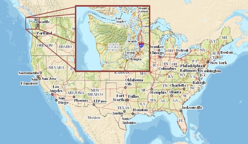
Figure 1: OLYMPEX Domain
(Image Source: https://pmm.nasa.gov/OLYMPEX)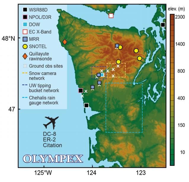
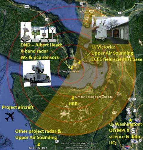
Figure 2: OLYMPEX Field Locations, CAX1 radar noted by a white box
                     (Image Source: https://pmm.nasa.gov/OLYMPEX)

Instrument Description
This dataset contains measurements made by a dual polarization X-band “CAX1” portable
scanning radar that was located at the southern tip of Vancouver Island on the Canadian
Forces Base (CFB) Esquimalt Albert Head (AHD) military training area (lat: 48.38711667,
lon: -123.4780556) labeled as DND - Albert Head in Figure 3 and shown with radar
measurement extent. The CAX1 radar was placed to cover the northern lee-side of the
Olympic Mountains and the inland waters. This location had a direct line-of-sight to
Hurricane Ridge (HRR) on the Olympic Peninsula.

The CAX1 radar is a SELEX Meteor 60DX10 Dual-pol X-band radar with a 2.4m dish, a
portable, low-cost, active phased array radar that is capable of weather and target
detection. This radar has a maximum range of 100 km. The radar operated continuously
during of the field campaign from November 13, 2015 onwards. The radar scanning was
carried out with a scan strategy that had a 5 min repeat time. The series of scans in each
cycle were 5 vertical cross sections (range height indicator scans) centred on Hurricane
Ridge followed by 3 low level azimuthal scans (plan position indicator scans) on elevation
angles of 1,5, 2.5 and 5.0 degrees out to a range of 100 km. The radar can perform both Plan
Position Indicator (PPI) and Range Height Indicator (RHI) scans. A PPI scan is where the
radar holds the elevation angle constant, but moves the azimuth angle, while an RHI scan is
where the radar holds the azimuth angle constant, but moves the elevation angle. More
information about the CAX1 dual polarization X-band radar is available in Hudak et al.,
2016 and Drake et al., 2015.
Figure 3: CAX1 radar location and view with respect to other ECCC and University of
Washington OLYMPEX instruments
(Image Source: Hudak et al., 2016)
Investigators
David Hudak
Environment and Climate Change Canada (ECCC)
King City, Ontario, Canada
Peter Rodriguez
Environment and Climate Change Canada (ECCC)
Toronto, Ontario, Canada
Vlado Stajanovic
Environment and Climate Change Canada (ECCC)
King City, Ontario, Canada
Sudesh Boodoo
Environment and Climate Change Canada (ECCC)
King City, Ontario, Canada
Norman DonaldsonEnvironment and Climate Change Canada (ECCC)
King City, Ontario, Canada
Robert Reed
Environment and Climate Change Canada (ECCC)
King City, Ontario, Canada
Data Characteristics
The GPM Ground Validation CAX1 Radar ODIM format OLYMPEX data files are available in
ODIM HDF-5 format at a Level 2 data processing level. More information about the NASA
data processing levels are available on the NASA Data Processing Levels website. Table 1
shows the characteristics of the data file.
Table 1: Data Characteristics
Characteristic Description
Platform Ground station
Instrument Dual-pol X-band radar
Projection n/a
Spatial Coverage N: 49.285, S: 47.489, E: -122.580, W: -124.376 (Washington)
Spatial Resolution 0.4 - 1.0 km
Temporal Coverage November 14, 2015 - April 1, 2016
Temporal Resolution 5 minutes
Sampling Frequencymm Two-digit minute in Z
Scan type: BIRDBATH, RHI, or VOL. Refer to Table 3 for more
***
information about these scan types
.h5 Opera Data Information Model (ODIM) HDF-5 format
.png Portable Network Graphics format
Data Format and Parameters
The GPM Ground Validation CAX1 Radar ODIM format OLYMPEX dataset consists of ODIM
HDF-5 data files containing observations from 5-minute scans providing radar parameters,
such as reflectivity, Doppler velocity, and correlation coefficient, for the time period
November 14, 2015 through April 1, 2016. Table 4 lists and describes these radar
parameters in the data file.
Table 3: Scan Types
Range Angular
Fixed Angle Max range
Scan Type resolution resolution
[Deg] [km]
[km] [km]
VOL PPI* 1.5, 2.5, 5.0 0.125 1.0 100
176.0, 178.5,
RHI RHI** 181.0, 183.5, 0.125 0.4 100
186.0
BIRDBATH PPI* 90.0 0.125 1.0 10
*PPI: Plan Position Indicator, which is where the radar holds the elevation angle constant, but
changes the azimuth angle to 2 positions
**RHI: Range Height Indicator, which is where the radar holds the azimuth angle constant, but
moves the elevation angle to 5 positions
Table 4: Data Fields
Field Name Description Unit
VEL Doppler velocity m/s
WID Doppler width m
Differential
ZDR dB
reflectivity
Correlation
RHOHV -
coefficient
Signal Quality
SQI -
Index
DBZ Reflectivity dB
PHIDP Differential phase dB
Differential phase
KDP dB
shift
Algorithm
Due to precipitation, the radar radiation and differential reflectivity are attenuated. The
Dual-Pol based Attenuation Correction (DPATC) algorithm is used to correct the reflectivityvalues for rain attenuation. The algorithm is applied to both the PPI and RHI scans. More information about the DPATC algorithm is provided in the DPATC – Dual-Pol based Attenuation Correction documentation. Quality Assessment The CAX1 radar had an absolute up-time of about 96.7% without any significant technical difficulties (less than 0.2%). When there was an outage, it was related to shutdowns for safety during on-site activities. In theory, the radar reflectivity value of a horizontal view of light raindrops should be 0.0, as well as appear spherical. To remove the possible effect of radome wetting, times where the precipitation rate was >0.01 mm/h were not included in the calculation of a daily mean radar reflectivity bias. This radar reflectivity bias was determined to be 0.75 dB for the entire dataset, where there was no significant day-to-day variation of the overall radar reflectivity bias. Also, no radar reflectivity bias correction was applied to this dataset. More information about the quality of these data are available in the CAX1 ZDR bias PI documentation. Software These data are in ODIM HDF-5 format. The OPERA Data Information Model for HDF-5 is a European type of data storage and exchange for radar data. To understand the organization of the format of these data files, refer to the EUMETNET OPERA weather radar information model for implementation with the HDF5 file format description document. The hierarchical nature of these data files are similar to files or directories on a hard-drive, where the actual metadata are stored as ‘attributes’ within ‘groups’. Instructions on how to plot and view these data are available on wradlib’s web page under ‘HDF5 OPERA HDF5 (ODIM_H5). Known Issues or Missing Data It was a significant challenge to mitigate clutter in the radar data, including severe orography of the Olympic Peninsula and sea clutter and ship traffic in the Juan de Fuca Strait. Because of the orographic conditions of the area, the CAX1 radar could only take measurements on the lee side of the Olympic Mountains; however, there were still a number of precipitation events on the lee side of these mountains. More information about the known issues of these data can be found in Hudak et al., 2016. References Drake, Peter R., Jacqueline Bourgeois, Anthony P. Hopf, Francis Lok, and David McLaughlin (2015): Dual-polarization X-band phased array weather radar: Technology update. IEEE Xplore, 2014 International Radar Conference, 1-6. doi: https://doi.org/10.1109/RADAR.2014.7060423
Hudak, David, Peter Rodriguez, Norman Donaldson, and Daniel Kirshbaum (2016):
OLYMPEX Canada.
https://ams.confex.com/ams/17Mountain/webprogram/Paper296448.html

Related Data
The CAX1 radar data are processed by different groups using a variety of formatting: ODIM,
RB5, and Cfradial. The Cfradial and RB5 data will also available from GHRC soon.

CAX1 radar was located at the southern tip of Vancouver Island on the Canadian Forces
Base (CFB) Esquimalt Albert Head (AHD) military training area along with other weather
instruments and a parsivel and pluvio instrument. The data from these instrument are:

Other instruments collected during the OLYMPEX field campaign are related to this dataset.
Other OLYMPEX campaign data can be located using the GHRC HyDRO 2.0 search tool.

Contact Information
To order these data or for further information, please contact:
       NASA Global Hydrology Resource Center DAAC
       User Services
       320 Sparkman Drive
       Huntsville, AL 35805
       Phone: 256-961-7932
       E-mail: support-ghrc@earthdata.nasa.gov
       Web: https://ghrc.nsstc.nasa.gov/

Created: February 12, 2018
You can also read