GUIDE TO THE TMBtent.com - TOUR DU MONT BLANC - TMBtent
←
→
Page content transcription
If your browser does not render page correctly, please read the page content below
TMBtent.com

   GUIDE TO THE
TOUR DU MONT BLANC
Welcome

Your adventure starts now!
  Welcome to the TMBtent Guide to The Tour du Mont Blanc! The TMB is an unforgettable trek
  however you approach it, but you’ll get the most out of your experience if you plan ahead.

  This guide will give you the tools to plan your perfect Tour du Mont Blanc adventure. In addition
  to in-depth information for every stage of the trek, we’ve also included sections on logistics,
  packing, and detailed navigation instructions that accompany our custom GPS files. You can
  print the entire guide or individual topics as needed. You can also download it to your mobile
  phone for easy access on the trail.

  We created this guide to reflect the insights, experience, and updates that we’ve gained from the
  past several years of running our website and diving into all things TMB. We feel confident that
  our guide has the most accurate and up-to-date information available and that it will be an
  invaluable resource for your trek.

  We are so excited that you’ve decided to hike the Tour du Mont Blanc and we know that with the
  right preparation you will have an incredible trip. Thank you for letting us be part of the process.

  Sincerely,

                     As passionate hikers and travelers, we've made it our goal to empower fellow trekkers
                     with all of the information they need to have their best TMB experience.

                     We scour the guidebooks, connect with accommodation providers, and compile tips
                     from other hikers in order to give you the most current, straightforward, and
                     accessible information possible. Happy trails!

 Emily & Ian
Disclaimer:

Everything presented here is for entertainment and informational purposes only, distributed on an as is basis with no
warranties. TMBtent, LLC makes no representations as to accuracy, completeness, currentness, suitability, or validity of
any information in this guide and will not be liable for any errors, omissions, or delays in this information or any losses,
injuries, or damages arising from its display or use. All information is provided on an as-is basis.

Copyright:

All maps included in this guide are copyright © OpenStreetMap contributors and © TMBtent, LLC.

All other information is copyright © TMBtent, LLC.

All rights reserved.
Contents
1
    About the TMB
     A quick overview of the hike, key stats, and what to expect along the route.

2
    Itineraries & Routes
     A summary of each stage and accommodation options for the classic 11-day
     TMB itinerary. In addition, we’ve included itineraries for 9-day and 12-day
     treks.

3
    Logistics
     Essential information about getting to and from the TMB, luggage storage,
     and rest days.

4
    Packing for the TMB
     Our tried-and-true gear list for conquering the TMB. The printable format
     makes packing a breeze!

5
    How to Navigate on the TMB
     Learn how to utilize the custom GPS files included with this guide to navigate
     using your smartphone.

6   Training Plan
     Get in shape for your TMB trek with our custom 15-week training plan!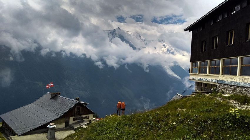
Section 1
About the TMB
About the TMB
The Tour du Mont Blanc is a 163-km loop trail that encircles the Mont Blanc Massif. Starting and
ending in France, it also takes walkers through Italy and Switzerland as it winds its way over
rugged mountain passes and through charming valleys.
163 Is it for you?
kilometers long
10,000
meters of elevation gain
11
days to complete
What’s it like?
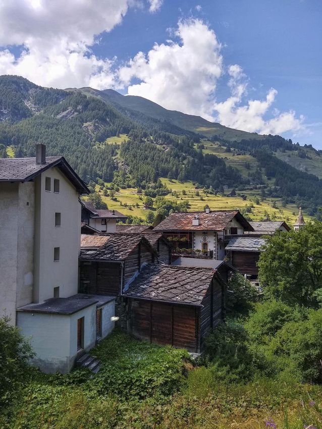
Passing through the many picturesque villages along the route is a major highlight of the TMB. If you
want a hike in which you can absorb Alpine culture and indulge in excellent wine and cheese at frequent
intervals, you’ll love the TMB. However, if you want to feel far from civilization and alone in nature, the
TMB might not be your best bet.
How hard is it?
If you are reasonably fit and have some backpacking experience, you should be well suited to the
physical challenges of the TMB. It is a tough trek that involves long, steep ascents and descents on
nearly every stage, but it isn’t too technically demanding. Attempting to complete the entire route in
less than 11 days will significantly increase the difficulty of the trek.
What can I expect in terms of food and lodging?
Facilities along the TMB can vary widely from place to place. They range from campgrounds and basic
mountain huts to luxurious hotels and guesthouses. Regardless of your style and budget, you have the
option of sleeping in a real bed and purchasing a hot meal at every stage of the route. Those wanting to
save money and increase their flexibility can self-cater most of their meals, restocking in the many
villages along the way.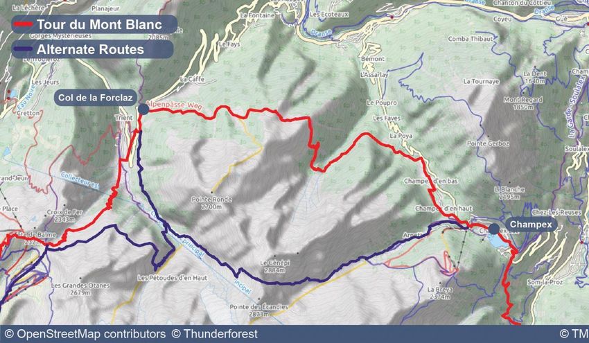
When to Hike
    The hiking season for the Tour du Mont Blanc lasts from
    late June through mid-September. Although you’ll find
    beauty anytime you go, we recommend hiking between
    mid-July and late August to have the best chances of
    good weather and to ensure that most of the mountain
    passes will be free from snow.

    The trail will be at its busiest during this time, so it’s a
    good idea to book your accommodation in advance as
    much as possible. A breakdown by month is below:

                               JUNE
    Early in the season, you are likely to encounter snow on the trail.
    Depending on the snow levels, there could be sections that will
    be impassible and you may need to reroute. Otherwise, expect
    cool evenings, bright sunny days, and less crowded trails. Keep in
    mind that most mountain refuges don’t open until late June.

                                 JULY
    Hikers could still encounter some snow along the trail, but the
    chance of significant snow cover will diminish as the month
    wears on. Expect beautiful warm days and abundant wildflowers.
    This is a popular month to hike.

                            AUGUST
    Another busy month on the trail, hikers can expect snow-free
    paths and warm, sunny weather. The end of August brings the
    Ultra Tour du Mont Blanc trail race. While the race is pretty cool,
    due to crowds and logistics, we recommend you try to avoid
    hiking during the UTMB.

                        SEPTEMBER
    Expect shorter days and increasingly chilly weather. This is a
    beautiful time to be on the trail and less crowded, although
    some accommodation providers may be closed for the season.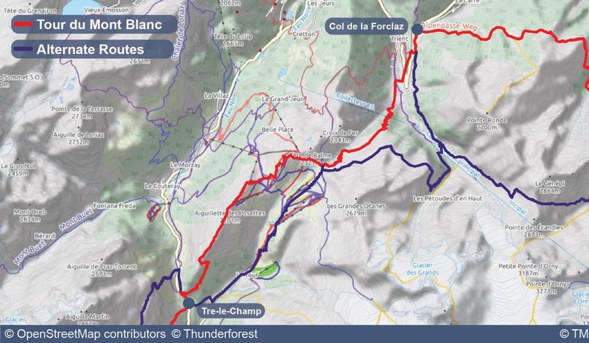
Section 2
Itineraries & Routes
TMB Basics
              Accommodation & Reservations
There is no shortage of excellent accommodation options along the Tour du Mont Blanc.
The villages and towns along the route have a wide variety of hotels, gites, and auberges.
These will suit almost any style, from more luxurious hotels to simple bunk rooms catering
to the budget traveler.

Of course, many of the stages of the TMB don’t end in villages, but rather at spectacular
mountain huts. For those unfamiliar with trekking in the Alps, be assured that these
mountain huts will be a highlight of your trip.

It is essential that you make reservations for any refuges/mountain huts you plan to stay
at on the TMB. Book as early as possible, as refuges can fill up for peak season months in
advance. The best place to start when making reservations is the official Tour du Mont
Blanc website. The same goes for any hotels, gites, or auberges. We always recommend
securing your reservation as far in advance as possible to avoid disappointment.

                               Food and Drink
One of the many wonderful things about the Tour du Mont Blanc is that you don’t need to
worry about carrying 11 days’ worth of food in your pack. The trail passes through many
towns and villages along the way, making resupply easy.

Additionally, all of the huts along the route serve excellent meals and most offer the option
of purchasing a packed lunch for the following day.

For budget travelers, it is possible to self-cater and keep your food and drink costs quite
reasonable. If you want to self-cater, we’d recommend you bring your own camp stove and
cooking equipment. There are several outdoor stores in Chamonix that sell stove fuel.

All of the hotels, gites, and campgrounds provide potable water. You will pass through
many villages with public drinking fountains, but make sure to plan ahead and carry 2-3
liters of water each day. Due to the presence of agricultural activity near large swaths of
the trail, we do not recommend drinking any water from natural streams without filtering
it first.

                                     Guidebooks
While this guide will certainly provide you with all the information you need to have a
great TMB adventure, we still recommend bringing a physical guidebook with you.

We love this Tour du Mont Blanc: Complete Two-Way Trekking Guide published by
Cicerone Trekking Guides. The author, Kev Reynolds, is extremely knowledgeable about
the Alps and the TMB in particular.
Which Direction to Hike
  The TMB is traditionally hiked in the anticlockwise direction beginning in the French town of Les Houches, adjacent to
  Chamonix. It is also possible to walk the route in the clockwise direction, and trekkers headed this way typically start
  in the Swiss town of Champex-Lac. All of the itineraries included in the guide are written for hikers travelling
  anticlockwise, but can be easily reversed if needed.

  Below we’ve outlined some pros and cons of hiking in each direction.

                                                                                                  Anticlockwise
                                                                                               Starts in Les Houches, France
                                                                     PROS

                                                                      ●     Follows the classic route; good if you’re a sucker for
                                                                            tradition.
                                                                      ●     Begins near Chamonix, which is easier to access from
                                                                            the Geneva Airport than Champex.
                                                                      ●     Rewards hikers with jaw-dropping views of Mont
                                                                            Blanc on the final stage.

                                                                     CONS

                                                                      ●     More people hike in this direction, so the trail could
                                                                            feel more crowded throughout the day.

Clockwise
Starts in Champex, Switzerland
PROS

 ●     Fewer hikers walking in the same direction as you.
 ●     The first few stages are a bit mellower, allowing you to get
       acclimated before tackling the tougher sections.
 ●     You’ll meet different people at each stop along the way.

CONS

 ●     You’ll pass a large wave of people walking in the opposite
       direction each day, which can get tight on narrow trails.
 ●     Champex (your starting point) has fewer amenities and is
       less conveniently connected by public transport than Les
       Houches. If you want to start in Les Houches and hike
       clockwise, be warned that the first day involves a very
       strenuous climb, which could be a major shock to the
       system.
Selecting Your Itinerary
The Tour du Mont Blanc is traditionally hiked over the course of 11 days, which is a
great pace for most hikers. However, there are certainly those who will want to
tackle the trail in fewer days or extend their hike over two weeks or more to really
savor their time in the Alps.
Whatever length you choose, be sure to consider your personal abilities, how
much time you’ll have, and what you want your typical days on the TMB to look
like.
Given the amount of accommodation options on the Tour du Mont Blanc, your
itinerary possibilities are virtually endless!
In the following pages of this guide we’ve included three itineraries that we believe
will suit the vast majority of trekkers. Take a look at each of the itineraires and use
these general guidelines when thinking about how many days you’ll need to
complete the TMB:
9 days
Fast pace (8 – 10 hours of hiking each day)
The 9-day itinerary is only recommended for experienced hikers who have an
excellent sense of their abilities. There are several very long days that have
significant elevation gain and loss.
11 days
Average pace, without a rest day (6-8 hours of hiking each day)
This is the standard Tour du Mont Blanc itinerary. Spreading the trek across 11
days allows walkers to enjoy their hike while still being plenty challenged.
12 days
Allows you to savor the final miles (4 - 8 hours of hiking each day)
Similar to the 11-day itinerary, but this option splits the final stage into two days.
This allows hikers to slow down and enjoy some of the TMB’s best scenery, and it
breaks up a long, knee-crushing descent.
Note: This Guide includes GPS data for all three itineraries as well as all of the popular
alternate routes on the Tour du Mont Blanc. This makes it easy to change your mind or
create your own custom itinerary.Itinerary & Route
11-day Tour du Mont Blanc - Main Itinerary
Day Start Finish Distance (km) Elevation Gain (m) Elevation Loss (m)
1 Chamonix Les Contamines 16.75 1,112 902
2 Les Contamines Les Chapieux 18.72 1,440 1,024
3 Les Chapieux Rifugio Elisabetta 13.87 1,079 480
4 Rifugio Elisabetta Courmayeur 16.07 603 1,536
5 Courmayeur Rifugio Bonatti 11.93 1,225 415
6 Rifugio Bonatti La Fouly 18.91 1,032 1,456
7 La Fouly Champex 14.90 729 860
8 Champex Col de la Forclaz 13.71 1,125 1,066
9 Col de la Forclaz Tre-le-Champ 14.14 1,112 1,229
10 Tre-le-Champ Refuge La Flegere 6.75 892 446
11 Refuge La Flegere Les Houches 16.78 969 1821Itinerary & Route
9-day Tour du Mont Blanc Alternate Itinerary
Day Start Finish Distance (km) Elevation Gain (m) Elevation Loss (m)
1 Chamonix Les Contamines 16.75 1,112 902
2 Les Contamines Les Chapieux 18.72 1,440 1,024
3 Les Chapieux Rifugio Maison Vieille 24.07 1,525 1,121
4 Rifugio Maison Vieille Rifugio Bonatti 17.57 1,169 1,101
5 Rifugio Bonatti La Fouly 18.91 1,032 1,456
6 La Fouly Champex 14.9 729 860
7 Champex Col de la Forclaz 13.71 1,125 1,066
8 Col de la Forclaz Tre-le-Champ 14.14 1,112 1,229
9 Tre-le-Champ Les Houches 23.53 1,600 2,010Itinerary & Route
12-day Tour du Mont Blanc Alternate Itinerary
Day Start Finish Distance (km) Elevation Gain (m) Elevation Loss (m)
1 Chamonix Les Contamines 16.75 1,112 902
2 Les Contamines Les Chapieux 18.72 1,440 1,024
3 Les Chapieux Rifugio Elisabetta 13.87 1,079 480
4 Rifugio Elisabetta Courmayeur 16.07 603 1,536
5 Courmayeur Rifugio Bonatti 11.93 1,225 415
6 Rifugio Bonatti La Fouly 18.91 1,032 1,456
7 La Fouly Champex 14.90 729 860
8 Champex Col de la Forclaz 13.71 1,125 1,066
9 Col de la Forclaz Tre-le-Champ 14.14 1,112 1,229
10 Tre-le-Champ Refuge La Flegere 6.75 892 446
11 Refuge La Flegere Refuge de Bellachat 9.89 859 595
12 Refuge de Bellachat Les Houches 6.89 137 1,27011-Day Itinerary Stage-by-Stage Guide
Stage One: Les Houches to Les Contamines

         OVERVIEW                                        DESCRIPTION
Distance: 17 km                      This stage is a perfect introduction to the TMB. It’s not
Elevation: +1,112 m, -902 m          too technical or demanding, yet it still gives walkers a
Estimated hiking time: 5 – 6 hours   decent challenge. You’ll start by climbing fairly steeply
                                     out of Les Houches and past a ski area before topping
                                     out at Col de Voza.
     ACCOMODATION
                                     From the Col, you’ll descend along dirt then paved
        OPTIONS                      roads while enjoying incredible views of the
                                     surrounding glaciers and aiguilles. Continue along the
High-End: Chalet-Hotel la            road through some very quaint hamlets, before veering
Chemenaz                             off onto a trail (pay attention-this is easy to miss). You’ll
                                     end this stage by walking along a mellow riverside path
Mid-Range: Hotel le Christiania      all the way to Les Contamines.

Budget: Chalet des Contamines
Stage Two: Les Contamines to Les Chapieux
OVERVIEW DESCRIPTION
Distance: 19 km Start this stage by passing by the Baroque chapel of
Elevation: +1,440 m, -1,024 m Notre Dame de la Gorge. From there, you’ll follow an
Estimated hiking time: 7-8 hours old Roman road steadily uphill before getting a break
when the trail levels out and passes through open
meadowland.
After that, prepare for another steep climb, much of it
on stony steps and scree, up first to the saddle of Col du
ACCOMMODATION Bonhomme, and then even higher to the Col de la Croix
OPTIONS du Bonhomme. Here you’ll find the Refuge de la Croix
du Bonhomme, which makes a great spot to enjoy a
Mid-Range: Chambres de Soleil break and small meal.
Budget/Mid-Range: Auberge de la Early in the season, it’s common to encounter snow on
Nova this section. Upon reaching the summit of Col de la
Croix du Bonhomme, begin your descent towards Les
Chapieux. On the way down, the trail begins as a steep
footpath, eases to join a jeep road for a bit, and then
finishes with steep zigzags through a pasture above Les
Chapieux.Stage Three: Les Chapieux to Rifugio Elisabetta
OVERVIEW DESCRIPTION
Distance: 14 km Choose to begin this stage with either a couple of miles
Elevation: +1,079 m, -480 m of road walking, or by short-cutting it on a bus to
Estimated hiking time: 5 – 6 hours Refuge des Mottets. From the refuge, you’ll begin a
relatively short and easy climb to the Col de la Seigne.
Reaching the Col is special for a few reasons. For one
thing, it marks the first of three international borders
ACCOMMODATION that you’ll cross on your trek. Standing at the top of the
Col, you can look back towards France while also gazing
OPTIONS ahead into Italy. Additionally, the wide-open views here
are downright marvelous. From Col de la Seigne, enjoy
Mid-Range: Rifugio Elisabetta a mellow descent to Rifugio Elisabetta.Stage Four: Rifugio Elisabetta to Courmayeur
OVERVIEW DESCRIPTION
Distance: 16 km As indicated by the elevation statistics, this stage is
Elevation: +603 m, -1,536 m dominated by a very long and steep descent into
Estimated hiking time: 5 – 6 hours Courmayeur. Before beginning that section, however,
you’ll cross through the expansive Vallon de la Lee
Blanche, where Lac Combal reflects the magnificent
surrounding peaks. From there, you’ll climb for awhile on
ACCOMMODATION an undulating path to reach Col Checrouit, where the
OPTIONS path begins its long downhill trajectory.
After passing a few ski areas (options to take the cable
High-End: Maison La Saxe
car down may be available), you’ll complete numerous
switchbacks through the woods until you reach the
Mid-Range: Hotel de la Telecabine
quaint town of Dolonne. Walk through the town of
Dolonne and cross the river to enter Courmayeur. Enjoy
Budget: Rifugio Bertone
a wide arrange of excellent food and luxurious
accommodation in Courmayeur. This is also a great place
to take a rest day.Stage Five: Courmayeur to Rifugio Bonatti
OVERVIEW DESCRIPTION
Distance: 12 km The views along this stage are some of the most
Elevation: +1,225 m, -415 m spectacular of the entire walk, but you have to earn
Estimated hiking time: 5 hours them with a very steep climb at the outset. You’ll enjoy
the satisfaction of watching Courmayeur grow ever
smaller down below you as you zigzag your way up the
hillside to Rifugio Bertone. From the Rifugio, you’ll
enjoy an undulating, mellow walk with unparalleled
ACCOMMODATION views of Col de la Seigne, Aiguille Noire, Mont Blanc
OPTIONS and the Grandes Jorasses.
It’s an incredible experience to look back and see Col de
Budget: Rifugio Bonatti
la Seigne far in the distance, knowing you’ve traversed
such an expanse in just a few short days with your own
two feet. The beautiful views continue to abound all the
way until you reach Rifugio Bonatti, an atmospheric
and memorable place to spend the night.Stage Six: Rifugio Bonatti to La Fouly
OVERVIEW DESCRIPTION
Distance: 19 km This stage rewards hikers with another border crossing
Elevation: +1,032 m, -1,456 m and more tremendous views. The walk begins with a
Estimated hiking time: 6-7 hours relatively flat path that crosses a lovely hillside.
Eventually, you’ll descend into Val Ferret (the Ferret
Valley) before beginning a steep climb past Rifugio
Elena and up further until you finally reach the Grand
Col Ferret.
ACCOMMODATION
OPTIONS At the top of the pass, you’ll enjoy your first views of
Switzerland as well as phenomenal views of majestic
peaks in every direction. It’s all downhill from there,
High-End: Hotel Edelweiss
much of which is pretty manageable, save for a few
steep sections. There’s a rather uninspiring stretch of
Mid-Range: Auberge des Glaciers
road walking at the very end of the day, but the
charming town of La Fouly makes it all worth it.
Budget: Chalet le DolentStage Seven: La Fouly to Champex
OVERVIEW DESCRIPTION
Distance: 15 km All of the guidebooks will tell you that this is the easiest
Elevation: +729 m, -860 m day of the TMB (which is technically true), but don’t
Estimated hiking time: 4-5 hours expect this stage to be completely effortless.
Sometimes the “easiest” days can end up feeling really
tough if we go into them with too cavalier a mindset.
The first two thirds of this stage are quite mellow
ACCOMMODATION indeed; you’ll wind your way gently downhill through a
OPTIONS quintessential Swiss valley filled with small farms and
picturesque hamlets.
High-End: Hotel Splendide
A substantial climb to Champex waits for you at the end
of the stage, however. Even though it really is much less
Mid-Range: Hotel Ptarmigan
strenuous than the ascents of previous stages, it can be
a shock to the body at the end of the day. Fortunately,
Budget: Pension en Plein Air
the trail stays in the shade for much of the way up, and
you’ll also get to enjoy the many whimsical wooden
sculptures that are interspersed throughout the woods.Stage Eight: Champex to Col de la Forclaz
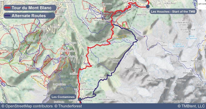
OVERVIEW DESCRIPTION
Distance: 14 km On stage 8, the main TMB route follows an undulating
Elevation: +1,125 m, -1,066 m path to the Alp Bovine and then descends to Col de la
Estimated hiking time: 4-5 hours Forclaz, but there are quite a few options to consider
here.
The Fenetre d’Arpette route is a popular variant for
those seeking challenge and adventure. With either
ACCOMMODATION route, you’ll also have a few options to choose from
OPTIONS when it comes to your stopping point.
For a shorter day, you can stop at Hotel de la Forclaz or
High-End/Mid-Range: Hotel de la
you can continue on further to either Le Puety or
Forclaz
Trient. There isn’t a clear “best” choice for what to do
on stage 8, but it is important to think about what is
High-End/Mid-Range: Auberge du
best for you in terms of challenge, distance, and
Mont Blanc
accommodation.
Budget: Refuge du Le PeutyStage Nine: Col de la Forclaz to Tre-le-Champ
OVERVIEW DESCRIPTION
Distance: 14 km This stage isn’t without it physical demands, gaining and
Elevation: +1,112 m, -1,229 m losing quite a bit of elevation over a relatively short
Estimated hiking time: 5-6 hours distance. While most of the climb maintains a grade
that isn’t crazy steep, the descent is another story. But
even if you don’t love the arduous nature of stage 9,
you’ll almost certainly be smitten by the scenery.
ACCOMMODATION Not only does summiting Col de Balme mean you’ll
OPTIONS celebrate your third and final border crossing (back into
France), but you’ll also get incredible views of Mont
Blanc, returning to the panorama for the first time in
High-End: Les Grands Montets
several days. Seeing Mont Blanc again and being back
on French soil will likely remind you that your trek is
Budget/Mid-Range: Auberge la
nearing its end. Make sure to savor the final two stages
Boerne
of this incredible experience!
Budget/Mid-Range: Gîte Le
MoulinStage Ten: Tre-le-Champ to La Flegere
OVERVIEW DESCRIPTION
Allow yourself to sleep in on this stage, as you’ll have just a short
Distance: 7 km walk ahead of you. Better yet, get to Refuge la Flegere early and
Elevation: +892 m, -446 m enjoy a walk to the nearby Lac Blanc and a meal or beverage at
Estimated hiking time: 4 hours the refuge. The final two days of the TMB follow the Grand
Balcon Sud, a balcony trail with unrivaled views of Mont Blanc
and the surrounding peaks.
Instead of being famous its vistas, however, stage 10 is perhaps
ACCOMMODATION better known as the “ladder stage.” To reach the high point of the
day, you’ll need to climb a series of ladders, catwalks, and
OPTIONS platforms that go on for longer than you might expect. If you
don’t have experience with this kind of thing and you also have a
Mid-Range: Refuge la Flégère fear of heights, we recommend taking the Col des Montets
variante.
Mid-Range: Refuge du Lac Blanc The variante route takes about the same amount of time and still
has great views. If you choose to conquer the ladders, make sure
you do so in good weather conditions, use caution and common
sense, and you’ll be just fine. You might even find the ladders to
be pretty fun! Upon reaching Refuge la Flegere, join in the
festive revelry with your fellow hikers marking their final night
on the trail.Stage Eleven: La Flegere to Les Houches
OVERVIEW DESCRIPTION
The final stage of the TMB is a big one in every way. Even though
Distance: 17 km it’s dominated by downhill walking, the physical demands
Elevation: +969 m, -1,821 m shouldn’t be overlooked. Start the walk on a very mellow uphill
Estimated hiking time: 6-7 hours grade, before beginning a steeper climb past a ski area until
reaching Col du Brevent. Take in the scenery (and catch your
breath) here, but keep in mind that the best is yet to come. Climb
further on more rugged terrain until you reach the
ACCOMMODATION almost-summit of Le Brevent (you can take a 5-minute detour to
OPTIONS get to the actual top if you’d like).
Chamonix:
At this point, get ready to be completely overwhelmed by the
High-End: Hotel Le Morgane views. From Le Brevent you’ll have an unobstructed and totally
breathtaking vantage point from which to take in the entire
Mid-Range: Chamonix Lodge Mont Blanc range. Take time to study every intricate glacier and
craggy spire before finally tearing yourself away to make your
Budget: Le Chamoniard Volent way down towards Les Houches.
Les Houches: Fortunately, you’ll continue to enjoy the scenery for awhile as
you descend on a very long and very steep path. As you near Les
High-End: Chalet Hotel du Bois Houches, the trail enters the woods where it passes a zoo and
the large Christ Roi statue. Finally, the path spits you out onto
Mid-Range: RockyPop Hotel the road and perhaps the least scenic part of Les Houches. Keep
walking to reach the more charming part of town, then stop and
Budget: Gite Michel Fagot toast to your remarkable accomplishment!Section 3 Logistics
Stage Zero: Les Houches or Chamonix

     ACCOMODATION                                   DESCRIPTION
        OPTIONS                  The Tour du Mont Blanc officially begins in the town of
                                 Les Houches, which is about 15 minutes by bus from
Chamonix:
                                 Chamonix. The bus is easy to use and runs frequently,
                                 so you can stay in either Chamonix or Les Houches the
High-End: Hotel Le Morgane
                                 night before starting your trek.
Mid-Range: Chamonix Lodge
                                 Chamonix offers a wide selection of accommodation,
                                 shops, and restaurants, and many TMB hikers enjoy
Budget: Le Chamoniard Volent
                                 experiencing this iconic mountain town.

                                 Les Houches has all of the basic amenities, but it is
Les Houches
                                 much small and quieter than Chamonix. Its village
                                 charm and proximity to the TMB makes it a great
High-End: Chalet Hotel du Bois
                                 choice.
Mid-Range: RockyPop Hotel

Budget: Gite Michel Fagot
Getting to Chamonix from the Geneva Airport
THE BASICS
Cost: €19 - €40
Duration: 1.5 - 2.5 hours
Transport type: Bus or private shuttle
Advance booking: Required for all options
The vast majority of walkers will get to the start of the Tour du Mont Blanc by first flying into
the Geneva Airport (GVA).
There are frequent flights to Geneva from the rest of Europe as well as a good number of
flights from the U.S. Most U.S. flights arrive early in the morning, leaving you with ample time
to get to Chamonix that same day.
Once you’ve landed in Geneva, you’ll have several options for getting to Chamonix, outlined
below:
● OuiBus: We found this to be the cheapest option and would highly recommend
OuiBus. The service departs directly from the Geneva Airport and will take you to the
Chamonix Sud bus station, in the heart of Chamonix.
● AlpyBus: AlpyBus runs a door-to-door transfer service from the Geneva Airport to
hotels in the Chamonix Valley. It is more costly than OuiBus, but also more convenient
since they’ll drop you directly at your hotel.
● Mountain Drop-offs: Similar to AlpyBus, Mountain Drop-offs runs a door-to-door
transfer service for walkers arriving in Geneva. Very highly rated.
All of these options can also transport you back to the Geneva Airport at the end of the
TMB. Most offer discounts for booking a return ticket.Getting to Les Houches from Chamonix
THE BASICS
Cost: €2 - €3
Duration: 15 - 20 minutes
Transport type: Bus or train
Advance booking: Not required
Many walkers will opt to stay at least one night in Chamonix before and after hiking the Tour
du Mont Blanc. While Les Houches is a lovely town, there is no denying that Chamonix has
more services and certainly more accommodation options.
Luckily, the Chamonix Valley has excellent public transportation links, and it is a breeze to get
to Les Houches and the start of the TMB from just about anywhere in the valley.
Bus
If you’re staying in Chamonix, you’ll want to make your way to the Chamonix Sud bus station.
Busses depart from the Chamonix Sud bus station every 30 minutes for Les Houches. You can
find updated service schedules on the Chamonix Bus website. Once in Les Houches, get off at
the ‘Les Houches Mairie’ stop located in the center of the village.
Train
Most hikers will find that the bus is a more convenient choice for getting from their
accomodation to the trail. However, the Mont Blanc Express train route also connects
Chamonix and Les Houches via a scenic 15-20 minute ride. Bear in mind that it is a 10-minute
uphill walk from the Les Houches train station to the start of the TMB.
Carte d’Hote
Make sure to ask your accommodation provider in Chamonix for this Guest Card. As a benefit
of paying the mandatory tourist tax added onto the cost of your lodging, you’ll receive a
complimentary Carte d’Hote. This card allows you to ride the bus and train within the
Chamonix Valley (including getting to the start of the TMB in Les Houches) free of charge. The
card is only valid for the length of your stay, from check-in through check-out.Where to Stay Before and After the TMB
Chamonix
Hotel Le Morgaine – Spacious rooms, friendly staff, and an excellent
location.. Room rates are also quite reasonable.
Auberge du Manoir – Known for their friendly staff, beautiful rooms, and
great location, the Auberge du Manoir is a great option in Chamonix. If you
have a booking before and after the TMB, they’ll store your luggage for
free!
Hôtel Le Refuge des Aiglons – This hotel is located adjacent to the
Chamonix Sud bus station, making it an ideal location for the night you
arrive in or before you depart Chamonix. The hotel also offers free luggage
storage during your hike if you have a booking with them.
Les Houches
Hotel Les Campanules – Located just across the river from the town center
of Les Houches, Hotel Les Campanules gets great reviews for its
tremendous views and excellent food. It’s also a great budget option.
Rocky Pop Hotel – Located just outside of Les Houches, the Rocky Pop
hotel has stellar reviews for its funky style and friendly staff.
Luggage Storage
Many walkers will be traveling with more luggage than they might want to
carry for the entire TMB.
Unfortunately, there are no luggage storage facilities at the train station
in Chamonix. Walkers can store their extra luggage at the Auberge du
Manor, which charges €2 per day (free if you stay there before and after
your hike).
Other hotels and accommodation may store your baggage if you have a
reservation before and after you walk, but you’ll want to confirm this
ahead of time.Rest Day Options
Many walkers choose to break up the long days of trekking on the TMB by taking a rest day along the way. If
you have the time, we highly recommend taking a rest day as it will give your body a chance to recharge and
also allow you to explore one of the wonderful villages or towns along the route. Here are your best options:
Courmayeur
Courmayeur is understandably the most popular place for a rest day on the
TMB. While it isn’t exactly the halfway point, you’ll have already crossed
several major passes and your feet may be begging for a break.
Courmayeur is also the largest town you’ll encounter on the TMB, making
for an easy place to stock up on supplies and enjoy a shower and bed. Our
lodging recommendations for Courmayeur are below:
Hotel Maison La Saxe – Located just up the valley from Courmayeur, this
small hotel offers an incredible breakfast spread and beautiful rooms. Book
early as they only have six rooms!
Cresta Et Duc Hotel – Centrally located with free breakfast. What’s not to
love?!
La Fouly
La Fouly is just past the halfway point of the TMB, so naturally it makes a
good rest day spot. The town is small so there won’t be as much to do as in
Courmayeur, but it is a beautiful location nevertheless. Check out our
favorite spot in La Fouly:
Maya Joie – A highly rated auberge with a variety of room types and free
WiFi.
Champex
Champex is a lovely Swiss town located on a pristine mountain lake. Most
walkers who are traveling counterclockwise will arrive in Champex at the
end of their seventh day and will be very ready for a break! Champex offers
many services, accommodation options, and more to do than La Fouly. Our
lodging recommendation for Champex:
Hôtel du Glacier – Get a room with a balcony to enjoy the stunning views!Section 4 Packing for the TMB
Essential Gear
 Making smart choices about what to pack (and what to leave behind) is a key part of setting yourself up for a
 successful and enjoyable TMB experience. It’s simple: the heavier your pack, the harder your effort.
 However, with a little thoughtful planning, you can keep your pack weight manageable while still ensuring
 you have everything you need to be comfortable both on and off the trail.

     Footwear                        Layers                    Backpack                   Trekking Poles
Traditional hiking           Weather conditions           Make sure you                These are a total
boots, hiking shoes, or      vary widely in the Alps;     complete several hikes       game-changer on a
trail runners will all       you’ll likely experience     with your bag packed         tough trek like the Tour
work for the conditions      relentless heat, rain or     the same way and with        du Mont Blanc. You (and
on the TMB. Bring a          snow, and driving winds      the same weight you’ll       your knees) will be so
pair of boots or trail       all in the course of your    carry on the TMB. Just       glad to have them on
shoes that you know          trek-or even all in the      like shoes, backpacks        steep and loose
from experience don’t        same day! Dressing in        need to be broken in,        sections. We
cause problems for           smart layers is essential    and your body needs to       recommend bringing
your feet. Ideally, you      for staying safe and         get used to the feeling      lightweight, telescoping
should put at least 30       comfortable on the           of wearing it for            poles that can be
miles on them in             TMB. We recommend            extended periods of          packed away for travel.
various terrains and         packing a lightweight        time. In terms of size,      Also, it is important to
weather conditions to        down jacket and rain         most hikers will need        hike with your poles
reduce the chance of         shell as your outer          between 25 and 45            while training, as it
running into issues on       layers, as well as long      liters. Don’t forget to      takes a bit of time to
the trail.                   and short sleeve merino      bring a pack cover to        learn how to use them
                             wool base layers.            protect against rain.        most effectively.

 How much should my pack weigh?
   There are several factors that influence how much is too much for any individual hiker.
   Considerations include:

     ●    How fast are you hoping to hike? Generally speaking, lighter=faster.
     ●    Have you completed a multi-day thru-hike with this specific backpack and this amount of
          weight before? If not, you should really try to keep it below 15lbs (including water!)
     ●    Are you injury-prone or do you have any chronic knee, hip, or back issues? If so, you need to
          make sure your backpack stays as light as possible.
     ●    One last rule of thumb: If you can’t fit everything in a 40L backpack or smaller, you have
          packed too much.
PACKING LIST
HUT GEAR PERSONAL GEAR MISC. GEAR
❏ Sleep sheet ❏ Multi-tool ❏ Guidebook
❏ Camping stove (optional) ❏ First-aid kit ❏ Ear plugs
❏ Backpacking pot (optional) ❏ Hydration bladder ❏ Camera
❏ Utensils (optional) ❏ Pack cover ❏ Unlocked phone
❏ Plate/Bowl/Mug (optional) ❏ Backpack ❏ Battery backup
❏ Stove fuel (optional) ❏ Trekking poles ❏ Biodegradable soap
❏ Lighter/waterproof matches ❏ Travel towel ❏ Travel adapter
❏ ___________________ ❏ Headlamp ❏ Plastic bags
❏ Sunscreen ❏ Digital watch
❏ Toilet paper ❏ Sleeping mask
❏ Microspikes
WOMEN’S CLOTHING MEN’S CLOTHING
❏ Underwear (3-4 pairs) ❏ Underwear (3-4 pairs)
❏ Socks (3-4 pairs) ❏ Socks (3-4 pairs)
❏ Sports bra (1) ❏ Long sleeve base layer (1)
❏ Long sleeve base layer (1) ❏ Short sleeve hiking shirt (1)
❏ Short sleeve hiking shirt (1) ❏ Hiking pants (1 pair)
❏ Leggings (1 pair) ❏ Running shorts (1 pair)
❏ Running shorts (1 pair) ❏ Down jacket
❏ Down jacket ❏ Rain jacket
❏ Rain jacket ❏ Hiking boots
❏ Hiking boots ❏ Sunglasses
❏ Sunglasses ❏ Gloves
❏ Underwire bra ❏ Hat
❏ Gloves ❏ Sandals/hut shoes
❏ Hat ❏ Buff
❏ Sandals/hut shoes ❏ Rain pants
❏ Buff ❏ __________________
❏ Rain pants ❏ __________________Section 5 How to Navigate on the TMB
Should I bring a map on the Tour du Mont Blanc?

Given that the Tour du Mont Blanc is a well marked trail, you shouldn't need to rely heavily on any of the
various paper maps that are available for the TMB. We believe that utilizing the offline GPS maps that
we'll cover in this section is the best way for most trekkers to navigate on the TMB.

However, you should still plan to bring a paper map with you. While technology has done a tremendous
amount to make navigating while hiking easier, there is simply no replacement for carrying a physical map
with you. If that iPhone you brought runs out of battery or you drop it in a puddle, you’ll be glad you had
your handy paper maps to rely on.

We recommend carrying the IGN 3630 OT Chamonix and IGN 3531 ET St-Gervais, as they provide a
detailed view of the TMB route. A weatherproof carrying case wouldn’t hurt to have either.

For those who may not need the 1:25,000 level of detail, IGN also publishes a 1:50,000 scale map of the
entire TMB.

You can find these maps at the following retailers or at any outdoors shop in Chamonix:
The Map Centre
Maps Company
How to turn your phone into a GPS

An offline mobile map of the Tour du Mont Blanc is one of the easiest ways to navigate while you’re on the
trail. You’ll simply open up your chosen GPS app (more on that in the next section) and be able to view
your exact location, the overall trail, alternate routes, and stopping points along the TMB. You can utilize
this to check that you are still on the route and know how far you've hiked at any given point along the
way.

We think this is far and away the most convenient way to navigate on the Tour du Mont Blanc and want to
help you successfully utilize offline mobile maps on your Tour du Mont Blanc trek. As part of this guide,
we've provided a corresponding GPS download that you can access with the method described below.
Keep reading to learn more about how your phone can work as a GPS and how we can help you feel
confident using this navigation method.

Using your phone as a GPS
Modern smartphones are incredible machines. You can send email, video chat with someone halfway
around the world, and check your bank account all with a swipe of your finger. Another great feature of
smartphones is their ability to act as a GPS device. You regularly use this feature when navigating with
Google Maps, Apple Maps, or other mapping software that comes standard on most phones these days.

The problem is your phone relies on having an internet connection in order to download the background
mapping data that needs to be displayed for you to know where you are. You see, the GPS in your phone
only provides a location point, but the really valuable data is the background map that shows the various
streets, businesses and even traffic conditions around you. Without an internet connection to show the
background map, your phone won't have anything to display. You'll only see sad blue dot floating on a
blank gray background.

Solving the background map problem
While the issue of a background map not displaying isn’t typically a problem in cities or towns where
ample cell phone service (and thus internet connectivity) exists, it can be a huge problem when you’re, say,
on top of a high mountain pass on the Tour du Mont Blanc without service. The solution? GPS Navigation
apps that allow for downloadable background maps. These apps allow you to select a predefined area, in
our case the entirety of the Tour of Mont Blanc, and download the background map to your phone.

This allows you to access the map data without a cell phone connection and still know exactly where you
are! Even though your phone is not connected to cell service or internet, the GPS will still work without
incurring any “roaming” charges.

In the next section we'll help you decide which GPS navigation app is best for you before providing
step-by-step instructions on how to utilize our custom GPS data on your phone.
Which GPS app should I use?

There are two main offline GPS navigation apps that we recommend for those hiking the Tour du Mont
Blanc: Maps.me and Gaia GPS.

The main difference between the two apps is that Maps.me is free to download and use, but has limited
base maps. On the other hand, Gaia GPS requires a $19.99 annual subscription to use but has superior
offline base maps and more robust navigational tools. Check out the comparison below to see how a
specific section of the Tour du Mont Blanc displays in each of the apps.

As you can see, Maps.me can easily display the route as well as location markers along the way. However,
the same section of trail displayed in Gaia GPS gives the user much more information such as adjacent
trails, topographic lines, and elevation shading.

For this reason, we highly recommend you invest the $20 to use Gaia GPS, although we certainly
understand those who prefer to use a free option. Instructions for downloading and accessing the GPS
data for the Tour du Mont Blanc for both Maps.me and Gaia GPS are included in the next section.
Using Gaia GPS for your Tour du Mont Blanc map
The instructions below provide a step-by-step guide for downloading and accessing the custom Tour du
Mont Blanc GPS data we’ve created in Gaia GPS. The first step is to download the .gpx or .kml file that
we have created for your chosen itinerary. These files were sent in your order confirmation email.

Step One - Download the Tour du Mont Blanc GPS file
A link for the GPS file is included in your order confirmation email. You’ll want to be sure to open the email
and download the .KML file directly onto your phone (as opposed to on another device) to simplify the
process. After completing the download you’ll be prompted to open the file in Gaia GPS, which you should
do.

Gaia GPS will then import the data and you should see the Tour du Mont Blanc route and waypoints for
your specific itinerary displayed on the map.
Step Two – Choose your map source
Next, you’ll want to select your base map. This will be the background map that you will eventually
download and use to navigate while hiking, even without cell phone service. There are tons of background
maps available for download, but we highly recommend the “Outdoor” layer for those hiking the Tour du
Mont Blanc. To choose this map source, simply select the layers icon in the top right corner and then
select ‘Outdoors’
Step Three – Navigate to the Tour of Mont Blanc and download your background map
Once you have selected the “Outdoor” base map, you’ll need to download the entire area of the Tour of
Mont Blanc. Remember, without downloading this data you’ll have no way to know your exact location on
the trail when you don’t have cell phone service. To download the map background data, follow the steps
below:

 1.   Navigate to the area of the Tour du Mont Blanc in Gaia GPS
 2.   Select the ‘Create’ button (circle with a plus sign in the upper right hand corner)
 3.   Select ‘Download Map’
 4.   Draw a rectangle with your finger that encompasses the entire Tour du Mont Blanc
 5.   Set the ‘Max Zoom’ to 17
 6.   Name your map ‘Tour du Mont Blanc’ and select ‘Save’
 7.   Allow the download to complete and you’re done! (you’ll want to be connected to WiFi for this)

 That’s it! Now you’re all set to navigate on the Tour du Mont Blanc like a pro with an offline GPS map in
 Gaia GPS. You can now zoom in on specific sections, view trail segments, and see all of the stopping points
 along the route!
Using Maps.Me for your Tour du Mont Blanc map
The instructions below show a step-by-step guide for downloading and accessing the custom Tour du
Mont Blanc GPS data we’ve created in Maps.me. Maps.me is an excellent free navigation app that allows
you to download offline background data.

The primary shortcoming of using Maps.me for navigation while trekking is the limited base map data.
You won’t find any topographic lines, terrain shading, or other helpful features. However, we know that
many trekkers will be just fine with Maps.me and you can’t beat the price!

Step One - Download the Tour du Mont Blanc GPS file
A link for the GPS file is included in your order confirmation email. You’ll want to be sure to open the email
and download the .KML file directly onto your phone to simplify the process. After completing the
download you’ll be prompted to open the file in Maps.me, which you’ll want to go ahead and do.

After opening the .KML file with Maps.me, the app will navigate to your current location and will also
display a message stating that your bookmarks have successfully been loaded. You’ll need to move the
map from your current location to the Tour du Mont Blanc and verify that you see the track and waypoints
displayed.
Step Two – Download the Tour du Mont Blanc background maps
Once you have successfully loaded the Tour du Mont Blanc GPS data, you’ll need to download the entire
area of the Tour of Mont Blanc as a base map in Maps.me. Remember, without downloading this data
you’ll have no way to know where exactly you are on the trail. To download the background map data in
Maps.me, follow the steps below:

 1.   Navigate to the area of the Tour du Mont Blanc in Maps.me
 2.   Zoom in on the trail until the app prompts you to download a map region
 3.   You’ll need to download four distinct regions in Maps.me to cover the entire TMB. They are:
        a.    Haute-Savoie
        b.    Savoie
        c.    Aosta Valley
        d.    Lake Geneva Region
 4.   Continue to zoom in on different segments of the trail until you have downloaded all four of these
      regions
 5.   Verify that you’ve downloaded all of the required base maps by navigating to the ‘Download Maps’
      menu.
 6.   Once you’ve checked that all four regions have been successfully downloaded you’re all done!
Step Three – Verify that you’ve downloaded the basemaps To verify that you’ve successfully downloaded all of the four required base map regions in Maps.me follow these steps: 1. Select the ‘Menu’ in the bottom right hand corner of the screen 2. Select ‘Download Maps’ 3. Verify that you have downloads in France, Italy, and Switzerland 4. Select each country and verify that you have the following four maps downloaded: 5. Haute-Savoie (France) 6. Savoie (France) 7. Aosta Valley (Italy) 8. Lake Geneva Region (Switzerland) That’s it! You’re all set to navigate on the Tour du Mont Blanc like a pro with an offline GPS map utilizing Maps.me. You can now zoom in on specific sections, view trail segments, and see all of the stopping points along the route!
Section 6
Training Plan
Your 15-Week TMB Training Plan
Use this training plan as a general guide to prepare for the TMB. Can’t do every exercise, miss a day, or need to make some substitutions? No problem! You’ll be just
fine on your trek, as long as you go into it with good health and a decent fitness base. Feel free to make adjustments to this plan to fit your unique circumstances.

Disclaimer: This training plan is not intended for the treatment or prevention of disease, nor is it a replacement for seeking medical treatment or professional nutrition advice. Do not start any
nutrition or physical activity program without first consulting your physician.

      Starting six months before the TMB, focus on building your base. Walk, run, hike, swim, and/or cycle for 30-60 minutes at least twice a week to
                                                            establish your cardio endurance.

  Weeks until               Monday                     Tuesday                 Wednesday                    Thursday                      Friday                 Saturday                 Sunday
    TMB

                       30 min Incline           Strength Workout:             30-60 min               Strength Workout:            30 min Cardio             Long hike or            Rest
                       Cardio                   3 sets each                   Cardio                  3 sets each                                            long walk (1.5
                                                                                                                                   OR                        hours)
                                                -Goblet squats (10                                    -Goblet squats (10
        15                                      reps)                                                 reps)
                                                                                                                                   Rest depending
                                                -Lunges (10 each leg)                                 -Lunges (10 each leg)        on how you feel.

                                                -45 second plank                                      -45 second plank

                       30 min Incline           Strength Workout:             30-60 min               Strength Workout:            30-60 min                 Long hike or            Rest
                       Cardio                   3 sets each                   Cardio                  3 sets each                  Cardio                    long walk (1.5
                                                                                                                                                             hours)
                                                -Goblet squats (10                                    -Goblet squats (10
                                                                                                                                   OR
                                                reps)                                                 reps)

                                                -Lunges (10 each leg)                                 -Lunges (10 each leg)        Rest depending
                                                                                                                                   on how you feel.
        14                                      -45 second plank                                      -45 second plank

                                                -Side lunges (8 each                                  -Side lunges (8 each
                                                leg)                                                  leg)

                                                -Step-ups (10 each                                    -Step-ups (10 each
                                                leg)                                                  leg)
Weeks until Monday Tuesday Wednesday Thursday Friday Saturday Sunday
TMB
30 min Incline Strength Workout: 30 min Incline Strength Workout: 30-60 min Long hike or Rest
Cardio 3 sets each Cardio 3 sets each Cardio long walk (1.5-2
hours)
-Goblet squats (10 -Goblet squats (10
OR OR
reps) reps)
-Lunges (10 each leg) 60 min Cardio -Lunges (10 each leg) Rest depending
on how you feel.
13 -45 second plank -45 second plank
-Side lunges (8 each -Side lunges (8 each
leg) leg)
-Step-ups (10 each -Step-ups (10 each
leg) leg)
30 min Incline Strength Workout: 30 min Incline Strength Workout: 30-60 min Long hike or Rest
Cardio 3 sets each Cardio 3 sets each Cardio long walk
(2 hours)
-Goblet squats (10 -Goblet squats (10
OR OR
reps) reps)
-Lunges (10 each leg) 60 min Cardio -Lunges (10 each leg) Rest depending
on how you feel.
-45 second plank -45 second plank
12 -Side lunges (8 each -Side lunges (8 each
leg) leg)
-Step-ups (10 each -Step-ups (10 each
leg) leg)Weeks until Monday Tuesday Wednesday Thursday Friday Saturday Sunday
TMB
60 min Incline Strength workout: 30 min Incline Strength workout: 30 min Cardio Long hike or Rest
Cardio 3 sets each Cardio 3 sets each long walk (2
OR hours)
-Goblet squats (10 -Goblet squats (10
OR
reps) reps)
Rest depending
-Lunges (10 each leg) 60 min Cardio -Lunges (10 each leg) on how you feel.
11 -45 second plank -45 second plank
-Side lunges (8 each -Side lunges (8 each
leg) leg)
-Step-ups (10 each -Step-ups (10 each
leg) leg)
60 min Incline Strength Workout: 60 min Cardio Strength Workout: 30 min Cardio Long hike or Rest
Cardio 3 sets of each 3 sets of each long walk (2-3
OR hours)
-Squats w/ overhead -Squats w/ overhead
press (10 reps, press (10 reps,
medium dumbells) medium dumbells)
Rest depending
on how you feel.
-Lunges (12 each leg) -Lunges (12 each leg)
-60 second plank -60 second plank
10
-Side lunges (10 each -Side lunges (10 each
leg) leg)
-Step-ups (10 each -Step-ups (10 each
leg) leg)
-hip bridges (10 reps) -hip bridges (10 reps)Weeks until Monday Tuesday Wednesday Thursday Friday Saturday Sunday
TMB
60 min Incline Strength Workout: 60 min Cardio Strength Workout: 30-45 min Long hike or Rest
Cardio 3 sets of each 3 sets of each Cardio long walk (2
OR hours) with
-Squats w/ overhead -Squats w/ overhead
OR weighted pack*
press (10 reps, press (10 reps,
medium dumbells)
45 min Incline medium dumbells)
Cardio Rest
-Lunges (12 each leg) -Lunges (12 each leg) depending on
9 how you feel.
-60 second plank -60 second plank
-Side lunges (10 each -Side lunges (10 each
leg) leg)
-Step-ups (10 each -Step-ups (10 each
leg) leg)
-hip bridges (10 reps) -hip bridges (10 reps)
30-45 min Strength Workout: 60 min Cardio Strength Workout: Rest Long hike or 45 minute
Cardio 3 sets of each 3 sets of each long walk (2 walk or hike
OR hours) with
-Squats w/ overhead -Squats w/ overhead
OR weighted pack
press (10 reps, press (10 reps,
medium dumbells)
45 min Incline medium dumbells)
Rest Cardio
depending on -Lunges (12 each leg) -Lunges (12 each leg)
8 how you feel.
-60 second plank -60 second plank
-Side lunges (10 each -Side lunges (10 each
leg) leg)
-Step-ups (10 each -Step-ups (10 each
leg) leg)
-hip bridges (10 reps) -hip bridges (10 reps)Weeks until Monday Tuesday Wednesday Thursday Friday Saturday Sunday
TMB
30-45 min Strength Workout: 60 min Cardio Strength Workout: Rest Long hike or 60 minute
Cardio 4 sets of each 4 sets of each long walk incline walk or
OR hike
-Squats w/ overhead -Squats w/ overhead
OR (Ideally 1,000
press (10 reps, press (10 reps,
medium dumbells)
45 min Incline medium dumbells)
meters
Rest Cardio elevation gain,
depending on -Lunges (12 each leg) -Lunges (12 each leg) 10-15km)
7 how you feel. with weighted
-60 second plank -60 second plank pack
-Side lunges (10 each -Side lunges (10 each
leg) leg)
-Step-ups (10 each -Step-ups (10 each
leg) leg)
-hip bridges (10 reps) -hip bridges (10 reps)
30-45 min Strength Workout: 60 min Cardio Strength Workout: Rest Long hike or 60 minute
Cardio 4 sets of each 4 sets of each long walk incline walk or
hike with
-Squats w/ overhead -Squats w/ overhead
OR (Ideally 1,000 weighted pack
press (10 reps, press (10 reps,
medium dumbells) medium dumbells)
meters
Rest elevation gain,
depending on -Lunges (12 each leg) -Lunges (12 each leg) 10-15km)
6 how you feel. with weighted
-60 second plank -60 second plank pack
-Side lunges (10 each -Side lunges (10 each
leg) leg)
-Step-ups (10 each -Step-ups (10 each
leg) leg)
-hip bridges (10 reps) -hip bridges (10 reps)Weeks until Monday Tuesday Wednesday Thursday Friday Saturday Sunday
TMB
30-45 min Strength Workout: 60 min Cardio Strength Workout: Rest Long hike or 60 minute
Cardio 4 sets of each 4 sets of each long walk incline walk or
hike with
-Squats w/ overhead -Squats w/ overhead
OR (Ideally 1,000 weighted pack
press (10 reps, press (10 reps,
medium dumbells) medium dumbells)
meters
Rest elevation gain,
depending on -Lunges (12 each leg) -Lunges (12 each leg) 10-15km)
5 how you feel. with weighted
-60 second plank -60 second plank pack
-Side lunges (10 each -Side lunges (10 each If you plan on
leg) leg) using new hiking
boots on the TMB,
-Step-ups (10 each -Step-ups (10 each start breaking
leg) leg) them in now.
-hip bridges (10 reps) -hip bridges (10 reps)
30-45 min Strength Workout: 60 min Cardio Strength Workout: Rest Long hike or Long hike or
Cardio 4 sets of each 4 sets of each long walk long walk
-Squats w/ overhead -Squats w/ overhead
OR (Ideally 1,000 (Ideally 1,000
press (10 reps, press (10 reps,
Rest medium dumbells) medium dumbells)
meters meters
depending on elevation gain, elevation gain,
how you feel. -Lunges (12 each leg) -Lunges (12 each leg) 10-15km) 10-15km)
with weighted with weighted
-60 second plank -60 second plank pack pack
4
-Side lunges (10 each -Side lunges (10 each
leg) leg)
-Step-ups (10 each -Step-ups (10 each
leg) leg)
-hip bridges (10 reps) -hip bridges (10 reps)Weeks until Monday Tuesday Wednesday Thursday Friday Saturday Sunday
TMB
Rest Strength Workout: 60 min Cardio Strength Workout: Rest Long hike or 60 min Incline
3 sets of each 4 sets of each long walk Cardio
-Squats w/ overhead -Squats w/ overhead
(Ideally 1,200
press (10 reps, press (10 reps,
medium dumbells) medium dumbells)
meters
elevation gain,
-Lunges (12 each leg) -Lunges (12 each leg) 15-20km)
3 with weighted
-60 second plank -60 second plank pack
-Side lunges (10 each -Side lunges (10 each
leg) leg)
-Step-ups (10 each -Step-ups (10 each
leg) leg)
-hip bridges (10 reps) -hip bridges (10 reps)
AND
30 min Cardio
30-45 min Strength Workout: 60 min Cardio Strength Workout: Rest Long hike or 60 min Incline
Cardio 4 sets of each 4 sets of each long walk Cardio
-Squats w/ overhead -Squats w/ overhead
OR (Ideally 1,200
press (10 reps, press (10 reps,
medium dumbells) medium dumbells)
meters
Rest elevation gain,
depending on -Lunges (12 each leg) -Lunges (12 each leg) 15-20km)
2 how you feel. with weighted
-60 second plank -60 second plank pack
-Side lunges (10 each -Side lunges (10 each
leg) leg)
-Step-ups (10 each -Step-ups (10 each
leg) leg)
-hip bridges (10 reps) -hip bridges (10 reps)Weeks until Monday Tuesday Wednesday Thursday Friday Saturday Sunday
TMB
Rest Strength Workout: 60 min Cardio Strength Workout: 45 min Incline Rest Rest- Have an
4 sets of each 4 sets of each cardio amazing TMB
trek!
-Squats w/ overhead -Squats w/ overhead
press (10 reps, press (10 reps,
medium dumbells) medium dumbells)
-Lunges (12 each leg) -Lunges (12 each leg)
1
-60 second plank -60 second plank
-Side lunges (10 each -Side lunges (10 each
leg) leg)
-Step-ups (10 each -Step-ups (10 each
leg) leg)
-hip bridges (10 reps) -hip bridges (10 reps)
Cardio: Jogging, walking, cycling, swimming, elliptical, rowing, or any other aerobic activity at a moderate pace (that means you can maintain a
conversation and sustain the activity for at least 30 minutes)
Incline Cardio: Incorporate some hills into your cardio activity. On a treadmill, set the incline to 4% grade or higher. On a stationary bike, your RPMs
should be between 60-80. Stairclimber or elliptical machines are great for incline workouts too. You don’t need to get caught up in the details, though.
Just find a hill in your area and walk or run up it!
Strength Workouts: This training plan focuses on the basics, but feel free to add in more exercises to fit your own fitness goals. Additionally, you can
perform many of these moves while holding weights to increase the challenge. We recommend starting with just body weight so you can focus on
proper form, and then adding weights in later.
Reps= how many times to do the exercise in a row. Set= how many times to do the repeated reps (ex: 3 sets of 15 reps means you do 15 reps of the
exercise back-to-back>that’s one set. Repeat 2 more times to complete 3 sets)
* Your weighted pack should be similar to what you plan to carry on the TMB. Don’t forget to account for food and water!You can also read