Himalaya - Southern-Tibet: the typical continent-continent collision orogen - The Web site cannot be found
←
→
Page content transcription
If your browser does not render page correctly, please read the page content below
235

      Himalaya - Southern-Tibet: the typical continent-continent
                          collision orogen
When an oceanic plate is subducted beneath a continental lithosphere, an Andean mountain range
develops on the edge of the continent. If the subducting plate also contains some continental
lithosphere, plate convergence eventually brings both continents into juxtaposition. While the
oceanic lithosphere is relatively dense and sinks into the asthenosphere, the greater sialic content of
the continental lithosphere ascribes positive buoyancy in the asthenosphere, which hinders the
continental lithosphere to be subducted any great distance. Consequently, a continental lithosphere
arriving at a trench will confront the overriding continent. Rapid relative convergence is halted and
crustal shortening forms a collision mountain range. The plane marking the locus of collision is a
suture, which usually preserves slivers of the oceanic lithosphere that formerly separated the
continents, known as ophiolites.
The collision between the Indian subcontinent and what is now Tibet began in the Eocene. It involved
and still involves north-south convergence throughout southern Tibet and the Himalayas. This
youthful mountain area is the type example for studies of continental collision processes.

The Himalayas
            Location
The Himalayas form a nearly 3000 km long, 250-350 km wide range between India to the south and
the huge Tibetan plateau, with a mean elevation of 5000 m, to the north. The Himalayan mountain
belt has a relatively simple, arcuate, and cylindrical geometry over most of its length and terminates
at both ends in nearly transverse syntaxes, i.e. areas where orogenic structures turn sharply about a
vertical axis. Both syntaxes are named after the main peaks that tower above them, the Namche Barwa
(7756 m) to the east and the Nanga Parbat (8138 m) to the west, in Pakistan.

jpb – Continent-Continent Collision in the Himalayas                                 Tectonics-2020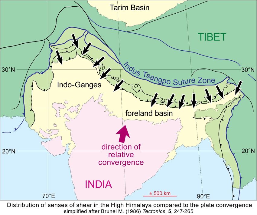
236

      Geological setting
The Himalaya contains the tallest mountain on the Earth, the 13 peaks that stand above 8000 m in
elevation, and most of the next, above 7500 m. This great elevation is attributed to the isostatic
response of a thickened, low-density crust with the Himalayas undergoing rapid uplift at rates
between 0.5 and 4 mm/yr. The mountain range is bounded at both extremities by strike-slip belts:
The Quetta-Chaman fault system in the west, in Pakistan and Afghanistan, and the Sittang zone in
Burma in the east.

The Himalaya and the Tibetan plateau are remarkable features of the geological history of Asia,
which, since the end of the Mesozoic Era, has been dominated by convergence with India, a small
block of continental lithosphere derived from Gondwana. Both oceanic magnetic anomalies and
paleomagnetism record well the relative motion.

From rifting to ocean spreading
Lithological, paleontological, geochemical, and geochronological evidence from basement rocks and
sedimentary cover indicates that India was part of Gondwana. Rifting along the northern Gondwana
margin began in the late Paleozoic. Left lateral, tensional wrenching separated the northern part
(Laurasia) and southern part (Gondwana) of Pangea and generated the Mesozoic Tethys Ocean from
Permian to Cretaceous times. In Middle/Late Jurassic and Early Cretaceous times, the Gondwana
supercontinent broke up into two landmasses: western Gondwana (Africa and South America) and
eastern Gondwana (Australia, Antarctica, India, and Madagascar). These two lands fragmented
further into their respective components during the Cretaceous. India separated from Antarctica and
Australia in the Early Cretaceous (ca 130-135 Ma) and from Madagascar in the LateCretaceous (85-
90 Ma).

jpb – Continent-Continent Collision in the Himalayas                             Tectonics-2020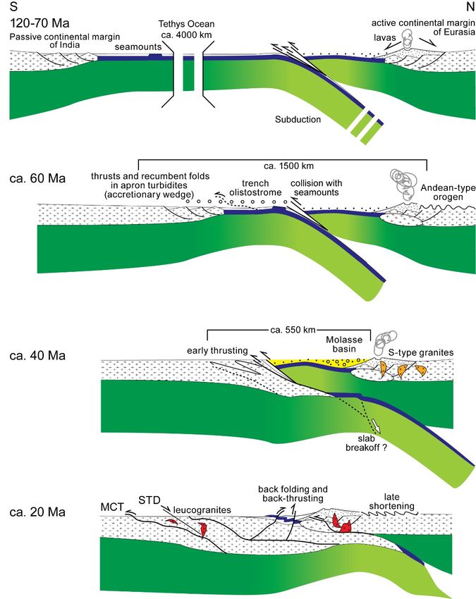
237

Chronology of the convergence
The northward drift of cratonic India relative to cratonic Asia started 100-90 Ma ago. Closure of the
Mesozoic Tethys Ocean resulted in the collision between India and Asia.

Marine magnetic anomalies of the Atlantic and Indian oceanic floors along with paleomagnetic
measurements in South Tibet and India offer an external time frame to the convergence history. Plate
tectonic reconstructions predict ca. 7500 and 8700 km at the longitudes of the western and eastern
ends of the Himalayas, respectively. This motion provides an indicative size of the consumed oceanic
Tethys and continental North-India lithospheres.
Paleomagnetic data from Southern Tibet compared with apparent polar wander paths for the Indian
plate show that intra-oceanic subduction and collision between India and Asia occurred at equatorial
latitudes, with progressive suturing from Paleocene in the north-western Himalaya (at 67-60 Ma)
until Early Eocene (ca. 50 Ma) in the eastern Himalaya. This indicates the anticlockwise rotation of
India during its northward drift.
        Up to Anomaly 22 (50 Ma), the displacement of India was very rapid, at a rate of 15-25 cm/yr.
In detail, India-Eurasia convergence began to slow down around 52 Ma.
        Between anomalies 22 and 21 (a time-space of 2-3 Ma), short-lived shifts in movement
direction are usually attributed to the onset of continental subduction and India-Eurasia collision.

jpb – Continent-Continent Collision in the Himalayas                               Tectonics-2020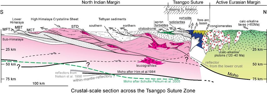
238

These rate and directional changes may reflect a fluctuating balance of pull vs buoyancy forces during
the subduction of the irregular northern continental margin of India.
        From Anomaly 22 to the 42 Ma Anomaly 18 the displacement rate decreased exponentially
to 4-5 cm/yr. and remained nearly steady until a smaller slow down around 20 Ma.
        The present-day rate of convergence across the Himalaya is about 1.5 cm/yr., a bit less than
half the total convergence rate.

The geodynamic interpretation of this 3-episode relative motion is generally as follows:
-      Subduction of the Tethys oceanic lithosphere, with an increasingly long slab pulling India,
thus enhancing fast movements.
-      Subduction of the Indian continental lithosphere after coming into contact with Eurasia;
deceleration of the relative convergence is attributed to the buoyancy of the continental lithosphere,
which increasingly resists subduction while the volume of the subducted continent increases.
-      Intracontinental shortening; the steady average convergence rate is controlled by
deformability of the colliding continental lithospheres and potential pull forces of subducting
continental India.

Age of collision
In the light of paleomagnetic information, the initial collision between the continental parts of the
Indian and Asian plates is placed in the Eocene, at 60-55 Ma, when the northward motion of India
slowed rapidly from >15 cm/ yr. to 4-5 cm/yr. This timing is consistent with that inferred from the
age of coesite-bearing eclogites (metamorphic pressure > 3 GPa at 55-45 Ma) in Ladakh. Other
arguments to date collision use the (1) youngest age of subduction-related granitoids (about 50Ma),
but there might be some time lag between cessation of subduction and intrusion, or (2) the age of the
youngest marine sediments along the suture zone (also about 50 Ma). The collision of India against
Eurasia was felt around the world. The abrupt 43 Ma bend in the Hawaii-Emperor seamount chain in
the Pacific records, a major plate reorganization and many of the volcanic arcs began to form at about

jpb – Continent-Continent Collision in the Himalayas                                Tectonics-2020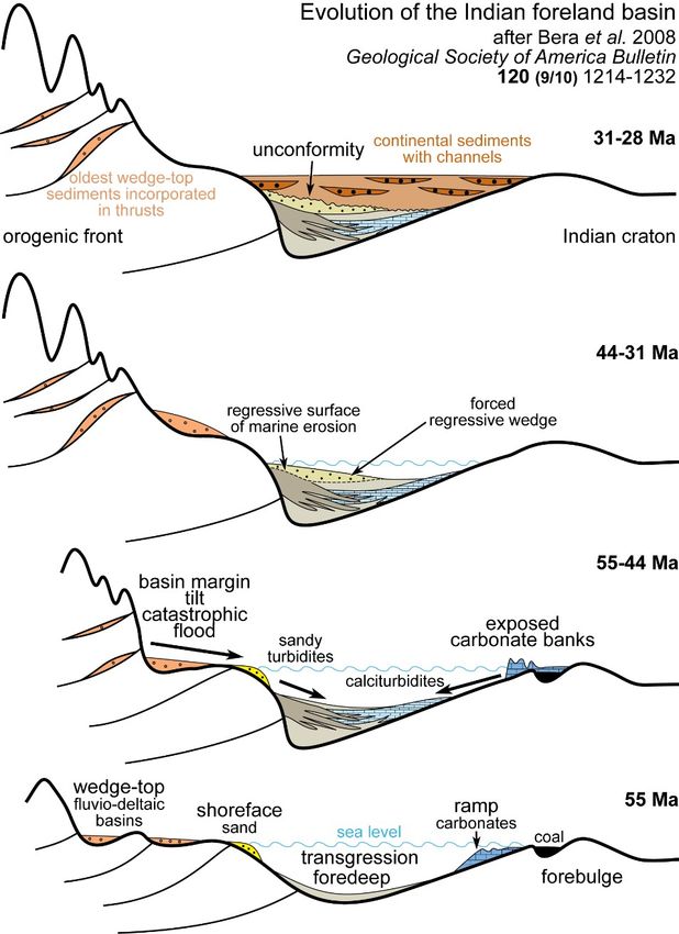
239

50 Ma (Tonga, Mariana, and Aleutian). In the north Atlantic, at about the same time, the ridge jumped
from the Labrador Sea to the Reykjanes Ridge east of Greenland. Yet a single age all along the suture
zone might be elusive.

      Long-lasting collision
Marine sediments deposited at around 55 Ma in South Tibet indicate that this northern part of India
was stable while northward drift was still at a velocity > 10 cm/yr. Slower drift at 45 Ma suggests
that initial collision had started.

A thin continental margin in front of cratonic India may have been subducted for several million
years without triggering any major tectonic or sedimentary signal until the end of the Eocene (ca 35
Ma). For example, marine sedimentation continues in the Persian Gulf well after the collision
between Arabia and Eurasia.

At ca. 35 Ma, the thicker, more buoyant Indian Craton increased compressional stresses, which
resulted in the shortening of both the Indian and Tibetan crusts and a possible second reduction in

jpb – Continent-Continent Collision in the Himalayas                               Tectonics-2020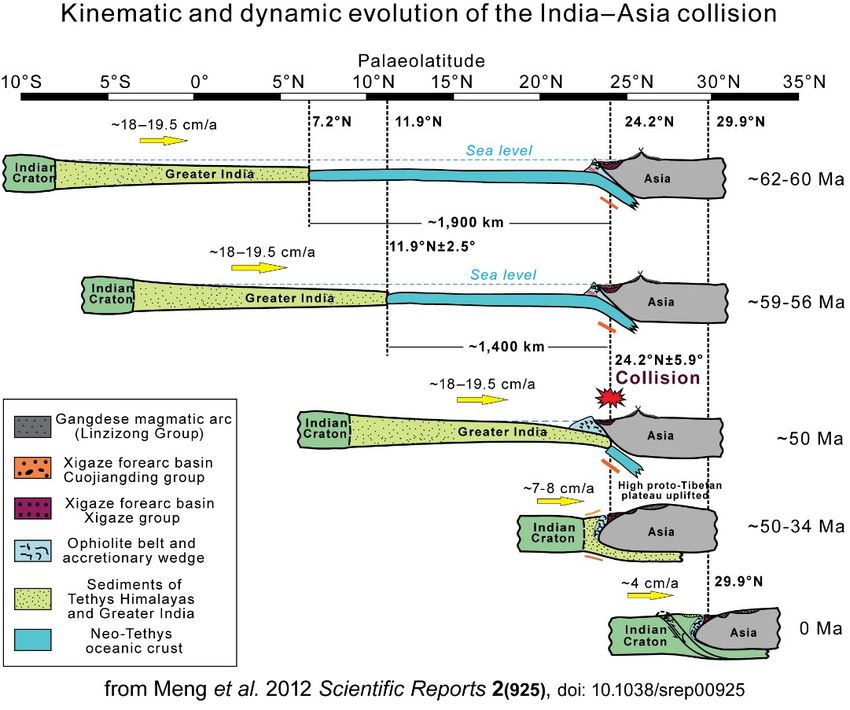
240

convergence rate at 20–10 Ma. This model involves a several hundred kilometers wide and thin
continental margin along North India.

Diachronous, eastward migrating collision
Continental faunas suggest that India and Asia were linked at 67 Ma in the West Himalayas.
Accordingly, some authors suggested that collision may have started earlier in the west and
subsequently propagated eastward all along the Himalaya, This is consistent with slightly faster
convergence rates on the eastern corner of India than on its western corner.

      Multiple collisions
Paleomagnetic and tomographic information suggests that sometime in the early Paleocene northern
India possibly collided with an intra-oceanic island arc at near-equatorial latitudes. This situation led
to a two-stage India-Asia collision at 60-55 and 25–20 Ma.

After the collision, India did not stop; it moved northward by over 1900 ± 850 km to Asia at an
average speed of 4-5 cm/yr.

Greater India
The pre-collision size of India is a critical question since it directly addresses how and where collision
began and how subsequent convergence between India and Asia has been accommodated.
Greater India names the pre-collision extent of India’s northern continental part. Its dimensions are
difficult to constrain because of large uncertainties on collisional deformation and corresponding
lithospheric “destruction”. Seismic data show that the South Tibet - Himalaya collision zone has an
approximately 65 km thick crust, while the crust of India, south of the Himalayas, is only 35-45 km

jpb – Continent-Continent Collision in the Himalayas                                   Tectonics-2020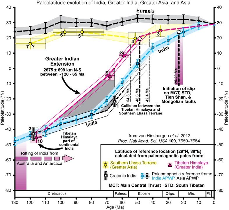
241

thick. A simple geometrical superposition explaining the nearly twice-thick crust of the Tibetan
plateau (Asian crust over India) suggests that Greater India may have been as wide as Tibet. Tectonic
reconstructions fitting the possible northern boundary of Greater India with the margins of Australia
in the Early Cretaceous (ca 130-135 Ma) imply an about 800 km wide Greater India. However, the
fast rate and a large amount of convergence since the 60-55 Ma collision require that Greater India
included a 1500 to 2500 km (from west to east) wide continental margin to the north of the Himalayas.
Paleomagnetic measurements on Tethys sediments infer >1300 km. Any of these figures is a hint for
a very wide, strongly extended (thinned) continental margin in front of India, until the collision.

Main tectonic and lithologic zones
Southwards-directed and propagating thrusting has assembled South Tibet and the Himalayas from
four main tectonic and lithologic units that are remarkably consistent all along the length of the
mountain belt. Major faults bound each of these units, which display distinctive stratigraphy and
metamorphic-magmatic history. From N to S, i.e. from the structural top to bottom, these units are:
- The Eurasian paleo-active margin, so-called Transhimalaya or Gangdese Batholith in South Tibet,
       which continues into the Karakoram Batholith in the western Himalayas.
- The Tsangpo Suture Zone that delineates the plate boundary along which the Tethys oceanic
       lithosphere that separated India and Eurasia was subducted beneath Tibet.
- The Tethys Himalaya exposing sediments deposited on the North Indian passive margin and its
       continental rise, which have been intruded by Eocene and younger granitoids of the North
       Himalaya domes.
- The Indian continent that comprises the High Himalaya and underlying thrust sheets of the Lower
       Himalaya over the Indian foreland.

jpb – Continent-Continent Collision in the Himalayas                               Tectonics-2020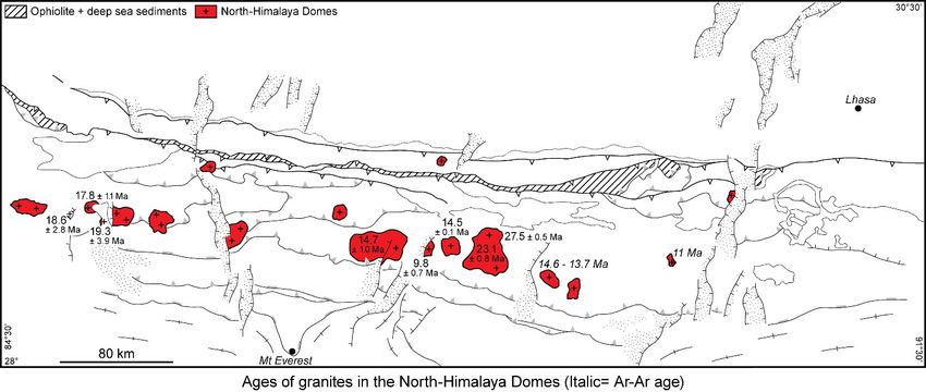
242

We first concentrate on a detailed section across the Tibetan side of the Himalayas to describe the
lithological and structural record of the geodynamic and orogenic evolution.

Eurasia active margin
The Lhasa Terrane, named after the capital of Tibet, formed the active continental margin of Eurasia
during the north-dipping Tethys subduction. The Lhasa Terrane comprises a continental part in the
north and a magmatic arc in the south.

          Lhasa Block
The continental Lhasa Terrane consists of a gneissic and granitic Precambrian basement covered with
Paleozoic to Upper Cretaceous shallow-water sediments. Mesozoic sediments contain Cathaysian
flora. Cathaysia was a microcontinent detached from Gondwana during the Late Paleozoic and drifted
across the Tethys until it collided with the Qiangtang terrane of southern Asia in the Late Jurassic.
This collision produced the Banggong-Nujiang suture, perhaps after south-dipping subduction below
the Lhasa Terrane. Cretaceous clastic sequences with plagioclase-rich volcano-clastic sandstones
were deposited in a basin that underwent a progressively increasing subsidence rate. This basin is
interpreted as a retro-arc foreland basin in front of a northward-propagating thrust system between
105 and 53 Ma. A major change in the depositional environment produced shallow water and
subaerial sediments associated with a Cretaceous-Paleocene (70-65 Ma) ignimbritic series that lies
unconformably on eroded folds of the Late Cretaceous and older rocks. The southern marine Early
Mesozoic basin may have deposited on an undated oceanic crust.

jpb – Continent-Continent Collision in the Himalayas                               Tectonics-2020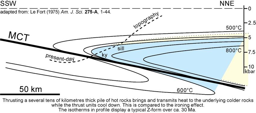
243

Magmatic arc: the Transhimalaya Magmatic Belt
           Magmatic rocks
The Transhimalaya is a long, linear mountain chain just north of and parallel to the Yalu Tsangpo
River (the Brahmaputra in India). The Transhimalaya (Chinese name: Gangdese) represents the
Cretaceous to early Tertiary Andean-type magmatic arc formed on the southern portion of the Lhasa
Terrane (then the active Asian margin), above the Tethys subduction. Magmatic structures define
imbricate plutons making up the calc-alkaline batholith with ages between 175 and 30 Ma. This
batholith includes two belts with distinct magma sources:
(1) The northern belt consists essentially of Cretaceous granitoids and peraluminous, S-type granites.
      Zircons with negative εHf(t), indicate the re-melting of an older crust. The sediments are
      Permian–Carboniferous to Late Jurassic–Early Cretaceous carbonates and volcaniclastic rocks.
(2) Late Cretaceous – Oligocene granitoids with mostly I-type (dominantly gabbroic to granodioritic)
      compositions dominate the southern belt. Zircons with positive εHf(t), indicate a juvenile
      source due to the partial melting of a basaltic oceanic crust with minor sediments (likely the
      Tethys slab). The sediments in this belt are mainly Jurassic–Cretaceous, overlain by volcanic
      rocks of an equivalent age (70-43 Ma) and chemistry. Volcanism apparently migrated
      southward with time.
The growing number of radiometric ages suggests that a period of relative quiescence separates two
major magmatic stages. The significance of this duality is still in discussion.
(1) The main stage is Late Cretaceous (ca. 113–80Ma), ending with adakitic intrusions.
(2) The second episode is early Paleogene (ca. 65–46Ma) with a culmination around 50 Ma. The ca.
      50 Ma magmatic crisis is speculated to represent slab break-off.
Geochemistry indicates that post ca. 35 Ma rocks include ultra-potassic, adakitic, and shoshonitic
volcanism and NS trending dikes (ca. 23-8 Ma). In the light of temporal relationships, these rocks
are related to post-collision, E-W extension. Geochemistry suggests also that these late magmas

jpb – Continent-Continent Collision in the Himalayas                                Tectonics-2020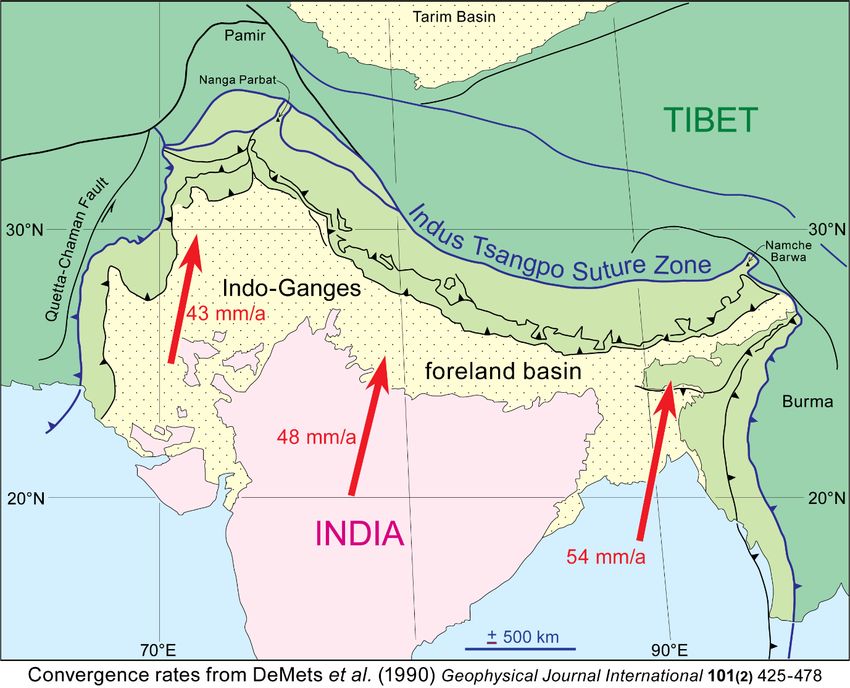
244

mixed mantle-derived and felsic lower crust-derived melts, perhaps the molten Indian crust subducted
below the Lhasa Terrane in Miocene times.
           Metamorphism
Metamorphism of the rocks intruded by the Transhimalaya plutons is heterogeneously distributed.
The regional grade is usually very low grade to greenschist facies. High-temperature - low-pressure
granulite facies assemblages (andalusite - cordierite - garnet - spinel) occur at the contact between
metapelites and intrusive gabbros.
           Structures
Polyphase deformation dominates the southern part of the Lhasa Terrane. In particular:
-       Isoclinal F1 folds have a weak and axial planar S1 foliation bearing a north-south stretching
lineation. The intensity of the F1 fabric and metamorphism increases towards the Yalu Tsangpo
suture. This deformation gradient is ascribed to north-dipping subduction of the Tethys oceanic
lithosphere while calc-alkaline magmatism of the Transhimalaya Belt took place possibly along a
continent-ocean margin, leaving remnants of continental Precambrian crust to the north and of
(Triassic?) oceanic crust to the south. This event affected Lower Cretaceous sediments.
-       F2 upright folding with fanlike S2 cleavage is pervasive and locally more pronounced than
the F1 fabric. F2 structures represent a period of continuing shortening, part of which between
Transhimalaya intrusions. This folding/intrusion association is compared to an Andean-type orogen
that included a retro arc thrust belt and foreland basin before the continental collision.

       - Emersion and erosion by latest Cretaceous times truncated F1 and F2 structures. The
unconformable Paleocene has undergone minor shortening (ca. 10%) with low amplitude and several
kilometers wavelength undulations. Low-angle reverse faults with less than a few kilometers
displacement cut in place 10 Ma-old lava. This indicates that significant crustal shortening (nearly
50%) was completed here by Palaeocene times, before the collision with India.
           Geological history
Paleoelevation reconstruction using oxygen isotopes from several sedimentary formations suggests
that the magmatic arc had reached ca 4500 m elevation in Paleocene-Early Eocene times. Altogether,
the tectonic and paleotopography history suggests that the continental margin of Asia underwent
crustal thickening, elevation gain, and erosion before the India-Asia collision. Arc magmatism
stopped in Eocene times, presumably reflecting the time of the collision and the cessation of the
subduction of oceanic lithosphere.

jpb – Continent-Continent Collision in the Himalayas                               Tectonics-2020
245
Great backthrust
Conglomerates intercalated with red shales, sandstones, and local basaltic and ignimbritic flows lay
unconformable on the southern Transhimalaya Magmatic Belt. Southward draining delta, braided-
river, and alluvial fan systems deposited the narrow and discontinuous occurrences of Late Oligocene
- Early Miocene (ca. 26 – ca. 15 Ma) sequence. Northwards and westward draining systems
developed from 19 to 15 Ma. Eastward flowing rivers established at ca 15 Ma laid conglomerates
perhaps as late as the Early Pliocene (ca. 5 Ma). The modern Tsangpo River is perhaps inherited from
that system. These deposits are similar to the Indus Molasse in Ladakh and the Kailas regions. Suture-
parallel, north-verging folds with a weak, steep dipping cleavage are related to the near-vertical to
south-dipping fault traced along the southern margin of the Lhasa Block. Striations on the fault plane
and related fractures indicate dextral strike-slip faulting before northwards backthrusting in Mid-
Miocene times. This major fault zone has overprinted the presumably south-verging, primary features
of the suture where Indian units are in direct contact with the Transhimalaya lithologies.
Tsangpo Suture: The oceanic domain
The narrow (generally < 15 km) Yalu-Tsangpo Suture separating the Indian and Eurasian Plates in
South Tibet is traditionally traced along the ophiolite sheets. Three rock subunits represent the
hanging-wall plate of the suture. They are, from north to south 1) forearc turbidites (the so-called
Xigaze series, after the second city of Tibet) 2) ophiolites, and 3) deep-sea sediments.
Forearc turbidites
The northern section of the Xigaze series is composed of a virtually unmetamorphosed and volcano-
plutonic turbidite sequence deposited from early Cretaceous to Maastrichtian times (115-65 Ma).
Interlayered limestones are paleontologically dated Late-Albian. Late Cretaceous conglomerates with
pebbles from the Transhimalaya plutonic and volcanic rocks attest for topographic growth and deep
erosion of the already thickened crust of the Andean-style margin on the Lhasa Terrane. Shallow
marine, Paleocene to lower Eocene limestone, volcano-clastic sediments and volcanic tuffs
stratigraphically cover the Cretaceous turbidites. Marine sedimentation ceased at about 50 Ma, giving
way to continental, molasse type deposits in a narrow, Oligocene to Miocene depression. Detrital
chromium-rich spinel of ophiolite affinity (TiO2 generally < 0.1 wt%) appeared during the Paleocene
(65 to ~55 Ma).
jpb – Continent-Continent Collision in the Himalayas Tectonics-2020246
The Xigaze sediments represent an upward-shoaling forearc basin lying on the plutonic belt to the
north and the ophiolites to the south. Sedimentation started with the Early Cretaceous (ca. 130- 115
Ma) deep-water tuffaceous chert and siliceous mudrocks with Albian-Cenomanian radiolarites
forming the sedimentary cover of pillow basalts of the adjacent ophiolite and continued as slope,
shelf, and eventually deltaic and fluvial deposits from the Late Cretaceous onward (post ca. 75 Ma).
These several-kilometer-thick series appear within a large east-west trending synclinorium shortened
by 40-65% after the Early Cenozoic with dominantly south-verging, tight-to-open folds, a steep
dipping cleavage, and no metamorphism. This relatively simple structure may result from the high
strength of the underlying ophiolite. Additional, undefined amounts of shortening were involved in
thrusting below and backthrusting over the Lhasa Terrane.
The basin is squeezed between backthrusts along both its northern and southern boundaries. Local
structures are associated with Post-Oligocene-Miocene backthrusting on both sides of the
synclinorium. In Ladakh, similar associations of the same age occur in the Dras formation where
calc-alkaline lavas overlie oceanic basalts.
Ophiolites
Thin sheets of ophiolite and deep water sediments (radiolarites) occur discontinuously for nearly
2500 km along the Tsangpo suture. They have preserved a bulk normal polarity. Where they are
absent, only backthrusts and strike-slip faults (locally marked by alignments of geysers) are seen.
Two ophiolitic successions of different ages, petrography, and geochemical affinity are described.
The older represents an island arc succession, the younger represents the supra-subduction oceanic
floor. These ophiolites have been thrust southward for as much as 80 km from the suture over the
Tethys sediments. Remnant klippen partly represent Cretaceous (ca 125 Ma) seamounts that existed
in the Tethys Ocean. The related volcanism may be evidence for the thermal erosion of the supra-
subduction oceanic lithosphere.
jpb – Continent-Continent Collision in the Himalayas Tectonics-2020247
Island arc
Island arc igneous and volcaniclastic rocks (boninitic pillows, basaltic-andesitic breccias and dikes,
dacites, rhyolites, diorites, and leucogranites) are dated between ca 160 and ca 150 Ma. They form a
dismembered and overturned sequence imbricated with the forearc and the tholeiitic ophiolites. The
island-arc (called Zedong Terrane) was active in Mid-Jurassic to Early Cretaceous times.
Tholeiitic ophiolites
The tholeiitic ophiolites have ages from ca. 130 to ca. 120 Ma, consistent with radiolarian
biostratigraphic data from the sedimentary cover of pillow basalts. They represent a tectonically
disrupted oceanic lithosphere. The ultramafic rocks were generated from a MORB-source upper
mantle. They are mostly chromite-bearing harzburgites and lherzolites; dunites are scarce.
Petrology and geochemistry indicate forearc spreading ridge origin and subsequent (boninitic)
alteration in the supra-subduction mantle wedge. The associated mafic rocks (lavas, dolerite dikes,
and cumulate gabbros) also recorded this two-stage evolution. These arguments support the
interpretation that these ophiolites formed in the forearc of the Transhimalaya magmatic arc. Forearc
spreading may sign slab rollback.
Metamorphic sole and ophiolitic mélange
A discontinuous serpentinite “mélange” at the base of the ophiolite thrust sheets contains garnet-
amphibolites (peak metamorphic conditions: 1.3-1.5 GPa, 750 - > 900°C) interpreted as elements of
a dismembered intra-oceanic thrust sole. Zircon U–Pb results date the protoliths at 124–125 Ma. Ar-
Ar ages on amphiboles span 70-130 Ma. The 120-130 Ma cooling ages are slightly younger or overlap
magmatic and sedimentary ages obtained from the overlying ophiolite. This age coincidence and the
high metamorphic temperatures support a model in which the subducted oceanic crust was nascent
while the thrusting lithospheric mantle was still hot. In short, the subduction zone started near the
spreading axis that formed the ophiolites.
More generally, low-temperature mylonites and serpentinites floor the ophiolites. Below, an
ophiolitic mélange characterized by blocks of sandstone, chert, siliceous shale, limestone, basalt,
mafic schist, and ultramafic rocks is interpreted to be fragments of accretionary prism and trench
rocks, within a strongly deformed matrix of serpentinite, sandstone, and siliceous shale. Ar-Ar
jpb – Continent-Continent Collision in the Himalayas Tectonics-2020248
cooling ages of amphiboles from mafic schist yielded 65-60 Ma ages. Stretching lineations are north-
south. Small-scale south verging folds and asymmetric boudinage structures indicate a top-to-south
sense-of shear.
Deep-sea sediments
Late Triassic to Senonian radiolarites, turbidites, and locally basalt, form an imbricate thrust-stack.
South-facing folds deform the early, north-south stretching lineation associated with sheath folds.
These structures indicate transport from north to south during greenschist facies metamorphism.
These deep-sea sediments would represent material off-scraped from the down-going slab and
accreted into the subduction complex during the Late Early Cretaceous.
Indian passive margin
Three major structural and lithological zones represent different proximal-to-distal parts of the
ancient passive margin of northern India. From north to south they are:
- The Tethys Himalaya.
- The High Himalaya.
- The Lower Himalaya and Indian continent.
Tethys Himalaya
Generally non- to low-metamorphic grade sediments, now situated directly south of the Tsangpo
Suture, represent the former leading edge of India. Several units are identified.
Apron turbidites
The ophiolites and the radiolarites are thrust onto an allochthonous turbidite sequence with late
Triassic to Liassic or Cretaceous (?) marine fossils.
Large-scale recumbent, subisoclinal F1 folds have inverted in many places the stratigraphy. South-
west verging mesoscopic and non-cylindrical F1 folds trend N030-180 and contain an S1 slaty
cleavage formed in low-grade conditions of metamorphism. Quartz fibers and long axes of pressure
fringes are parallel to the N340-030 stretching lineation equated with the transport direction. Meters
thick crush zones formed under non or very low-grade conditions of metamorphism delineate the
basal thrusts of these turbidites, the ophiolites, and their metamorphic sole. They cut the F1 structures.
jpb – Continent-Continent Collision in the Himalayas Tectonics-2020249
Both the thrust contacts and the F1 folds are folded about F2 structures in various ways, as upright
chevron folds (interlimb angles 110-50o) may coexist with subisoclinal folds with rounded hinges
and overturned to the south. The F2 axes are parallel to a N060-120 crenulation lineation. F2 folding
increases in intensity northwards. Local N040-130 kinks with different axial plane attitudes represent
an F3 event and may be contemporaneous with post-F2 movement along basal thrusts.
The Late Triassic to Late Mesozoic turbidites are attributed to the continental margin apron of India,
intensely deformed during Early Paleocene southward shearing and transport. The study of detrital
zircons suggests that some Upper Triassic sequences are derived from the Lhasa Terrane thus may
represent the northern margin of the Tethys Ocean rather than India.
Olistostrome
An olistostrome with a black, shaly matrix is partly transgressive on the recumbent fabrics of the
apron turbidites. Oldest exotic blocks are Late Permian limestones derived from the Indian
continental margin or oceanic plateaux. The youngest blocks, folded before redeposition, are
Maastrichtian to lowermost Paleocene Globotruncana limestones. The youngest fossils found in the
matrix are Late Paleocene, which is taken as the age of the olistostrome. The various lithologies seen
in the blocks attest for distinct paleogeographic environments such as the distal Indian continental
margin, pelagic horsts, and oceanic seamounts (equivalent to the Oman exotics?).
This formation is folded, along with the turbidites, about the east-west trending, upright to south-
facing folds, with a non-metamorphic fanning cleavage parallel to the bulk axial plane. The folding
is correlated with the F2 event with crenulation cleavage in the apron turbidite nappes.
Tethys Himalaya
The fossiliferous Cambrian to Eocene sedimentary sequence that formed a continental shelf
environment on the Indian continental margin (clastic strata, carbonates, and shales) passed
northwards into a deeper water facies (distal shelf and slope pelites and turbidites). Southward
propagating, imbricate thrusting, and folding commenced as the Indian continent subducted
northward under the Eurasian plate. A major thrust separates the northern and southern Tethys
sequences thus defining two subunits.
North Tethys sediments
The north Tethys sediments show downward increasing metamorphism from regional low grade to
localized staurolite kyanite schist. In the structural section, the lowest rocks are Lower Ordovician
orthogneiss underlying metamorphosed rocks and recrystallized Permian limestones. Overlying the
Permian, the Mesozoic includes a thick and monotonous calcareous turbiditic sequence of up to
Maastrichtian age involved in polyphase deformation. The Late Cretaceous pelagic environment
seems to have disappeared from east to west. Undated basic dikes and sills suggest continental rifting.
The first major structural event generated large-scale recumbent folds overturned to the south-west
and a well-developed slaty cleavage with an N350-040 stretching lineation. The bulk strain increases
northwards towards the Yalu Tsangpo Suture and upwards under the ophiolitic and associated
nappes. The Late Palaeocene olistostrome is unconformably lying on these structures.
The structurally deeper metamorphic rocks show a comparable polyphase deformation with a
downward increase in the intensity of the fabric contemporaneous with the intermediate pressure
metamorphism. The problem arises from the radiometric ages of micas as young as ca 10 Ma (Ar/Ar
method) and hence inconsistent with the Maastrichtian-Palaeocene age of the recumbent folds
previously described. Both the deformation and the metamorphism of the lower rocks may be
associated with a ductile thrust zone whose deformation front does not reach the upper part of the
pile but instead produces the thrust and locally a trailing imbricate fan to the south between the
northern and southern Tethyan sediments. The juxtaposition of two areas having comparable fabrics,
though different ages, is one of the striking features of the northern subunit. This is a consequence
of the heterogeneity of the shear deformation during thrusting, which affects areas close to the thrust
plane and preserves the sequence away from the thrust.
jpb – Continent-Continent Collision in the Himalayas Tectonics-2020250
North Himalaya Domes
A long antiform occurs, about 50km south of and parallel to the suture. A string of domes of
Proterozoic (ca 1800 Ma) basement gneiss with small volumes of 46-30 Ma granitoids and late
Miocene (19-7 Ma) two-mica granites (collectively called North Himalayan Belt) stretches along this
antiform. Gneiss and granitoids provide evidence for increasing metamorphic pressure and
temperature (up to 0.7-0.8 GPa for ca 650°C) at 45-35 Ma and protracted melting of the Indian-
derived middle crust until the intrusion of the late Miocene two-mica granites. The domes exposing
mid-crustal rocks deformed, metamorphosed, and melted during the Himalayan orogeny are
attributed to thrusting, subsequent extension or diapirism, or a combination of all of these
mechanisms.
South Tethys sediments
The southern Tethys sediments range in age from Cambrian to mid-Eocene without any significant
unconformity. They are identical to the10-km thick platform-type series known further west in
Ladakh. The sediments consist of mixed clastics and carbonates up to early Permian and mainly shelf
carbonate in the late Permian to early Eocene. They represent nearly continuous deposition of
shallow-water, marine strata over the stable Indian shelf. In more detail, it is a composite of two
superposed rift-to-passive margin sequences: the early Paleozoic to Carboniferous one that
accumulated in the Paleotethys Ocean until the breakup of Pangea, and the Permian to the Cretaceous
southern passive margin of the Tethys Ocean.
In contrast to the deeper water North Tethys sediments, the South Tethys sediments are non-
metamorphosed and have suffered one main phase of east-west trending box and chevron folds that
can be followed for tens of kilometers along their axial traces. The intensity of shortening decreases
southward up to the faulted contact between the southern Tethys sediments and the metamorphosed
schists and gneiss of the High Himalaya.
jpb – Continent-Continent Collision in the Himalayas Tectonics-2020251
Note that there was no pre-alpine tectonic episode and that youngest marine sediments are Priabonian
(38-34 Ma) ca. 10 Ma younger than collision, if it is Early Eocene.
Indian Continent
Convergence between India and Eurasia continued after their initial contact, up to the present (about
5 cm/yr.). Several hundred kilometers of shortening, and possibly as much as 1500 km took place
between the Tethys Himalaya and the Indian craton since the Paleocene. Large-scale thrust
imbrication with the propagation of shortening towards the foreland absorbed a major part of this
intracontinental shortening. The resulting Himalaya is the fold-and-thrust wedge formed within the
Indian continent. It consists of three thrust-bounded units that extend all along the belt, from top to
bottom:
- The High Himalaya is a southward-extruded wedge of high-grade metamorphic gneiss
intruded by variably deformed Miocene leucogranites. It is bounded by a normal fault on
the top and the largest Himalayan thrust within the Indian plate at the bottom (the Main
Central Thrust = MCT). The MCT accommodated up to 250 km of thrust movement.
- The Lower Himalaya is mostly composed of Precambrian to Mesozoic low-grade
metasediments. Its bottom is another important, north-dipping intraplate thrust, which is
still active: the Main Boundary Thrust (MBT).
- The Indian Foreland (called Sub-Himalaya) and the adjacent Gangetic foredeep.
Seismic studies and the rate of southward advance of the foreland basin indicate that the Himalayas
currently absorb10 to 25 mm/yr. of shortening. The Himalayan topographic front, i.e., the zone where
the average elevations relatively abruptly change from about 2 km to about 5 km, defines a small
circle on a sphere and closely coincides with the MCT. This coincidence suggests a genetic
relationship between the bending and underthrusting of the Indian subcontinent beneath the
Himalayan blocks and the formation of the High Himalaya just north of the MCT.
High Himalaya
The Himalaya consists of a north-dipping pile of tectonostratigraphic units that isotopic data qualify
as late Proterozoic to early Paleozoic gneiss, migmatites, and schists of the upper continental crust of
India. Tethyan Mesozoic sediments, originally situated on the northern margin of India, lay locally
on the gneiss and schists.
jpb – Continent-Continent Collision in the Himalayas Tectonics-2020252
Orogen-parallel normal fault
The contact juxtaposing the hanging wall sediments of the Tethys Himalaya on schists, gneiss, and
Miocene leucogranites of the High Himalayas is a north-dipping normal fault: the South Tibetan
Detachment (STD). It is responsible for northward shearing of the leucogranites and superposition
of unmetamorphosed sediments onto staurolite-garnet schists. To the east, steeply dipping, brittle
normal faults separate Jurassic schists from gneisses indicating several kilometers down-to-the-north
vertical movement. Ductile normal faulting, dated from 24 to 11 Ma, perhaps lasted to the Pliocene.
Normal faulting is contemporaneous, for at least part of its history, with structurally lower, southward
thrusting on the MCT.
Gneiss and inverted metamorphism
Rocks of the Indian continental shield and its Pre-Paleozoic sedimentary cover underwent high-grade
regional metamorphism and intrusion by leucogranites during the Cenozoic formation of the
mountain range. The gneiss and migmatites bear evidence of multiple deformation and
recrystallization events ascribed to the Himalayan southward shearing, with the dominant fabric
defined by amphibolite facies assemblages. The stretching and mineral lineations are roughly normal
to the trace of the MCT all along the belt and parallel everywhere the shear direction defined by
ubiquitous kinematic indicators. This fabric indicates the transport direction of the thrust sheet.
However, the range-scale radial pattern implies that the local motion does not correspond to the
average plate convergence.
jpb – Continent-Continent Collision in the Himalayas Tectonics-2020253
The 2 to 10 km thick thrust sheet is a deeply rooted crustal slice whose bottom consists of biotite-
garnet-kyanite micaschists and the middle and upper parts of sillimanite-kyanite, K-Feldspar
assemblages and sillimanite-cordierite-garnet metapelites.
The polyphase, metamorphic history implies three stages:
1) The oldest metamorphic record is inferred from Lu/Hf garnet ages (ca 55 Ma) and ca 45 Ma U-Pb
ages measured on zircons. Ages of zircons in strongly altered eclogites (670°C->1.5 GPa)
found towards the top of the gneiss pile are 23-14 Ma, which is at odds with the 45-35 Ma
(perhaps younging eastward) monazite and zircon ages of the surrounding gneiss recrystallized
under Barrovian-type metamorphic conditions (550-680°C - 0.8-1.4 GPa). This metamorphic
stage took place during the burial of the Indian crust following the continental collision.
2) Early exhumation occurred at a higher temperature (650-800°C) and lower pressure (0.4-0.7 GPa)
during the Miocene (30-18 Ma). This is the dominant metamorphic event, which obliterated
most of the evidence for the earlier, higher-pressure event.
3) Further exhumation occurred later in the Miocene (20-15 Ma U-Pb ages of sillimanite grade rocks)
at a lower temperature (500-700°C) and pressure (0.2-0.4 GPa).
The Barrovian metamorphic structure is important on a conceptual point of view. The gneiss pile
above the MCT records metamorphic temperatures from ca. 550°C near the MCT up to 700°C in the
jpb – Continent-Continent Collision in the Himalayas Tectonics-2020254
overlying migmatites. Corresponding pressures decrease upward. Conversely, the metamorphic
sequence is inverted in the footwall rocks, with a continuous decrease in metamorphic grade and
temperature downward: The sillimanite-bearing migmatites and gneiss occur above a narrow zone of
kyanite-bearing schists, in turn above successive staurolite, garnet, biotite, and lower grade
metamorphic zones.
Three classes of models explain such inverted metamorphic zones:
- Post-metamorphic isograd inversion: Late thrusts or recumbent folds deformed pre-existing
isograds and produced the apparent thermal inversion.
- Syn-metamorphic isograd inversion: Large scale, foreland-directed thrusting brought a hot
metamorphic pile (rocks that were once > 650°C) overriding and metamorphosing underlying
sediments that never reached such temperatures.
- Syn-metamorphic inversion of isotherms: Viscous heating associated with the MCT produced
an inverted thermal structure.
The last two processes suggest that downward conductive heating of the underlying Lower Himalaya
from the High Himalaya gneiss is coupled with the cooling of the High Himalaya hanging wall. In
that case, inverted geotherms developed during slip on the MCT (the ironing effect). Dating of the
metamorphic history, which follows a classical, clockwise Pressure-Temperature-time loop, indicates
that thrusting exhumed the sequence rapidly enough to preserve the inverted metamorphic gradient.
Synmetamorphic shearing evolved at 20-25 Ma. Burial of the footwall rocks ceased at ca. 10 Ma but
further reactivation lasted into the Late-Miocene (5-8 Ma).
Leucogranites
Melting of the continental crust generated the 25 to 12 Ma tourmaline-muscovite-garnet
leucogranites. These leucogranites define a belt of small plutons, stokes, and dike networks in the
upper levels of the High Himalaya. Their shear fabrics give evidence for the normal faulting on top
of the High Himalaya. Residual and/or peritectic andalusite along with sillimanite and biotite
inclusions in cordierite indicate that melts formed by dehydration melting of biotite at T = 660-700
°C under low-pressure conditions (P < about 0.4 GPa). Mineral ages between 18 Ma and 15 Ma
indicate exhumation at a rate of 0.7 to 0.8 mm/yr.
Main Central Thrust
The amphibolite facies High Himalaya gneisses have been thrust over lower grade (greenschist)
metasedimentary, metavolcanic, and metagranitoid rocks, including Miocene metasediments, along
the MCT. The MCT is a north-dipping ductile zone that was intermittently active between 22 and 5
Ma accumulating a minimum 140 km throw, and perhaps as much as 300-600 km. Despite large
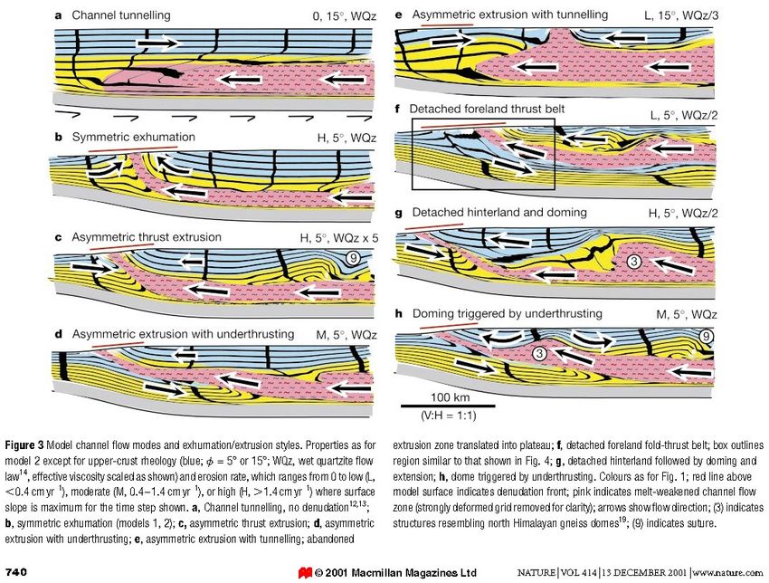
jpb – Continent-Continent Collision in the Himalayas Tectonics-2020255 uncertainty, intra-plate, continental subduction of southern India along this contact characterizes the Himalayan orogeny proper. Exhumation problem The concomitance between the STD and the MCT involves the southward movement of the gneiss in between. Several kinematic and mechanical models have attempted to explain this orogenic process. Gravity-driven extrusion Initial models involved wedge-shaped High Himalaya gneiss sequences with the STD and the MCT merging at depth. Two interpretations pictured the forward extrusion of this gneiss wedge. - Analog modeling of continental subduction suggests gravity-driven, upward extrusion of a continental wedge subducted to depths where its buoyancy overcomes the crustal strength. The wedge moves upward and forelandward along a new, crustal-scale thrust (MCT) while its upper boundary records a normal sense of movement (STD). jpb – Continent-Continent Collision in the Himalayas Tectonics-2020
256

- Mechanical modeling attributes extrusion to gravitational collapse in response to the extreme
topographic gradient along the southern margin of the Himalayas in Miocene times. This extension
would affect the upper crust only.

Mid-crustal channel flow
Some mechanical models propose a laterally continuous, low viscosity, mid-crustal “layer” of
partially molten gneiss flowing southwards from beneath the Tibetan Plateau between sub-parallel
STD and MCT and eventually extruding towards the Himalayan range front. In these “channel flow”
models, the horizontal gradient in lithostatic pressure between the Tibetan Plateau and the Himalayan
front provides the driving force. Efficient and focused erosion (i.e. denudation) on the southern slopes
of the Himalayas, along the high relief between the plateau and the orogenic front, initiates
exhumation of the gneiss from mid-crustal depths to the surface.

Lower Himalaya
The Lower (or Lesser) Himalaya is bounded to the north by the MCT and to the south by the MBT
(Main Boundary Thrust), which initiated in late Miocene time, when the thrust belt front propagated
southward into the foreland region. The MBT is still active and focal mechanism solutions define a
simple planar zone from about 10 km and 20 km depth with an apparent dip of 15°N.
The Lower Himalaya is a low-grade assemblage of a 20 km thick, imbricate thrust pile of mid-
Proterozoic to Cenozoic sequences originally deposited on the Indian continental crust. Cambrian
stromatolitic dolomites record the epicontinental marine transgression on 1.5 - 2.2 Ga old gneisses.
and 500 Ma old granitoids that have been deformed into orthogneiss. Metasediments are lower grade
yet similar lithologies as those of the High Himalaya but with no Cenozoic igneous activity. Much
of the Phanerozoic shelf sequence (shales, sandstones, and limestones) is of Gondwana type but does

jpb – Continent-Continent Collision in the Himalayas                                  Tectonics-2020
257

not correlate with the sediments of the Tethys Himalaya. Thermochronologic studies suggest that
before 13 Ma most of the Lower Himalaya rocks were located either beneath a paleo-foreland basin
or beneath MCT-related nappes. Late Oligocene to Early Miocene fluvial formations registered the
emergence of the Himalaya Mountains. Most of the Himalayan thrusting system in the Lower
Himalaya developed during the last 15-10 Ma.

Indian Foreland
The tectonic loading of the northern edge of the Indian subcontinent during the growth of the
Himalaya created the large Indo-Gangetic flexural basin, which extends along the entire southern
side of the mountain range. The ~10-km-thick, mostly non-marine, fluvial, clastic sediments of this
basin have preserved the denudation records of intimate interplay between tectonics and erosion of
the India-Asia collision and the subsequent development of the Himalayas.
The development of the foreland basin begins with the initiation of the continent-continent collision
at 55 Ma. The oldest strata are transgressive marine Latest Paleocene–middle Eocene sandstones
(5741.5 Ma). They predominantly recycled an ophiolitic and a volcanic sedimentary source and
contain ca. 50 Ma detrital zircons. Diachronous arrival of ophiolitic to low-grade metamorphic
detritus in the foreland sediments from Pakistan to Bangladesh is consistent with progressively
younger closure of Tethys, from the latest Paleocene in the west to Eocene or even later in the east.

jpb – Continent-Continent Collision in the Himalayas                               Tectonics-2020
258

In Oligocene-Miocene times alimentation from suture rocks drastically reduced while the
metamorphic grade of detrital grains increased from very low to low grade. In the latest Oligocene,
the embryonic thrust belt partially separated the suture zone from the Himalayan foreland basin.
Himalaya-derived detritus appear sometime between 35 and 40 Ma in the east like in the west of the
basin. The occurrence of metamorphic grains coincides with the timing of displacement along the
Main Central Thrust. As convergence and the subsequent tectonic activity went on, the resultant
flexural depression migrated progressively southwards and was filled by a 5 to 8 km thick continental
and terrigenous sequence derived from the rising/being eroded Himalayas and dated mostly from the
Miocene.
These synorogenic molasse conglomerates siltstones and shales (often termed Siwalik or Sub-
Himalaya sediments) were laid down in giant, interfingering alluvial fans that lap onto the Indian
Shield. In detail, the discontinuous series comprises most of the Cenozoic but there was a general
lack of sedimentation during the Late Eocene and almost the entire Oligocene. This 15-20 Ma-long
sedimentary gap may reflect an important change in orogenic processes. One interpretation involves
the passage of the flexural forebulge migrating southward through India.
Deformation varies in space and time from tightly folded and faulted sequences to almost
undeformed. Most folds and thrusts are sub-parallel to the topographic front of the Himalaya, which
coincides with the MFT (Main Frontal Thrust). The bulk shortening intensity decreases southward,
away from the MFT, the youngest and active thrust that places the molasse atop sediments of the
Indo-Gangetic flexural basin. This basin is the present-day foredeep established upon the basement
of Peninsular India. Acceleration in the molasse-sedimentation rate indicates that the MBT was first
active at about 11 Ma. This is the same age as in the western Himalaya (see lecture on Kohistan),
which suggests that initiation of the MBT was nearly synchronous along the entire length of the
Himalaya. This interpretation is supported by the onset of erosion of the Lower Himalaya at 10-8Ma,
after uplift induced by thrust tectonics on the MBT. The MFT became active in Pliocene time and
truncates Quaternary conglomerates.

Geophysical structures
Knowledge of the deep structures is essential to understand why the High Himalaya and the suture
zone have attained their impressive height.

      Focal mechanisms
The Himalayas are seismically very active. During the past century, four earthquakes of magnitude
> 8 have occurred in the mountain range, with a large number of small and medium-sized events.
The best-located epicenters define a relatively simple, planar zone having an apparent northward dip
of about 15°. Focal mechanisms indicate that it is a master thrust separating the footwall Indian
continental crust from the overriding Himalayan gneiss sheet. The gently dipping fault planes exhibit
slip in a sub-horizontal direction, normal to the Himalayan arc.

jpb – Continent-Continent Collision in the Himalayas                               Tectonics-2020
259
The presence of seismicity at 80-110 km depths in southern Tibet indicates that the upper mantle is
cold enough to experience brittle deformation.
Seismic reflection
Geophysical imaging has extended surface geological studies to depth.
Crustal structures
Seismic reflection profiling shows a 12° north-dipping band of reflections corresponding to the
crustal thrust (décollement) beneath which the Indian lithosphere is underthrusting the Himalaya. The
MFT, MBT, and MCT are depicted as splay faults merging into a260
Older reflection and wide-angle reflection data suggested a decoupling zone within the crust, the
upper crust sliding, and/or folding independently of the lower crust. The major thrust units (MCT,
MBT, and the North Tethys sediments) correspond to prism-shaped seismic structures superposed
along imbricate, north-dipping thrusts in the upper crust. Conversely, thrusts in the lower crust dip to
the south and may involve upper mantle rocks. Decoupling and thrusting the lower and upper crustal
layers allow crustal shortening and thickening of the North Indian Margin in a complex duplex of
gently dipping ductile shear zones with opposite vergence. The base of the duplex would lie near the
base of the crust or within the sub-crustal lithosphere.
Moho
India has a typical shield S-wave velocity structure with a thick, high-velocity lithosphere overlying
the asthenosphere. The Moho is nearly horizontal at about 45 km depth beneath the Indian Shield. It
deepens over a distance of 120 km beneath the Himalaya to reach about 75 km depth in southern
Tibet.
jpb – Continent-Continent Collision in the Himalayas Tectonics-2020261
This supports the underthrusting of the Indian plate to be responsible for the double thickness of the
crust of South Tibet and somewhat contradicts earlier interpretations of a stepped Moho in an
imbricate crust.
Lithosphere
Deep seismic reflections indicate that the Indian continental lithosphere has underthrusted Tibet as
far as half the plateau width, namely to the Bangong-Nujiang suture. This is inferred from a high P-
wave velocity layer at depths of 60-75 km beneath the Transhimalaya Belt. However, this layer may
indicate the underplating of mafic magma during the generation of the magmatic arc.
The lithosphere beneath Tibet appears to be thinner than that beneath India, indicating that at present
the Indian Plate is not underthrusting the whole of the Tibetan Plateau and that Tibet is not a typical
shield region.
Seismic tomography
Seismic tomographic images reveal high-velocity anomalies in the mantle beneath India and Tibet.
The deepest and isolated anomaly, ca 1000 km beneath the present-day southern tip of India, is
interpreted as Tethys oceanic lithosphere broke off the Indian plate at about the time of the collision.
This slab is that far to the south because the Indian plate has drifted northward, above this reference
sunk in the asthenosphere, since the break-off. A second, around 500 km deep anomaly beneath India
would be another Tethys slab separated from its plate after slab break-off about 20 Ma ago. The high-
velocity mantle below Tibet up to 500 km from the Himalayan front is interpreted as the Indian
continental lithosphere pushed beneath Asia since the last slab break-off.
Global Positioning System measurements
The convergence rate varies along the Himalayan front. The rate indicated by GPS data (about 35
mm/yr) is lower than the long-term average north-northeastward convergence rate between stable
Eurasia and India (nearly 50 mm/yr).
Tectonic evolution of the Tsangpo Suture Zone in Tibet
Opening of the Tethys Ocean
Basic sills and dikes in the Permian and Lower Triassic are attributed to rifting preceding the opening
of the Tethys Ocean. Pelagic sedimentation probably began during the Late Triassic, just north of the
Indian continent. Thus, an Indian continental margin existed at that time, but no Triassic oceanic
crust has been found in the Tsangpo suture zone. Afterward, platform-type sedimentation formed the
Tethyan sequences on top of the Indian continental margin.
jpb – Continent-Continent Collision in the Himalayas Tectonics-2020262
Subduction
Northward subduction of the Tethys oceanic lithosphere produced a vast volume of magma that lasted
through the Late Cretaceous and built an Andean-type orogen in the active continental margin of the
Lhasa Terrane. Subduction may already have started during the Early Cretaceous when India began
to drift northward with respect to Eurasia. The magmatic arc, with thermal gradients elevated above
the steady-state geotherm, was thickened and being eroded before the collision. Magmatism
terminated in the Eocene. At this time, the overriding plate was less deformed than the subducted
plate, except along its southern edge. Sedimentation continued during Cretaceous times on the Indian
foreland and in the forearc basin. Shallow-water marine sedimentation continued up to the Eocene
on the Indian platform.
The magmatic quiescence in the Transhimalaya and the sudden rise in the convergence rate between
ca. 70 and 60 Ma may correspond to the rollback of the subducting Tethys slab. The enhanced
gravitational pull of the slab also accounts for the general lack of Paleocene shortening along the
Transhimalaya arc and in the Lhasa Terrane. Southward migration of the asthenospheric convection
jpb – Continent-Continent Collision in the Himalayas Tectonics-2020263
beneath Tibet may have accompanied the slab rollback, hence enhanced the asthenospheric corner
flow and changed the thermal structure of the mantle wedge. Thus, a dominant asthenospheric mantle
source component characterized the final phase of Transhimalaya arc magmatism.
Obduction
The southward obduction of the suture rocks took place while the olistostrome was deposited
(Maastrichtian-Palaeocene?). The bulk strain of this age increases upwards in the suture region with
the development of a subhorizontal cleavage and roughly north-south stretching lineation.
Collision
Collision commenced in the Paleocene with the arrival of the apron turbidites and the olistostrome in
the subduction zone. The exotic blocks of this olistostrome witness seamounts, pelagic horsts, and
the distal parts of the Indian continental margin. The tectonic emplacement and recumbent folding of
the apron and North Tethys sequences, and shear deformation of the northern Indian margin represent
early thrusting, which possibly involved the olistostrome bottom. This edifice rests upon Upper
Cretaceous sediments.
The onset of the India–Asia ‘‘hard collision’’ at ca. 45 Ma suggests cessation of pull forces after
break-off of the Tethys oceanic slab. This slab breakoff would have interrupted the Transhimalaya
arc magmatism and triggered topographic uplift, similar to that proposed for modern Central
America. If so, a high but relatively narrow mountain range, akin to the Altiplano–Puna plateau of
Central Andes may have existed since the Middle Cretaceous in southern Tibet.
Continued continental convergence led to the dramatic shortening of the crust (nearly 550 km in the
suture zone and >400 km in the Himalayas) through the development of imbricate low-angle thrust
systems associated with intermediate pressure metamorphism, two-mica granite intrusions,
widespread upright folding, and steepening of the suture zone. Final southward transport of north-
dipping, ophiolite, and radiolarite thrust sheets took place at this stage. Crustal stacking on the
subducting Indian plate propagated southward towards more and more external areas with a
stretching lineation coincident with the relative motions of the converging crustal segments. Thrust-
related heterogeneous deformation has contributed to the total thickening of the orogen. The major
thrust zones dip in the same way as the initial subduction zone in the upper parts of the crust. Thrust
zones with upward decreasing deformation created deformation belts different in ages though having
the same fabric feature because they result from persistent north-south compression.
Post-collision movements were north-directed and led to the reactivation of the suture proper and
thrusting of the forearc turbidites on autochthonous molasses (Eocene conglomerates of the southern
fringe of the Lhasa Terrane). The relationship between contemporaneous backthrusting in the suture
and collapse normal faulting above the High Himalaya is unclear.
The general structure of the Tsangpo Suture Zone in Tibet results from three periods of thrust faulting
and major crustal thickening. The sequence of events is (1) nappe movements and burial of Indian
sequences, (2) shortening and isoclinal folding, and (3) backfolding. This sequence corresponds well
to the sequence of orogenic events observed in the other parts of the Himalaya and many recent
orogens such as the Alps or the Oman mountains.
Mechanisms of the continental collision seen from the Himalayas
The Himalaya-Southern Tibet suture zone is a young analog for the ancient continent-continent
collisions. It is composed of several thrust sheets with distinct stratigraphy, state of deformation and
metamorphic grade. It bears evidence for the previous existence of oceanic lithosphere (the
ophiolites), a passive and an active continental margin.
jpb – Continent-Continent Collision in the Himalayas Tectonics-2020You can also read