Historical geoportals as media for the dissemination of culture
←
→
Page content transcription
If your browser does not render page correctly, please read the page content below
https://doi.org/10.17163/uni.n33.2020.02

                       Historical geoportals as media
                      for the dissemination of culture
         Geoportales históricos como medios de difusión cultural

                                                         Esteban Xavier Arévalo-Maldonado
                                                                          The University of Manchester
                                                            esteban.arevalo@posgrad.manchester.ac.uk
                                                                https://orcid.org/0000-0002-8560-8482

Abstract
This work analyses the importance of the historical geoportals for an appropriate dissemination of the
cartographic heritage. This includes the artefacts produced by the cartography in the past. Many of them
are fragile and their conservation is achieved through their digitization. However, heritage is culture
and therefore should not be stored but shared. The general public should know the heritage goods so
those can transmit culture. In this context it is necessary the creation of some media that could effec-
tively grant access to the historical digitized maps. The aim of this document is to analyse the value of
the cartographic heritage and to explore media for its effective dissemination. For doing so, there will
be introduced several projects developed in Europe for the dissemination of the documental heritage
and in particular the cartographic heritage, the latter using historical geoportals. Several European
institutions have created digital libraries and historical geoportals. Furthermore, a centralized library
has been developed for accessing the contents of a number of institutions across the continent. Even if in
Latin America a similar project has been implemented it has limitations as maps are not depicted using
the functionalities required in a historical geoportal. It is concluded that the creation of a historical
geoportal for the historical documents of Ecuador could grant to the public a better knowledge of the
built historic heritage fostering therefore their governance.

Keywords
Map, cartography, documental heritage, digitalization, digital library, dissemination of culture.

Suggested citation: Arévalo-Maldonado, E.X. (2020). Historical geoportals as media for the dissemina-
                             tion of culture. Universitas, 33, pp. 39-60.

 Print ISSN: 1390-3837 / electronic ISSN: 1390-8634, UPS-Ecuador, No. 33, September 2020-February 2021, pp. 39-60.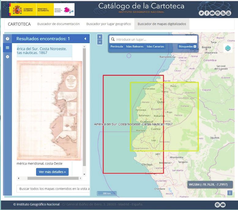
Universitas, Revista de Ciencias Sociales y Humanas de la Universidad Politécnica Salesiana del Ecuador,
                                        No. 33, September 2020-February 2021

Resumen
El presente trabajo analiza la importancia de los geoportales históricos para la apropiada diseminación
del patrimonio cartográfico. Este incluye los artefactos producidos por la cartografía en el pasado. Mu-
chos de estos son frágiles y su conservación se realiza mediante digitalización. Sin embargo, el patrimo-
nio es cultura y por lo tanto no solo debe almacenarse sino también compartirse. El público debe cono-
cer los bienes patrimoniales para que estos puedan transmitir cultura. En este contexto, es necesaria la
creación de medios que efectivamente permitan el acceso a los mapas antiguos digitalizados. El objetivo
de este documento es analizar el valor del patrimonio cartográfico y explorar medios para diseminarlo
efectivamente. Para ello, se presentan varios proyectos desarrollados en Europa para la diseminación
del patrimonio documental y en particular cartográfico. Esto último a través de geoportales históricos.
Diversas instituciones europeas han creado bibliotecas digitales y geoportales históricos. Mas aún, se ha
desarrollado una biblioteca centralizada para acceder a los contenidos de numerosas instituciones del
continente. Si bien, en Iberoamérica se ha creado un proyecto similar, este es limitado al no presentar
los mapas con las funcionalidades requeridas en un geoportal histórico. Se concluye que la creación de
geoportal histórico para los documentos históricos del Ecuador permitiría al público conocer mejor el
patrimonio histórico edificado y fomentar así su gobernanza.

Palabras clave
Mapa, cartografía, patrimonio documental, digitalización, biblioteca digital, difusión de la cultura.

Introduction
    This article introduces the concept of digital libraries for consulting di-
gitized content of an institution. Later, the old cartographic documents that
together make up the so-called cartographic heritage are analyzed. Websi-
tes created for their dissemination are given various names, we will use the
name historical geoportals in this document as they distribute historical geo-
graphic information.
    Through the review of this particular type of digital libraries, we seek to
demonstrate the various efforts made in Europe to disseminate cultural con-
tent and the way in which the cooperation of said institutions and even diffe-
rent countries is possible to create websites with greater content.

                                                         40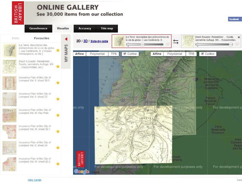
Esteban Xavier Arévalo-Maldonado, Historical geoportals as media for the dissemination of culture

     Having Europe as an area of study has made it possible to reduce the
length of this analysis that would otherwise have required more than a sin-
gle article. The emphasis on this continent is due to the efforts that have
been made there for the preservation and dissemination of cultural heritage
through new technologies. It is also of interest due to the integration efforts
in various areas that have taken place in recent decades among the countries
of the region.
     This review of heritage sites aims to analyze the possibilities that the In-
ternet offers for access to documentary content. Beyond simply consulting
a content catalog, digital libraries provide access to the documents them-
selves. This functionality can serve as inspiration for similar efforts in our
region, with an emphasis on both inter-institutional and international coo-
peration, both in the development of new technologies and in the communi-
cation of experiences, knowledge, and infrastructure.
     Finally, it should be noted that restricting the study to a geographical
area has the limitation of not including cooperation projects in other regions
of the world. A review of projects on other continents could reveal similar
initiatives but adapted to other contexts, realities, and cultures.

Methodology
    First, this document seeks to describe the value of ancient maps, in addi-
tion to placing them within the context of cultural heritage. These concepts
are introduced through a review of the existing literature in the area. As a
result, the need arises for the dissemination of cultural heritage and therefo-
re of cartographic heritage as a tool to reinforce cultural identity but also as
means of raising public awareness about the territory and historical heritage
represented on maps.
    Subsequently, the implementation of digital libraries and historical
geoportals are explored, analyzing their functionality and the context in
which they were developed. Finally, the historical material with geographi-
cal characteristics that exist in Ecuador and that could be integrated into a
historical geoportal is explored.
    As a result, we seek to present the possibilities that currently exist for
the dissemination of cartographic collections on the Internet, both in the ne-
cessary technology and in development strategies.

                                                    41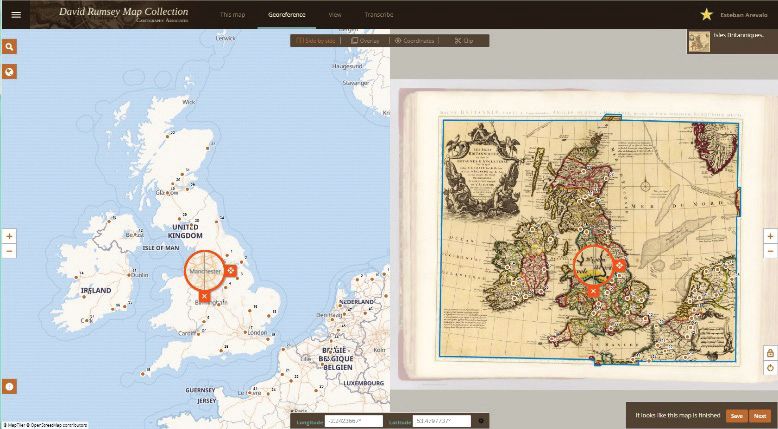
Universitas, Revista de Ciencias Sociales y Humanas de la Universidad Politécnica Salesiana del Ecuador,
                                      No. 33, September 2020-February 2021

Development

Ancient maps
     Maps provide a sense of understanding and control over the territory
they represent. We often view them as unquestionable representations of
reality on the ground, and we rely on them to navigate and make decisions
throughout the day. With the new mobile applications, maps have become
dynamic entities that are updated and traveled at the pace of our needs. In
this panorama, old maps, which no longer represent an up-to-date view of
the territory or which were created long before modern cartography tech-
niques, are seen as obsolete images, perhaps only valid for their decorative
capacity. However, these artifacts from the past can still guide us in our at-
tempt to preserve culture and bring it within the reach of the public.
     Old cartography is mainly made up of maps, but it also includes globes,
sketches, engravings, etc., made in the past and that no longer describe the re-
ality of the area they represent. These cartographic artifacts are mainly drawn
or printed on paper and being old, this material runs the risk of deterioration.
That is why the libraries or institutions that own them create files to store them
physically. However, and given that they can no longer fulfill their function of
illustrating reality, how can these documents be used in the present?
     Ancient cartography is valuable from two perspectives. First, the infor-
mation it represents allows us to know the past and perform historical analy-
sis. Old maps, sketches, or engravings allow us to understand the changes
that the area they represent has undergone. In the case of heritage contexts,
it allows us to know information about the terrain, the landscape, or the buil-
dings that make up the group they represent.
     Second, maps are themselves cultural assets as well. The map provides
information about its creation process and the aspirations of the society that
created it. Therefore, ancient cartography requires more than one analysis of
the information it presents, a critical study to understand our history and bet-
ter assess the environment that surrounds us (Cascón-Katchadourian, Ruiz
Rodríguez, & Román, 2018).
     To achieve this, antique maps must be accessible to the public in settings
suitable for exploring their geographical and artistic qualities.

                                                       42
Esteban Xavier Arévalo-Maldonado, Historical geoportals as media for the dissemination of culture

Cultural heritage
    The modern world presents us with numerous challenges as a society.
The incessant advancement of technology allows us to reduce distances and
be more effective in our tasks. We are in a situation resulting from an incre-
asingly accentuated globalization and commodification of human dynamics.
However, although advances in technology represent an improvement in the
quality of life of the human being, they have not been able to solve problems
of humanity such as inequity in access to economic and cultural goods, eth-
nic or religious conflicts, or the detriment of the culture or history as acces-
sory topics in a world where only knowledge translatable into financial re-
turns is considered useful.
    It is in this context that UNESCO (2014) emphasizes the importance of
cultural heritage. This includes those vestiges of the cultures of the past that
have remained until our time. In the present, in which reality is constantly
transformed, cultural heritage has the virtue of providing us with an anchor,
a sense of security in the face of changes in the world, as well as a sense of
belonging to the environment. In this way, our sense of identity with respect
to our own culture is reinforced.
    Cultural heritage, such as the heritage represented, mainly, by ancient
towns or cities, is a clear example of how this sense of belonging is gene-
rated. In the current context of capitalism, exacerbating the immediacy of
mass consumption, Páez-Barrera (2011) points out that the speed of the use
and disposal of things generates the loss of historical memory. The historic
center of a city then becomes a kind of library of references to the past whe-
re we can find answers about who we are and what our history and culture is.
    Additionally, UNESCO (1982) points out that access to other cultures
allows us to contrast and enrich our values by nurturing our own culture and
keeping it dynamic and alive. It also emphasizes that the enjoyment of cul-
ture should not be the privilege of an elite. Instead, cultural heritage must be
disseminated and enjoyed by all, generating a cultural democracy.

Cartographic heritage
    Since it was conceived and until the 1970s, the concept of cultural he-
ritage mainly encompassed old buildings (UNESCO, 1972). However, the
concept has expanded to include all entities that support memory (Interna-

                                                    43
Universitas, Revista de Ciencias Sociales y Humanas de la Universidad Politécnica Salesiana del Ecuador,
No. 33, September 2020-February 2021
tional Conference on Conservation, 2000). In this context, the concept of
cartographic heritage arises, made up of maps and other artifacts produced
by cartography. Given that they support memory, as (Hruby et al., 2006)
affirm, cartographic heritage is a cultural heritage worthy of being conser-
ved for the future.
New challenges arise from this approach in the administration of old car-
tography. In the libraries and institutions where maps and other cartographic
artifacts are stored, a process of storage, organization, and conservation of ori-
ginal documents has been developed. However, the heritage status that these
objects have, means that their administration requires additional actions.
Livieratos (2008) regarding the efforts of the International Cartographic
Association regarding the management of cartographic heritage, identifies
additional tasks of administration of old maps. First, as has been done befo-
re, the map requires that its material version be preserved, restored, and pro-
tected so that it remains available for future generations. Additionally, being
an element that helps to explore the past, the contents of the map need to be
studied in a process that allows their understanding and interpretation. Fina-
lly, as culture is a universal right, the map requires a communication process
that allows its access and dissemination to the public.
When it comes to the original material, these tasks are carried out in di-
fferent environments and through different strategies. The preservation of
the original is carried out by experts in the handling of antiques. The study
of the document is carried out in the institution by experts who gain access
to the document. Finally, communication to the public takes place through
exhibitions of facsimiles or copies of maps or in a limited way in museums.
At present, the preservation of cartographic heritage can also be achie-
ved through the creation of digital copies, which no longer present the risks
of deterioration and destruction of the support material as occurs with the
original copies. Then, thanks to georeferenced systems (GIS), analysis and
studies can be carried out on the digitized map. Finally, through the creation
of digital galleries, access to cartographic material can be allowed.
Historical geoportals
There is abundant literature regarding historical study projects suppor-
ted by ancient maps. However, in most cases, although the map is the basis
44Esteban Xavier Arévalo-Maldonado, Historical geoportals as media for the dissemination of culture
for obtaining results and drawing conclusions, its analysis in the GIS envi-
ronment remains accessible only to the researcher. In such cases, the task of
disseminating this cartographic heritage remains pending. For this, Internet
sites are required to present the maps as historical geographic information.
For this reason, they can be called historical geoportals.
Additionally, as they are heritage objects, the way they are presented
should emphasize the fact that these maps describe a reality from the past.
(Livieratos, 2008) referring to (Chippindale, 2007) remarks that what makes
heritage different from archeology is the fact that the former is related to
how elements of the past are seen and understood today in our time. In the
case of maps, this contrast can be achieved by comparing the geographic
area represented in the cartographic artifact with a modern map.
Ancient maps to understand the territory
Governance consists of the exercise of political power from the articula-
tion of government entities, society and the private sector. In this way, citi-
zens become participants in the generation and application of public policies
(Herrera-Franco, 2016). Regarding the administration of heritage, gover-
nance allows citizens to become agents of protection of the heritage envi-
ronments in which they live.
UNESCO (2014) observes that if the community actively participates
in the generation of a management strategy and its execution, less external
controls, and monitoring will be required. Furthermore, heritage contributes
to the well-being and happiness of individuals, to environmental sustainabi-
lity, and potentially to the increase of social and economic capital.
However, for both authorities and citizens to manage heritage assets,
they need to know their history. This way they can determine its authenticity
and subsequently its integrity. Documents such as old maps, but also photo-
graphs, books, and other texts help in this task. Additionally, knowledge of
history generates a greater sense of belonging and identity in citizens.
Cartographic heritage in the digital world
As mentioned, the administration of cartographic heritage is currently
facilitated by computer systems. To achieve this, a series of requirements is
45Universitas, Revista de Ciencias Sociales y Humanas de la Universidad Politécnica Salesiana del Ecuador,
No. 33, September 2020-February 2021
necessary, starting with the digitization of the original documents. Later, as
Cascón-Katchadourian et al. (2018b) explain, the georeferencing and web
publishing processes allow creating environments where the maps can be
compared with a modern counterpart and, at the same time, be accessible
both by the general public and by researchers interested in these documents.
These steps will be reviewed below.
Digitalization
Ancient maps in their original material support are fragile. These do-
cuments printed or drawn on paper or similar materials are susceptible to
destruction either by use or by natural elements. To prevent this, the insti-
tutions in charge of the original copies digitize their contents. This implies
a logistical challenge, for these institutions, that can be effectively assumed
by encouraging public policies that promote the preservation and dissemi-
nation of cultural content, articulating the work of cultural and academic
organizations.
In Europe, for example, the potential to handle digitized cultural content
has been seen since the popularization of the computer. Already in 1984, the
European Parliament aware of the importance of libraries to achieve real so-
cial progress in the countries of the European Union approved the Schwenc-
ke resolution with the intention of creating a unified European library. This
was followed by an action plan in 1989 which included the introduction of
the latest bibliographic technologies and standards, but also fostered coope-
ration between institutions to share resources and create contact networks.
These objectives were later put into practice in various action projects in the
following years (Chen, 2012).
In particular, at the technological level, the European Union saw the ad-
vantages and potential of the digital environment. For this reason, it has su-
ggested the preservation of heritage assets through their digitization (The
European Commission, 2011). As a result of this vision, the Union encou-
rages the creation of public policies in member countries to make efforts in
this regard.
Additionally, it is suggested that the member states allow the coopera-
tion of their institutions related to heritage management so that they work
together, exchange technologies, and share equipment and experiences. It
46Esteban Xavier Arévalo-Maldonado, Historical geoportals as media for the dissemination of culture
is pointed out the importance of this cooperation to enrich the process and
in turn avoid duplication of efforts. With this precedent in Europe, there
was a joint work process of various institutions to achieve the objectives
of digitization and dissemination of cultural assets. One of the results of
these efforts was the creation of a website by the conference of European
national libraries (CENL): The European Library. This site housed more
than 28 million images of heritage elements from 48 national libraries
(CENL, 2016).
Figure 1
The European Library
47Universitas, Revista de Ciencias Sociales y Humanas de la Universidad Politécnica Salesiana del Ecuador,
No. 33, September 2020-February 2021
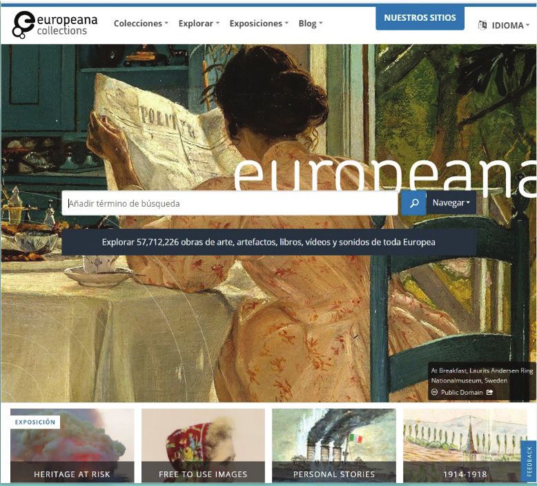
The success of this portal led the European Commission to continue
the project with a new website: European collections. This portal presen-
ted in Figure 1, collects more than 57 million digital images of pieces of art,
books, films, and other artifacts from museums, galleries, libraries, and ar-
chives of the countries of the European Union (The European Commission,
2011), (European Union, 2019). A large part of the contents of The Euro-
pean Library was integrated into the new site since the digitization and sto-
rage of the images were made based on standards compatible with the new
site. However, despite cooperation, there are still disparities between mem-
ber countries, with per capita expenditure for libraries ranging from € 35 in
Denmark to € 9 in Bulgaria (Chen, 2012). Cooperation, then, does not solve
the problems but is a starting point despite the differences.
Georeferencing
Georeferencing an old map consists of assigning it a modern coordinate
system that allows it to be combined with other cartographic representations
or with geographic data from the same area. This means that the ancient
map can be embedded on top of a modern one, such as the one from Google
Maps, and combined with other ancient maps of the same area or with other
geographic information such as environmental or urban data (Cascón-Kat-
chadourian, Ruiz-Rodríguez, et al., 2018b).
This process is generally carried out using Geographic Information Sys-
tems (GIS). In the case of ancient maps, georeferencing requires knowing
a series of reference points on the map and also their location on a modern
map with a cartographic projection (Dávila & Camacho Arranz, 2012). The
landmarks can be buildings, crossroads, islands, or any other entity that is
recognizable on the two maps.
However, georeferencing imposes additional requirements on digitiza-
tion. This requires that deformations on the map surface be minimized when
digitizing. For the digital copy to reflect the contents of the original map, it
is also necessary to preserve the colors of the map and its original scale (Li-
vieratos, 2008).
There are tools that allow georeferenced maps that are already publis-
hed. Furthermore, it is possible to allow users of a digital map gallery to ca-
rry out the process. One of the best known and most complete tools for this
48Esteban Xavier Arévalo-Maldonado, Historical geoportals as media for the dissemination of culture
process is Georeferencer (Cascón-Katchadourian et al., 2018a) (Fleet et al.,
2012). Figure 2 presents this tool which requires a payment for its imple-
mentation on a website.
Figure 2
Georeferencer
Search
In digital libraries, the search for texts is carried out using keywords.
The process scans the contents or metadata of documents and books in the
library and returns the items that match. Searching for cartographic mate-
rials only on the basis of text means using only the toponyms or place names
that are represented on the map and that have been added to the document
metadata. This however is not optimal as those names may repeat themsel-
ves, change over time, or the map may include only a few associated names
for searching. Therefore, the maps require different treatments.
Instead of searching by text, it is possible to perform a geographical
search. This is done on a modern world map on which one can increase the
scale to get closer to a certain area. A series of rectangles outline the cove-
rage of the maps that partially or totally represent the selected area on the
screen (Oehrli et al., 2011).
49Universitas, Revista de Ciencias Sociales y Humanas de la Universidad Politécnica Salesiana del Ecuador,
No. 33, September 2020-February 2021
The MapRank indexing mechanism stands out as an implementation
of geographic search. (Oehrli et al., 2011; Cascón-Katchadourian et al.,
2018a). Examples of the implementation of a map search based on the area
they represent are the map library of the National Geographic Institute of
Spain (IGN, 2019) and the OldMapsOnline project. Here the modern world
map allows us to retrieve digitized maps according to the area that is maxi-
mized on the screen (Figure 3).
Figure 3
National Geographic Institute of Spain
Publication
GIS environments have allowed projects to be created based on histo-
rical geographic information including ancient maps. In these applications,
50Esteban Xavier Arévalo-Maldonado, Historical geoportals as media for the dissemination of culture
researchers can store, analyze, interpret, and present this information. Pro-
jects of this type, oriented mainly to history, are called historical GIS (Gre-
gory & Healey, 2007; Offen, 2013). However, many of these applications
are unpublished and are used only by researchers.
GIS have been desktop applications since their inception. Although
ESRI, the leading GIS company with its ARCGIS system, has already de-
veloped a web version, georeferenced systems are not optimal for public
use due to their complexity and, as in the case of ARCGIS, because of their
cost. It is therefore necessary to create web portals that allow the maps to be
published on the Internet and provide them with the necessary functionality
for their correct interpretation and analysis by the public. On the other hand,
such websites should be simple and lightweight in contrast to the diverse
provision of controls available in a GIS. Furthermore, technologies such as
Google Maps or Open Street Maps have changed the expectations of map
users, who expect versatile and interactive applications.
For all this, limiting themselves to the creation of digital galleries to pre-
sent maps on the internet, detracts from the potential they have when they
are handled in GIS environments. Therefore, map sites must have additional
functionality to make use of georeferencing and allow the search and dis-
play of the map not only as an image but also as geographic information, re-
presented on a modern map by using its coordinates.
Following the efforts of the European Library and Europeana, in 2008
the DIGMAP project was launched. This included a series of modules for
indexing and consulting old maps, based on place names or other data in the
document. It was funded in part by the European Commission and was ex-
pected to be Europe’s main map repository (Borbinha et al., 2007). Howe-
ver, once the time allotted to the project had ended, it was not continued. In
its place, other initiatives have emerged in European countries such as the
map library of the National Geographic Institute of Spain (IGN, 2019), (Ra-
dovan & Šolar, 2010), the National Library of Scotland (National Library
of Scotland, 2019) or the British Library (The British Library, 2019) whose
historical geoportal appears in Figure 4.
51Universitas, Revista de Ciencias Sociales y Humanas de la Universidad Politécnica Salesiana del Ecuador,
No. 33, September 2020-February 2021
Figure 4
The British Library
A case of cooperation between European institutions is the Old Maps
Online project (Klokan Technologies, 2019). This consists of a web portal
to search for maps based on your coverage area. This system, developed in
open source, brings together the collections of various institutions throug-
hout Europe such as national libraries and universities. A map coverage area
search tool allows searching for maps that are not georeferenced and whose
original website only implements text searches. Additionally, it is possible
to concentrate various types of content in a single interface, reducing imple-
mentation efforts in the other participating institutions. However, this colla-
boration is possible due to the fact that the institutions handle similar stan-
dards for their content.
52Esteban Xavier Arévalo-Maldonado, Historical geoportals as media for the dissemination of culture
Figure 5
Old Maps Online
In order to support this interoperability, the European Commission (The
European Commission, 2011) recommends that institutions develop digital
galleries for their cultural assets, the use of standards for digitization, and
the creation of metadata.
Ancient cartography in Ecuador
Ancient maps
The maps in their modern conception arise with the concepts created in
classical Greece by Ptolemy (Harley & Woodward, 1987). Since then and
with ups and downs, cartographic production has represented Europe, Asia
and Africa on countless maps and navigation charts. However, it is not un-
til the year 1500 that a map by the cartographer Juan de la Cosa includes
the first representation of the American continent (Martín-Merás Verdejo,
53Universitas, Revista de Ciencias Sociales y Humanas de la Universidad Politécnica Salesiana del Ecuador,
No. 33, September 2020-February 2021
2000). Thus, the cartographic production representing the regions of Ame-
rica covers approximately the last 500 years, restricting the analysis of old
maps to this period.
In the case of Ecuador, colonial maps are scarce and mainly represent
representations of large regions of South America. Only in 1927 with the
creation of the Military Geographical Service, the forerunner of the Military
Geographical Institute (IGM), did a methodical mapping of the Ecuadorian
territory begin (León-Pazmiño et al., 2016). Since then, maps in Ecuador
have helped create a perception of the nation. However, as has been com-
mented on the nature of the map, its creation, and use has been politicized
and these cartographic elements have not been neutral scientific instruments
(Capello, 2010).
The maps of Ecuador have been compiled and analyzed in various pu-
blications. From reviews of colonial maps, seen only as scientific works as
in Latorre (2017), to more complex analyzes such as that of Sevilla-Pérez
(2013) or Capello (2010) whom go through all the national cartographic ma-
terial. In the latter, although there is a critical analysis of the maps and their
particularities, the images of the maps are accessory elements, and the re-
duced format of their reproduction prevents an analysis beyond that already
carried out in the text. Several projects have compiled old maps for geore-
ferencing and presentation as a gallery (Reyes et al., 2017). However, the-
se have been one-off projects and have not received additional functionality
after their creation.
Historical geoportals
Unlike Europe, in developing countries, the introduction of information
and communication technologies in libraries has been slow. This is due to
the fact that there are many other needs to cover, from pressing issues such
as the fight against illiteracy, to more specific tasks such as the protection of
original documents in cultural institutions. The creation of digital galleries
thus faces challenges due to lack of resources, but also other barriers such as
language, with a clear majority of software environments being in English
or logistics such as limited Internet access in certain regions.
International cooperation between institutions, as in the case of Europe,
can help to largely solve such problems (Alpay-Aslan, 2012). An example
54Esteban Xavier Arévalo-Maldonado, Historical geoportals as media for the dissemination of culture
of integration between libraries in our region is the Ibero-American Natio-
nal Libraries Association (ABINIA) of which various institutions in Ecua-
dor are part. For this association, the National Library of Spain (BNE) has
created a web portal called the Ibero-American Heritage Digital Library
(ABINIA, 2019). This unified portal allows access to the catalog index cards
of the contents of the institutions or, in some cases, to a digital version of the
same, depending on the institution that has the original document. Although
there are various maps among the digital content that this portal offers, these
still require a higher quality of digitization than the functionalities described
above for exploring maps.
Cuenca
Most of the cartographic material of Ecuador throughout the colony and
during the 19th century corresponded mainly to national or regional maps.
However, the city of Cuenca was represented in diagrams and sketches (Al-
bornoz & Achig-Subía, 2008). For more recent years there are more detailed
maps and cadastral information. These documents have a geographic ele-
ment and their digitized copies could be georeferenced and integrated into
a GIS environment.
The city of Cuenca has the status of cultural heritage of humanity. As a
result, efforts have been made to register heritage assets and monitor their
status. However, Heras et al. (2016) pointed out that the collection of in-
formation related to heritage was carried out in different periods of time
and by different institutions, creating great heterogeneity in the type of data
and making it impossible to combine them. Additionally, they suggested the
need to create a centralized environment for this information.
Subsequently, a unified system for support in decision-making on heri-
tage assets was implemented with information on each infrastructure and its
state of conservation (Siguencia-Ávila & Rey-Pérez, 2016). However, said
application does not make use of historical resources such as maps or photo-
graphs. Additionally, it is implemented in a GIS system and is not published
on the web. Therefore, it is intended only for the internal use of the institu-
tions in charge of managing the assets.
55Universitas, Revista de Ciencias Sociales y Humanas de la Universidad Politécnica Salesiana del Ecuador,
No. 33, September 2020-February 2021
Additional contents
In addition to the ancient cartography, there are other historical ele-
ments that can obtain a geographical reference. (Cascón-Katchadourian et
al., 2018a) explain that other digitized historical elements such as photogra-
phs, posters, sketches, etc., can represent a geographical place and therefore
can be assigned to a certain pair of coordinates.
Various historical material is found in the archives of the institutions of
Ecuador. For example, the IGM has physical copies of its cartographic pro-
ductions (León-Pazmiño et al., 2016) and other institutions have created di-
gital repositories of their collections such as the National Institute of Cul-
tural Heritage (INPC, 2015). These documents could be integrated into a
historical geoportal that allows the public to search, compare, and contrast
the contents according to their geographical location. In this way, the expe-
rience is maximized and visitors are allowed to browse the contents in an
orderly manner, either chronologically or geographically.
Conclusions
In Europe, various tools have been created for the dissemination of do-
cumentary heritage, including cartographic, using the latest technologies for
the development of web environments. These portals have arisen both at the
initiative of the institutions and as a result of a state stimulus and based on
public policies aimed at the dissemination of culture and inter-institutional
collaboration. This in turn is the result of a process of integration between
countries within the European Union.
Inter-institutional cooperation policies have allowed more than the par-
ticipation of various institutions in the development of tools, the exchange
of knowledge and technology. This achieves standardized and higher quali-
ty results with less effort.
In Ecuador, various public and private institutions have historical ma-
terial such as maps, but also sketches, plans, photographs, etc. These docu-
ments represent a place on the surface and can be associated with geographic
coordinates. Therefore, this documentary heritage could be incorporated
into a historical geoportal that pools together the funds of various institu-
tions emulating similar projects such as those reviewed in this article.
56Esteban Xavier Arévalo-Maldonado, Historical geoportals as media for the dissemination of culture
The creation of a web environment that allows access to historical docu-
ments for Ecuador would have the benefit of allowing us to know the history
of the place where we live, but also to value the heritage that still remains,
the testimony of the past. This is of particular relevance for cities with a he-
ritage character such as Cuenca, where historical documentary collections
play a fundamental role in making their citizens aware of the history of the
place where they live and the value of the cultural heritage of their man-ma-
de environment. Only with this knowledge can effective governance of the
heritage be carried out by its inhabitants.
Bibliography
ABINIA (2019). Biblioteca Digital del Patrimonio Iberoamericano. https://bit.
ly/34hPTPV
Albornoz, B., & Achig-Subía, L. (2008). Planos e imágenes de Cuenca. I. Munici-
palidad de Cuenca. https://bit.ly/3hfc39h
Alpay-Aslan, S. (2012). 1.5 Use of Technology in Libraries in the European Union
Towards 2020. In Libraries in the early 21st century. Volume 2: an inter-
national perspective.
Borbinha, J., Pedrosa, G., Reis, D., Luzio, J., Martins, B., Gil, J., & Freire, N. (2007).
DIGMAP – Discovering Our Past World with Digitised Maps. In Research
and Advanced Technology for Digital Libraries (pp. 563-566). Springer
Berlin Heidelberg. https://doi.org/10.1007/978-3-540-74851-9_70
Capello, E. (2010). Mapas, obras y representaciones sobre la nación y el territo-
rio. De la corografía al Instituto Geográfico Militar. En V. Coronel y M.
Prieto (Eds.), Celebraciones centenarias y negociaciones por la nación
ecuatoriana. FLACSO Ecuador. https://bit.ly/3aFcuXV
Cascón-Katchadourian, J., Ruiz-Rodríguez, A.Á., & Alberich-Pascual, J. (2018a).
Uses and applications of georeferencing and geolocation in old carto-
graphic and photographic document management. El Profesional de La
Información, 27(1), 202. https://doi.org/10.3145/epi.2018.ene.19
Cascón-Katchadourian, J., Ruiz Rodríguez, A., & Román, A. Q. (2018b). Georre-
ferenciación y publicación web de cartografía antigua en sistemas de in-
formación geográficos: requisitos para su evaluación y estudio de caso.
Rev. Gen. Inf. Doc, 28(1), 193-212. https://doi.org/10.5209/RGID.60810
CENL (2016). The European Library. https://bit.ly/2CPlXzq
57Universitas, Revista de Ciencias Sociales y Humanas de la Universidad Politécnica Salesiana del Ecuador,
No. 33, September 2020-February 2021
Chen, C. (2012). 1.3 Technology Enabling Universal Access to World Heritage:
Implications for Libraries. In R. N. Sharma (Ed.), Libraries in the early
21st century. Volume 2: an international perspective. De Gruyter Saur.
Chippindale, C. (2007). The oldest heritage: Mediterranean Classical, in a view from
the north, and the heritage model it has created. In S. Antoniadou y A. Pace
(Eds.), Mediterranean Crossroads (pp. 741-67.). Pierides Foundation.
Conferencia Internacional en Conservación (2000). Carta de Cracovia 2000 Prin-
cipios para la conservación y restauración del patrimonio construido. In
Cracovia 2000 (p. 6). Cracovia. https://bit.ly/31et25S
Dávila, F.J., & Camacho-Arranz, E. (2012). Georreferenciación de documentos car-
tográficos para la gestión de archivos y cartotecas: propuesta metodoló-
gica. Revista Catalana de Geografía, XVII(46), 9. https://bit.ly/3iXjt13
European Union (2019). Europeana Collections. https://bit.ly/3iR12eC
Fleet, C., Kowal, K.C., & Pridal, P. (2012). Georeferencer: Crowdsourced Geo-
referencing for Map Library Collections. D-Lib Magazine, 18(11/12).
https://doi.org/10.1045/november2012-fleet
Gregory, I.N., & Healey, R.G. (2007). Historical GIS: structuring, mapping and
analysing geographies of the past. Progress in Human Geography, 31(5),
638-653. https://doi.org/10.1177/0309132507081495
Harley, J.B., & Woodward, D. (1987). Preface. In D. Harley, John Brian Woodward
(Ed.), History of Cartography: Volume One - Cartography in prehistoric,
ancient, and medieval Europe and the mediterranean (p. 7). University
of Chicago Press. https://bit.ly/34jxwKq
Heras, V., Barsallo-Chávez, M.G., Abril, C., & Briones, J.C. (2016). Heritage in-
ventory as the base for a monitoring system in the world heritage city
of Cuenca. In Structural Analysis of Historical Constructions: Anamne-
sis, Diagnosis, Therapy, Controls (pp. 181-184). CRC Press. https://doi.
org/10.1201/9781315616995-23
Herrera-Franco, G. (2016). La Importancia de la Gobernanza Participativa y su
Incidencia en el Desarrollo Local. FCSHOPINA, 89, 5. https://bit.
ly/2ElNdG9
Hruby, F., Plank, I., & Riedl, A. (2006). Cartographic heritage as shared experience
in virtual space: A digital representation of the earth globe of Gerard
Mercator (1541). E-Perimetron, 1(2), 88-98. https://bit.ly/31gyDsy
IGN (2019). Catálogo de la cartoteca del IGN. https://bit.ly/3hhl8y3INPC. (2015).
Fondo Nacional de Fotografía. (http://fotografiapatrimonial.gob.ec/web/
es) (2019-07-18)
58Esteban Xavier Arévalo-Maldonado, Historical geoportals as media for the dissemination of culture
Klokan Technologies (2019). OldMapsOnline. https://bit.ly/31g0QQ5
Latorre, O. (2017). Los primeros mapas del país. Ecuador Terra Incognita, 32-41.
León-Pazmiño, F., Narváez, R., & Rubio, M.L. (2016). 87 años de Generación Car-
tográfica en el Ecuador, Información y Comunicación. 6a Simposio Ibe-
roamericano de Historia de la Cartografía. Santiago, Chile. https://doi.
org/10.13140/RG.2.1.1993.0483
Livieratos, E. (2008). The challenges of Cartographic Heritage in the digital world.
In Third International Workshop Digital Approaches to Cartographic
Heritage (p. 7). https://bit.ly/3iSoU1k
Martín-Merás, M. (2000). La Carta de Juan de la Cosa: interpretación e historia.
Monte Buciero, (4), 71-86.
National Library of Scotland (2019). National Library of Scotland. Map Images.
https://bit.ly/2Qa9tFx
Oehrli, M., Zollinger, S., Siber, R., & Přidal, P. (2011). MapRank: Geographi-
cal Search for Cartographic Materials in Libraries. D-Lib Magazine,
17(9/10). https://doi.org/10.1045/september2011-oehrli
Offen, K. (2013). Historical geography II. Progress in Human Geography, 37(4),
564-577. https://doi.org/10.1177/0309132512462807
Páez-Barrera, O. (2011). Ver lo mismo, pero con otros ojos: iconografía
arquitectónica de la Cuenca histórica. Revista Pucara. Universidad de
Cuenca. https://bit.ly/2FAOycA
Radovan, D., & Šolar, R. (2010). Geospatialization and Socialization of Cartogra-
phic Heritage. In M. Jobst (Ed.), Preservation in Digital Cartography
(pp. 161-178). Springer Berlin Heidelberg. https://doi.org/10.1007/978-
3-642-12733-5_8
Reyes, D., Salgado-Chávez, P., & Padilla, O. (2017). Georreferenciación de mapas
históricos de Sudamérica para el desarrollo de una galería de mapas web.
Conferencia Iberoamericana de Sistemas de Informacion Geografica.
Cuenca, Ecuador. https://bit.ly/2EkPDos
Sevilla-Pérez, A.M. (2013). El Ecuador en sus mapas. FLACSO. https://bit.
ly/2Q8zfd5
Siguencia-Ávila, M.E., & Rey-Pérez, J. (2016). Heritage values protection, from
the monument to the urban dimension. Case study: the historic centre of
Santa Ana de los Ríos de Cuenca, Ecuador. The Historic Environment:
Policy & Practice, 7(2-3), 164-176. https://doi.org/10.1080/17567505.2
016.1172785
The British Library (2019). British Library, online gallery. https://bit.ly/3lalCJ1
59Universitas, Revista de Ciencias Sociales y Humanas de la Universidad Politécnica Salesiana del Ecuador,
No. 33, September 2020-February 2021
The European Commmission (2011). Commission Recommendation of 27 October
2011 on the digitisation and online accessibility of cultural material and
digital preservation. Brussels, Belgium. https://bit.ly/2E2ZEa9
UNESCO (1972). Convention Concerning the Protection of the World Cultural and
Natural Heritage. Paris. https://bit.ly/3aKh9Yk
UNESCO (1982). World Conference on Cultural Policies. World Conference on
Cultural Policies: final report (p. 236). Mexico City: UNESCO Digital
Library. https://bit.ly/32biaVK
UNESCO (2014). Gestión del patrimonio mundial cultural. https://bit.ly/3aH67TT
Submission date: 2019/12/28; Acceptance date: 2020/08/19;
Publication date: 2020/09/01
60You can also read