Hunter Project - January 2021 - Kenorland Minerals
←
→
Page content transcription
If your browser does not render page correctly, please read the page content below
Hunter Project – January 2021
Disclaimer and Qualified Person
 Forward Looking Statements

 •   This document includes certain statements that constitute “forward-looking statements” and “forward-looking information” within the meaning
     of applicable securities laws (collectively, “forward-looking statements”). Forward-looking statements include statements regarding Kenorland
     Minerals Ltd. (“Kenorland”) intent, or the beliefs or current expectations of Kenorland’s officers and directors. Such forward-looking statements
     are typically identified by words such as “believe”, “anticipate”, “estimate”, “project”, “intend”, “expect”, “may”, “will”, “plan”, “should”, “would”,
     “contemplate”, “possible”, “attempts”, “seeks” and similar expressions. Forward-looking statements may relate to future outlook and anticipated
     events or results.

 •   By their very nature, forward-looking statements involve numerous assumptions, inherent risks and uncertainties, both general and specific, and
     the risk that predictions and other forward-looking statements will not prove to be accurate. Do not unduly rely on forward-looking statements,
     as a number of important factors, many of which are beyond Kenorland’s control, could cause actual results to differ materially from the
     estimates and intentions expressed in such forward-looking statements.

 •   Forward-looking statements speak only as of the date those statements are made. Except as required by applicable law, Kenorland does not
     assume any obligation to update, or to publicly announce the results of any change to, any forward-looking statement contained herein to reflect
     actual results, future events or developments, changes in assumptions or changes in other factors affecting the forward-looking statements.

 Qualified Person’s Statement

 •   Janek Wozniewski, P.Geo., OGQ, Exploration Manager for Kenorland, is the Qualified Person as defined by National Instrument 43-101,
     Standards of Disclosure for Mineral Projects. Mr. Wozniewski is responsible for the scientific and technical data presented herein and has
     reviewed and approved this project summary. Of note, historical results reported herein have not been verified by Kenorland personnel. Surface
     grab samples are selective by nature and are unlikely to represent average grades of the mineralization found on the property.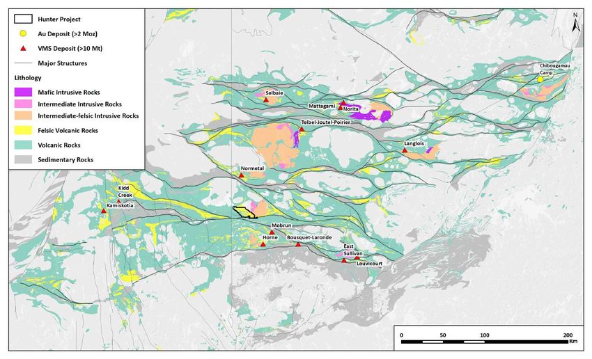
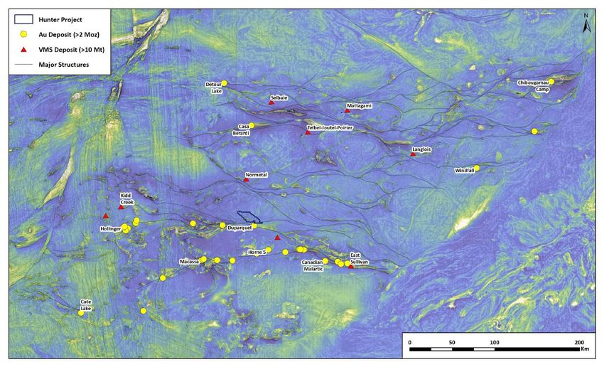
Abitibi Greenstone Belt Geology
                                  •   Abitibi Greenstone Belt (AGB) is the

                 ONTARIO
                 QUEBEC
                                      2nd largest Au-endowed district in
                                      the world (~280 Moz endowment)

                                  •   AGB also one of the largest VMS
                                      districts in the world (>750 Mt
                                      endowment)

                                  •   Two distinct styles of Au
                                      mineralization: orogenic Au &
                                      intrusion-related Au (including Au-
                                      VMS, porphyry-Au)

                                  •   At least four temporal Au events, two
                                      significant events include:
                                        – Orogenic Au – Northern Abitibi
                                            ~2700 Ma; Southern Abitibi
                                            ~2670 Ma
                                        – Syn-volcanic intrusion-related
                                            Au – 2740 Ma (Cote Lake); 2720
                                            Ma (Chibougamau); 2697 Ma
                                            (Blake River)

                                                                             3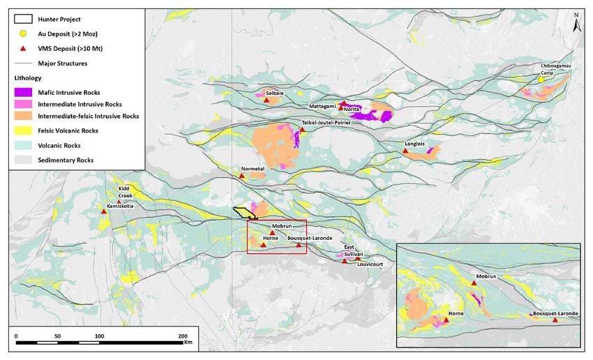
Abitibi Greenstone Belt Magnetics
                                    •   Curvilinear E-W trending

                 ONTARIO
                 QUEBEC
                                        deformation zones expressed as
                                        major lineaments in magnetic data
                                        control much of the orogenic gold
                                        endowment

                                    •   Early syn-volcanic aged Au deposits
                                        also found proximal to major E-W
                                        deformation zones

                                    •   The Hunter Project is situated
                                        adjacent to (north side) of the
                                        Porcupine-Destor Deformation Zone

                                                                              4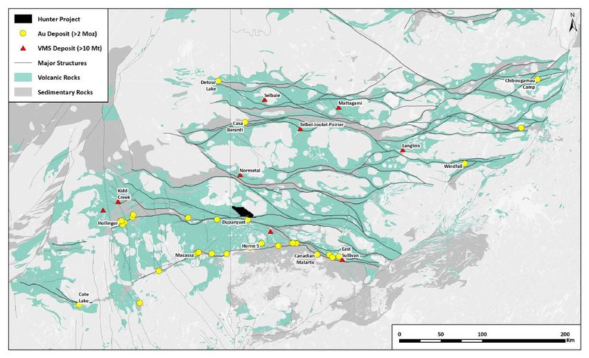
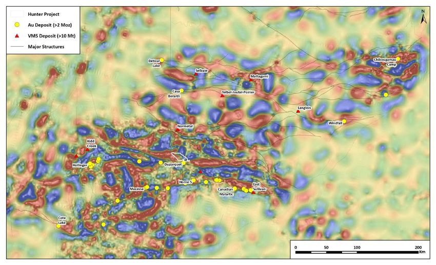
Abitibi Greenstone Belt Gravity
                                  •   Gravity – Bouger anomaly map with

                 ONTARIO
                 QUEBEC
                                      high-pass filter applied to enhance
                                      upper-crustal contrasts

                                  •   Steep gravity gradients are located
                                      along the length of major E-W
                                      trending deformation zones
                                      representing steep, deep-penetrating
                                      structures prospective for gold

                                  •   The Hunter project sits on a steep
                                      gravity gradient associated with the
                                      Porcupine-Destor Deformation Zone

                                                                             5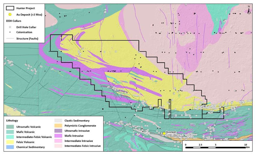
Abitibi Greenstone Belt Volcanic Assemblages
                                               •   Most of the VMS camps in the

                 ONTARIO
                 QUEBEC
                                                   northern Abitibi are located on the
                                                   Deloro – Stoughton-Roquemaure
                                                   stratigraphic contact

                                               •   Deloro to Stoughton-Roquemaure
                                                   transition is a rifted arc setting

                                               •   Rifted arcs have been found to have
                                                   more precious metal enrichment in
                                                   VMS systems (Mercier-Langevin, TGI-5)

                                               •   Deloro – (10 Ma) – Calc-alkaline mafic
                                                   to felsic volcanic rocks capped by iron
                                                   formations

                                               •   Stoughton-Roquemarue (3 Ma) –
                                                   Tholeiitic basalts/komatiites +/- felsic
                                                   volcanics

                                                                                              6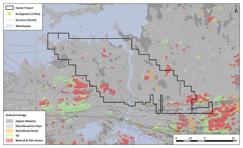
Abitibi Greenstone Belt Syn-volcanic plutons with VMS/porphyry systems
                                                       •   Hunter Exploration Target: syn-

                 ONTARIO
                                                           volcanic intrusion-related Au and Au-

                 QUEBEC
                                                           rich VMS

                                                       •   All syn-volcanic intrusions associated
                                                           with Au-VMS, porphyry-Au, and base
                                                           metal VMS have a mafic component
                                                           (i.e. diorite or gabbro)

                                                       •   Spatial (and genetic?) association of
                                                           Au-rich systems with diorite-tonalite-
                                                           trondhjemite intrusive complexes

                                                           – The Hunter project is adjacent to
                                                             the syn-volcanic, diorite-granite-
                                                             tonalite-trondhjemite Poularies
                                                             Pluton

                                                       •   N-S trend in VMS-associated syn-
                                                           volcanic intrusions (Noranda, Hunter,
                                                           Normetal, Telbel, Selbaie)

                                                                                                  7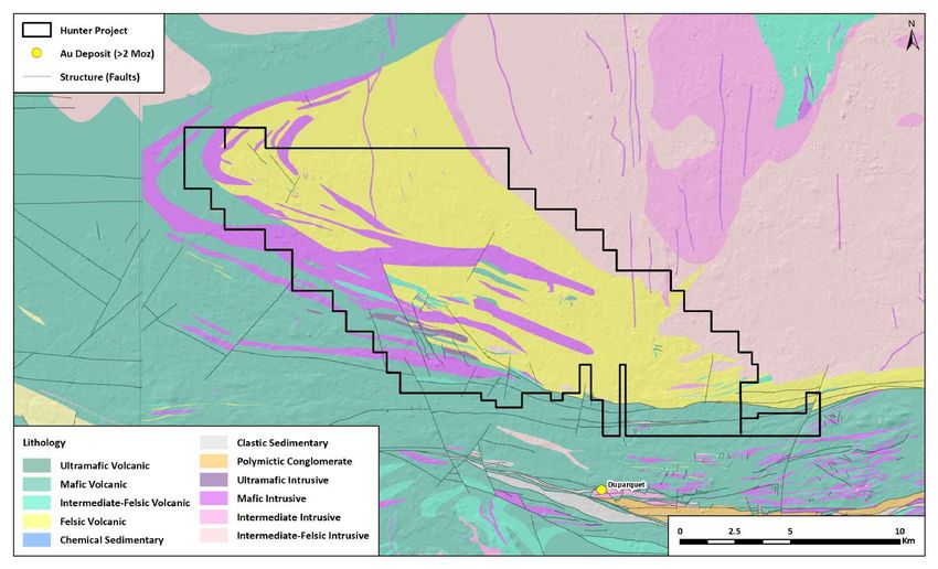
Abitibi Greenstone Belt Calderas
                                                                                 •   Five recognized calderas in the

                                      ONTARIO
                                      QUEBEC
                                                                                     Abitibi (Selbaie, Gemini, Normetal,
                                                                                     Hunter, and Noranda)
                                                     Selbaie caldera – 2728 Ma

                                                                                 •   All of the recognized caldera systems
                                                                                     host significant mineral deposits

                                                    Gemini caldera – 2735 Ma     •   Calderas form in calc-alkaline
                                                                                     settings with evolved magmas
        Normetal caldera – 2725 Ma

                                                                                 •   Evolved calc-alkaline volcanics are
 Hunter Mine caldera – 2730-2720 Ma                                                  more prospective for Au-rich
                                                                                     intrusion-related systems in the
                                                                                     Abitibi (Mercier-Langevin, TGI-5)
                                                Misema / New Senator/ Noranda
                                                calderas – 2707-2696 Ma

                                                                                                                           8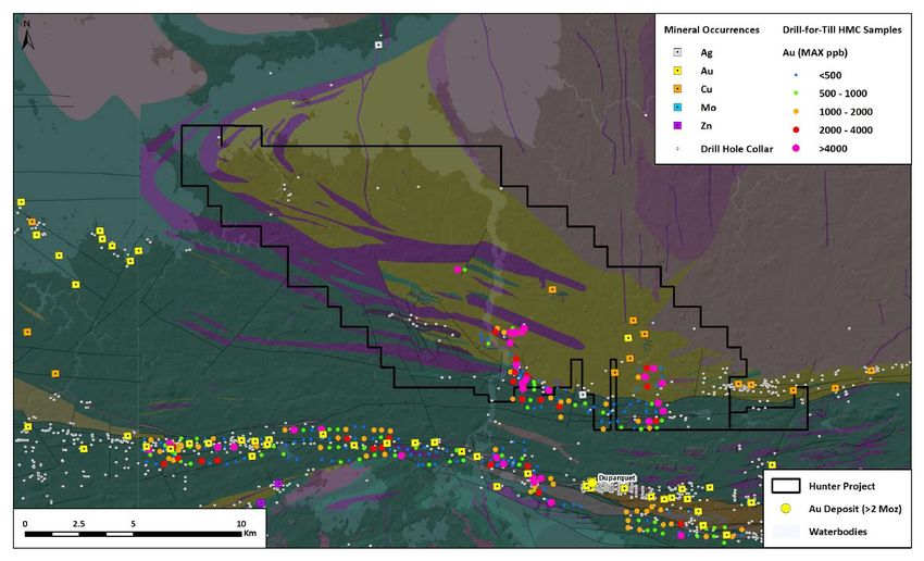
Hunter Geology
                 •   The underlying geology of the Hunter
                     property is dominantly felsic
                     volcanics and volcaniclastics of the
                     Deloro volcanic assemblage
  ONTARIO
  QUEBEC

                      –   Flanked by the syn-volcanic
                          Poularies pluton (diorite-
                          granite-tonalite-trondhjemite)
                          to the east and surrounded by
                          Stoughton-Roquemaure
                          tholeiites to the west and south

                 •   Felsic volcanic package includes
                     brecciated and massive flows,
                     hyaloclastic breccias, and localized
                     pyroclastic flows

                      –   Interbedded with minor basalt
                          flows, and iron formations
                          (chert with red jasper ±
                          magnetite, oxide and carbonate
                          facies)

                                                            9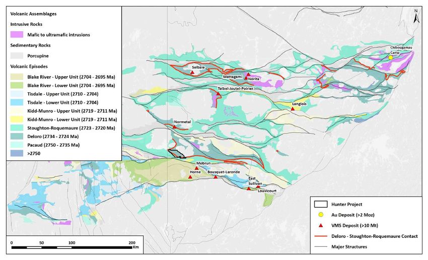
Hunter Drilling
                  •        169 DDH holes on property
                           (26,519m)

                              –       48 DDH holes part of
                                      Colonisation program (3,763m)

                              –       30 DDH holes directly on strike
   ONTARIO

                                      of Hunter Mine (8,179m)
   QUEBEC

                              –       Only 31 DDH holes testing the
                                      remainder of the felsic
                                      volcanics package (6,400m)

                  •        The Hunter Project remains largely
                           untested by drilling

                  * The Colonisation program was a Quebec government initiative in the 1960’s
                  where the government would pay to drill water wells for rural residents. As part of
                  this program, bedrock geology was logged and entered into the SIGEOM drill hole
                  database. Kenorland regards these holes as a separate dataset from normal
                  diamond drill holes because Colonisation holes were not drilled to test a specific
                  geologic target and were drilled in an area that was suitable for a water well

                                                                                                 10
Hunter Mineral Occurrences & Au in tills (HMC)
Mineralized/Altered zone Ice direction
• Mineral occurrences have been
• Up to 40m wide carb-sil-ser-chl alteration zones found within the Hunter project area
• 1 – 10m zones up to 30% py +/- cpy-sph-mt in
stringers and disseminated by previous explorers
• Hosted in rhyolitic flows, breccias, and lapilli tuffs
Cu-Ag-Au showing
• Grab sample of 3% Cu; 22 g/t Au
• 1.5% Cu; 6.7 g/t Ag over 0.3m • Occurrences typically located in
• Hosted in massive sulphide bed
within felsic tuffs windows of bedrock exposure that
Cu-Mo porphyry showing
penetrate glacial sediments
• Up to 0.6% Cu / 0.17m; 0.14% Mo / 0.48m
• Epidote-hematite alteration in QFP
Hunter Mine
Au-Ag-Cu-Mo showing • Prod. 0.17 Mt @ 1% Cu in 1957 • The occurrences that have been
• Stockwork/disseminate Cu-Ag-Au
• 4.8 g/t Au; 11 g/t Ag; 0.49% Cu over
0.15m within 100m zone of low-grade Ag
system hosted in felsic volcanics found to date are hosted within felsic
• Silica-epidote-chlorite alteration
• Mo samples up to 200ppm volcanics and have a metal signature
• Hosted in dacite breccia, within one small
interval of iron formation typical of intrusion-related Au
deposits or Au-rich VMS deposits
Cu-Ag-Au showing (Au-Ag-Cu; similar to Horne,
• Grab samples of 23.7 g/t Ag; 1.1 g/t Au &
0.77% Cu; 6.9 g/t Ag
LaRonde, Bousquet, Eskay Creek,
• Hosted in rhyolite breccia, locally pyrite
composed 10-20% of interfragment material
etc.)
• Rhyolite fragments are strongly chloritized
Cu-Ag-Au showing
• 100 g/t Au; 73 g/t Ag; 1.4% Cu over 0.45m
• Hosted in py-cpy stringer veins within
sericite altered rhyolite
11Hunter HMC Drill-for-Till compilation
Au – HMC Assay Cu – HMC Assay
• Au is highly anomalous in all sample media
Ice direction from historic drill-for-till sampling completed in
the 1980’s
• HMC Assays
– 4000 ppb Au is the 98th percentile for till
samples in the Abitibi (from Kenorland’s
database of ~40,000 samples)
– Majority of historic RC till sampling
holes have at least 1 samples >4000 ppb
Au
– Large clusters of >98th percentile Au
values
– Cu in HMC assays is much higher in the
felsic volcanics of the Hunter property
than to the south in mafic volcanics – Cu
must be due to mineralization and not
due to lithology
Au – Gold Grain Counts Au – Fine Fraction Geochemistry
• Gold Grain Counts
– Higher gold grain counts on the Hunter
property than around the Duparquet
deposit (5 Moz Au) to the south
• Fine Fraction Geochemistry
– Where fine fraction geochemistry
samples were collected, many holes
have samples >50 ppb Au
– Au in fine-fraction till samples is
spatially extensive and could be the
signature of a large Au-in-till dispersion
plume
*Readers are cautioned that results or information from an adjacent property does not infer or indicate similar results or information will or does occur on the Healy property. Historical
information from the subject or adjacent property cannot not be relied upon as the Company’s Qualified Person has not prepared nor verified the historical information.
12Hunter Comparisons Au in HMC till samples
Ice direction • Au in HMC assays at Hunter are
comparable to other major gold
Ice direction
deposits in the Superior province
• The Casa Berardi and Rainy River
gold deposits were identified using
drill-for-till methodology
Rainy River
Duparquet ~5 Moz Au @ 1.0 g/t
~5 Moz Au @ 1.5 g/t
• All of these gold deposits have
Ice direction
clusters of >98th percentile values for
Au in HMC assays (>4000 ppb)
Ice direction
Casa Berardi
~6 Moz Au @ 6.5 g/t Windfall
~5 Moz Au @ 8.6 g/t
*Readers are cautioned that results or information from an adjacent property does not infer or indicate similar results or information will or does occur on the Healy property. Historical
information from the subject or adjacent property cannot not be relied upon as the Company’s Qualified Person has not prepared nor verified the historical information.
13Hunter Comparisons Au in fine-fraction (-63um) till samples
• Au in fine fraction geochemistry is
comparable to major deposits such
Ice direction Ice direction
as Troilus, Eleonore, and Kenorland’s
Regnault prospect
• All of these deposits/prospects have
clusters of >50 ppb Au in -63um fine
Troilus fraction geochemistry samples
Duparquet ~7 Moz Au @ 1.5 g/t
~5 Moz Au @ 1.5 g/t
Ice direction Ice direction
• Very little sampling for fine fraction
geochemistry has been completed on
Eleonore
the Hunter property, however where
~7 Moz Au @ 7 g/t this type of sample was collected the
results are excellent and warrant
follow up
Regnault (Kenorland discovery)
Initial drilling up to 29m @ 8.5 g/t Au
*Readers are cautioned that results or information from an adjacent property does not infer or indicate similar results or information will or does occur on the Healy property. Historical
information from the subject or adjacent property cannot not be relied upon as the Company’s Qualified Person has not prepared nor verified the historical information.
14Hunter Surficial Geology
• Majority of the property is covered in
glaciolacustrine clay that inhibits all
surface geochemical exploration for
gold
ONTARIO
QUEBEC
• Average overburden thickness – 18m
• This is an advantage – if there was an
outcropping major deposit in the
area it would have been found
decades ago
• Additionally, no modern airborne EM
surveys have been carried out over
the property
• Proposed initial exploration includes
property-wide VTEM survey and
sonic drill-for-till sampling
15You can also read