Forests 2020 Sustainability and Resilience - Ecometrica Sarah Middlemiss Space Programme Manager
←
→
Page content transcription
If your browser does not render page correctly, please read the page content below
Forests 2020
Sustainability and Resilience
Ecometrica
Sarah Middlemiss                  Andy Shaw
Space Programme Manager           Consultant
sarah.middlemiss@ecometrica.com   andy@terreflexion.com
Forests 2020
● A £14.2 million investment by UK Space Agency IPP Programme to
  advance forest monitoring capabilities in 6 countries

● UK investment matched by partners

● Broad definition of forest monitoring systems, priorities set by partners

● UK experts (Universities of Edinburgh, Leicester, Carbomap,
  Ecometrica)
Forests 2020 Approach
    New methods of Change                         Mapping Risks and
         Detection                                 Opportunities

                                 Testing in           Improved map
                               Window Areas             products

    Information to national,                  Scaling-up and Production
    regional and local users                  using Digital Infrastructure
Information Sharing Infrastructure
Forests 2020 Timeline

        December                                                        January                            March
                                      September
          2016                                                           2019                              2020
                                        2017

        Inception                   Testing Phase             Scale up & Implementation             Sustainable Adoption

Defining priorities, window     Developing and testing        Roll out improved mapping        Project end; products, tools and
   areas, identify target     improved products in agreed   products and tools to end users,     methods are embedded in
stakeholders for improved           “window areas”              and continue improving         national / institutional systems
    mapping products                                           methods in window areas                and used in anger
Pathways to adoption: Sustainability Models
1) Embedding open source innovations in national systems
  We are working with government and research partners to ensure that Forests 2020
  innovations are embedded into national and state forest monitoring systems so that
  they continue to have impact after the project through capacity building programmes

    PYEO S2 processing &
    Machine Learning

    Restoration Potential
    Mapping and Fire Risk

    Hectares Indicator
Pathways to adoption: Sustainability Models
2)       Digital Infrastructure: EO Lab network
         Establishing proprietary digital infrastructure, the EO Lab, in key institutions to support
         curation and dissemination of new data products to end users

EO Lab Key features:
     ●    Performance and stability                    ●   Ability to handle complex, large, time-
     ●    Superior interface for non GIS experts           series datasets
     ●    Streamlined ingestion of EO data             ●   Built-in permissions system
     ●    Powerful querying capability                 ●   Support by people who understand the
     ●    Superior version control                         data and information being presented
                                                       ●   Competitive, transparent pricing
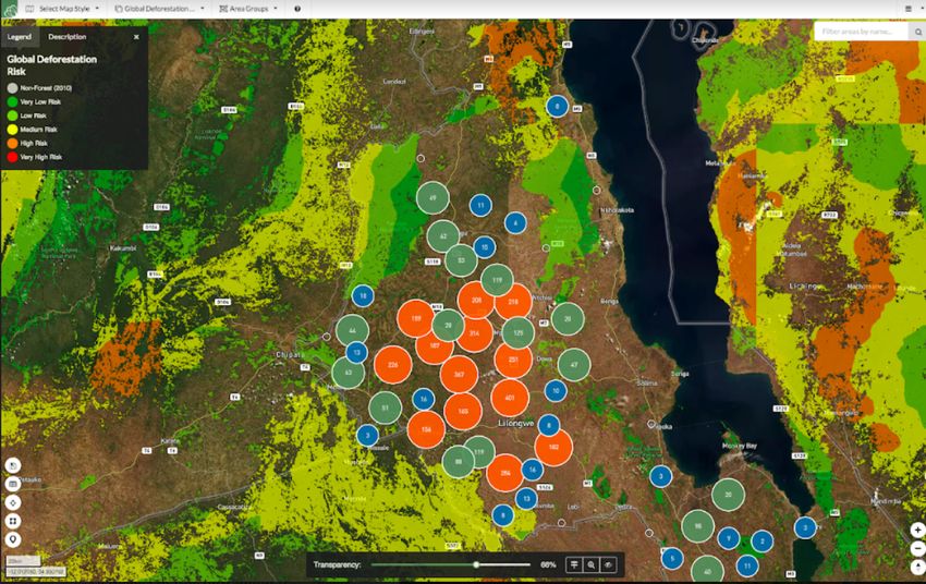
Pathways to adoption: Sustainability Models
3)   Commercial forest monitoring services: zero deforestation commodities

 ● Low marginal cost, scalable information infrastructure
 ● Aggregate 100’s or 1000’s of suppliers within region, country or world
 ● Collaborate with national agencies to support high quality mapping
 ● Use nationally approved, region-specific basemaps and definitions
 ● Semi-automated processing with expert checks
 ● Triangulation of EO data with geographical, social and economic risk factors
   to provide an holistic picture of deforestation and the risk of forest loss and
   degradation within and around the portfolio

F2020: Key Highlights to date
El Colegio de la Frontera Sur (ECOSUR), a research institute that is based in South Mexico, have
committed to maintaining an EO Lab license beyond 2020. By developing useful forest monitoring
applications for the South of Mexico, state level government organisations and municipalities can use
these outputs to plan and evaluate the impact of public policies in the region on the forests.

                                                             “Our EO lab applications have had more than
                                                             1,000 views, which is the second highest globally
                                                             after the UK. In 2018 we renewed our ECOSUR
                                                             EO lab license as we see the value of the platform
                                                             for disseminating geographical information in the
                                                             state to municipalities, government agencies,
                                                             academic institutions and NGOs for decision-
                                                             making.”

                                                             -Dr. Miguel Castillo, head of the Geographical and
                                                             Statistical Information Laboratory of ECOSUR.
F2020: Key Highlights to date
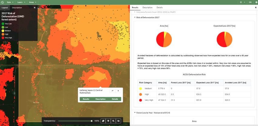
A key requirement for the Ministry of Environment and Forestry (MoEF) in Indonesia was to move from a manual to (semi-)
automated processing for land cover and forest cover mapping. IPB University have been working with University of
Leicester to develop new processing chains for Landsat and Sentinel 2 imagery.
Methods co-developed by IPB are then transferred to the National Institute of Aeronautics and Space (LAPAN), who have
the legal mandate to provide data to MoEF. MoEF then produce official land cover and land use change maps, with
improved methods that have been transferred via capacity building in F2020.
Once tested, new processing chains and LAPAN processes Landsat and S2 MoEF performs classification and
algorithms are transferred from IPB to LAPAN and provides data to MoEF disseminated national datasets by
official channelsF2020: Key Highlights to date
Public-private partnerships to support zero-deforestation
commodities
In Ghana, F2020 has been supporting local partners KNUST and
the Forestry Commission to develop mapping of the cocoa
growing region - traditionally challenging due to the shade loving
Cocoa
nature of the crop. Timings is crucial as the cocoa industry and Ecometrica
Companies
Government of Ghana have signed up to the Cocoa and Forests
Initiative (CFI).
The Ghana Forestry Commission is using the EO Lab platform to
disseminate official, national data sets that can be used by
National
multiple stakeholders. Ecometrica is supplying the cocoa industry
Mapping
additional monitoring services on a per farm basis, and using the
Agency
revenue to write off the costs of the platform license to the
Forestry Commission, and feeding revenue back to them to
cover national mapping efforts.F2020 & GFOI A number of methods and processed as part of F2020 can be shared as best practice among GFOI community: - EO Lab - Hectares Indicator - UoL PYEO Sentinel 2 processing - UoE Degradation Mapping - Lessons learned: Open source vs Commercial services
Beyond 2020: A Resilience Constellation
A >£300m, 10 year (2020-2030) collaboration between >6 countries to build
an EO constellation, data infrastructure and downstream applications to
support climate change resilience.

 ●   Building on established, international collaborations through programmes like
     IPP
 ●   Leveraging and strengthening UK’s New Space economy - agile development of
     small satellites servicing specific applications
 ●   Complementing existing programmes and assets, both publicly funded (e.g.
     ESA Copernicus) and commercial offerings (e.g. Planet, Earth-i)
 ●   Co-funding model - UK, International partners and private investment
Outputs The information products arising from the programme will be used for a range of climate change resilience, environmental MRV and natural resource management decision making. • GHG reporting for LULUCF and REDD+ • Flood and drought monitoring and risk assessments • Managing impacts of extractive industries • Monitoring sensitive and important ecological areas (coasts, wetlands, peatlands) • Early warning and near real time monitoring of wildfires
Overview of Mission and Service Concepts
Each information service will draw on a combination of Resilience Constellation missions,
plus existing or planned external sources.

       Resilience Missions                                    Services
                                                              •   Wildfire
         •   L-band SAR                                       •   Forest Degradation
         •   Nightlights                                      •   Infrastructure at risk monitoring
         •   K-line optical                                   •   Riverine flooding
         •   Multispectral optical                            •   Coastal flooding
         •   LiDAR aerial                                     •   Urban resilience and recovery
                                                              •   Crop health
                                                              •   Agricultural change
                                                              •   Economic indicators
                                                              •   Post-conflict recovery
                                                              •   GHG accounting
Data Policy
National Partners Commercial Partners Public
National Space Agencies and Private Investors in the RC Free data products for science
Government Institutions and general interest
National Services Commercial Services Public
• Access to all data and • Access to all data and • Deferred access to selected data
information products for use information products for and information products for any
within national programmes, further development and purpose
policies and agencies commercialisation to private
sector within partner countries
and worldwideBenefits for Partner Countries
Partners will tailor participation to match national priorities and ambitions. The collaboration will
enable partners to achieve greater scale, velocity of development and learning.
Resilience Services Technology Capability
Development and improvement of Courses, internships and partnerships
information services designed to meet national needs
Scale
Adaptation / Resilience Space Technologies
• Adapting agriculture and food • Design and planning of EO missions
systems • Sensor technologies
• Urban planning and infrastructure • Satellite design and manufacture
• Forests and wildlife • Data management
• Disaster response and recovery
Velocity Learning
Mitigation Space Applications
• GHG monitoring and reporting • Needs assessment and design
• Policy analysis • Data managementResilience Constellation Timeline
Phase 1 : Planning Phase 2: R&D + Test Phase 3: Build & Phase 4: Build &
(June ’19 - Mar ’20) Iteration Launch (1st Gen) Launch
(Apr ’20 - Mar ’21) (Apr ’21 - Mar ’26) (Apr ’26 - Mar ’30)
● Collating user ● Transfer working ● First iteration of ● Second iteration of
requirements and UK digital infrastructure manufacture, launch manufacture, launch
contribution from existing F2020 and operations and operations
● Develop Proposal projects ● Service enrichment ● Service enrichment
● Agree initial R&D ● Setup of information with RC mission data with RC mission data
funding services based on ● User-led agile ● User-led agile
existing data improvement to data improvement to data
● Individual component services services
testing
● System testingYou can also read