GDWG Meeting-20-10-2020 - India Meteorological Department Report Dr R.K. GIRI

Page created by Jose Weber
 
CONTINUE READING
GDWG Meeting-20-10-2020 - India Meteorological Department Report Dr R.K. GIRI
GDWG Meeting-20-10-2020

  India Meteorological Department Report
                Dr R.K. GIRI
GDWG Meeting-20-10-2020 - India Meteorological Department Report Dr R.K. GIRI
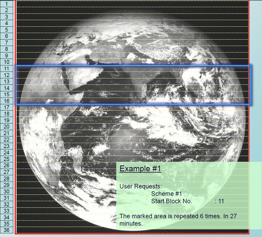
Current Indian Geostationary Meteorological Satellites

                                      74o
                                            82o

                                                  INSAT-3D:2013
                 INSAT-3DR:
                 8th September 2016
GDWG Meeting-20-10-2020 - India Meteorological Department Report Dr R.K. GIRI
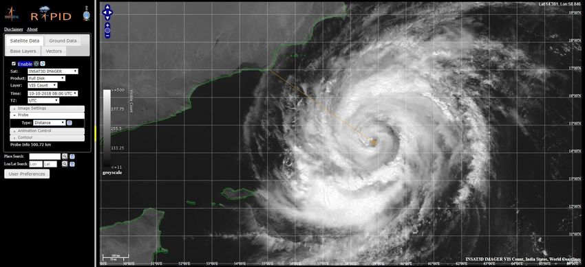
INSAT-3D/3DR-INDIA’s                       Advanced Weather Satellite

Mission objectives:
•To monitor earth’s surface, carryout oceanic
observations and its environment in various
spectral channels of meteorological importance.
•To provide the vertical profile of temperature and
humidity parameters of the atmosphere.
•To provide the data collection and data
dissemination capabilities from the Data Collection
platforms (DCPs).
•To provide the satellite aided search and rescue
services.
Payloads
• Six channel imager
• Nineteen channel sounder
• Data Relay Transponder(DRT)
• Satellite aided Search and Rescue(S&SR)
   System.

     Meteorological payloads are state-of-art and have significant technological improvement
     in sensor capabilities and higher resolution compared to earlier INSAT missions
GDWG Meeting-20-10-2020 - India Meteorological Department Report Dr R.K. GIRI
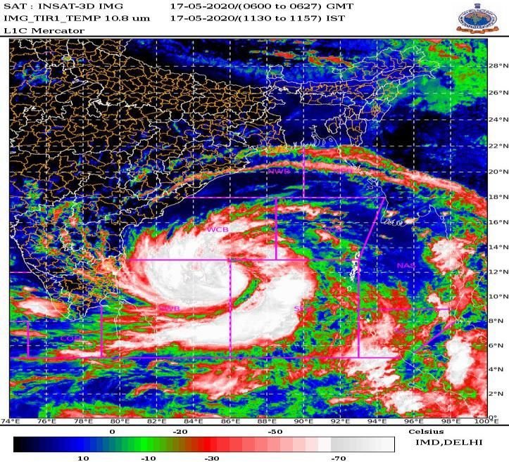
INSAT-3D/3DR-Imager
It is multi-spectral (optical radiometer) capable of generating
the images of the earth in six wavelength bands significant
for meteorological observations, namely, visible, shortwave
infrared, middle infrared, water vapor and two bands in
thermal infrared regions. The Imager generates images
of the earth disk from geostationary altitude of
36,000 km every 26 minutes and provide information
on various parameters, namely, outgoing long-wave
radiation, quantitative precipitation estimation, sea
surface temperature, snow cover, cloud motion
winds, etc

The Imaging System of INSAT-3D has the following significant improvements
over that of KALPANA and INSAT-3A:
 .
•Improved 1 km resolution in the visible band for the monitoring of mesoscale
phenomena and severe local storms
•Imaging in Middle Infrared band to provide night time pictures of low clouds
and fog.
•Imaging in two Thermal Infrared bands for estimation of Sea Surface
Temperature (SST) with better accuracy.
•Higher Spatial Resolution in the Thermal Infrared band.
GDWG Meeting-20-10-2020 - India Meteorological Department Report Dr R.K. GIRI
INSAT-3D Imager Channel Specification and
               their uses
Channels   Channel   Channel name           Spectral range   Resolution   Purpose
Number     ID                               (μm )            (Km)
1.         VIS       visible                0.55 – 0.75      1.0          Clouds, Surface
                                                                          features
2.         SWIR      short wave infrared    1.55 – 1.70      1.0          Snow, Ice and
                                                                          water phase in
                                                                          clouds
3.         MIR       medium wave infrared   3.7 – 3.9        4.0          Clouds, Fog, Fire
4.         WV        water vapour           6.5 – 7.1        8.0          Upper-Troposphere
                                                                          Moisture
5.         TIR1      long wave infrared     10.3 – 11.3      4.0          Cloud top and
                                                                          surface
                                                                          temperature
6.         TIR2      split                  11.5 - 12.5      4.0          Lower-Troposphere
                                                                          Moisture
GDWG Meeting-20-10-2020 - India Meteorological Department Report Dr R.K. GIRI
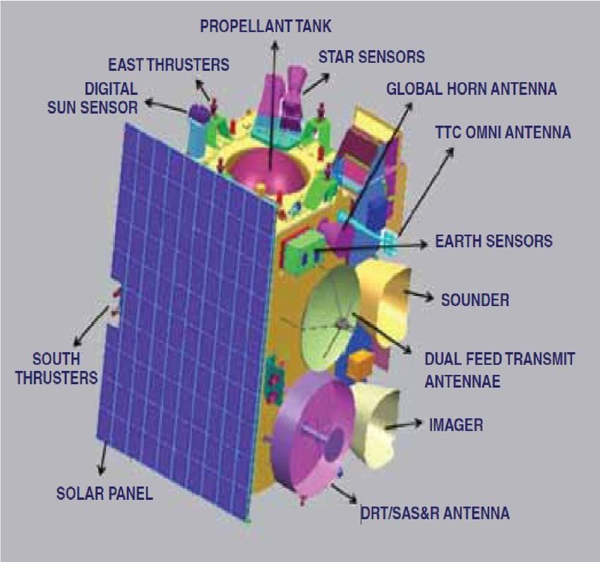
INSAT-3DR-Sounder
INSAT-3D carries a newly developed 19 channel sounder, which
is the first such payload to be flown on an ISRO satellite mission.
The Sounder has eighteen narrow spectral channels in shortwave
infrared, middle infrared and long wave infrared regions and one
channel in the visible region. The ground resolution at nadir is
nominally 10x10km for all nineteen channels. Atmospheric
Sounding System, provide vertical profiles of temperature 40 levels
(surface to 70 km), Humidity 21 levels (surface to 15 km) and integrated
ozone from surface to top of the atmosphere These profiles are available
for a selected region over Indian landmass every one hour and for the
entire Indian Ocean Region every sixth hours

The salient features of INSAT-3D sounder design are as follows:
1. Blackbody calibration sequence is modified as compared to VHRR of earlier satellites.
2. In order to improve noise performance, facility to collect two or four samples (0.2 sec or 0.4
   sec step & dwell time) of the same area also which can then be processed on ground. This
   will increase the sounding time proportionally.
3. A biannual rotation of yaw by 180 degree has been introduced to reduce the cooler patch
   temperature. This is to be taken care during processing.
GDWG Meeting-20-10-2020 - India Meteorological Department Report Dr R.K. GIRI
INSAT-3DR Sounder Channels Characteristics
                           lc             nc      NET        Principal
Detector     Ch. No.                                                                Purpose
                          (mm)          (cm-1)    @300K     absorbing gas

               1             14.67       682     0.17           CO2         Stratosphere temperature
               2             14.32       699     0.16           CO2         Tropopause temperature
               3             14.04       712     0.15           CO2         Upper-level temperature
Long wave      4             13.64       733     0.12           CO2          Mid-level temperature
               5             13.32       751     0.12           CO2          Low-level temperature
               6             12.62       793     0.07        water vapor    Total precipitable water
               7             11.99       834     0.05        water vapor    Surface temp., moisture
               8             11.04       906     0.05         window          Surface temperature
               9                 9.72   1029     0.10          ozone              Total ozone
Mid wave       10                7.44   1344     0.05        water vapor      Low-level moisture
               11                7.03   1422     0.05        water vapor       Mid-level moisture
               12                6.53   1531     0.10        water vapor      Upper-level moisture
               13                4.58   2184     0.05           N2O          Low-level temperature
               14                4.53   2209     0.05           N2O          Mid-level temperature
               15                4.46   2241     0.05           CO2         Upper-level temperature
Short wave
               16                4.13   2420     0.05           CO2          Boundary-level temp.
               17                3.98   2510     0.05         window          Surface temperature
               18                3.76   2658     0.05         window        Surface temp., moisture
 Visible       19            0.695      14367           -      visible               Cloud
GDWG Meeting-20-10-2020 - India Meteorological Department Report Dr R.K. GIRI
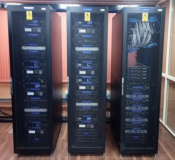
OPERATIONAL SCENARIO OF INSAT-3DR SOUNDER
Time (UTC)   INSAT 3DR
GDWG Meeting-20-10-2020 - India Meteorological Department Report Dr R.K. GIRI
Geophysical parameters/products of INSAT-3D/3DR Imager

                                                     INS                      1.QPE
                                SST         LST             UTH               2. IMR
                      OLR                                                     3. HE
1.VIS/MIR winds                                               Rain Estimate
2. WV winds
3. CMV
4.LL winds          AMV
5. HL winds                                                           CTBT

                  Cloud mask

                                                                  CTT & CTP

                     Smoke
                                                             Clear sky-BT
                         Fire         AOD     Snow    Fog
GDWG Meeting-20-10-2020 - India Meteorological Department Report Dr R.K. GIRI
Geophysical parameters/products of INSAT-3D/3DR Imager
             Product                  Temporal Resolution         Horizontal        Format            Domain       Unit
                                                                  Resolution
Upper Tropospheric Humidity (UTH)   Half hourly, Daily, Weekly,    Per pixel       HDF/JPEG       Globe coverage          Percentage (%)
                                            Monthly
 Total Precipitable Water Vapour           Half hourly             Per Pixel       HDF/JPEG        Globe (Ocean)                cm
          (New Product)
  Sea Surface temperature (SST)            Half Hourly            0.50x 0.50       HDF/JPEG        Globe (Ocean)          degree Celsius

  LST (Land Surface Temperature)           Half Hourly             Per pixel       HDF/JPEG        Globe (Land)               Kelvin

                                                                  Cloud Products

           Cloud Mask                      Half Hourly             Per pixel       HDF/JPEG            Globe       0- Pixel is clear,
                                                                                                                   1- pixel is cloudy,
                                                                                                                   2- pixel is probably clear
                                                                                                                   3- pixel is probably
                                                                                                                   cloudy
   CTT (Cloud top temperature)             Half Hourly              50 km          HDF/JPEG            Globe                   Kelvin

        Cloud top pressure                 Half Hourly              50 km          HDF/JPEG            Globe                   hPa

     Effective cloud emissivity            Half hourly              50 km          HDF/JPEG            Globe              percentage (%).

          Cloud Fraction                   Half Hourly              50 km          HDF/JPEG            Globe       Expressed in fractions

  Cloud Particle Effective Radius          Half hourly             Per Pixel       HDF/JPEG   300E- 1300E                    Microns
                                                                                              500S- 500N

     Cloud Optical Thickness               Half hourly             Per Pixel       HDF/JPEG   300E- 1300E                 percentage (%).
                                                                                              500S- 500N
Geophysical parameters/products of INSAT-3D/3DR Imager
                                                                          Rain Fall products (Quantitative Precipitation Estimation)
 Hydro Estimator Precipitation (HEM)             Half hourly, Daily, Weekly, Monthly           Per pixel                  HDF/JPEG                               Globe   mm/hr (mm-Daily, Weekly,
                                                                                                                                                                                Monthly)
  Insat Multispectral Rainfall (IMSRA)           Half hourly, Daily, Weekly, Monthly                      0.10x 0.10                   HDF/JPEG     300E- 1200E          mm/hr (mm-Daily, Weekly,
                                                                                                                                                    400S- 400N                  Monthly)
    Global precipitation Index (GPI)                 Three Hourly Accumulated                               1 0x 1 0                   HDF/JPEG     300E- 1200E                   mm
                                                                                                                                                    400S- 400N
             IMSRA (Improved)                    Half hourly, Daily, Weekly, Monthly                      Per Pixel                    HDF/JPEG                Globe     mm/hr (mm-Daily, Weekly,
                                                                                                                                                                                Monthly)
                                                                                   Atmospheric Motion Vectors (AMV) and wind Derived products
    Cloud Motion Vector (CMV/IR1-wind)                   Half Hourly at Levels (                            Point                       Gif/JPEG   300E- 1300E                    Knots
                                                              100-400mb                                                                            400S- 400N
                                                               401-700mb
                                                              701-975mb)

        Water vapour Winds (WVW)                         Half Hourly at Levels (                            Point                       Gif/JPEG   300E- 1300E                    Knots
                                                               100-250mb                                                                           400S- 400N
                                                               251-350mb
                                                              351-500mb)

Visible (during day) /MIR (during night) Winds      Half Hourly at levels (600-800mb                        Point                       Gif/JPEG   300E- 1300E                    Knots
                                                              801-975mb)                                                                           400S- 400N

            IRW –Merged winds                                 Half hourly                                   Point                       Gif/JPEG   300E- 1300E                    Knots
                                                                                                                                                   400S- 400N
            WVW-Merged winds                                  Half hourly                                   Point                       Gif/JPEG   300E- 1300E                    Knots
                                                                                                                                                   400S- 400N
                Vis-HR winds                                  Half hourly                                   Point                       Gif/JPEG   300E- 1300E                    Knots
                                                                                                                                                   400S- 400N
      Vorticity (850,700,500 & 200 hPa)                       Half hourly                    0.50 X0.50                                 Gif/JPEG   300E- 1300E                   10-5 x /sec
                                                                                                                                                   400S- 400N

   Low Level Convergence (850-925 hPa):                       Half hourly                                 0.50 X0.50                    Gif/JPEG   300E- 1300E                   10-5 x /sec
                                                                                                                                                   400S- 400N

   Upper level Divergence (150-300 hPa):                      Half hourly                                 0.50 X0.50                    Gif/JPEG   300E- 1300E                   10-5 x /sec
                                                                                                                                                   400S- 400N

                Wind Shear:                                   Half hourly                                 0.50 X0.50                    Gif/JPEG   300E- 1300E                    Knots
                                                                                                                                                   400S- 400N
            Mid-Level wind Shear                              Half hourly                                 0.50 X0.50                    Gif/JPEG   300E- 1300E                    Knots
Geophysical parameters/products of INSAT-3D/3DR Imager Miscellaneous Geophysical Products
           Snow cover                             0500,0530,                                Per pixel                   HDF/JPEG   200E- 1100E                                    Unit-less
                                                0600,0630 UTC                                                                      500S- 500N

               Fire                              Half Hourly                                  Point                     HDF/JPEG   600E- 1000E                                    Unit-less
                                                                                                                                   00N- 400N
              Smoke                              Half Hourly                                  Point                     HDF/JPEG   600E- 1000E                  Unit-less
                                                                                                                                   00N- 400N
    Fog (Night Time/Day Time)                    Half Hourly                                Per pixel                   HDF/JPEG   450E- 1100E                                    Unit-less
                                                                                                                                   100S- 450N
           Fog Intensity                         Half Hourly                                Per pixel                   HDF/JPEG   450E- 1100E                  Unit-less (1,2,3,4)
                                                                                                                                   100S- 450N
   Aerosol Optical Depth (AOD)       0500 to 0830 UTC on half hourly basis   Per pixel for clear sky                    HDF/JPEG   450E- 1000E                                    Unit-less
                                                                                                                                                   100S- 450N

                                                                                 Radiation Products/ Agromet Products

Outgoing Long Wave Radiation (OLR)    Half hourly, Daily, Weekly, Monthly                   Per pixel                   HDF/JPEG   Globe                                          Watt/m2

          Net Radiation                           Half hourly                               Per Pixel                   HDF/JPEG   600E- 1000E                                    Watt/m2
                                                                                                                                   50N- 400N

       Land surface Albedo                        Half hourly                               Per Pixel                   HDF/JPEG   600E- 1000E                                   Unit -less
                                                                                                                                   50N- 400N
                                                                                                                                                     (land)
      Short Wave Radiation                        Half hourly                               Per Pixel                   HDF/JPEG   400E-   1100E                                  Watt/m2
                                                                                                                                   150S- 250N
                                                                                                                                                    (Ocean)
        Evapotranspiration                        Half hourly                               Per Pixel                   HDF/JPEG   500E-   1050E                                      mm
              (PET)                                                                                                                50S- 410N
                                                                                                                                                     (land)
    Actual Evapotranspiration                     Half hourly                               Per Pixel                   HDF/JPEG   600E- 1000E                                    mm/day
                                                                                                                                   50N- 400N
            Insolation                           Half Hourly                                Per pixel                   HDF/JPEG   450E- 1100E                                    Watt/m2
                                                                                                                                   100S- 450N
Geophysical parameters OF INSAT-3DR Sounder

                     Temperature
                       profile
                                                 Geo
          Total                                potential
          ozone                              height Profile
    Dry
 microburst                                          Humidity
   index                                              profile
         Lifted                            Maximum vertical
                                               theta –e
         Index                               differential
                   Layer & perceptible
                  water index (1000-900,
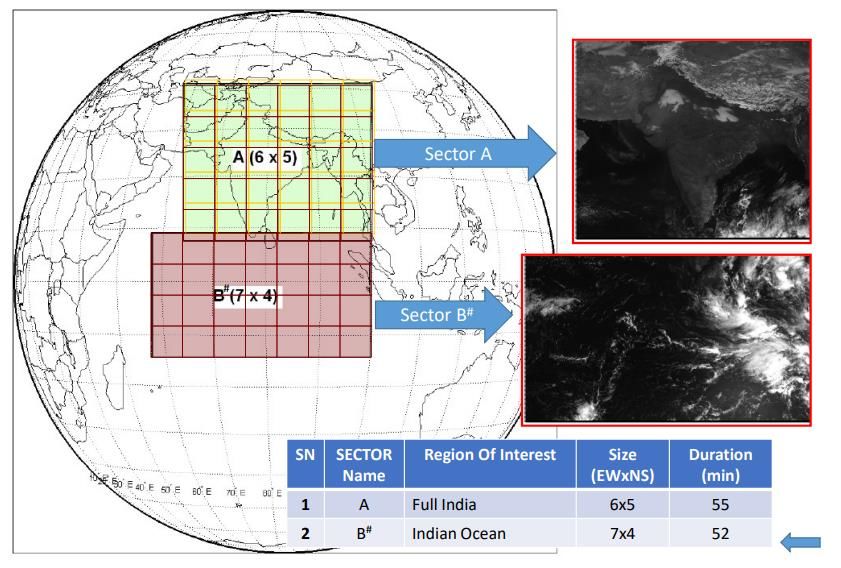
                  900-700, 700-300hpa)
SOP of Rapid Scan Strategy of Imager of INSAT-3DR has been finalised for
            conducting during Cyclone/ specific extreme weather event. During the period
            from June 2019 to May 2020, Rapid Scan has been successfully carried out for
            four cyclones i.e. SuCS Kyarr, ESCS Maha, VSCS Bulbul and VSCS Pawan.

Normal mode scan area has been divided into 36 blocks
 in North-South directions such that:
    Each block covers 0.50 in N-S direction.
    No of Scan lines for Each block: 40
    Time required to scan each block: 45 seconds

   Extent of coverage: 6 Blocks (3° coverage in 234 lines)
   No. of repetitions: 6
   Time required: 27 minutes
   (6 blocks with 6 repetitions)
RAPID Scan conducted during June 2019 to May 2020

                                                        SuCS KYARR     ESCS Maha

                                SuCS AMPHAN

Cyclone &     Duration                       Number
Intensity                                    of Scans

SuCS Kyarr    27th October- 02nd             4320
              November 2019

ESCS Maha     30th October-07th November
              2019
                                                        VSCS BULBUL   VSCS PAWAN
VSCS Bulbul   05th   -11th   November 2019

VSCS Pawan    04th-08th December 2019        1140

SuCS Amphan   15th -21st May 2020            1560
RAPID(Real time Analysis of Products & Information Dissemination) :- It is a web based quick visualization and
 analysis tool for satellite data on a real time basis. This introduces Next Generation Weather Data Access &
                                              Advanced Visualization.
                                     http://www.rapid.imd.gov.in

             Connects atmospheric- and geosciences
             No specific OS/ software/ library / compiler required on
              the desktop. Acess through browserc
             Provides features of interest to scientific community
             Open standards OGC
                Web Mapping Service (WMS) – For visualization
                  Extensions written for scientific community
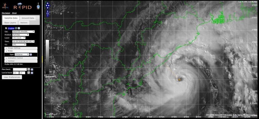
            Zero learning curve
Distance Probing of Eye Region for VSCS “LUBAN” and
VSCS “TITLI”
MULTI-MISSION METEOROLOGICAL DATA RECEIVING & PROCESSING SYSTEM (MMDRPS) FOR INSAT-3D,
INSAT-3DR AND INSAT-3DS SATELLITES AND SYSTEM IS ON AN OPERATIONAL BASIS SINCE 01ST OCTOBER 2019.

   The salient features of MMDRPS are:
   Image processing software for INSAT-3D/3DR and upcoming
   INSAT-3DS satellite data.
   • MMDRPS has a very high end processing system which cuts
      down the processing time from 15 minutes to 7 minutes.
   • Cal/ Val site data / GISCS calibration coefficient to be used in
      operational chain.
   • System is capable to process RAPID scan data of INSAT-3DR
      Imager payload conducted during Extreme weather events.
   • System has the capability to convert data into various
      standard data formats like ASCII, binary, NetCDF.
   • MMDRPS have storage capacity of the order of 2.0/2.0PB(
      Main/ Mirror) & 324TB SSD which will facilitate online sharing
      of processed data for all Indian meteorological satellites to the
      registered users as per IMD data policy.
   • All available past satellite datasets starting from 1983 will be
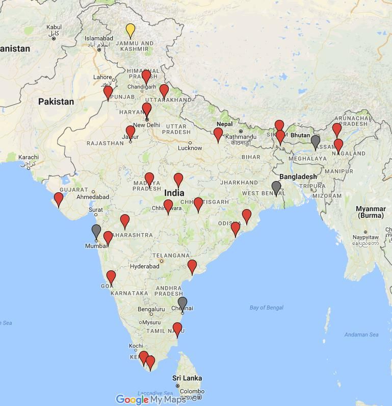
      kept in online mode in due course of time.
GNSS Network (25)

           Parameters:
           1. Surface- Temprature, Pressure, Humidity
           2. IPWV
           3. Zenith Total Delay
           4. Total Electron Content
Online Data Supply system in implementation phase and will be
launched shortly.
Data Supply system (DSS) is an online software package, currently in implementation phase and will be highly beneficial in
supplying INSAT-3D/3DR data to users over the internet. Data supply to the users as per IMD data policy guidelines.
Timeline of upcoming satellite
         operations.
                                                 Geo-Imaging
                                                  Satellites

                                                                                  3rd Qtr,2021
                                                                                  • Ocean Color &
                                                            2nd Qtr,2021            Wind Vector-
                                                            • INSAT 3DS (           Continuity + SST
                                                              Imager & Sounder)
                                           1st Qtr,2021
                                           • OCEANSAT-3A
                                                                                         Ocean
                            4th Qtr,2020        Ocean                                  application
                            • OCEANSAT-3      application                               satellites
                                               satellites
            4th Qtr, 2020
              • GISAT-1
             Observations
              from GEO)

                       Geo-Imaging
                        Satellites
You can also read