GIS to catalogue the shipment of naves - lapidariae in Mediterranean Sea - imeko
←
→
Page content transcription
If your browser does not render page correctly, please read the page content below
2019 IMEKO TC-4 International Conference on
Metrology for Archaeology and Cultural Heritage
Florence, Italy, December 4-6, 2019

            GIS to catalogue the shipment of naves
              lapidariae in Mediterranean Sea
                                                  Maurizio Delli Santi1
  1
      CNR – ISPC, Consiglio Nazionale delle Ricerche – Istituto di Scienze del Patrimonio Culturale,
                             Lecce, E-mail: maurizio.dellisanti@cnr.it;

Abstract – In this study we are going to list and                provisions source in imperial age were Greece (for
catalogue ancient marbles from the sea bottom along              ancient white marbles), Asia Minor, Egypt and Tunisia
the Mediterranean Coast and we discuss the                       (for coloured marbles and granites). For example from
localization and the morphological features of the               Greece Pario marble arrived (from Paros), Hymettus and
original quarries that are situated above all in Greece,         Pentelic (the quarries were near Athens), Cipollino or
Asia Minor, and in Egypt. Finally we are going to                Carystus Caristo (from Eubea). In Asia Minor, in Phrigia
expose the implementation of data in a GIS.                      in particular, Pavonazzetto was pulled out; in Tunisia
                                                                 instead there were the “giallo antico” (ancient yellow) or
                   I. INTRODUCTION                               Numidian marble. In conclusion, we have to remember
   In the imperial period, between the 2nd and the 3rd           that Egypt supplied the granite for roman Obelisks, the
century a.C., many rich buyers turned to famous oriental         red porphyry (for Emperors sarcophagi) and finally
shops for the order of some decorated sarcophagus,               alabasters. The increase of marble using created a statio
sculptures and precious marble reliefs.                          marmorum or marbles department that received and
   The most important centers were in Grece, in Attica, in       provided marbles. These marbles came from several
Asia Minor, at Afrodisia and at Efeso, where expert              empire and were employed for very different uses: the
artisans used to work under the supervision of imperial          building and the restoration of public monuments, to
officials, in factories near the quarries.                       adorn regal palaces and to be sold to privates. The
   The shipment was by naves lapidariae that took on             intensity and the importance of this type of commerce is
board columns, capitals, finished architectural                  also documented by a lot of documentary materials about
decorations, some of those were unfinished works or they         many shipwrecks of naves lapidariae (ships that carried
had just been rough-hewn, to be finished in the places,          out stones) along Mediterranean Coast places, in addition
where they were taken, by traveling workers or local             to Greek coast, like the coast of Calabria, Sicily and
stonecutter.                                                     Apulia (figures 1,2,3,4). The stones ships reached
   There are many wrecks with a stone shipment (naves            especially Ostia, where the shipment was placed on big
lapidariae) along sea coast of the Mediterranean Sea.            boats that sailed the Tiber up to Rome.
   In this study we are going to list and catalogue ancient
marbles from the sea bottom along the Mediterranean
Coast and we discuss the localization and the
morphological features of the original quarries that are
situated above all in Greece, Asia Minor, and in Egypt.
Finally we are going to expose the implementation of
data in a GIS.

 II. THE SHIPMENT OF NAVES LAPIDARIAE
  The use of marbles, already common in late republican
age, became more diffused in imperial age. At the
beginning of this trend, if we can define it in this way, the
use of imported ancient marbles was devoted to the
public buildings or to the rich senatorial villas in
particular. With the development of the Empire, the use
of marbles caught on more and more and marble became
important for funerary buildings. Even after the Luni
                                                                  Fig. 1 – Italy, San Pietro in Bevagna wreck (Apulia):
quarries (Carrara white marble) opening, the best
                                                                 Greek marble sarcophagi.

                                                                355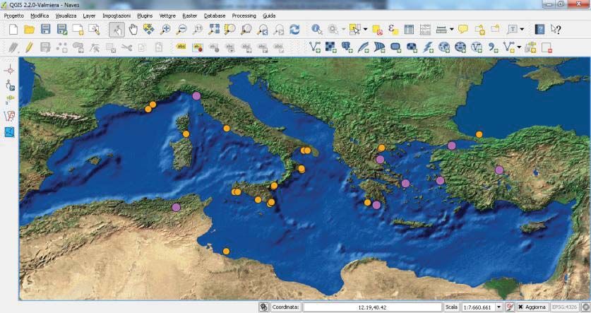
III. THE STRUCTURE OF GIS
                                                               The most interesting element of the data model in a
                                                            GIS is the database (Table 1). Generally cartography is
                                                            principally necessary to produce maps for the
                                                            representation of information; but a GIS has the data
                                                            analysis as main purpose, to become a support instrument
                                                            for decisions.
                                                               In a GIS analysis we do not get a simple geometric
                                                            representation of artifacts and objects: rather we point to
                                                            the direct relationships among different elements, like
                                                            connection, vicinity or inclusion.
                                                               By these relationships the GIS allows us - with a
                                                            structure of data that are different but complete – to
                                                            define complex monitoring analysis of the interested area,
                                                            with a definition of specific features of the topos.
                                                               Essentially, data model, in an interaction perspective,
                                                            establish the input of descriptive data of every single real
  Fig. 2 – Italy, Torre Chianca wreck (Apulia): n. 5        object, that we can define area attributes.
Cipollino (Karistos, Grecia) marble columns.                   This set of information (geometry, topology, attributes)
                                                            are then implemented in a GIS by a physical model, that
                                                            now is based on data structure of relational nature, that
                                                            are characteristic of more advanced database and on
                                                            hardware e software architectures that are in client/server
                                                            mode, in local nets of calculators: in our case, GIS
                                                            software that has been used for implementation is a QGIS
                                                            software.
                                                               Usually, the essential steps of creating a geographic
                                                            data elaboration are: data input, data management, data
                                                            analysis, data presentation.
                                                               However we need to distinguish data types; they can be
                                                            divided into two categories: spatial data (that is the
                                                            placement of geographic elements, in our case the
                                                            archaeological site along the Mediterranean Coasts) and
                                                            attributes data (in this case the classification of the site of
                                                            naves lapidariae wrecks, the name of ancient marbles,
                                                            marble quarries, the amount of marble, etc.), that are
  Fig. 3 – Italy, Naxos Gardens wreck (Sicily): marble      associated to spatial data (figure 5).
block on seabed (ph. by Tania Marchesini).                     The spatial data (maps, surveys, etc.) have been
                                                            implemented by manual digitalization, scanning and
                                                            graphic files in vectorial format; but the attributes data
                                                            have been input by script with a computer keyboard
                                                            (figures 6,7).

  Fig. 4 – Italy, Capo Taormina wreck (Sicily): columns
     at 24 meters depth (ph. by Tania Marchesini).

                                                      356
N.   PLACE               ARCHAEOLOGICAL             ANCIENT        DIMENSIONS
                         ARTIFACT                   MARBLE
1    Porto Nuovo         4 shaft sections;          Marmo          Diameter =1,5 m.
     (Corsica)           5 blocks                   Lunense        thickness = 1 m.;
                                                                   width 1,9 -2,5 m.
                                                                   lenght 1,9 -5,8 m.
2    Giardini Naxos      13 blocks                  Cipollino      1x3,3x0,6 m.
     (Sicily)            23 columns shafts                         0,4-0,8 m. diameter ,
                                                                   lenght 6 m.
3    Punta Scifo         6 monolitic basins         Pavonazzetto   2 width 1,02 m.
     (Calabria)                                                    1 width 1,7 m.
                                                                   1 width 2,10 m.
                                                                   2 width 2,37 m.
                                                                   5 fragments 2,10 m.
                                                                   4 basins 1,02 m.
                                                                   4 supports height 0,6 m.
                                                                   5 bases height 0,42 and width 1 m.
                                                                   2 sections height 4,74 m.
                                                                   3 sections height 5,85 m.
                                                                   1 shaft height 5,82 m.
                         2 blocks                   Proconnesio     Lenght 3,12 m.
                         1 blocks                   White Frigio   Lenght 3,12 m.

4    Capo Granitola 1    49 blocks                  Proconnesio    Lenght from 0,5 m. to 5 m.
     (Sicily)
5    Capo Granitola 2    3 corinthian capitals      White marble
     (Sicily)
6    Camarina            2 columns                  Ancient
     (Sicily)                                       Yellow
                                                    (Giallo
                                                    antico)
7    Capo Taormina       2 blocks                   Cipollino
     (Sicily)
8    Isola delle         6 Blocks                   Proconnesio    Height 0,55 m.
     Correnti (Sicily)   10 blocks                                 Height 0,70 m.
                         5 blocks                                  Height 0,80 m.
                         7 blocks                                  Height 0,95 m.
                         5 blocks                                  Height 1,20 m.
                         6 blocks                                  Height 1,40 m.
                         2 blocks                                  Height 1,75 m.
9    Marzamemi 1         3 blocks                   White gray     Height 0,50 m.
     (Sicily)            5 blocks                   marble         Height 1,00 m.
                         2 blocks                                  Height 1,30 m.
10   Marzamemi 2         Architectonic elements     Proconnesio
     (Sicily)            1 slab                     Ancient
                                                    green (Verde
                                                    antico)
11   Capo Cimiti         2 shafts                   Green          lenght 6 m., diameter 0,9 m.
     (Calabria)          4 shafts                   Cipollino      Lenght 8,5 m., diameter 0,9 m.

12   Torre Sgarrata      18 sarcophagus             Taso Marble
     (Apulia)
13   San Pietro in       23 sarcophagus             Marmo di
     Bevagna (Apulia)                               Taso
14   Ladispoli (Lazio)   Three lines of columns     Marble

                                                  357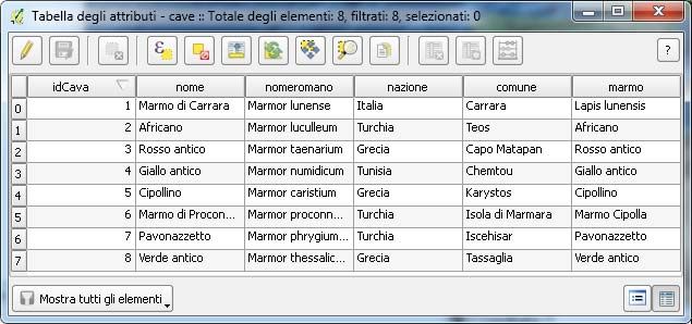
shafts
15   Dramont              3 blocks                        African         3,8 x 0,95 x 0,8 m.
     (France)                                             Marble          2,68 x 1,1 x 1,45 m.
                                                                          2,2 x 1 x 1 m.
16   Saint-Tropez         12 marble elements              Marmo
     (France)             (column drums, bases,           Lunense
                          lastre e architrave)
17   Isola di Sapientza   Slabs,                          White marble
     (Greece)             Columns                         Granite
18   Methone 1            4 sarcophagus                   Marble from
     (Greece)                                             Assos in
                                                          Troade
19   Methone 2            20 shafts                       Egyptian
     (Greece)                                             Granite
20   Sile                 shafts                          Ancient
      (Turkey)            1 block                         green (Verde
                          5 capitals                      antico)
                          1 column base
                          2 blocks                        Proconnesio
                          1 slab
                          1 statue                                        height 4,5 m.
                          1 feminine bust
                          1 Sarcophagus top
21   Sidi Ahmad port      2 columns                       Pentelico
     (Libya)              blocks

                                     Table 1. - The database fields of GIS.

                                            Fig. 5 – Attributes Tab.

                                                   358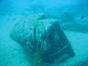
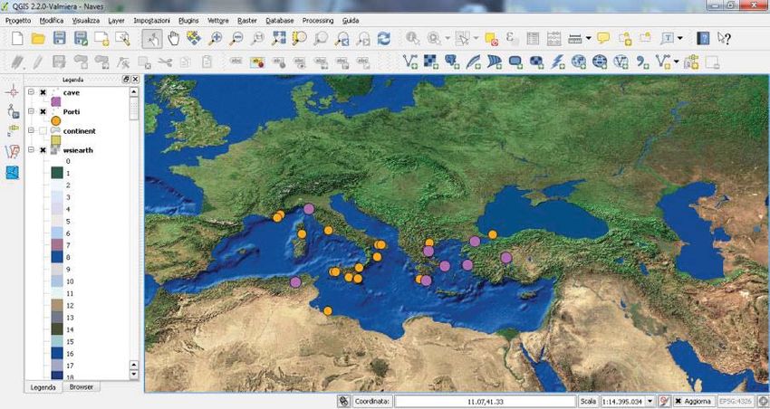
Fig. 6 – GIS, a work session screen: wrecks with yellow circles (archaeological site)
                                    and ancient marble quarries with purple circles.

                                            Fig. 7 – GIS, a work session screen.

                                                                 upgrading of a wider interested territory area.
                IV. CONCLUSIONS
  Analysis instrument, that is always updated and has
simplicity of reading and interpretation, is composed of                             REFERENCES
computer documents, that are pointed not only to the             [1] Borghini G. (a cura di) (1997), Marmi antichi,
scientific study, but also to every institutional request, to        Edizioni De Luca, Roma.
promote ventures for recovering, materially and                  [2] De Nuccio M. – Ungaro L. (a cura di) (2002), i
economically, the archaeological heritage that is along              marmi colorati della Roma imperiale, Marsilio
Mediterranean Coasts.                                                Editori, Venezia.
  Soon it stands out that the massive presence in the            [3] Delli Santi M. (2013), Geomatica e beni culturali:
ships' wrecks of proconneso marble, that is a white                  un GIS per la gestione e valorizzazione delle
marble with gray stripes from marmara isle in turkey,                masserie della Basilicata,      in Atti della 17°
which was loved a lot by romans marble workers,                      Conferenza Nazionale ASITA, Federazione Italiana
because of its low cost on market, as we can see on edict            delle Associazioni Scientifiche per le Informazioni
of maximum prices by Diocleziano.                                    Territoriali e Ambientali (Riva del Garda, 5 - 7
  Therefore this study contains development starting                 novembre 2013), 623 - 630.
points for a territorial improvement and the planning of a       [4] Delli Santi M. (2013), A survey of Franciscan
marble heritage recovering systematic program for an                 convent in Basilicata (Italy): creation of a gis for

                                                                359
knowledge, improvement and use of cultural
heritage, Proceedings of the 4th EARSel Workshop
on “Remote Sensing for Cultural Heritage” (6 – 7
June 2013 Matera, Italy), 55 – 62.
[5] Delli Santi M. (2014), La Geomatica per la
valorizzazione del patrimonio architettonico nella
provincia di Potenza, in Atti della 18° Conferenza
Nazionale ASITA, Federazione Italiana delle
Associazioni Scientifiche per le Informazioni
Territoriali e Ambientali (Firenze, 14 - 16 ottobre
2014), 461- 468.
[6] Delli Santi M. (2015), La Geomatica per il
monitoraggio del patrimonio architettonico della
provincia di Matera, in Atti della 19° Conferenza
Nazionale ASITA, Federazione Italiana delle
Associazioni Scientifiche per le Informazioni
Territoriali e Ambientali (Lecco, 29 - 30 settembre, 1
ottobre 2015), 355–362.
[7] Delli Santi M. (2016), Geomatica e beni culturali:
GIS per la valorizzazione degli insediamenti rupestri
dell’Alto Salento, in Atti della 20° Conferenza
Nazionale ASITA, Federazione Italiana delle
Associazioni Scientifiche per le Informazioni
Territoriali e Ambientali (Cagliari, 8 - 10 novembre
2016), 309-316.
[8] Maurizio Delli Santi, Cultural Heritage
management in GIS: cataloguing of ancient marbles
in Benevento (Southern Italy), Proceedings of the
1st International Conference on “Metrology for
Archaeology”, (Benevento, Italy – October 21 – 23,
2015), Volume I, pp. 223 – 226.
[9] Maurizio Delli Santi, Metrology and archaeology:
the Doric capitals of Oria (Apulia region, Southern
Italy), Proceedings of IMEKO International
Conference on Metrology for Archaeology and
Cultural Heritage, (Torino, Italy – October 19 – 21,
2016), IMEKO 2016, pp. 220 – 223.
[10] Maurizio Delli Santi, Gis for cataloging the ancient
marbles of Oria (Apulia region, Southern Italy),
Proceedings of IMEKO International Conference on
METROLOGY FOR ARCHAEOLOGY AND
CULTURAL HERITAGE (Castello Carlo V, Lecce,
Italy – October 23 – 25 2017), 2017, pp. 318 – 321.
360You can also read


