EO FOR WATER AND NATURAL RESOURCES MONITORING MAKING THE INVISIBLE VISIBLE - MIMOUNI Mustapha - Copernicus
←
→
Page content transcription
If your browser does not render page correctly, please read the page content below
EO FOR WATER AND NATURAL RESOURCES MONITORING
          MAKING THE INVISIBLE VISIBLE
      Copernicus Relays December Visio conference
                   17 December 2020

                 MIMOUNI Mustapha
                Sahara and Sahel Observatory
                mustapha.mimouni@oss.org.tn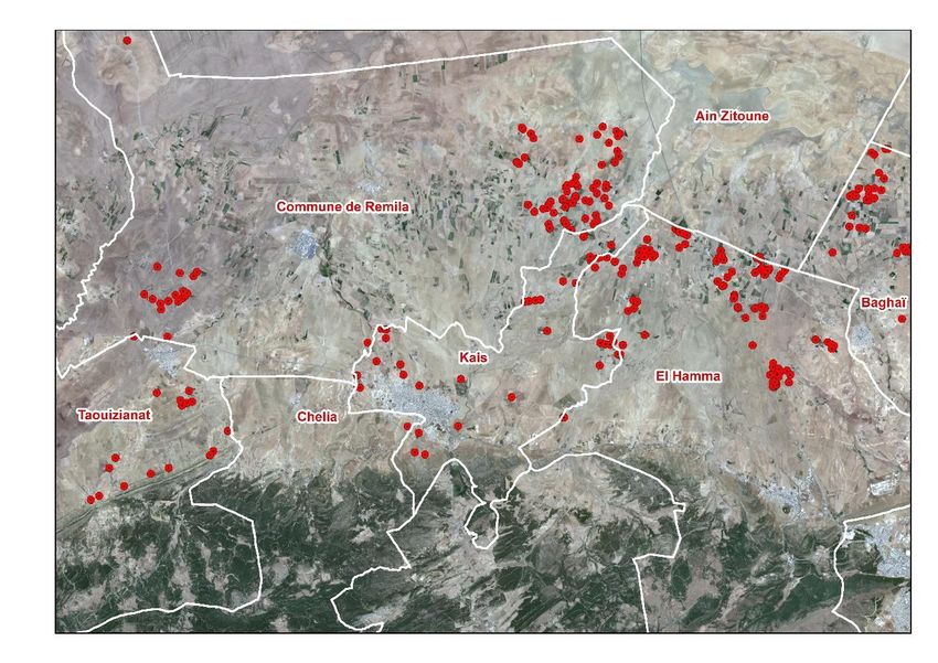
Sahara and Sahel Observatory (OSS) : Who are we ?

•   The Sahara and Sahel Observatory (OSS) is an
    international, intergovernmental organization
    operating in Africa’s Sahara-Sahel region. OSS
    was founded in 1992 and is established in Tunis
    (Tunisia) since 2000.

•   26 African countries, 7 non African countries

•   OSS mission is to support its African member
    countries in the sustainable management of
    their natural resources by integrating climate
    change dimension. It is based essentially on
    knowledge transfer, capacity building and
    awareness-raising.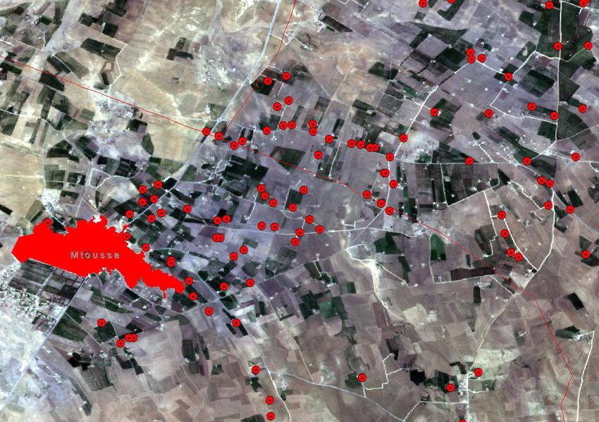
EO integration in water and natural resources management in our zone

            •Skills required for Time-                            •Limitations of
             series Processing                                     access/process EO data,
            •Transform the raw data                                internet bandwidth
             into indicators                                      •Data sharing issues
            •Capacity building                                    •In-situ data

                                           Expertise     Data
Weak integration                                                                 High added value
Weak integration of                                                              Reliable source of
Earth Observation in                                                             orientation in the
Sustainable Water &                                                              decision-making
Land Management                                                                  chain

                                           Missing ?   Hardware

            •Capitalization of expertise                          •Acquisition, storage and
            •End-users involvement                                 processing of EO data
            •Communication                                        •Dissemination issues due
                                                                   to servers limitation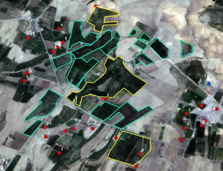
Monitoring progress towards SDG’s : Main Challenges

•   Availability and reliability of data used for SDG’s monitoring

•    Which indicator is more appropriate? It may change in regions inside the
    country, including geographical, socio-economical and climatic, which make
    it difficult to select the appropriate indicator, and to monitor it over time

•   What methodology ? What workflow is more suitable ?

•   What about the accuracy?

•   Accessibility of data for indicators calculation

•   Communication on EO potential for SDG’s monitoring , raising awareness
OSS Operational workflows for EO integration in WNR management

           Identifying WNR manager’s objectives and
           needs

              Exploring the opportunities of using EO to
              design operational solutions

                  Co-design the approaches, products and
                  solutions and Develop first DSS prototypes

                      Feedbacks collection & versioning, setup
                      operational frameworks

                          Technology transfer, capacity building and
                          services appropriation
Regional cooperation for groundwater resources management (CREM)

                                                           Nebhana watershed

                                         Remila-F’kirina plain

                                                                 Tunisia
                 Morocco               Algeria

    Souss-Massa-Draa watershed
Water managers needs

▪ Identifying non-authorized abstraction
▪ Estimate water abstractions (where, when, water abstracts quantification)
▪ Analysis of the actual situation, Solutions / reflections has to be
  proposed: irrigation mode, crops type, farmers behavior, …. ?
▪ Scientific and technical tools allowing the production of accurate
  information on water quantity, scenarios of different profiles in the
  future

Different workshops (information, restitution, planning, field visits,
trainings, …) has been held to ensure and maintain end-users
involvement
Water points inventory
▪ Water points database is a key elements in
groundwater resources management
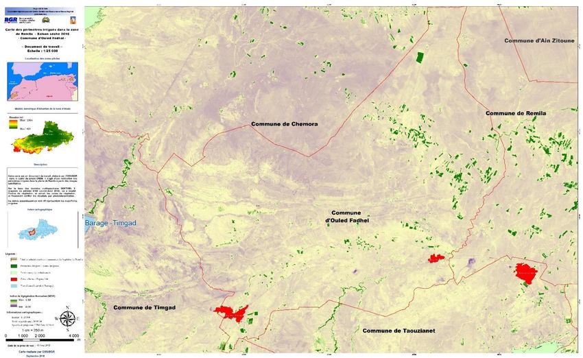
▪ Overlaying the shared database with actual ~3 KM
satellite imagery reveals inconsistencies,
incompleteness and outdates of data
▪ Satellite imagery has been used as support for
identifying anomalies
▪ Results : updated database, as common support
for decision making, shared among the partners
Decision making
was based on wrong
information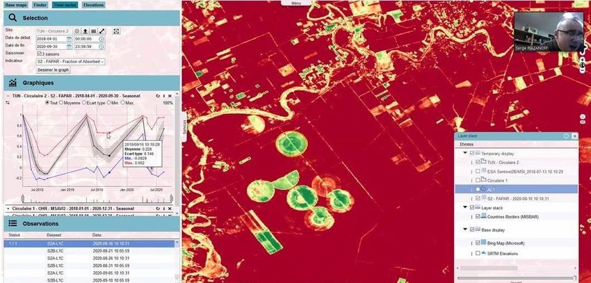
Field visits to update the water points inventory

Field visits have been carried by local partners, using GPS and EO-derived
products
Illicit / Non inventoried water points

Overlay of water points database on Sentinel-2 image acquired during the dry season

      > 50% of abstractions are not inventoried              ▪ Irrigated areas from
                                                               non-inventoried water
                                                               points can be delimited
                                                               from satellite imagery

                                                             ▪ the red dots represent
                                                               the water points
                                                               inventoried on the
                                                               ground, the red
                                                               rectangles represent the
                                                               irrigated areas where no
                                                               water points are
   Sentinel-2 image, acquired on 31st July 2018
                                                               identified
Non inventoried water points (illicit extensions) How to identify illicit water points supposing that all the authorized one are in our database? ▪ The characterization of each water point by a "zone of influence" which corresponds to an agricultural area that can be irrigated from this water point. ▪ Comparative analysis (Areas potentially irrigable from water points) & (Irrigated areas extracted from satellite imagery)
Water points identification from very high resolution satellite imagery

Is-it possible to proceed to a complete water points inventory using satellite imagery ?
•

                                                            ▪ It is possible to inventory
                                                              the wells;

                                                            ▪ It is impossible to identify
                                                              the boreholes;

                                                            ▪ It is impossible to locate
                                                              water points in areas
                                                              not covered by field
                                                              visits.
Irrigated areas mapping from time series Sentinel-2 imagery
Tunisia
AlgeriaIrrigation monitoring in greenhouses context - Morocco
Chtouka plain -
Morocco
Automatic extraction of irrigated areas
(greenhouses & open fields) from Sentinel-
2 time-series imagery
Rainfall : < 200mm/an
Deficit : 60 - 80 million m3 par an
Exportation : 90% of fruits and
vegetables
One model trained on a reference
satellite acquisition (July 2019) is used for
irrigation monitoring (greenhouses &
open field)at monthly basisIrrigated areas mapping and water abstraction estimation
Combining local
knowledge & in-situ
data availability &
field visit constraints
Simple cost-effective
method using
vegetation indices
synthesisGlobal Monitoring for Environment and Security (GMES&Africa)
• Algeria : Algerian Space Agency (ASAL)
• Tunisia : National Center of Mapping and Remote
Sensing (CNCT)
• Libya : Libyan Centre for Remote Sensing and
Space Sciences (LCRSSS)
• Egypt : Desert Research Center (DRC)
• Mauritania : University of Nouakchott Asriya (UNA)
• African Regional Centre for Space Science and Technology Education in
French Language(CRASTE- LF)
• Regional Center for Remote Sensing of North Africa States (CRTEAN)GMES&Africa operational services
03 Operational service based on an optimal and realistic approach, taking into
consideration ancillary data availability , which can be reproduced in other regions
• Water Abstraction Surveillance, Expression of needs
Monitoring and Assessment in in terms of EO-
Irrigated Areas derived products
Translate the needs
into technical
specifications
• Land Degradation Monitoring and
Assessment
Develop well tailored
operational services
• Agriculture Seasonal Monitoring,
Early Warning and Assessment
Appropriation &
capacity buildingGMES&Africa : LULC mapping using Sentinel-2 imagery • Sentinel-2 data has been used for LULC mapping for North-African countries • LULC maps are used as reference layers for operational services development in GMES&Africa
GMES&Africa : in-situ data collection (in synergy with AfriCultureS project)

Field data collection
involving end-users (crop
type, growth stages,
irrigation, …) → model
training and calibration

Meeting with end-users to
present the product and
services, and exchange on
the specificities of the pilot
sites → end-users
involvement and knowledge
experts integration
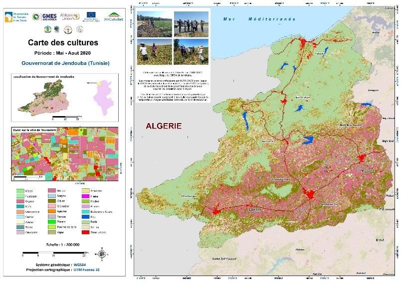
Crop mapping using time-series Sentinel-2 imagery and ML techniques
Crop mapping using time-series Sentinel-2 imagery and ML techniques

                          • Seasonal crop
                            maps

                          • Digital format
                            (ready for GIS
                            analysis…)

                          • Customizable
                            (crops,
                            seasons, …)

                          • Capacity
                            building for
                            local actors

                          • Automatic
                            workflow (to
                            be developed)
MISLAND : GMES Land degradation monitoring service in North-Africa
SDG 15.3.1 (UNCCD
guidelines) + Landsat
integration
Vegetation trends (gain & loss
, Landsat long term analysis)
Global Forest Change
Forest fires (Landsat &
Sentinel-2 for burn scars
mapping)
Assessment of Vulnerability to
desertification (MEDALUS,
RUSLE)MISBAR → GMES Agriculture & Water monitoring services in North- Africa
Capacity building activities

             Training of trainers on advanced EO for WNR monitoring

                 Training of end users on the GMES services use
Conclusion • Copernicus EO time series data coupled with a minimum of in-situ data can be operationally implemented to derive insights in support to decision making • Involvement of end-users is a key measure to provide reliable information and ensure the appropriation of the approaches • There is a lack of awareness on the benefits/importance of using EO data : insufficient communication on mature applications and success stories • Showcasing EO potential for SDG’s reporting and progress measure can be a relevant way to raise awareness. • Developing a replicable approach for monitoring water and natural resources from space is very relevant , we welcome organizations, research centers, and professionals to support us & collaborate with us
Conclusion

                       SDG’s Goals are interlinked
 (Agriculture)  (Water)             (Forest)          (Land Degradation)
  (groundwater pollution)             (Food Security)         (Energy)
       …… → Themes are linked → Ecosystemic approaches and
problems apprehension

• EO advocacy: highlight the relevance of EO for water and natural resources
  monitoring, showcasing and raising awareness

• Develop more user-friendly interfaces for EO services

▪ (Multi-level Raising awareness) and (EO advocacy) → Convince to
  share data → more reliable products → more involvement and
  engagement →→ →→ (iterative process)
Monitoring progress towards SDG’s : a potential solution ???
• Highlighting the potential
Through surveys, feedbacks from
of EO integration in SDG’s
different projects and key experts
monitoring
• Integrate the EO
dimension in national Key indicators
planning (free data)
• Demonstrate through Agriculture Water resources Food Security
operational use-cases at
different levels and scales
the EO potential use, the
challenges and needs.
Communication &
raising awarenessThank you for Questions ? your attention
THANK YOU FOR YOUR ATTENTION
You can also read